Lighthouses of Qatar

The State of Qatar is on the south side of the Persian Gulf, occupying a peninsula that projects 160 km (100 mi) northward into the Gulf east of Bahrain. The capital, Doha, is on the east side of the peninsula. The country has a population nearing three million. Formerly a dependency of Bahrain and then an outpost of the Ottoman (Turkish) Empire, it became a British protectorate after World War I and gained its full independence in 1971. Qatar is a monarchy ruled by the Al Thani dynasty.

A note on nomenclature: the Persian Gulf (as it is usually known in the West) is called the Arabian Gulf in Arabia and the Gulf of Fars in Iran. The International Hydrographic Organization calls it the Gulf of Iran and many commentators avoid all nomenclatural problems by calling it simply "The Gulf".

Aids to navigation in Qatar are the responsibility of the Maritime Transport Division of the Ministry of Transport and Communications, but the Qatar Ports Management Company (Mwani Qatar) operates them. Offshore navigational aids in the Gulf are maintained by the Middle East Navigation Aids Service (MENAS), based in Bahrain.

The Arabic word for a lighthouse is mnarh or manara (منارة). Ra's is the word for a cape or headland, jazīrat is an island, and minā is a harbor.

ARLHS numbers are from the ARLHS World List of Lights. Admiralty numbers are from volume D of the Admiralty List of Lights & Fog Signals. U.S. NGA List numbers are from Publication 112.

General Sources
Online List of Lights - Qater
Photos by various photographers posted by Alexander Trabas.
Middle East Navigation Aids Service -ATON's
A map locating and identifying the MENAS beacons.
World of Lighthouses - Qatar
Photos by various photographers available from Lightphotos.net.
Navionics Charts
Navigational chart for Qatar.

Ra's Umm Hasah Light, Al Ghariya, July 2015
Wikimedia Creative Commons photo by Alexey Sergeev
Lighthouses
Ra's Rakan
Date unknown. Active; focal plane 14 m (46 ft); white flash every 5 s. 14 m (46 ft) skeletal tower mounted on piles. No photo available but Bing has a distant satellite view. Located off the northern tip of Qatar. Accessible only by boat. Site status unknown. Admiralty D7395; NGA 29792.
* Ra's Umm Ḩaşāh (Al Ghariya)
Date unknown. Active; focal plane 12 m (39 ft); three very quick white flashes every 5 s. 11 m (36 ft) round barbell-shaped tower, probably fiberglass, mounted on a square concrete base. Lighthouse is white. One of Alexey Sergeev's photos is at the top of this page, he also has a closeup photo, and Google has a satellite view. Located on the northeastern tip of the Qatar Peninsula, north of Al Ghariya. Site open, tower closed. Admiralty D7394.5; NGA 29794.
#Ra's al Maţbakh (2?)
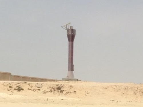
Date unknown. Collapsed in 2018 but still listed with focal plane 17 m (56 ft); flash every 5 s, white or red depending on direction. 11 m (36 ft) round barbell-shaped tower, probably fiberglass. Lighthouse is purple or a very dark red. Mohamed Samy has a 2016 street view from the beach (a portion is seen at right) but Google's 2023 street view and current satellite view show the tower lying on the ground. It's possible the light is now mounted on the nearby communications tower. NGA lists a tripod tower at this location. Located on the north side of the entrance to Al Khawr, on the east coast of Qatar. Site open, tower closed. ARLHS QAT-001; Admiralty D7393; NGA 29812.
Lightfloat Doha
Date unknown. Active; focal plane 6 m (20 ft); one long and two short white flashes (Morse code "D") every 12 s. Racon (radiobeacon). 4.5 m (15 ft) square pyramidal skeletal tower mounted on a rectangular hull. No photo currently available and the light is not seen in Google's satellite view. Located about 15 km (9 mi) east southeast of the entrance to Doha, the capital of Qatar, marking the beginning of the dredged approach channels. Accessible only by boat. Site open, vessel closed. ARLHS QAT-002; ex-Admiralty D7389; NGA 29892.
Doha Approach Channel 13S
Date unknown. Active; focal plane about 18 m (59 ft); quick-flashing red light. Approx. 18 m (59 ft) square concrete skeletal tower. Lightphotos.net has a photo and the platform is barely visible in Bing's satellite view. This light marks a turn in the approach to Doha's main harbor. Located in the entrance to the harbor. Accessible only by boat. Site open, vessel closed. Admiralty D7390.006.
Umm al Hul North Breakwater
2016. Active; focal plane about 15 m (49 ft); three green flashes every 10 s. Approx. 11 m (36 ft) round barbell-shaped tower colored with green and white horizontal bands. Lightphotos.net has a photo and Google has a satellite view. This basin is just north of the main Hamad port on the south edge of Doha. Located on the north breakwater of the port. Site and tower closed. Admiralty D7388.66; NGA 29908.1.

Ra's Maţbakh Light, Al Khawr, September 2016
Google Maps street view by Mohamed Samy
Umm al Hul South Breakwater
2016. Active; focal plane about 15 m (49 ft); three red flashes every 10 s. Approx. 11 m (36 ft) round barbell-shaped tower colored with red and white horizontal bands. Lightphotos.net has a photo and Google has a satellite view. Located on the south breakwater of the port. Site and tower closed. Admiralty D7388.65; NGA 29908.2.
Hamad Port North Breakwater
2016. Active; focal plane about 15 m (49 ft); green light, characteristic unknown. Approx. 11 m (36 ft) round barbell-shaped tower colored with green and white horizontal bands. Lightphotos.net has a closeup photo and Google has a satellite view. Completed in December 2016, the Hamad Port is located on the south edge of Doha. Located on the short north breakwater of the port. Site and tower closed. Admiralty D7388.56.
Hamad Port South Breakwater
2016. Active; focal plane about 15 m (49 ft); red light, characteristic unknown. Approx. 11 m (36 ft) round barbell-shaped tower colored with red and white horizontal bands. No photo available but Google has a satellite view. Located on the long south breakwater of the port. Site and tower closed. Admiralty D7388.5.
Ḩālat Umm al Khayfān
Date unknown. Active; focal plane 13 m (43 ft); two white flashes every 20 s. 13 m (43 ft) tower, painted with red and white stripes, mounted on a square platform supported by piles. No photo available and the light is not seen in Google's satellite view. Located on a dangerous shoal about 50 km (30 mi) southeast of Doha. Accessible only by boat. Operator: MENAS. Site open, tower closed. ARLHS QAT-003; Admiralty D7382; NGA 29912.
Jazīrat Ḩālūl
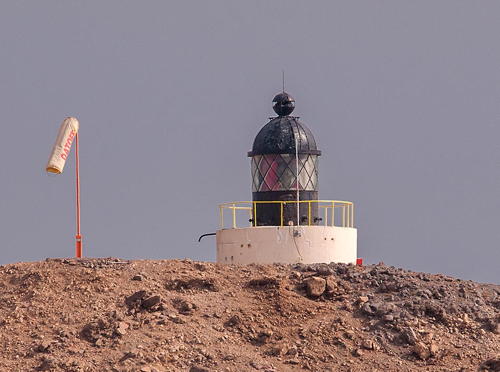
1952. Active; focal plane 67 m (220 ft); flash every 12 s, white or red depending on direction. 5 m (17 ft) round lantern mounted on a circular white concrete base. Lantern painted black. Alexey Sergeev has a photo (also seen at right) and Kevin Nicholas has an aerial view of the island; the light is just visible on the hill at the center. Google has a satellite view. Ḩālūl is a small, isolated island about 80 km (50 mi) northeast of Doha. It serves as a storage area and shipping terminal for nearby oil fields and is also a base for the Qatari navy. In 2011 a contract was advertised for design of a new lighthouse and preservation of the old one; so far this project does not appear to have been carried out. The island is a major port for oil shipments and is nearly covered with the necessary facilities. MENAS. ARLHS QAT-004; Admiralty D7378; NGA 29816.

Jazīrat Ḩālūl Light, Arabian Gulf, April 2013
Wikipedia Creative Commons photo by Alexey Sergeev

Information available on lost lighthouses:

Notable faux lighthouses:

Adjoining pages: North: Southwestern Iran | East: United Arab Emirates | West: Bahrain

Return to the Lighthouse Directory index | Ratings key

Posted April 4, 2012. Checked and revised October 10, 2023. Lighthouses: 10. Lightfloats: 1. Site copyright 2023 Russ Rowlett and the University of North Carolina at Chapel Hill.