Lighthouses of Ukraine: Odessa Area

The Directory's pages for Ukraine describe the lighthouses as they existed before the start of the current conflict between Ukraine and Russia. No changes will be made until there is a stable agreement that stops the fighting.

Ukraine (officially Україна, Ukraina) is a large country on the north side of the Black Sea, bordering Russia. Except for a brief period of independence during the Russian Revolution (1917-20), Ukraine was part of Russian or Soviet empires from the mid seventeenth century until the collapse of the Soviet Union in 1991. However, the coastline of the Black Sea was mostly under the control of the Ottoman (Turkish) Empire until it was taken by Russia during a series of wars in the second half of the 1700s.

The Black Sea's northern coast is in several sections. In the west is the Bight of Odessa, named for Ukraine's largest port. In the center is the diamond shaped peninsula of Crimea. To the east is the Sea of Azov, connected to the rest of the Black Sea by the narrow Kerch Strait at the eastern end of Crimea.

Ukraine is divided into provinces called oblasts (область), and the oblasts are divided into county-level districts called raions (райони). This page includes the lighthouses of the Odessa Oblast, the westernmost section of the Ukrainian coast.

The Ukrainian word for a lighthouse is mayak (маяк); ostriv (острів) is an island, mys (мис) is a cape, richka (річка) is a river, and havan' (гавань) is a harbor.

Lighthouses in Ukraine are maintained by the Derzhhidrohrafiyu, the hydrography and navigation service of the Ministry of Transport and Communications.

ARLHS numbers are from the ARLHS World List of Lights. UA numbers are the Ukrainian light list numbers as reported by Ukrainian Lighthouses on the Air. Admiralty numbers are from volume N of the Admiralty List of Lights & Fog Signals. U.S. NGA List numbers are from Publication 113. The Ukrainian light list, Вогні і знаки Чорного та Азовського морів (Lights and Signs of the Black and Azov Seas), is not available online.

General Sources
Derzhhidrohrafiyu - Lighthouses
Photos and historical information on the Ukrainian State Hydrography web site.
Online List of Lights - Ukraine
Photos by various photographers posted by Alexander Trabas. The photos from Odessa harbor are by Douglas Cameron.
ARLHS - Lighthouses in Ukraine
The ARLHS Ukraine listing; photos contributed by Ukrainian amateur radio operators are available for many of the lighthouses.
Wikimedia - Lighthouses in Ukraine
Photos by various photographers available from Wikimedia.
World of Lighthouses - Ukraine
Photos by various photographers available from Lightphotos.net.
Russische Leuchttürme auf historischen Postkarten
Historic postcard images posted by Klaus Huelse.
Ukraine and Crimea
Historic postcard images posted by Michel Forand.
Navionics Charts
Navigation chart for Ukraine.


Vorontsov Light, Odessa, September 2013
Wikimedia Creative Commons photo by Nata Naval

Lyman District Lighthouses
Several of these lights guide vessels into and around the estuary known as Port Yuzhne, on the north shore of the Black Sea about 40 km (25 mi) east northeast of Odessa. Biliari is a small port on the east side of the estuary, and Novi Biliari is a larger, much newer port on the west side. Under Soviet rule the district was called Kominternivske.

Sychavskiy
Date unknown. Active; focal plane 44 m (144 ft); white light, 1.5 s on, 2.5 s off. 10 m (33 ft) skeletal tower with an enclosed "watch room" structure mounted on the roof of a building. Building painted white. No photo available but Google has a satellite view. Located above the beach about 3 km (1.8 mi) southeast of Sychavka. Site status unknown. ARLHS UKR-053; UA-0472; Admiralty N5108; NGA 17992.
Port Yuzhnyi Lower Range Front
Date unknown. Active; focal plane 47 m (154 ft); continuous green light visible only on the range line. 17 m (56 ft) square cylindrical skeletal tower with lantern and gallery. Tower painted red; the front of the tower is covered by a slatted daymark painted white with an orange vertical stripe. No photo available but Google has a satellite view. This is the entrance range for the estuary. Located in a field east of the estuary, about 1 km (0.6 mi) southeast of Voronivka. Site status unknown. Admiralty N5107.3; NGA 17988.5.
Port Yuzhnyi Lower Range Rear
Date unknown. Active; focal plane 69 m (226 ft); continuous green light visible only on the range line. 29 m (95 ft) square cylindrical skeletal tower with lantern and gallery. Tower painted red; the front of the tower is covered by a slatted daymark painted white with an orange vertical stripe. Vasily Lavrinets has a photo and Google has a satellite view. Located about 1.1 km (0.7 mi) north northeast of the front light. Site open, tower closed. Admiralty N5107.31; NGA 17988.6.
Port Yuzhnyi Upper Range Front
Date unknown. Active; focal plane 35 m (115 ft); continuous red light visible only on the range line. 18 m (59 ft) square cylindrical skeletal tower with lantern and gallery. Tower painted red, lantern yellow; the front of the tower is covered by a slatted daymark painted orange. The tower is at the left in Javier Ortuño García's photo at right, a 2008 distant street view is available, and Google has a satellite view. This range guides vessels northbound inside the estuary. Located at the northern end of the estuary south of Vyzyrka. Site and tower probably closed, but the lighthouse is easy to see from nearby roads. Admiralty N5107.9.
Port Yuzhnyi Upper Range Rear
Date unknown. Active; focal plane 35 m (115 ft); continuous red light visible only on the range line. 18 m (59 ft) square cylindrical skeletal tower with lantern and gallery. Tower painted red, lantern yellow; the front of the tower is covered by a slatted daymark painted orange. The tower is at the right in Javier Ortuño García's photo at right and Google has a satellite view. Located about 275 m (900 ft) north of the front light. Site and tower probably closed, but the lighthouse is easy to see from nearby roads. Admiralty N5107.91.

Port Yuzhnyi Upper Range Front (left) and Rear Lights, June 2019
contributed photo copyright Javier Ortuño García; used by permission
* Hryhorivs'kyi (Grigoryevskiy) (2)
1972 (station established 1955). Active; focal plane 60 m (197 ft); white flash every 3 s. 15 m (49 ft) round vase-shaped concrete tower with gallery. Upper portion painted black, lower portion white. The Derzhhidrohrafiyu has a photo and Google has a street view and a satellite view. This lighthouse marks the west side of the entrance to the estuary south of Hryhorivka. The lighthouse was renovated in 1997, and new lighting equipment was installed. Located next to the coastal highway and about 600 m (0.4 mi) from the coast. Site appears open, tower closed. ARLHS UKR-045; UA-0446; Admiralty N5107; NGA 17988.
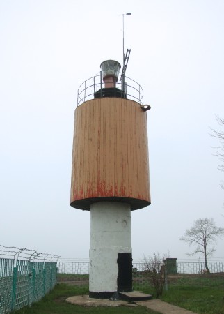
* Luzanovskiy (Mys Severnyy Odesskiy, Odessa North Cape, Cape Lukul)
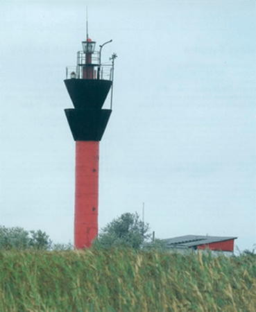
1972. Active; focal plane 56 m (184 ft); white light, 1.5 s on, 3.5 s off. 10 m (33 ft) round cylindrical tower with an expanded upper section and a small lantern and gallery. Lantern and upper section painted red, lower section white. 1-story equipment house nearby. Minami Himemiya's photo is at right, the Derzhhidrohrafiyu has a photo, Dmitry Luchkin has a closeup 2014 photo, and Google has a satellite view. The lighthouse was restored in 1999. Located on a promontory at the north entrance to Odessa Bay, about 16 km (10 mi) northeast of the central city. Site appears open, tower closed. ARLHS UKR-057; UA-0439; Admiralty N5106; NGA 17984.

Odessa City Lighthouses
Odessa (Оде́сса, Odesa in Ukrainian) was founded in 1794, shortly after the Ottoman Empire ceded the area to Russia. The city's ice-free harbor quickly became a major Russian port; it was the largest port in the Soviet Union and an important Soviet naval base. It continues as a major port under Ukrainian administration.

Neftyana Gavan' Range Front
Date unknown. Active; focal plane 22 m (72 ft); continuous green light, visible only on the range line. 22 m (72 ft) square pyramidal skeletal tower with lantern and gallery; the tower carries a large slatted daymark colored red with a white vertical stripe. No photo available but Google has a street view and a satellite view. Located on the quay of Neftyana harbor, a petroleum terminal on the north side of Odessa. Site and tower closed. Admiralty N5103; NGA 17936.
Luzanovskiy Light
Luzanovskiy Light, April 2008
Wikimedia Creative Commons photo by Minami Himemiya
Neftyana Gavan' Range Rear
Date unknown. Active; focal plane 29 m (92 ft); continuous red light, visible only on the range line. 26 m (85 ft) square pyramidal skeletal tower with gallery; the tower carries a large slatted daymark colored red with a white vertical stripe. Google has a street view and a satellite view. Located 200 m (656 ft) northwest of the front light. Site and tower closed. Admiralty N5103.1; NGA 17940.
[Zavods'ka Breakwater North End]
Date unknown. Active; focal plane 11 m (36 ft); red light, 2 s on, 4 s off. 9 m (30 ft) white post rising from a square base. Trabas has Cameron's photo (this light is in the center of the photo) and Google has a distant satellite view. Located at the north end of the breakwater off the northern part of Odessa's harbor. Accessible only by boa. Site and tower closed. Admiralty N5092; NGA 17956.
[Odessa Dredged Channel Range Front]
Date unknown. Active; focal plane 10 m (33 ft); green flash every 3 s, visible only on the range line. 10 m (33 ft) white skeletal mast carrying a red diamond-shaped daymark. Trabas has Cameron's view from the harbor and Google has an indistinct satellite view. Located near the south end of the detached Zavods'ka breakwater. Accessible only by boat. Site and tower closed. Admiralty N5090; NGA 17928.
Odessa Dredged Channel Range Rear
Date unknown. Active; focal plane 25 m (82 ft); continuous green light, visible only on the range line. 22 m (72 ft) mast mounted on a warehouse. The mast carries a red pentagonal daymark. Dimon Dimonovich has a street view and Google has a satellite view. Located in Zavods'ka Gavan', an older section of Odessa's waterfront. Site and tower closed. Admiralty N5090.1; NGA 17932.
[Zavods'ka Breakwater South End]
Date unknown. Active; focal plane 11 m (36 ft); green light, 2 s on, 4 s off. 9 m (30 ft) white post rising from a square base. A 2008 photo is available, Trabas has Cameron's photo and Google has a distant satellite view. Located at the south end of the breakwater off the northern part of Odessa's harbor. Accessible only by boat. Site and tower closed. Admiralty N5091; NGA 17952.
Staryi Breakwater West End
Date unknown. Active; focal plane 11 m (36 ft); red flash every 3 s. 9 m (30 ft) square white concrete skeletal tower. Sergei Leshchinsky has a photo, Igor Belov also has a photo, Trabas has Cameron's photo (this light is at the right in the photo), and Google has a distant satellite view. Located at the west end of the main detached breakwater of Odessa. Accessible only by boat. Site and tower closed. Admiralty N5088; NGA 17924.
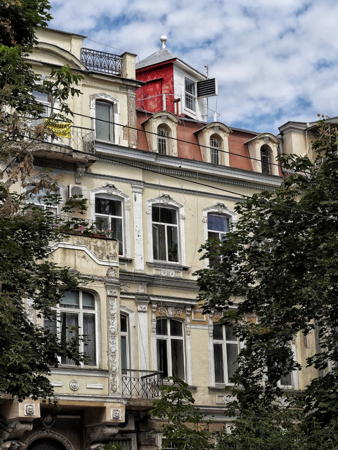
* Stvornyy (Odessa Range Rear)
Date unknown. Active; focal plane 55 m (180 ft); continuous red light. 20 m (66 ft) square tower atop a 4-story building. Front face of the tower painted white, other sides red. Javier Ortuño García's photo is at right and Google has a street view and a satellite view. This is an approach range guiding vessels bound for Odessa from the east. The front light is the Vorontsov lighthouse (see below). Located on the west side of Preobrazhens'ka Street north of Nekrasova Street, several blocks from the Odessa waterfront. Site open, tower closed. Admiralty N5084; NGA 17916.
Staryi Breakwater East End
Date unknown. Active; focal plane 11 m (36 ft); green flash every 3 s. 9 m (30 ft) square white concrete skeletal tower. Igor Belov has a closeup photo, Trabas has Cameron's photo, another photo is available, and Google has a distant satellite view. Located at the east end of the main detached breakwater of Odessa. Accessible only by boat. Site and tower closed. Admiralty N5086; NGA 17920.

Stvornyy (Odessa Range Rear) Light, June 2019
photo copyright Javier Ortuño García; used by permission
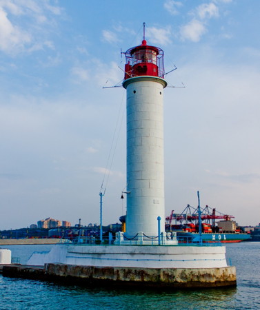
Vorontsov (Reydovyy, Odessa Range Front) (3)
1955 (station established 1888). Active; focal plane 27 m (89 ft); three red flashes every 12 s. 26 m (85 ft) round cylindrical cast iron or steel tower with lantern and gallery, rising from a 1-story concrete building. The lighthouse is white; lantern painted red. Nautophone fog signal (five blasts every 60 s). A photo is at the top of this page, Trabas has Cameron's photo, Todor Kamenov has posted an excellent closeup, ARLHS has a photo, Huelse has a postcard view, and Google has a satellite view. Huelse also has a postcard view of the first (1888) lighthouse, which was blown up by German troops in World War II. It was replaced with a temporary wood tower. Wikimedia has photos of both the original and the new towers. The first Odessa light was placed on a waterfront building in 1845; it was replaced by a cast iron tower on the waterfront in 1863. Located at the end of a curving breakwater that protects the southeastern corner of Odessa's harbor. Accessible only by boat. Site and tower closed, but there are excellent views from cruise ships arriving in the city. ARLHS UKR-033; UA-0340; Admiralty N5082; NGA 17912.
Neftyana Gavan' Outbound Range Rear
Date unknown. Active; focal plane 40 m (131 ft); continuous red light. 15 m (49 ft) triangular gray metal tower carrying a large pentagonal slatted daymark. Viktoriya Kolesnikova has a rainy street view and Google has a satellite view. The front light is on a post on the Staryi Breakwater. The range guides ships departing the Neftyana harbor. Located on a hilltop south of the harbor, near the Monument to an Unknown Sailor. Site status unknown but the light can be seen from nearby. Admiralty N5102.1; NGA 17948.
Otrada
Date unknown. Active; focal plane about 25 m (82 ft); red light, pattern unknown. Approx. 20 m (66 ft) slender square skeletal tower. Ivan Savchenko has a street view and Google has an indistinct satellite view. Located on the north breakwater of the yacht harbor on the east side of Odessa. Site status unknown. Admiralty N5081.
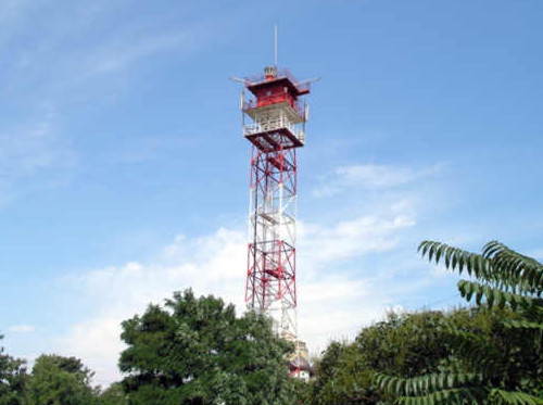
Odessa (Fontana, Odesskiy Zaliv) (3)
Date unknown (station established 1827). Active; focal plane 84 m (276 ft); three white flashes every 12 s. 27 m (89 ft) square cylindrical steel skeletal tower with triple gallery and enclosed watch room, painted with red and white horizontal bands. A photo is at right, ARLHS has a photo, the Derzhhidrohrafiyu has a photo, and Google has a satellite view. This is one of Ukraine's oldest light stations, and it is the traditional landfall light for Odessa for vessels approaching from the south. Forand has a historic postcard view of the original lighthouse, a masonry tower about 15 m (49 ft) tall. Huelse has a 1910 postcard view of the second (?) lighthouse, a cast iron skeletal with central cylinder built in 1901; Forand has a second postcard view. Members of the Zakharov family served as keepers at this station for more than 100 years. Located on heights above Cape Fontana (Mys Velykyy Fontan), a headland about 8 km (5 mi) south of downtown Odessa. Site status unknown. ARLHS UKR-018; UA-0295; Admiralty N5078; NGA 17904.
Fontana Light
Odessa (Fontana) Light, Odessa
unattributed photo from lighthouse21v.narod.ru (no longer online)

Chornomorsk (Illichivsk) City Lighthouses
Chornomorsk (Чорномо́рськ, "Black Sea") is a city about 25 km (15 mi) south of Odessa with a port developed under Soviet rule as Illichivsk. The name was changed to Chornomorsk in 2016. The port is on the Sukhyi Liman. The name of the liman means "dry estuary" because it was formerly cut off from the Black Sea by a sandy barrier. A deepwater channel was cut through the barrier in 1957 to create the port.

*
Chornomorsk (Illichivsk) North Mole
Date unknown. Active; focal plane 12 m (39 ft); green flash every 3 s. 10 m (33 ft) round cylindrical metal tower painted green with a white horizontal band. Irene Newborn has a photo, Oleksandr Getman has a closeup, Radik Sitenko has a street view, and Google has a distant satellite view. Located at the end of the north breakwater at the entrance to Sukhyi Liman. Accessible with caution by walking the narrow pier. Site open, tower closed. Admiralty N5071.4; NGA 17864.
* Sukhyi Lyman (Sukhoy Liman) Range Front
Date unknown. Active; focal plane 40 m (131 ft); continuous green light visible only on the range line. Approx. 38 m (125 ft) square cylindrical skeletal tower with gallery. Upper half of the tower painted black, lower half white. No photo available but Google has a satellite view. The range guides ships within the harbor. Located in a neighborhood on the north side of Sukhoy harbor, about 4 km (2.5 mi) northwest of the Illichivskiy lighthouse. Site open, tower closed. Admiralty N5076; NGA 17892.
Sukhyi Lyman (Sukhoy Liman) Range Rear
Date unknown. Active; focal plane 51 m (167 ft); continuous white light visible only on the range line. Approx. 38 m (125 ft) square cylindrical skeletal tower with gallery. No photo available but Bing has a satellite view. Located in an industrial zone about 250 m (800 ft) north northwest of the front light. Site and tower closed. Admiralty N5076.1; NGA 17896.
Chornomorsk Entrance (Oleksandrivka, Aleksandrouka) Range Front
Date unknown. Active; focal plane 46 m (151 ft); continuous green light. 27 m (89 ft) square cylindrical skeletal tower with gallery, painted black. The tower carries a large rectangular slatted daymark, painted white with a black vertical stripe on the range line. No photo available but Google has a satellite view. Located in an industrial area on the west side of the harbor in Illichivsk. Site and tower closed. Admiralty N5072; NGA 17868.
* Chornomorsk Entrance (Oleksandrivka, Aleksandrouka) Range Rear
Date unknown. Active; focal plane 72 m (236 ft); continuous red light. 29 m (95 ft) square cylindrical skeletal tower with gallery, mounted on a concrete platform supported over a street by four piles. Tower painted black; the tower also carries a large rectangular slatted daymark, painted white with a black vertical stripe on the range line. No photo available but Google has a satellite view. Located spanning Dmytra Horbunova Street west of Verbna Street, 700 m (0.44 mi) west northwest of the front light. Site open, tower closed. Admiralty N5072.1; NGA 17872.
Chornomorsk (Illichivsk, Il'ichevskiy) South Mole
1965. Active; focal plane 20 m (66 ft); red light, 4.5 s on, 4.5 s off, 1.5 s on, 1.5 s off. 18 m (59 ft) round cylindrical concrete tower with lantern and gallery, centered on a 1-story equipment building. Lighthouse painted with red and white horizontal bands; lantern dome painted red, equipment building white. Alexander Vega's photo is at right, Wikimedia has Minami Himemiya's photo, a 2019 drone view and a view from the nearby beach are available, and Google has an indistinct satellite view. Upgraded in 2005, the lighthouse marks the entrance to the Sukhyi Liman and the harbor of Illichivsk. Site status unknown. ARLHS UKR-020; UA-0168; Admiralty N5071; NGA 17860.

Chornomorsk South Mole Light, November 2006
ex-Google Plus photo by Alexander Vega

Ovidiopol District Lighthouse
* Sanzhiika (Sanzijka, Sanzhiyskyy, Sanzheyskiy) (3)
2010 (station established 1921). Active; focal plane 41 m (135 ft); two green flashes every 15 s. 28 m (92 ft) octagonal cylindrical masonry tower with lantern and gallery. Lighthouse painted white, lantern dome green. In 2010 this lighthouse was replaced by a new tower having the same appearance as the old one, but 9 m (30 ft) taller. A photo is at right, Valerie Coretnic has a 2012 closeup photo, a 2016 photo is available, the Derzhhidrohrafiyu has a photo, Ilya Koshkovsky has a panoramic view from the top of the tower, and Google has a good satellite view. Wikimedia has a 2009 photo of the shorter 1957 tower and ARLHS also has a photo. Located above the beach about 16 km (10 mi) northeast of the mouth of the Dnister and about 15 km (9 mi) southwest of Illichivsk. Site open, tower closed. ARLHS UKR-028; UA-0158; Admiralty N5068; NGA 17848.

Budjak: Bilhorod-Dnistrovskyi District Lighthouses
The coastal region between the Dnister and Danube Rivers was known historically as Budjak. After being taken from the Ottoman Empire by Russia in 1812 this border region had a complex history, with control alternating between Russia and Romania. In 1940 Romania was forced to cede Budjak to the Soviet Union, and following World War II it remained under Soviet control until the Union's collapse in 1991. Since then Budjak has been part of Ukraine. A bridge over the Dnister on the coastal P70 highway at Zatoka is the only direct connection between Budjak and the rest of Ukraine.

Tsaregradskoe Girlo Range Front (2?)
Date unknown (station established 1945?). Inactive since 2015. 21 m (69 ft) square cylindrical steel skeletal tower with gallery, painted red. The upper half of the front of the tower is covered by a slatted daymark, painted red with a white vertical stripe on the range line. ARLHS has a photo, this light is near the center in S. Tuberkel's 2014 photo, and Bing has a satellite view. This was apparently an approach range for the mouth of the Dnister River, but the range was discontinued in 2015. This front tower was not removed, however; it is seen on the right in a 2018 photo by Ruslan Lenets. Located on the waterfront at Zatoka, on the south side of the inlet. Site appears open, tower closed. ARLHS UKR-096; ex-UA-0090; ex-Admiralty N5060; ex-NGA 17840.
 

2010 Sanzhiika Light, July 2012
ex-Panoramio photo copyright Alex Helgi; used by permission
* Tsaregradskoe Girlo Entrance
2015. Active; focal plane 25 m (82 ft); quick-flashing white light seen only along the line of approach. Approx. 30 m (98 ft) square cylindrical tower. This light guides vessels in the entrance channel for the mouth of the Dnister River. Yuri Sotnik has a 2016 photo, this tower is in the foreground of a 2018 photo by Ruslan Lenets, and Google has an indistinct satellite view. This leading light replaced the former range lights. Located northwest of the former front range light, near the highway P70 bridge. Site appears open, tower closed. Admiralty N5060.5.
* Tsaregradskoe Girlo (Range Rear, Zatoka) (6)
1989 (station established at least by 1827). Active; focal plane 34 m (112 ft); white light, 3 s on, 4.5 s off. 32 m (105 ft) square steel skeletal tower with gallery, painted red. The upper half of the front of the tower is enclosed by a large daymark painted red (formerly painted with red and white horizontal bands) and with a white vertical stripe on the range line. the Derzhhidrohrafiyu has a photo showing the daymark all red, ARLHS has a photo, Google has a 2021 street view, and Bing has a satellite view. This is a landfall light for the mouth of the Dnister River, and originally it was the rear light of the approach range. Wood lighthouses were built to mark this entrance in 1827, 1851, and 1884. In 1900 a prefabricated French cast iron tourelle was installed; it survived the early years of World War II but was blown up by retreating German troops in August 1944. Replacement range lights were operating by the end of 1945. Located on the waterfront at Zatoka, 220 m (720 ft) west of the front light and just east of the bridge over the inlet. Site appears open, tower closed. ARLHS UKR-097; UA-0091; Admiralty N5060.1; NGA 17844.
Dnestrovskiy Liman Range Front
Date unknown. Active; focal plane 20 m (66 ft); continuous green light. Approx. 17 m (56 ft) round tower, form unknown. No photo available but Google has a satellite view. This light guides vessels across the Dnister Liman (estuary) to the historic port of Bilhorod-Dnistrovskyi, formerly known as Akkerman. Google has a satellite view of the listed location of the rear light (focal plane 30 m (98 ft); continuous red light) it appears to show a tall mast. The front light is located inside the port area. Site and tower closed. Admiralty N5063.
* Budaki (5?)
1986 (station established 1851). Active; focal plane 38 m (125 ft); white flash every 5 s. 15 m (49 ft) square cylindrical skeletal tower with a small lantern and gallery; the seaward face of the tower carries a slatted daymark painted black with a white vertical stripe. ARLHS has a photo, a 2018 photo is available, the Derzhhidrohrafiyu has a photo, and Bing has an indistinct satellite view. According to the Derzhhidrohrafiyu, the original lighthouse was replaced "several times" and the present light replaced a similar tower built in 1960. This lighthouse stands on one of the highest points of the long, sandy coastline stretching southwest from the mouth of the Dnister River. Located above the beach at Budaki, about 30 km (19 mi) south of Bilhorod-Dnistrovsky. Site appears open, tower closed. ARLHS UKR-084; UA-0059; Admiralty N5056; NGA 17828.

Budjak: Tatarbunarskyi District Lighthouses
* Lebedivka (Burnas)
Date unknown. Active; focal plane 25 m (82 ft); red light, 1 s on, 1 s off. 13 m (43 ft) square cylindrical tower with lantern rising from a 2-story building. Nik Domaretskiy has a view from the beach, Nataliya Dzyuba has a sea view, and Google has a drone view and an indistinct satellite view. Lebedivka, formerly called Burnas, is a seaside resort in far southwestern Ukraine. Located at the northern end of Lebedivka. Site status unknown, but probably open, tower status unknown. Admiralty N5054; NGA 17824.
* Ozero Sagany (Shagany) (2)
1965 (station established 1944). Active; focal plane 20 m (66 ft); white flash every 3 s. 16 m (52 ft) round cylindrical concrete tower with gallery and a prominent topmark in the form of two inverted cones. Tower painted red, topmarks black. A Derzhhidrohrafiyu photo is at right, a 2021 closeup is available, and Google has a satellite view. Located on the barrier beach at the southern end of the Sagany lagoon. Site open, tower closed. Admiralty N5053.6; NGA 17820.

Shagany Light, Tatarbunarskyi District, 2018
Derzhhidrohrafiyu photo

Budjak: Kiliiskyi District (Danube Delta) Lighthouses
The Danube Delta lies mostly in Romania but the northernmost mouths of the river are in Ukraine.

*
Prymorsk (Primorskoye)
Date unknown. Active; focal plane 18 m (59 ft); white flash every 5 s. 12 m (39 ft) square skeletal tower with gallery, carrying a slatted daymark. A 2019 sunset photo is available, Peter Yatchuk has a distant view, and Google has a satellite view. Located about 150 m (165 yd) from the beach at Prymorsk, at the south end of the Sasyk lagoon. Site open, tower closed. Admiralty N5053; NGA 17808.
#Prorvinskiy Rezervnyy Range Rear (?)
Date unknown. Inactive since 2009 and apparently demolished. This was an approx. 20 m (66 ft) square cylindrical skeletal tower with lantern and gallery. No photo available and the range lights are not seen in Google's fuzzy satellite view of the area. Located about 4 km (2.5 mi) south of the entrance to the Prorva branch, the northernmost mouth of the Danube. Site status unknown. ex-Admiralty N5041.2; ex-NGA 17792.
Bystroye Girlo Range Rear
Date unknown. Active; focal plane 17 m (56 ft); white light, 3 s on, 2 s off. 15 m (49 ft) square cylindrical skeletal tower with lantern carrying a daymark painted white with a black vertical stripe. No photo available but Google has an indistinct satellite view. This is the entrance range for the Bystroye Girlo branch of the Danube. The front light is on a 12 m (39 ft) skeletal tower. Located on the north side of the entrance to the Bystroye Girlo branch. Site status unknown. Admiralty N5038.01; NGA 17790.1.

Ostriv Zmiinyi (Snake Island) Lighthouse
Zmiinyi (Zmiyinyy, Zmeiny, Șerpilor, Snake Island)
1846. Active; focal plane 54 m (177 ft); white light, 1.5 s on, 3 s off. 18 m (59 ft) octagonal brick tower with lantern and gallery, attached to a 1-story brick keeper's house. Lighthouse painted white; the lantern is gray metallic. A 2017 photo is at right, the Derzhhidrohrafiyu has a great 2018 photo, Dmitry Kivganov has a photo, and Google has a satellite view of the station. Snake Island is a small limestone island in the Black Sea about 35 km (22 mi) east of the Danube Delta. The island was part of the Ottoman Empire until the Russo-Turkish War of 1828-29, when it was occupied by Russia. The lighthouse was built under Russian control, but in 1856 the island returned to Turkey following the Crimean War. The Turkish administration upgraded the lighthouse with a Fresnel lens in 1862. After the Russo-Turkish War of 1877-78 the island was assigned to Romania. In 1948 it was occupied by Soviet troops, an annexation Romania has never accepted. The Soviets repaired heavy damage the lighthouse had suffered during World War II. The island was inherited by Ukraine in 1991, with Romania still protesting. Under a 1997 treaty between Ukraine and Romania, Ukraine agreed to demilitarize the island, and it is now occupied by a scientific station and civilian border guards. This lighthouse was reported to be destroyed during the early days of Russia-Ukraine War in February 2022. The lighthouse is located at the highest point of the island. Accessible only by boat. Site and tower closed (permission is required for visits). ARLHS UKR-050; UA-0001; Admiralty N5036; NGA 17772.


Zmiinyi Light, July 2017
Google Maps photo by Yuri M.

Information available on lost lighthouses:

Notable faux lighthouses:

Adjoining pages: East: Mykolaiv Area | South: Romania

Return to the Lighthouse Directory index | Ratings key

Posted February 19, 2007. Checked and revised September 22, 2021. Lighthouses: 37. Site copyright 2021 Russ Rowlett and the University of North Carolina at Chapel Hill.