Lighthouses of Russia: Southern Khabarovsk Region

Russia (Россия, Rossiya in Russian) is by far the world's largest country, spanning a little over 150° in longitude. It is organized as the Russian Federation (Rossiyskaya Federatsiya) with members known as federal subjects (sub'yekty federatsii). Russia is primarily a continental nation but it has important coastlines on the Baltic, Black, and Caspian Seas and very long coastlines on the Arctic Ocean and North Pacific Ocean. To guard these coasts it operates hundreds of lighthouses, many of them historic.

This page covers lighthouses of the southern half of Khabarovsk Krai, a huge province on Russia's far eastern coast. The northern coastline of the province faces the Sea of Okhotsk. This page includes lighthouses of the Ulchsky, Vaninsky, and Sovetsko-Gavansky Districts, all of which face the Tartar Gulf, the northern arm of the Sea of Japan. The gulf separates the mainland from the large island of Sakhalin. The major ports in this area are Vanino and Sovetskaya Gavan' (Soviet Harbor), the terminus of the Baikal-Amur Mainline Railroad.

The region is named for Yerofey Khabarov, who explored the area for Russia in 1649-50. However, the region was also claimed by China and in the 1689 Treaty of Nerchinsk Russia gave up its claim to the heart of the territory, the Amur Basin. The situation was reversed in the 19th century as Russians occupied the area, and in the 1858 Treaty of Aigun Russian sovereignty was established.

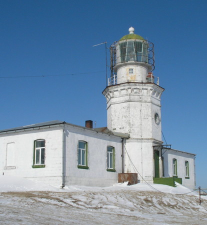
The Krasnyy Partizan (St. Nicholas Point) lighthouse shown at right dates from the very late 1800s but nearly all the other lighthouses in the region were built by the Soviet Union (1917-1991).

The Russian word for a lighthouse is mayak (маяк); ostrov is an island, poluostrov is a peninsula, kosa is a sandy spit, rif is a reef, mys is a cape, bukhta is a bay, zaliv is a larger bay or gulf, proliv is a strait, reka is a river, and gavan' is a harbor.

Russian lighthouses are owned by the Russian Navy and maintained by the Office of Navigation and Oceanography (Управление навигации и океанографии).

ARLHS numbers are from the ARLHS World List of Lights. Admiralty numbers are from volume M of the Admiralty List of Lights & Fog Signals. U.S. NGA List numbers are from Publication 112.

General Sources
Lighthouses of the USSR - Far Eastern Seas
This Russian-language reference provides valuable historical information.
Russian Lighthouse Society
Photos and information on many lighthouses.
World of Lighthouses - Russia Far East
Photos by various photographers available from Lightphotos.net.
Online List of Lights - Russia - Pacific Coast
Photos by various photographers posted by Alexander Trabas.
OpenSeaMap
Navigational chart information for this area.
Krasnyy Partizan Light
Krasnyy Partizan Light, Sovetskaya Gavan', February 2012
ex-Panoramio photo copyright Dmitry Semenov; permission requested

Ulchsky District Lighthouses

De-Kastri Area Lighthouses
De-Kastri is a protected harbor on Chikhachev Bay in the lee of Mys Orlova. In 2003-06 a large terminal was built here for oil exports. The lighthouses of the area were presumably built during that period. The village was named for the French Marquis de Castries by the explorer Jean, Comte de la Pérouse, who discovered the harbor in 1787.

Mys Davydova (Mys Davidova, Mys Nepimetnyy)
Date unknown. Active; focal plane 158 m (518 ft); one long white flash every 5 s. 8 m (26 ft) round concrete tower. No photo available but Bing has a satellite view. Located atop a vertical cliff on the cape on the north side of the entrance to Chikhachev Bay. Site status unknown. Admiralty M7675; NGA 15761.3.
Boba
Date unknown. Active; focal plane and light characteristic unknown. Approx. 15 m (49 ft) square skeletal tower. No photo available but Bing has a satellite view. Located at an oil terminal on the north side of the entrance to De-Kastri harbor. ite status unknown. Admiralty M7675.5.
Ostrov Observatorii
Date unknown. Active; focal plane 27 m (89 ft); quick-flashing white light. 8 m (26 ft) octagonal concrete tower, painted with red and white horizontal bands. No photo available but Bing has a satellite view. Located on the east end of an island in the harbor of De-Kastri. Accessible only by boat. Site status unknown. Admiralty M7676.5; NGA 15761.35.
* Mys Klykova Range Front
Date unknown. Active; focal plane 23 m (75 ft); red flash every 3 s. 10 m (33 ft) octagonal concrete tower with gallery, painted white with a black vertical stripe on the range line. Alexander Temlyantsev's photo is at right, he has another photo, Lightphotos.net has a photo by Sergey Orlov, Pavel Malkov has a distant view, and Google has a satellite view. This is the entrance range for the harbor. Located on a promontory on the north side of the harbor of De-Kastri. Site open, tower closed. Admiralty M7677; NGA 15761.
* Mys Klykova Range Rear
Date unknown. Active; focal plane 42 m (138 ft); continuous red light. 10 m (33 ft) tower with gallery. No photo available but Google has a satellite view. Located on the north side of the harbor of De-Kastri, about 800 m (1/2 mi) west of the front light. Accessible by road. Site open, tower closed. Admiralty M7677.1; NGA 15761.1.

Mys Klykova Front Light, De Kastri, October 2020
Google maps photo by Alexander Temlyantsev
* Mys Innokentiya Range Front (Mys Somon)
Date unknown. Active; focal plane 29 m (95 ft); green flash every 3 s. 11 m (36 ft) octagonal concrete tower with gallery, painted white. Anton Novikov has a 2018 photo and Google has a satellite view. This is an approach range for the harbor. Located on a headland on the south side of the entrance to Chikhachev Bay. Accessible by road. Site open, tower closed. Admiralty M7677.5; NGA 15761.2.
Mys Innokentiya Range Rear
Date unknown. Active; focal plane 42 m (138 ft); green flash every 3 s. 9 m (30 ft) tower, probably skeletal. No photo available but Google has a satellite view. Located about 600 m (0.4 mi) west southwest of the front light. Site status unknown. Admiralty M7677.51; NGA 15761.21.
Orlova (Mys Orlova) (Castries Bay, Klosterkamp Point) (2)
1878 (station established 1861). Inactive. Approx. 7 m (23 ft) square tower attached to a 1-story keeper's house. Google has a satellite view. These are remains of the second lighthouse, which replaced a wood tower built in 1860-61. Located on the extreme point of the cape.
Orlova (Mys Orlova) (Castries Bay, Klosterkamp Point) (3)
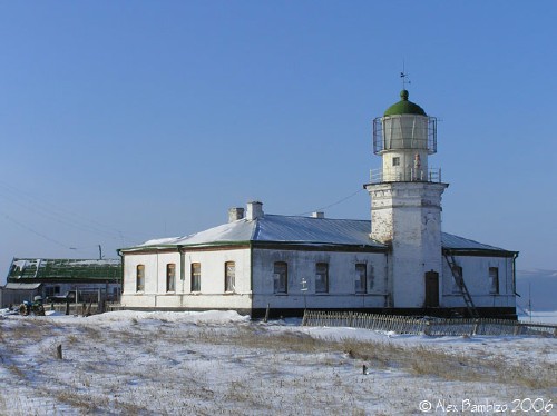
1897 (station established 1861). Active; focal plane 84 m (276 ft); three long (2 s) white flashes every 20 s. 16 m (52 ft) octagonal cylindrical tower with lantern and gallery, attached to the front of a 1-story keeper's house. Lighthouse painted white, lantern black. Alex Bambizo's photo is at right and Google has a satellite view. The lighthouse was the site of a battle between Red and White forces in early 1920; the White forces fortified the lighthouse, which was fairly heavily damaged in the fighting. The name of Klosterkamp Point was changed in 1952 to honor Dmitry Ivanovich Orlov (1805 - 1859), who explored this area shortly before his death. Located on an island off the point of the cape on the south side of the entrance to De Kastri. Accessible only by boat. Site status unknown. ARLHS ASR-050; Admiralty M7678; NGA 15760.
Mys Orlova Light
Mys Orlova Light, De Kastri, 2006
photo copyright Alex Bambizo; used by permission
De-Kastri South
Date unknown. Active (?); focal plane about 22 m (72 ft); red light, pattern unknown. Approx. 8 m concrete tower painted with red and white hroizontal bands. A 2014 photo is avalable and Google has a fuzzy satellite view. Located on the cape opposite the Orlova island marking a narrow south entrance to the De-Kastri harbor. Site status unknown. Not listed by the Admiralty.
Mys To
Date unknown. Active; focal plane unknown; flashing white light. Approx. 10 m (33 ft) concrete tower. No photo available but Bing has a distant satellite view. Located on a prominent cape about 50 km (30 mi) south of De Kastri. Site status unknown. Admiralty M7674.1.

Vaninsky District Lighthouses

Northern Tartar Gulf Lighthouses
The Tartar Gulf (also called the Tatar Strait, Strait of Tartary, or Gulf of Tartary) is a funnel-shaped arm of the Sea of Japan that separates the Russian mainland from the southern portion of Sakhalin Island. The Nevel'skoy Strait is at the tip of the funnel.

Syurkum (Mys Syurkum) (2)
1992 (station established 1934). Active; focal plane 75 m (246 ft); white flash every 8 s. 15 m (49 ft) round fiberglass tower colored with red and white horizontal bands. Andrew Ni has the view from the sea at right and Google has a satellite view. The original lighthouse was a 7.5 m (25 ft) round steel tower on a concrete pyramidal base that stood behind a wood keeper's cottage. The cottage burned to the ground in 1986 (leading to the automation of the light) but several buildings of the original station are seen in the fog behind the current light in Ni's photo at right. The steel tower had to be removed in 1990 due to advanced corrosion. It was replaced in 1992 by the fiberglass tower, the only such tower in Russia. The ruined structure in front of the light is apparently a "technical building" built in 1957. Located on a very prominent cape jutting into the Tartar Strait about 125 km (75 mi) north of Sovetskaya Gavan' and 15 km (10 mi) southeast of Syurkum. Site status unknown. ARLHS ASR-067; Admiralty M7674; NGA 15768.
Mys Bychiy
Date unknown. Active; focal plane 134 m (440 ft); white flash every 3 s. 8 m (26 ft) octagonal white concrete tower. No photo available but Bing has a distant satellite view. Located on a prominent cape about 100 km (60 mi) north of Sovetskaya Gavan'. Site status unknown. Admiralty M7673.

Mys Syurkum Light, Syurkum
ex-Panoramio photo by Andrew Ni salvaged by Mapio.net

Vanino Area Lighthouses
Vanino is an important port about 20 km (13 mi) north of Sovetskaya Gavan'. It is the mainland terminal for passenger and rail ferries to Khomsk, Sakhalin, and it ships goods to other Russian cities of the far east such as Magadan and Petropavlovsk-Kamchatsky.

Mys Datta
1934. Active; focal plane 85 m (279 ft); white light, 3 s on, 4.5 s off. 12 m (39 ft) round steel tower, painted with black and white horizontal bands. Square 1-story keeper's house. No photo available but Google has a satellite view of the station. Located on a prominent cape about 25 km (15 mi) northeast of Vanino. Site status unknown. ARLHS ASR-025; Admiralty M7670; NGA 15776.
Ostrov Dyuanka
Date unknown. Active; focal plane about 14 m (46 ft); quick-flashing white light. Approx. 6 m (20 ft) concrete tower, upper half painted black and lower half yellow. Alexander Petrov has a distant view and Google has a satellite view. Located on a small island off the end of a sharp headland about 10 km (6 mi) north of Vanino. Accessible onky by boat. Site status unknown. Admiralty M7667.
Mushke (Muchkye)
Date unknown. Active; focal plane 17 m (56 ft); white flash every 5 s. 5 m (17 ft) octagonal white concrete tower. Vladimir Polenov has a distant view and Google has a satellite view. Located on a promontory about 4 km (2.5 mi) northeast of Mys Khoy. Site status unknown. Admiralty M7660; NGA 15796.
Valyuk
Date unknown. Active; focal plane about 10 m (33 ft); light characteristics unknown. Approx. 7 m (23 ft) round white concrete tower. Alexandr Russ has a photo and Google has a satellite view. Located at the end of coal terminal pier a short distance east of the Mushke light. Site and tower closed. Admiralty M7655.
Mys Khoy
Date unknown. Active; focal plane 30 m (98 ft); red flash every 5 s. 5 m (17 ft) octagonal white concrete tower. No photo available but Google has a satellite view. Located on a promontory marking the north side of the entrance to Vanino. Site status unknown. Admiralty M7651; NGA 15788.
Mys Severnyy
Date unknown. Active; focal plane 22 m (72 ft); green flash every 5 s. Approx. 17 m (56 ft) square red tower. No photo available but Google has a satellite view. NGA lists the light as "Prichal No. 3"; this confuses the light with another pierhead light (M7252.6). Located at the end of an oil terminal pier on the north side of the entrance to Vanino. Site and tower closed. dmiralty M7654; NGA 15794.
* Vanino Range Front (2)
1958 (station established 1947). Active; focal plane 50 m (164 ft); red light occulting once every 3 s. 14 m (46 ft) octagonal masonry tower with gallery, mounted on a square masonry base. Lighthouse painted white with a broad red vertical stripe on the range line. Nadezhda Vychegzhanina's photo is at right, there's a good closeup, Pavel Bunygin has a 2007 photo, and Google has a street view and a satellite view. This lighthouse is located in a traffic island in the intersection of two major streets near the waterfront of Vanino; one of the streets, Primorskiy Boulevard, is aligned with the range. Site open, tower closed. ARLHS ASR-159; Admiralty M7653; NGA 15792.
* Vanino Range Middle (2)
1958 (station established 1947). Active; focal plane 68 m (223 ft); continuous red light. 9 m (30 ft) octagonal masonry tower with gallery, mounted on a square masonry base. A closeup photo is available and Google has a street view and a satellite view. Located in the median of Primorskiy Boulevard about 330 m (360 yd) west of the front light. Site open, tower closed. Admiralty M7653.1; NGA 15792.2.
* Vanino Range Rear (2)
2014 (station established 1989). Active; focal plane 91 m (299 ft); continuous red light. Light mounted on the roof of the Vanino city hall. The building was demolished and rebuilt in 2014. Google has a street view and satellite view. There is also a photo of the original building. Located at the west end of Primorskiy Boulevard. Site open, tower closed. Admiralty M7653.2; NGA 15792.4.
Vanino Range Front Light
Vanino Range Front Light, Vanino, June 2010
ex-Panoramio photo copyright Nadezhda Vychegzhanina
used by permission
Mys Yuzhnyy (South Cape)
Date unknown. Active; focal plane 21 m (69 ft); red flash every 5 s. 5 m (17 ft) octagonal white concrete tower. No photo available but Google has a satellite view. Located on a promontory marking the south side of the entrance to Vanino. Site status unknown. Admiralty M7652; NGA 15790.

Sovetsko-Gavansky District Lighthouses

Sovetskaya Gavan' (Sovgavan) Area Lighthouses
Founded in 1941, Sovetskaya Gavan' ("Soviet Harbor") is the western terminus of the Baikal-Amur Mainline (BAM). The BAM is a rail line built as a strategic alternative to the Trans-Siberian Railway; it is farther from the Chinese border and much shorter than the route of the Trans-Siberian. The BAM was the last great public works project of the Soviet Union, finally finished in 1991 just before the union came apart. Since then Sovetskaya Gavan' has developed rapidly as an important port. Russians often abbreviate its name as Sovgavan. The harbor is a deep bay, the best protected harbor of Russia's Sea of Japan coast. It was originally named Imperatorskyu Gavan' (Imperial Harbor).
Milyutina (Mys Milyutina)
1915. Active; focal plane 24 m (79 ft); red light, 3 s on, 4.5 s off. 8 m (26 ft) octagonal cylindrical tower with lantern and gallery, painted white; lantern dome is green. A view is at right and there is a Google satellite view of the station. The lighthouse was "reconstructed" in 1957, and the present 1-story keeper's house was built at that time. Located on the north side of the harbor entrance at Sovetskaya Gavan'. Site status unknown. ARLHS ASR-046; Admiralty M7643; NGA 15784.
Mys Alexandra
Date unknown. Active; focal plane 30 m (98 ft); red flash every 5 s. 5 m (17 ft) octagonal white concrete tower. No photo available but Google has a satellite view. Located on a promontory marking the east side of the entrance to the northern lobes of the bay. Site status unknown. Admiralty M7642.5.
Mys Gavrilova
Date unknown. Active; focal plane 16 m (52 ft); white flash every 4 s. 5 m (17 ft) octagonal white concrete tower. No photo available but Google has a satellite view. Located on a promontory due north of Mys Sharypova that separates the northeastern and northwestern arms of the bay. Site status unknown. Admiralty M7642.4.
Mys Sharypova
Date unknown. Active; focal plane 17 m (56 ft); red flash every 4 s. 5 m (17 ft) octagonal white concrete tower. No photo available but Google has a satellite view. Located on a promontory marking the west side of the entrance to the northern lobes of the bay. Site status unknown. Admiralty M7642.3.
Mys Aleksandry
Date unknown. Active; focal plane unknown; white light, pattern unknown. Approx. 9 m (30 ft) white concrete tower. No photo available but Google has a satellite view. Located on cape separating the northeastern and northwestern arms of the bay. Site status unknown. Admiralty M7642.2.

Mys Milyutina Light, Sovetskaya Gavan'
Sovetsko-Gavansky District photo
Mys Marii (Zaliv Sovetskaya Gavan') Range Front (2)
1960 (station established 1949). Active; focal plane 51 m (167 ft); red, white or green light, depending on direction, occulting once every 3 s. 16 m (52 ft) octagonal white concrete tower with lantern, gallery, and a black vertical stripe on the range line. No photo available. Lighthouses of the USSR discusses these range lights (3/4 the way down the page); Google has a good satellite view. Both range lights are still listed by international lists, but a local correspondent reports that the front light has been converted to a directional light and the rear light is deactivated. Located at the head of Sovetskaya Gavan Bay. Site status unknown. Admiralty M7639.
Mys Marii (Zaliv Sovetskaya Gavan') Range Rear
1960 (station established 1949). Reported inactive but still listed by the Admiralty. 10 m (33 ft) octagonal white concrete tower with lantern, gallery, and a black vertical stripe on the range line. Lighthouses of the USSR discusses these range lights (3/4 the way down the page) and has a photo of the rear light; Google has a good satellite view. Located 800 m (1/2 mi) southwest of the front light. Site status unknown. Admiralty M7639.1.
Mys Marii
Date unknown. Active; focal plane 16 m (52 ft); white flash every 5 s. 5 m (17 ft) octagonal white concrete tower. This is probably a twin of the Sovgavanskiy lighthouse. Yriy Yriev has a distant view and Google has a satellite view. Located on a cape on the west side of the entrance to the inner harbor of Sovetskaya Gavan', opposite the Sovgavanskiy light. Site status unknown. Admiralty M7638.5.
Ostrova Ustritsa
Date unknown. Active; focal plane unknown; white light, pattern unknown. Approx. 9 m (30 ft) white concrete tower. A distant view is available (lighthouse at the left end of the island) and Google has a satellite view. Located at the north end of an island off the inner harbor. Site status unknown. Admiralty M7640.3.
* Sovgavanskiy
Date unknown. Active (?); focal plane 14 m (46 ft); green flash every 5 s. 5 m (17 ft) octagonal cylindrical white concrete tower with gallery. Uriy Sergeev's 2015 photo is at right, Vladimir Khakhaev has a closeup photo and Google has a satellite view. Located in Sovetskaya Gavan', on the east side of the entrance to the inner harbor. Site open, and apparently it's possible to climb the tower. Admiralty M7638.
Mys Putyatina
Date unknown. Active; focal plane 21 m (69 ft); white light occulting once every 3 s. 7 m (23 ft) octagonal concrete tower, painted white with one red horizontal band. Max Bogachkin has a closeup photo and Google has a satellite view. Located on the cape at the south side of the entrance to Sovetskaya Gavan. Site status unknown. Admiralty M7642; NGA 15798.

Sovgavanskiy Light, Sovetskaya Gavan', February 2015
ex-Panoramio photo copyright Uriy Sergeev; used by permission
* Krasnyy Partizan (Mys Krasnyy Partizan, Mykolaivsky, St. Nicholas Point)
1897. Active; focal plane 85 m (279 ft); two white flashes every 30 s. 16 m (52 ft) octagonal cylindrical stone tower with lantern and gallery, attached to the front of a 1-story keeper's house. Lighthouse painted white. Fog horn (one long and one short blast every 30 s). Original French Fresnel lens still in use. Dmitry Semenov's photo appears at the top of this page, Evgeny Kozlov has a foggy 2017 closeup, another photo is available, and Google has a good satellite view. Blogger Ivan Parus has a page with photos of the 1895 fog bell still mounted next to the lighthouse. This is the only 19th century lighthouse of Khabarovsk Krai. The keepers here were killed by an invading White (anti-Communist) army in 1919. Perhaps in their honor the cape was renamed "Red Partisan." Located on a prominent cape jutting into the Tartar Strait on the east side of Sovetskaya Gavan, about 6 km (3.5 mi) southeast of the harbor entrance. Site open, tower status unknown. ARLHS ASR-034; Admiralty M7640; NGA 15812.

Sea of Japan Lighthouses
The sea between Japan, Korea, Sakhalin, and the southern Russian mainland is called the Sea of Japan in Japan and in most western countries. However, Koreans object to the name "Sea of Japan" and call the sea the East Sea or Korea East Sea. The Directory uses the name East Sea on its pages for Korea. The Russian name Yaponskoye More (Японское море) means "Japanese Sea."

Mys Innokent'yevskiy (1? and 2?)
Date unknown. Inactive. Light tower formerly mounted on a 1-story keeper's house, now in ruins. No photo available but Google has a satellite view. We need information on the history of this station. The current light (focal plane 20 m (66 ft); green flash every 3 s) is on a 5 m (17 ft) octagonal masonry tower, painted white. Google also has a satellite view of that light, located about 500 m (0.3 mi) north of the historic structure. Located on a promontory about 50 km (30 mi) south southwest of Sovetskaya Gavan'. Site status unknown, but apparently accessible by road with local knowledge. Admiralty M7637.
Peschanyy (Mys Peschanyy)
1934. Active; focal plane 27 m (89 ft); white light, 1.5 s on, 4.5 s off. 24 m (79 ft) octagonal cylindrical concrete tower with lantern and gallery. Lighthouse painted white, lantern black. 1-story keeper's house and other light station buildings. A view from the sea is at right and Google has a satellite view of the station. The name of the lighthouse means "sandy cape." A daybeacon installed on the cape in 1899 was destroyed during Revolution. Located on a sandy barrier beach about 100 km (60 mi) south of Sovetskaya Gavan', at a point where the coastline changes from northeast-southwest to more north-south. Site status unknown. ARLHS ASR-054; Admiralty M7636; NGA 15820.
Mys Krestovozhvizhenskiy (4)
1996 (station established 1935). Active; focal plane 27 m (89 ft); white light, 3 s on, 4.5 s off. 8 m (26 ft) steel post, painted red, attached to a 1-story equipment building. There is also a large rectangular daymark, apparently painted white with a red border, mounted billboard-style in front of the tower. No closeup photo available but Bing has a satellite view. A wood pyramidal daybeacon was placed here in 1899. A light on a wood pyramidal tower was installed in 1935 and replaced by a similar tower in 1951. In 1960 the light was placed on a short skeletal tower atop the equipment building. Located on a promontory about 70 km (45 mi) south southwest of Mys Peschanyy. Admiralty M7634; NGA 15824.
Mys Bezymyanny (Bukhta Nelma) (2)
1989 (station established 1940). Active; focal plane 80 m (262 ft); white light, 4.5 s on, 7.5 s off. 8 m (26 ft) round metal tower painted white. No photo available but Bing has a satellite view. The first light was on a 3.5 m (12 ft) square concrete pyramid. In 1962 a skeletal mast was mounted atop the pyramid. Located on a promontory at Nel'ma, about 240 km (150 mi) south southwest of Sovetskaya Gavan. Site status unknown. Admiralty M7630; NGA 15828.
Mys Peschanyy Light
Mys Peschanyy Light, Sea of Japan, August 2010
ex-Panoramio photo copyright Moneron; used by permission

Information available on lost lighthouses:

Notable faux lighthouses:

Adjoining pages: North: Northern Khabarovsk Krai | East: Southern Sakhalin | South: Eastern Primorsky Krai

Return to the Lighthouse Directory index | Ratings key

Posted May 19, 2006. Checked and revised March 25, 2023. Lighthouses: 38. Site copyright 2023 Russ Rowlett and the University of North Carolina at Chapel Hill.