Lighthouses of Russia: Southern Sakhalin

Russia (Россия, Rossiya in Russian) is by far the world's largest country, spanning a little over 150° in longitude. It is organized as the Russian Federation (Rossiyskaya Federatsiya) with 85 members known as federal subjects (sub'yekty federatsii). Russia is primarily a continental nation but it has important coastlines on the Baltic, Black, and Caspian Seas and very long coastlines on the Arctic Ocean and North Pacific Ocean. To guard these coasts it operates hundreds of lighthouses, many of them historic.

Sakhalin and the Kuril Islands together form an oblast (province), one of the members of the Russian Federation. Sakhalin, located just off Russia's east coast, is the country's largest island, stretching 950 km (almost 600 mi) from north to south and separating the Sea of Japan to the southwest from the Sea of Okhotsk to the northeast.

Both Japan and Russia became interested in annexing these territories during the mid 1800s. In 1875 the Treaty of St. Petersburg assigned Sakhalin to Russia and the Kurils to Japan, and within a few years Russia began building lighthouses in Sakhalin. In 1905, at the end of the Russo-Japanese War, Russia was obliged to cede the southern half of Sakhalin to Japan, the border being fixed at 50° north latitude. Russia took control of all of the island in 1945, near the end of World War II. Japan renounced its former claims to Sakhalin in the 1951 Treaty of San Francisco.

This page describes lighthouses in the southern half of the island, the region administered by Japan from 1905 to 1945. Curly braces {} enclose the former Japanese names of some of the lighthouses. The island itself is known as Karafuto in Japanese.

Sakhalin Island is divided into 14 districts and one independent city (Yuzhno-Sakhalinsk).

The Russian word for a lighthouse is mayak (маяк); ostrov is an island, poluostrov is a peninsula, kosa is a sandy spit, rif is a reef, mys is a cape, bukhta is a bay, zaliv is a larger bay or gulf, proliv is a strait, reka is a river, and gavan' is a harbor.

Russian lighthouses are owned by the Russian Navy and maintained by the Office of Navigation and Oceanography (Управление навигации и океанографии).

ARLHS numbers are from the ARLHS World List of Lights. Admiralty numbers are from volume M of the Admiralty List of Lights & Fog Signals. U.S. NGA List numbers are from Publication 112.

General Sources
Lighthouses of the USSR - Far Eastern Seas
This Russian-language reference provides valuable historical information.
Sakhalin Lighthouses
Overview (in Russian) and selected photos by Igor Samarin of the Sakhalin Regional Museum in Yuzhno-Sakhalinsk.
Russian Lighthouse Society
Photos and information on many lighthouses.
World of Lighthouses - Russia Far East
Photos available from Lightphotos.net.
Online List of Lights - Russia - Pacific Coast
Photos by various photographers posted by Alexander Trabas. Photos for Sakhalin are by Jim Smith.
Idilesom.com - Sakhalin - Lighthouses
Photos collected by a tourist development site.
Russische Leuchttürme auf Postkarten
Postcard views of historic Russian lighthouses posted by Klaus Huelse.
Navionics Charts
Navigation chart for Sakhalin.


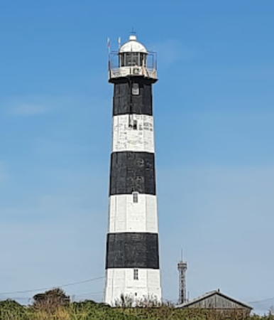
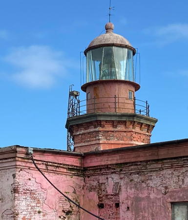
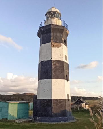
Mys Lopatina Light, Nevelsk, July 2017
Google Maps photo by Vladimir Milkin

East Coast (Sea of Okhotsk) Lighthouses

Poronaysk District (Terpeniya Gulf) Lighthouses
Cape Terpeniya (Cape Patience) is at the end of a 65 km (40 mi) long, finger-like peninsula projecting southeastward from the central east coast of Sakhalin; it is a crucial landmark for navigation in the Sea of Okhotsk. The Terpeniya Gulf (Gulf of Patience) is a broad embayment sheltered by the peninsula. The gulf was named by Dutch explorers who were becalmed in heavy fog when they discovered it in 1643.
Mys Bellingsgauzena
1983. Active; focal plane 42 m (138 ft); white flash every 6 s. 12 m (39 ft) square cylindrical skeletal tower, covered by a vertically slatted white daymark. A very distant view is available and Google has a satellite view of the station. Located on a cape about 50 km (30 mi) north of Mys Terpeniya. Site status unknown. Admiralty M7885; NGA 0192.
Terpeniya (Mys Terpeniya, Cape Patience) {Kitashiretoko Misaki} (2)
1954 (station established 1937). Active; focal plane 71 m (233 ft); white light, 3 s on, 4.5 s off. 41 m (135 ft) round cylindrical concrete tower with gallery, mounted on an octagonal pyramidal concrete base. The lantern was removed in 1989. Tower painted with black and white horizontal bands; base is white. 1-story keeper's house, abandoned. Artemiy Sakh has a view from the sea, Samarin has a historic photo, and Google has a satellite view of the station. The original Japanese lighthouse was a square pyramidal wood tower. Located at the tip of the peninsula. Accessible only by boat. Site status unknown. ARLHS ASR-068; Admiralty M7884; NGA 0196.
* Poronaysk (Poronaisk)
1965. Active; focal plane 33 m (108 ft); two white flashes every 15 s. 32 m (105 ft) octagonal concrete tower with lantern and gallery, painted with black and white horizontal bands. A photo is at right, Lightphotos.net has a photo by Andrey Senyushkin, another good photo is available, and Google has a street view and a satellite view of the station. Located on the west side of the mouth of the Poronay River in Poronaysk, a fishing port on the Terpeniya Gulf. Site probably open, tower closed. ARLHS ASR-057; Admiralty M7875; NGA 0180.
Reka Poronay (Poronay River) Range Front
Date unknown. Active; focal plane 12.5 m (41 ft); continuous red light. 12.5 m (41 ft) square skeletal tower; the light is mounted on an arm extended over the river from the top of the tower. NGA calls this unusual design a "gantry." Google has a street view but the small tower is not conspicuous in Google's satellite view. Located on the river bank about 200 m (220 yd) north of the Poronaysk lighthouse. Site status unknown. Admiralty M7876; NGA 0184.
Reka Poronay (Poronay River) Range Rear
Date unknown. Active; focal plane 21 m (69 ft); continuous red light. 21 m (69 ft) square skeletal tower with gallery. Google has a distant street view and a satellite view. Located on the docks of Poronaysk about 200 m (220 yd) northwest of the front light. Site status unknown. Admiralty M7876.1; NGA 0188.
Goryanka (Mys Goryanskiy)
1986. Active; focal plane 121 m (397 ft); white flash every 3 s. 17 m (56 ft) octagonal cylindrical white concrete tower. Anastasia Ukolova has a 2021 photo, another closeup photo is available and Bing has a satellite view. Located on a promontory about 40 km (25 mi) south of Poronaysk. One of the last lighthouses built by the Soviet Union. The lighthouse is accessble by 4WD. Site open, tower closed. ARLHS ASR-028; Admiralty M7870; NGA 0174.
Poronaysk Light
Poronaysk Light, Poronaysk, June 2012
ex-Panoramio Creative Commons photo by vniz-i-nalevo

Dolinsk District Lighthouse
Starodubskoe Basin Entrance Rear
Date unknown. Active; focal plane 16 m (52 ft); continuous red light. A white triangular daymark and a black vertical stripe on a waterfront building. The light appears to be on a mast seen in a Google street view. Google's satellite view shows the building. Located at Starodubskoe, a small protected harbor about 80 km (50 mi) north of Yuzhno-Sakhalinsk. Site open, tower closed. Admiralty M7860.1.

Korsakov District East Coast Lighthouses
The Korsakov District occupies the Tonino-Aniva Peninsula, the narrow southeastern "toe" of Sakhalin. The peninsula separates Aniva Bay from the open Sea of Okhotsk.

*
Zaliv Mordvinova
1972. Active; focal plane 15 m (49 ft); white light, 3 s on, 3 s off. 9 m (30 ft) square tower rising from a 2-story brick (?) building built as a racon (radar navigation) station in 1969. Anastasia Ukolova's 2021 photo shows two lanterns atop the building, and Google has a street view and an indistinct satellite view. Mordvinova Bay is a bight partly sheltered behind Cape Svobodnyy. Located about 5 km (3 mi) southeast of Okhotskoye. Site open, tower closed. Admiralty M7847; NGA 172.5.
Tonin (Mys Svobodnyy) {Airō Misaki}
1935 (Japanese). Active; focal plane 43 m (141 ft); white flash every 10 s. 23 m (75 ft) round concrete tower, painted with black and white horizontal bands. A clamshell-style Fresnel lens is in use. Fog signal building with a classic diaphone horn. Anastasia Belitskaya has a 2019 photo (seen at right) and a drone view, Roman Fomchenkov has 2020 photo, Andrey Suchkov has a nice view, and Google has a fuzzy satellite view of the station. The lighthouse is reported to be in poor condition. Located on a promontory about 80 km (50 mi) east of Yuzhno-Sakhalinsk, the capital of Sakhalin Oblast. Site status unknown. ARLHS ASR-135; Admiralty M7848; NGA 0172.
Mys Levenorna (?)
Date unknown. Active (?); listed with focal plane 60 m (197 ft); white flash every 6 s. 10 m (33 ft) round metal tower, painted white. No photo available and the tower has not been located in Google's satellite view of the cape. Located on a promontory about 55 km (35 mi) south southeast of the Tonin lighthouse. Site status unknown. Admiralty M7846; NGA 0170.

Tonin Light, Mys Svybodnyy, November 2018
Google Maps photo by Anastasia Belitskaya

South Coast (Aniva Gulf and La Pérouse Strait) Lighthouses

The La Pérouse Strait separates Sakhalin from the Japanese island of Hokkaidō. Named for the French explorer who charted it in 1787, the strait is called Proliv Laperuza in Russian and Sōya Kaikyō (Soya Strait) in Japanese. The narrowest passage of the strait is 43 km (27 mi) wide from Mys Kri'lon in Sakhalin to Sōya Misaki in Hokkaidō.

Korsakov District South Coast Lighthouses
Korsakov is a port at the northern end of the Aniva Gulf, the embayment enclosed by the two capes of Aniva and Kril'on. Founded as a Russian military outpost, the settlement became the town of Ōtomari after Russia ceded southern Sakhalin to Japan. Today Korsakov is a port town with a population of about 30,000.

Aniva (Mys Aniva) {Naka Shiretoko Saki}
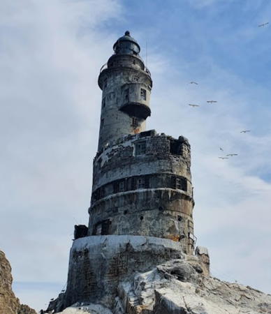
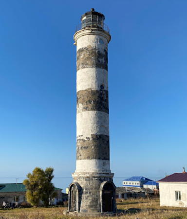
1939 (Japanese). Probably inactive but listed with focal plane 40 m (131 ft); two white flashes every 24 s. 31 m (102 ft) round concrete tower with lantern and gallery, painted with black and white horizontal bands. Lena Maliweva's 2021 photo is at right, Lightphotos.net has a photo, Russian-language Wikipedia has a page for the lighthouse, the Lighthouse Society also has a page, Vitaly Pinevich has a 2017 photo, and Google has an indistinct satellite view. Endangered: the 2017 closeup street view by Konstantin Antipin shows that the lighthouse is abandoned and severely deteriorated. This light marks the very sharp cape at the southeastern corner of Sakhalin, on the north side of the eastern entrance to La Pérouse Strait. Designed by the engineer Shinobu Miura, the lighthouse incorporates 7 floors of crew quarters; its construction at this isolated and dangerous spot was a significant accomplishment of Japanese engineering. Under the Soviet Union the lighthouse was staffed until it was automated in 1990. Today the lighthouse is battered by the weather and much in need of restoration, but restoration has been complicated by remains of a nuclear power unit installed by the Soviets. Apparently this unit has now been removed. Located on a small islet just off the point of the cape. Accessible only by boat in very dangerous seas. Site and tower closed. ARLHS ASR-012; Admiralty M7842; NGA 0168.
* Novikovo
1959. Active(?); focal plane 69 m (226 ft); one long white flash every 5 s. 7 m (23 ft) octagonal cylindrical white concrete tower with gallery. Although this light is listed as active, recent photos show no lens or solar panels. A photo is available but the light has not been found in Google's satellite view of the listed location. Endangered by lack of maintenance. Located on heights southeast of Novikovo, on Aniva Gulf about 50 km (30 mi) southeast of Korsakov. Site open, tower closed. Admiralty M7840; NGA 0165.

Aniva Light, La Pérouse Strait, May 2021
Google Maps photo by Lena Maliweva
Korsakov (Mys Tomari-Aniva) {Ōdomari} (3)
1956 (station established 1906). Active; focal plane 112 m (367 ft); two white flashes every 10 s. 15 m (49 ft) octagonal concrete tower, painted with black and white horizontal bands. A clamshell Fresnel lens is in use. Yadis Li's photo is at right, Trabas has Smith's photo, Wikimapia has several photos, and Google has a street view and a satellite view. The original light was on a "white staff." The Soviets built a temporary pyramidal 3 m (10 ft) tower in 1950. V.E.L. Airup's 2014 photo shows an older lantern removed and sitting on the ground by the tower. Located on a promontory about 3 km (2 mi) south of the city. Accessible by road. Site status unknown. ARLHS ASR-033; Admiralty M7830; NGA 0164.
Korsakov {Ōdomari} South Pier
Date unknown. Active; focal plane 10 m (33 ft); green light, 3 s on, 3 s off. 6 m (20 ft) square cylindrical concrete tower, painted white. Trabas has Smith's photo, V.E.L. Airup has a 2015 photo, Lightphotos.net has a 2011 closeup, and Google has a satellite view. The late Michel Forand had a postcard view showing that this light survives from the Japanese administration. Located at the end of the south pier, one of two major piers at Korsakov. Site status unknown. Admiralty M7831; NGA 0162.5.
* Korsakov Harbor (2)
Date unknown. Active; focal plane 74 m (243 ft); continuous green light. Approx. 6 m (13 ft) round cylindrical tower with gallery, painted white; gallery rail is black. Eugene Eremchenko has a 2017 closeup photo, Trabas has Smith's photo, and Google has a street view and a distant satellite view. The Admiralty describes an earlier light, an octagonal 4 m (13 ft) tower. A closeup of that light is available but apparently it has been demolished. Located on a hill above the harbor of Korsakov. Site open, tower closed. Admiralty M7832; NGA 0162.7.
Korsakov Approach (Korsakov "on Hill")
Date unknown. Inactive and abandoned but still listed with focal plane 54 m (177 ft); white light, 2 s on, 4 s off. 4 m (13 ft) octagonal stone tower painted white. Anastasia Ukolova has a 2021 photo, V.E.L. Airup has a 2013 photo, Lightphotos.net has a distant view, and Google has a fuzzy satellite view. A sibling of the original Korsakov Harbor Light. The Admiralty lists this light as "Korsakov on hill," but NGA applies that label to the Korsakov Harbor Light. Located on a hillside about 2.5 km (1.5 mi) north of the harbor. Site open, tower closed. Admiralty M7828; NGA 0162.4.

Korsakov Light, Korsakov, November 2018
Google Maps photo by Yadis Li

Aniva District Lighthouses
The Aniva District occupies the east side of the Kril'on Peninsula, the southwestern "toe" of Sakhalin, facing east on Aniva Bay.
Kirillovo
Date unknown. Active; focal plane 48 m (157 ft); one long white flash every 5 s. 7 m (23 ft) octagonal stone tower, painted white. No photo available, but Bing has a distant satellite view. Located near Kirillovo on the west coast of Aniva Gulf about 65 km (40 mi) northeast of Mys Kril'on. Site status unknown. Admiralty M7810; NGA 0162.3.
Mys Anastasii (2?)
Date unknown. Active; focal plane 49 m (161 ft); one long white flash every 6 s. 11 m (36 ft) octagonal concrete tower, painted white with a red horizontal band. No photo available but Google has a satellite view. NGA formerly listed an 11 m (36 ft) pyramidal wood tower, presumably the original lighthouse. Located on a promontory near Atlasova, about 16 km (10 mi) northeast of Mys Kril'on. Site status unknown. Admiralty M7806; NGA 0002.
Kamen' Opasnosti {Nijō Iwa} (Rock of Danger)
1928 (Japanese). Active (?); focal plane 19 m (62 ft); white flash every 7.5 s. 18 m (59 ft) round concrete tower with lantern and gallery, originally painted white but very little paint remains. Wikipedia's article has a historic photo but the light is not shown in Google's satellite view. This light marks an exceptionally dangerous rock in the middle of La Pérouse Strait, between Sakhalin and the Japanese island of Hokkaidō. The lighthouse was built by the Japanese authorities after efforts to mark the rock with buoys were defeated by the strong currents in the area. Soviet engineers acted twice to strengthen the tower, in 1963 and 1986. Located in La Pérouse Strait about 15 km (9 mi) southeast of Mys (Cape) Kril'on, the southernmost tip of Sakhalin. Accessible only by boat in very dangerous seas. Site and tower closed. ARLHS ASR-029; Admiralty M7804; NGA 0004.
Kril'on (Krilion, Mys Kril'on, Cape Crillon) (2) {Notoro Misaki}
1896 (station established 1883). Active; focal plane 48 m (157 ft); flash every 10 s, alternately red and white. 15 m (49 ft) octagonal red brick tower with lantern and gallery, rising from the front of a 1-story brick keeper's house. Fog horn (one short and one long blast every 20 s). A photo is at right, Lighthouses of the USSR has a page for the lighthouse, the Lighthouse Society has a page, Lightphotos.net has Sergey Dolya's photo, Russian-language Wikipedia has a page for the lighthouse, another page has several photos, Samarin has a historic photo, and Google has a satellite view. The original lighthouse was an insubstantial wood tower that did not stand up to harsh conditions. Located at the point of Mys (Cape) Kril'on, the southernmost tip of Sakhalin and the north side of La Pérouse Strait. Site status unknown. ARLHS ASR-036; Admiralty M7802; NGA 0008.

Mys Kri'lon Light, La Pérouse Strait, August 2017
Google Maps photo by A D

Southwest Coast (Sea of Japan) Lighthouses

Nevelsk District Lighthouses
The Nevelsk District occupies the west side of the Kril'on Peninsula, facing the Sea of Japan.

Kuznetsova (Mys Kuznetsova) {Sono Misaki}
1922 (station established 1914) (Japanese). Clearly inactive although it was reported reactivated in 2012; listed with focal plane 79 m (259 ft); white flash every 8 s. 8 m (26 ft) square cylindrical concrete tower with lantern and gallery, attached to a 1-story keeper's house. Lighthouse painted white with one black horizontal band. Gena Ivanov's 2020 photo shows an abandoned and endangered lighthouse. The station already appeared to be in very poor condition in a 2010 photo and photos taken in 2011 show no lamp in the tower. Lighthouses of the USSR has a page for the lighthouse, Lightphotos.net has Sergey Dolya's 2017 photo, Timur Ryumshin has a view from the sea, and Bing has a satellite view of the station. The lighthouse was altered or rebuilt in 1961. Located on the cape, west of the town of Kril'on, about 20 km (13 mi) northwest of Mys Kril'on. Site status unknown. ARLHS ASR-041; Admiralty M7800; NGA 0012.
Moneron (Ostrov Moneron, Mys Observatsiy) {Kaiba Shima, Todomoshiri} (3)
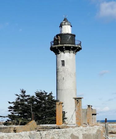
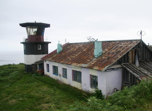
1963 (station established 1914). Active; focal plane 114 m (374 ft); two white flashes every 15 s. 10 m (33 ft) octagonal cylindrical concrete tower with lantern and gallery, accompanied by a crew quarters building. Tower painted black with one white horizontal band. Alexey Bambizo's photo is at right, Lightphotos.net has a 2006 photo, and Google has a satellite view of the station. The original wood lighthouse was replaced by a concrete tower in 1922. Moneron is an island in the entrance to the Tartar Gulf, about 60 km (37.5 mi) west northwest of the town of Kril'on. The island has no permanent population. It is protected as a national park and ecotours are available for adventurous tourists. Located on a very sharp promontory on the east side of Moneron. Site status unknown. ARLHS ASR-047; Admiralty M7794; NGA 0016.
* Lopatino (Lopatina, Mys Lopatina) {Kenushi Misaki}
1919 (Japanese). Active; focal plane 67 m (220 ft); two white flashes every 10 s. 17 m (56 ft) octagonal concrete tower with lantern and gallery, attached to a crew quarters building. Lighthouse painted with black and white horizontal bands. Vladimir Milkin's photo is at the top of this page, Lighthouses of the USSR has a page for the lighthouse, Anastasia Sementsova has a closeup 2020 photo, Lightphotos.net has a 2018 photo, another photo is available, Samarin has a historic photo, and Google has a street view and a satellite view of the station. Located just off the coastal highway on a promontory about 12 km (7.5 mi) south of Nevelsk. Site presumably open, tower closed. ARLHS ASR-042; Admiralty M7788; NGA 0036.
#Nevel'sk Breakwater
Date unknown. Inactive since 2002, although still listed by the Admiralty. This was a 10 m (33 ft) square skeletal tower. No photo available and Vladimir Barguzin's 2018 photo shows that the tower has disappeared, although its square concrete base survives. Google has a distant satellite view of the pier. The Admiralty noted in 2019 that the light was destroyed and had been replaced by a buoy. Nevelsk is a historic fishing port founded by Russian settlers in 1789. It was damaged by an earthquake in 2007 and its population of 11,000 is only half its Soviet-era population. Located at the end of the main (north) breakwater of Nevelsk. Accessible only by boat. Site open, tower closed. Admiralty M7776; ex-NGA 0040.
Moneron Light
Ostrov Moneron Light, Tartar Gulf
photo copyright Alexey Bambizo; used by permission

Kholmsk District Lighthouses
Kholmsk was founded as a Russian outpost in 1870; it was known as Maoka during the period of Japanese control. It is the terminal for a rail ferry crossing the upper end of the Sea of Japan from Vanino in Khabarovsk. The town has a population of about 30,000.
* Kholmsk
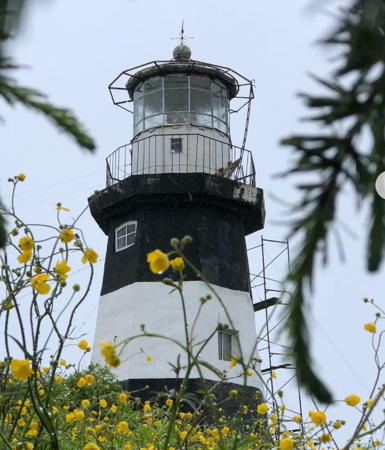
1958. Active; focal plane 67 m (220 ft); three white flashes every 14.1 s. 28 m (92 ft) round concrete tower with lantern and gallery, painted with black and white horizontal bands. A 1913 Barbier, Benard & Turenne Fresnel lens is in use (source unknown). Zhanna Bodnar has a 2021 closeup photo, Elena Ivanova has a 2019 photo, Lighthouses of the USSR has a page for the lighthouse, the Lighthouse Society has a page, Lightphotos.net has a 2014 photo, and Google has a street view (also seen at right) and a satellite view. The lighthouse was originally painted white; the black bands were added in 1963. Located in an industrial area on a promontory on the south side of the harbor of Kholmsk. Site open, tower closed. ARLHS ASR-032; Admiralty M7746; NGA 0056.
Kholmsk Entrance Range Front
Date unknown. Active; focal plane 63 m (207 ft); continuous red light. 5 m (17 ft) octagonal concrete tower painted with a black vertical stripe and mounted atop a 5-story apartment building. Google has a street view and a satellite view. Located on Pobedy Street 154 m (500 ft) northwest of the rear light. Site open, tower closed. Admiralty M7752; NGA 0060.
Kholmsk Entrance Range Rear
Date unknown. Active; focal plane 90 m (295 ft); continuous red light. 10 m (33 ft) octagonal stone tower, painted white with a black vertical stripe on the range line. A closeup photo is available, Wikimapia has a view from the rear, and Google has a street view and a satellite view. Located about 1.5 km (1 mi) north of the Kholmsk lighthouse. Site open, tower closed. ARLHS ASR-129; Admiralty M7752.1; NGA 0064.
* Kholmsk North Breakwater
Date unknown. Active; focal plane 15 m (49 ft); red flash every 3 s. 12 m (39 ft) round 2-stage concrete tower, the lower stage cylindrical and the upper stage tapered to a narrow top, mounted on a square stone pier. Entire lighthouse painted red. Anastasia Ukolova has a 2021 photo, Synar Tydlasheva has a closeup, and Google has a satellite view and a distant street view. Located at the end of the north breakwater of Kholmsk. Site open, tower closed. Admiralty M7748; NGA 0076.
* Slepikovskogo (Slepikovskiy, Mys Slepikovskogo) {Konotoro Misaki}
1934 (Japanese). Active; focal plane 30 m (98 ft); one long (1.5 s) white flash every 10 s. 28 m (92 ft) round cylindrical concrete tower with lantern and gallery, painted red. Lighthouses of the USSR has a page for the lighthouse, the Lighthouse Society also has a page, Viktor Danilov has a photo, Olga Semenchik has a photo, Lightphotos.net has a 2015 photo, Samarin has a historic photo, and Bing has a satellite view. This tower is a sibling of the Lamanon lighthouse (next entry). Located on a promontory about 35 km (22 mi) north of Kholmsk. Site open, tower closed. ARLHS ASR-065; Admiralty M7738; NGA 0100.

Kholmsk Light, Kholmsk, June 2013
Google Maps street view

Central West Coast (Tartar Gulf) Lighthouses

Sakhalin is separated from the mainland on the south by the Tartar Gulf, an arm of the Sea of Japan, and on the north by Sakhalin Bay, an arm of the Sea of Okhotsk. Sakhalin Bay and Tartar Gulf are joined at Lazarev by a narrow passage called the Nevel'skogo (Nevelskoy) Strait. These waterways are known collectively as the Tartar Strait.

Uglegorsk District Lighthouses
Uglegorsk ("Coal Mountain") is a fishing port founded by the Japanese as Esutoru in 1905. It has a population of about 10,000.
* Lamanon (Mys Lamanon) {Chirai Misaki}
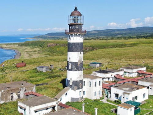
1940 (Japanese). Active; focal plane 71 m (233 ft); white flash every 20 s. 26 m (85 ft) round cylindrical concrete tower with lantern and gallery, painted with black and white horizontal bands. A photo is at right, Nadezhda Stepanova has a 2021 photo, Lighthouses of the USSR has a page for the lighthouse, the Lighthouse Society has a page, Boris Makartsov has a photo, another good photo is available, and Bing has a good satellite view of the station. This lighthouse marks a very prominent cape on the west coast of Sakhalin, directly opposite the port of Sovetskaya Gavan' on the mainland. Located on a promontory about 40 km (25 mi) southwest of Uglegorsk. Site open, tower closed. ARLHS ASR-023; Admiralty M7716; NGA 0104.
Uglegorsk Range Front
Date unknown. Active; focal plane 48 m (157 ft); red light, 3 s on, 3 s off. 11 m (36 ft) octagonal stone tower, painted white with a black vertical stripe on the range line. Anastasia Ukolova has a 2022 photo and Google has a street view and a satellite view. Located on a hillside about 600 m (0.4 mi) south southeast of the harbor of Uglegorsk. Accessible by road. Site status unknown, but perhaps open. ARLHS ASR-058; Admiralty M7713; NGA 0108.
Uglegorsk Range Rear
Date unknown. Active; focal plane 68 m (223 ft); continuous red light. 17 m (56 ft) octagonal stone tower, painted white with a black vertical stripe on the range line. Anastasia Ukolova has a 2022 photo and Google has a satellite view. Located on a hillside 256 m (840 ft) south southeast of the front light. Accessible by road. Site status unknown, but perhaps open. ARLHS ASR-059; Admiralty M7713.1; NGA 0112.
 

Mys Lamanon Light, Uglegorsk
public domain photo by Sakhalin Tourizm
Uglegorsk
1980. Active; focal plane 49 m (161 ft); white light, 3 s on, 3 s off. 14 m (46 ft) white octagonal tower with lantern and gallery, attached to a white service building. A photo is at right, Google has a street view and a satellite view. Located atop a steep bluff at Uglegorsk. Accessible by road. Site status unknown, but perhaps open. ARLHS ASR-136; Admiralty M7711.5; NGA 0132.
Gavrilova (Mys Gavrilova)
1975. Active; focal plane 72 m (236 ft); red light occulting once every 6 s. 10 m (33 ft) octagonal stone tower with lantern and gallery, painted white with one red horizontal band. No photo available but Google has a satellite view. Located on a promontory about 6 km (4 mi) north of Uglegorsk. ARLHS ASR-027; Admiralty M7711; NGA 0140.
Shakhtyorsk Range Front
1979 (station establishment date unknown). Active (?); focal plane 15 m (49 ft); red light, 1.5 s on, 1.5 s off. 16 m (52 ft) octagonal concrete tower, painted white with a black vertical stripe on the range line. Google has a good street view and a satellite view. The light appears to be abandoned. Shakhtersk is the site of a large Sakhalin Energy coal-fired power plant. Located about 10 km (6 mi) north of Uglegorsk. Site status unknown. Admiralty M7709.4; NGA 0148.
Shakhtyorsk Range Rear
Date unknown. Active (?); focal plane 26 m (85 ft); red light, 1.5 s on, 1.5 s off. 10 m (33 ft) square cylindrical skeletal tower carrying a daymark painted white with a black vertical stripe on the range line. Google has a distant street view and a dark satellite view. Located 260 m (850 ft) east southeast of the front light. Site status unknown. Admiralty M7709.41; NGA 0152.

Uglegorsk Light, Uglegorsk, January 1995
photo posted by Lighthouses of the USSR
Nizmenny (Mys Nizmenny) (2)
1979 (station establishment date unknown). Active; focal plane 22 m (72 ft); white light, 1.5 s on, 1.5 s off. 8 m (26 ft) octagonal masonry tower, painted white. Viktor Kopylov has a distant view; in the photo caption he says that the original lighthouse "fell into the sea" in 1978. A closeup photo is also available and Google has a street view and a satellite view. Note: there is another Mys Nizmenny lighthouse on the Russian mainland, on the west side of the Sea of Japan. Located on a promontory about 15 km (9 mi) north of Uglegorsk. Admiralty M7708; NGA 0160.
Boshnyakovo
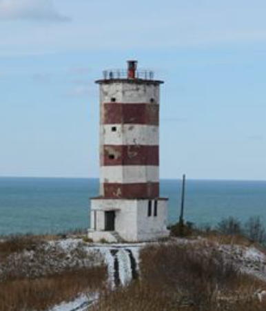
1981. Active; focal plane unknown; one long red flash every 6 s. Approx. 15 m (49 ft) octagonal cylindrical concrete tower with gallery. Lighthouse painted with red and white horizontal bands. The Lighthouse Society has two photos, another photo (first photo on the page) is available and Google has a street view and a satellite view. Located atop a steep bluff on the south side of the small seaport of Boshnyakovo. Site status unknown. Admiralty M7707; NGA 0161.

Information available on lost lighthouses:

Notable faux lighthouses:

Adjoining pages: North: Northern Sakhalin | South: Northern Hokkaidō | Southwest: Southern Khabarovsk | Northwest: Northern Khabarovsk

Return to the Lighthouse Directory index | Ratings key

Posted May 8, 2006. Checked and revised March 12, 2023. Lighthouses: 38. Site copyright 2023 Russ Rowlett and the University of North Carolina at Chapel Hill.