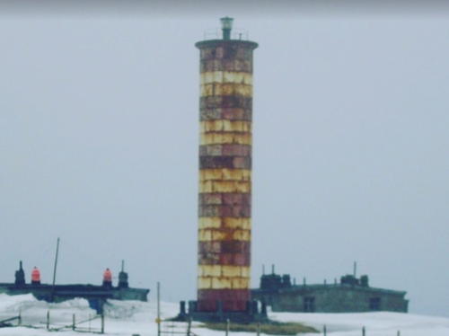
Lighthouses of Russia: Kamchatka

Russia (Россия, Rossiya in Russian) is by far the world's largest country, spanning a little over 150° in longitude. It is organized as the Russian Federation (Rossiyskaya Federatsiya) with members known as federal subjects (sub'yekty federatsii). Russia is primarily a continental nation but it has important coastlines on the Baltic, Black, and Caspian Seas and very long coastlines on the Arctic Ocean and North Pacific Oceans. To guard these coasts it operates hundreds of lighthouses, many of them historic.

Kamchatka Krai, one of the members of the Federation, occupies a volcanic peninsula separating the Sea of Okhotsk from the open Pacific Ocean. Russian occupation of this area began with the explorations of Vitus Bering and Alexsei Chirikov between 1728 and 1741 and the town of Petropavlovsk-Kamchatsky was founded in 1740. However, there was limited development or commerce before the Soviet era. Petropavlovsk was expanded greatly to serve as a naval base for the Soviet Pacific Fleet; it has shrunk in recent years as many military installations were closed but it still has nearly 200,000 inhabitants.

Kamchatka Krai was formed in 2007 by merging the Koryak Autonomous Okrug (region) in the north with the Kamchatka Oblast (province) in the south. Both of these areas are divided into administrative districts (raions).

The Russian word for a lighthouse is mayak (маяк); ostrov is an island, poluostrov is a peninsula, kosa is a sandy spit, rif is a reef, mys is a cape, bukhta is a bay, zaliv is a larger bay or gulf, proliv is a strait, reka is a river, and gavan' is a harbor.

Russian lighthouses are owned by the Russian Navy and maintained by the Office of Navigation and Oceanography (Управление навигации и океанографии).

ARLHS numbers are from the ARLHS World List of Lights. Admiralty numbers are from volume M of the Admiralty List of Lights & Fog Signals. U.S. NGA List numbers are from Publication 112.

General Sources
Маяки Дальневосточных морей (Lighthouses of the Far Eastern Seas)
This site has historical information (in Russian) on the major lighthouses.
Lighthouses of Kamchatka
This Russian-language site has photos and information on several lighthouses of the area.
Russian Lighthouse Society
Photos and information on many lighthouses.
World of Lighthouses - Far East of Russia
Photos by various photographers available from Lightphotos.net.
Online List of Lights - Russia - Pacific Coast
Photos by various photographers posted by Alexander Trabas.
Russische Leuchttürme auf historischen Postkarten
Postcard views of historic Russian lighthouses posted by Klaus Huelse.
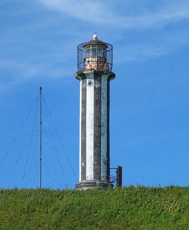
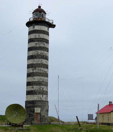
Mys Ozernoy Light
Mys Ozernyy Light, Koryakia, summer 2003
ex-Panoramio photo copyright Victor Morozov
used by permission
Koryak Okrug (Koryakia) East Coast Lighthouses

Olyutorsky District Lighthouses
Koryakia, the former Koryak Autonomous Okrug, was merged into Kamchatka Krai in 2007. This very remote district has a population of only about 25,000; barely one fourth of them are Koryaks, an indigenous people related to the Chukchis of northeasternmost Siberia. Most of the coastal lights in this area have been listed as "temporarily extinguished" by the Admiralty and it is likely that most if not all of them have been abandoned.
Mys Zosimy
Date unknown. Active (?); focal plane 119 m (390 ft); two white flashes every 4 s. 8 m (26 ft) round stone tower painted black. No photo available and Google has only a distant satellite view of the area. Located on a headland on the south side of the entrance to Bukhta Natalia. Site status unknown. Admiralty M8122.7.
Bubnova
1989. Inactive since 2003 but listed with focal plane 141 m (463 ft); white flash every 12 s. 17 m (56 ft) octagonal stone tower painted with black and white horizontal bands. No photo available but Bing has a satellite view. One of last lighthouses built by the Soviet government. This light may have been reactivated but in 2017 the Admirakty listed it again as temporarily extinguished. Located on a headland about 25 km (15 mi) northeast of Mys Irina. Site status unknown. ex-Admiralty M8122.4.
Mys Irina (Mys Olyutorskiy)
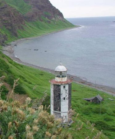
1983. Inactive since 2003 but listed with focal plane 28 m (92 ft); white flash every 4 s. 17 m (56 ft) octagonal cylindrical stone tower painted red. A photo is at right and Bing has a satellite view. Located on a headland about 6 km (10 mi) northwest of Mys Irina. Site status unknown. ex-Admiralty M8122.2.
Apuka
Date unknown. Inactive. Approx. 16 m (52 ft) square cylindrical skeletal tower. Google has a satellite view. Located at the entrance to Apuka, a Koryak village in the lee of Mys Irina. Site status unknown. ex-Admiralty M8122.
Bukhta Lavrova
Date unknown. Active (?); focal plane 40 m (131 ft); white flash every 5 s. 9 m (30 ft) round stone tower painted black with a white horizontal band. No photo available and Google has only a distant satellite view of the area. Located on a headland on the south side of the entrance to Bukhta Lavrova, on the east side of the base of the Govena Peninsula. Site status unknown. Admiralty M8121.6.

Mys Olyutorskiy Light, Koryakia
unattributed photo from Маяки CCCP
Bukhta Yuzhnaya-Glubokaya
Date unknown. Active (?); focal plane 30 m (98 ft); white flash every 4 s. 8 m (26 ft) round stone tower painted with black and white horizontal bands. No photo available but Google has a distant satellite view. Located on a headland about 20 km (13 mi) southwest of the Bukhta Lavrova light. Site status unknown. Admiralty M8121.4.
Smirnova
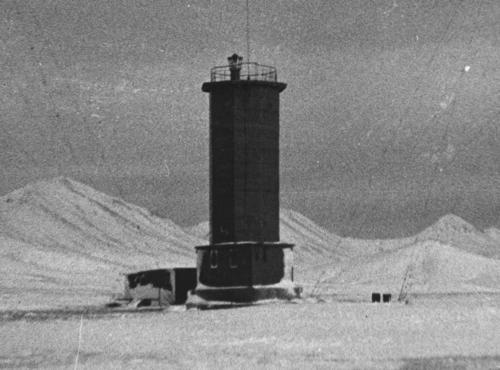
1990. Active (?); focal plane 72 m (236 ft); white flash every 8 s. 17 m (56 ft) octagonal stone tower painted with black and white horizontal bands. Lighthouses of the USSR has a black and white photo and a historical account (halfway down the page). Google has only a distant satellite view of the area. Located on a headland about 16 km (10 mi) northeast of Mys Govena. Site status unknown. Admiralty M8129; NGA 15410.
Mys Govena (1)
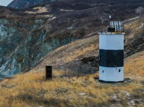
Date unknown. Inactive at least since 2009. 21 m (69 ft) square concrete tower, painted white with a black horizontal band. Svetlana Evfratova's 2018 photo is at right and Bing has a satellite view. In 2009 the Admiralty reported this light had been abandoned. Located at the end of the Govena Peninsula, marking the eastern entrance to the Bay of Korfa. Site status unknown. ARLHS ASR-146.
Mys Govena (2)
2009 (?). Active; focal plane 73 m (240 ft); white light, 2 s on, 4 s off. 12 m (39 ft) square steel skeletal tower with gallery. No photo available. Located near the historic lighthouse. Site status unknown. Admiralty M8130; NGA 15412.
 

Mys Govena Light, Koryakia, July 2018
Google Maps photo by Svetlana Evfratova
 
Skrytyy
Date unknown (?). Active; focal plane 62 m (203 ft); white light, 1.5 s on, 1.5 s off. 8 m (26 ft) octagonal cylindrical white concrete tower with a black vertical stripe. No photo available but Google has a satellite view. The name is misspelled Skrtyy by NGA. Perched on a hill at the head of the Bay of Korfa, just east of the base of the Kamchatka Peninsula. Accessible only by boat. Site open, tower closed. Admiralty M8128; NGA 15408.
Mys Oria
Date unknown (?). Active; focal plane 93 m (305 ft); white flash every 3 s. 11 m (36 ft) square skeletal tower carrying a slatted daymark painted yellow with a black vertical stripe. No photo available but Google has a distant satellite view. Located on the heights of Mys Oria, the western entrance to the Bay of Korfa. Site open, tower closed. Admiralty M8126; NGA 15416.

Karaginsky District Lighthouses
Ostrov Verkhoturova
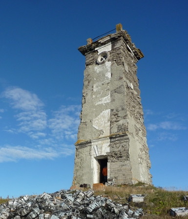
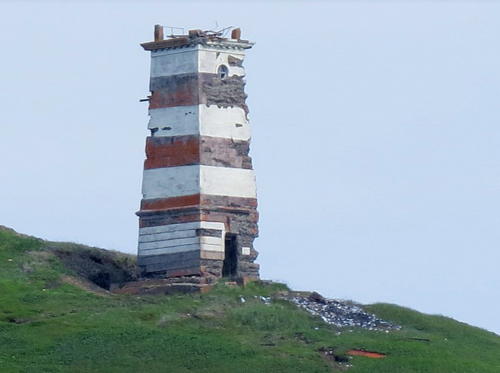
Date unknown. Inactive. Approx. 10 m (33 ft) square masonry tower, formerly covered by a white concrete. Roman Bruehwiler's photo is at right, Andy Wolff has a distant view, and Google has a distant satellite view. Caroline Durre has a 2010 closeup; she found the lighthouse to be abandoned, although it is still listed as active (focal plane 75 m (426 ft); white flash every 4 s). Located on an island in the entrance to Koraginskiy Bay. Accessible only by boat. Site open, tower closed. Admiralty M8125; NGA 15420.
Mys Umalynan
Date unknown. Active (?); focal plane 60 m (197 ft); red flash every 4 s. 8 m (26 ft) square concrete tower, painted black. No photo available but Google has a satellite view. Located at the southeastern point of Il'pyr Island, which separates Anapka Bay from Uala Bay. (The island is connected tenuously to the mainland by a long sand and gravel spit, so it is also known as the Il'pyr Peninsula.) Site status unknown. Admiralty M8121.
Uala
Date unknown. Active (?); focal plane 24 m (79 ft); white light, 3 s on, 3 s off. 8 m (26 ft) round stone tower painted with black and white horizontal bands. No photo available but Google has a distant satellite view. Located on a headland on the west side of Il'pyr Island, marking the east side of the entrance to Uala Bay. Site status unknown. Admiralty M8121.2.

Ostrov Verkhoturova Light, Koryakia, September 2011
ex-Panoramio photo copyright Roman Bruehwiler; used by permission
Kosa Ossorskaya
Date unknown. Active (?); focal plane and light characteristic unknown. Approx. 10 m (33 ft) square concrete or masonry tower. No photo available but Google has a satellite view. The Kosa Ossorskaya (Ossora Spit) is a long peninsula sheltering Ossora Bay. Located near the end of the spit. Site status unknown. Admiralty M8120.6.
Ostrov Karaginskiy (Zl'tnlet)
1977. Active; focal plane 76 m (249 ft); two flashes every 15 s, white or red depending on direction. 10 m (33 ft) octagonal cylindrical concrete tower painted with red and white horizontal bands. A photo is available, Wikimapia has a closeup of the lens, and Google has a satellite view. Karaginskiy is a substantial island, 101 km (63 mi) long and as much as 27 km (17 mi) wide, about 40 km (25 mi) off the northern neck of the Kamchatka Peninsula. It is uninhabited except for the light station, which had a keeper at the time of a 2009 expedition. Located near the southwestern tip of the island. Accessible only by boat. Site open, tower closed. Admiralty M8120.2.
Ozernyy (Mys Ozernyy)
Date unknown. Active; focal plane 59 m (194 ft); white flash every 8 s. 25 m (82 ft) round concrete tower with lantern and gallery, painted with black and white vertical stripes. Victor Morozov has the closeup at the top of this page and Google has a satellite view of the station. NGA misspells the name as Ozernoy. This lighthouse marks a cape at the northeastern corner of the Kamchatka Peninsula, far from any settlements. Site status unknown. ARLHS ASR-052; Admiralty M8120; NGA 15424.

Kamchatka East Coast Lighthouses

Ust-Kamchatsky District (Eastern Kamchatka) Lighthouses
Afrika (Mys Afrika) (2)
1960 (station established 1933). Active; focal plane 38 m (125 ft); white light, 1.5 s on, 4.5 s off. 29 m (95 ft) round concrete tower with lantern and gallery, painted with black and white horizontal bands; lantern dome painted red. Svetlana Evfratova's 2018 photo is at right, Victor Morozov contibuted his 2004 photo, the Lighthouse Society has Morosov's aerial view, Wikimapia also has an aerial photo, and Google has a satellite view of the station. The cape was named for the Russian Navy cruiser Afrika, which mapped this area during an 1882 hydrographic expedition. The original light was on a 10.5 m (34 ft) square wood pyramidal tower. Located on the eastern cape of a very prominent peninsula about 100 km (60 mi) east of Ust-Kamchatsk. Site status unknown. ARLHS ASR-009; Admiralty M8108; NGA 15428.
Osypnoy (Mys Osypnoy, Mys Kruger)
Date unknown. Active (?); focal plane 97 m (318 ft); white flash every 4 s. 10 m (33 ft) square cylindrical skeletal tower carrying two yellow trapezoidal daymarks on two opposite sides. Max Bar has a 2007 photo and Bing has an indistinct satellite view. Located atop a looming headland about 160 km (100 mi) west of Mys Afrika. Site status unknown. Admiralty M8104.

Mys Afrika Light, Ust-Kamchatsky, April 2018
Google Maps photo by Svetlana Evfratova

Northern Yelizovsky District Lighthouses
Kronotskiy (Mys Kronotskyy) (2)
1962 (station established 1944). Active; focal plane 53 m (174 ft); three white flashes every 10 s. 13 m (43 ft) octagonal concrete tower with lantern and gallery, painted with black and white vertical stripes. E. Flippova's photo is at right, Lightphotos.net has a closeup photo by Sergey A. Krasnoshchekov, a 1984 postage stamp image is available, Huelse has a historic postcard view, and Bing has a satellite view of the station. The station was established with a temporary wood tower to guide Soviet warships during World War II. Located on the southeastern tip of the Kronotsky Peninsula, a large protuberance on the east coast of Kamchatka that includes the Otdelnaya volcano. Site status unknown. ARLHS ASR-037; Admiralty M8102; NGA 15432.
Mys Pamyatnik
Date unknown. Active (?); focal plane 38 m (125 ft); white flash every 3 s. 12 m (39 ft) square pyramidal wood tower carrying a white daymark with a red vertical stripe. No photo available but Google has a satellite view. Located on a sharp promontory about 300 km (185 mi) northeast of Petropavlovsk-Kamchatsky. Site status unknown. Admiralty M8098.
Mys Shipunskyy (4)
1964 (station established 1937). Active; focal plane 249 m (817 ft); white flash every 6 s. 12 m (39 ft) square masonry tower, painted with red and white horizontal bands, attached to a 1-story keeper's house. A 2022 photo of the station is available and Bing has a satellite view. The original lighthouse was a 12 m (39 ft) wood tower. Located on a very prominent cape about 80 km (50 mi) east of Petropavlovsk-Kamchatsky. Site status unknown. ARLHS ASR-061; Admiralty M8096; NGA 15440.
Nachal'nyy
Date unknown. Active; focal plane 94 m (308 ft); red flash every 7 s. 6 m (20 ft) square skeletal tower carrying a daymark painted white with a red vertical stripe. No photo available but Google has a distant satellite view. Located near the tip of a sharp peninsula projecting into Morzhovaya Bay. Site status unknown. Admiralty M8085.
Polovinka
1955. Active; focal plane 62 m (203 ft); white flash every 3 s. 15 m (49 ft) square cylindrical steel skeletal tower. Three sides of the tower carry a slatted daymark painted in red and white horizontal bands. Google has a distant satellite view. Located near the village of Polovinka about 25 km (15 mi) east of Petropavlovsk. Site appears open, tower closed. Admiralty M8076; NGA 15440.5.

Mys Kronotskiy Light, Yelizovsky District
Kronotskiy State Reserve photo by E. Filippova (no longer online)

Central Yelizovsky District (Petropavlovsk) Lighthouses
Founded by Vitus Bering in 1740 and named for his two ships Sv. Piotr (St. Peter) and Sv. Pavel (St. Paul), Petropavlovsk-Kamchatsky has a population of about 165,000 and is Russia's easternmost city. It has an important naval base servicing the nuclear submarines of Russia's Pacific Fleet.
* Petropavlovsk (Mys Mayachnyy) (3)
1897 (station established 1850). Active; focal plane 93 m (305 ft); white light, 5 s on, 2 s off. 14 m (46 ft) round cast iron tower with lantern and galley, painted with black and white horizontal bands. Lightphotos.net has a good photo, Oleg Sikhfried has the closeup 2017 photo at right showing the lighthouse freshly painted, Alexey Boldyrev has 2018 street view, the Lighthouse Society has a portfolio of photos, and Google has a satellite view. The light station is the oldest on Russia's Pacific coast; lights were displayed intermittantly from the earliest days of the settlement. This historic lighthouse replaced wood towers built in 1850 and 1886. Located on a promontory at the entrance to Avacha Bay, the city's spectacular harbor. Site open, tower closed. ARLHS ASR-055; Admiralty M8069; NGA 15441.
Ostrov Zavoyko
Date unknown. Active; focal plane about 11 m (36 ft); light characteristic unknown. Approx. 5 m (17 ft) square skeletal tower mostly enclosed by a red daymark. A closeup photo is available, Igor Gromakovsky has a view from the bay, and Bing has a satellite view. Located on the east side of Avacha Bay about 7 km (4 mi) north of the entrance. Accessible only by boat. Site open, tower closed. Admiralty M8072.3.
Bukhta Yuzhnaya Range Front
Date unknown. Active; focal plane about 25 m (82 ft); light characteristic unknown. Approx. 20 m (66 ft) square skeletal tower carrying a large daymark. Google has a distant street view and Bing has an indistinct satellite view. The range guides vessels into Yuzhnaya Bay on the south side of Petropavlovsk. Located on the waterfront of the bay. Site status unknown. Admiralty M8073.
* Bukhta Yuzhnaya Range Rear
Date unknown. Active; focal plane and light characteristic unknown. Approx. 11 m (36 ft) square skeletal tower carrying a large daymark. Located beside a road about southeast of the front light. Google has a closeup street view and Bing has a satellite view. Site open, tower closed. Admiralty M8073.1.
Petropavlovskaya Gavan Range Front
Date unknown (recent). Active; focal plane and light characteristic unknown. Approx. 20 m (66 ft) concrete tower. No photo available but Google has an indistinct satellite view. The range guides ships leaving the Petropavlovsk docks. Site status unknown. Admiralty M8073.155.
Petropavlovskaya Gavan Range Rear
Date unknown (recent). Active; focal plane and light characteristic unknown. Approx. 9 m (30 ft) square cylindrical concrete tower with lantern. Google has a street view but the tower is hidden by trees in Google's satellite view. Located about 100 m (110 yd) southeast of the front light. Site status unknown. Admiralty M8073.156.

Mys Mayachnyy Light, Petropavlovsk, September 2017
Google Maps photo by Oleg Sikhfried
* Petropavlovskaya Guba Range Front
Date unknown. Active; focal plane 56 m (184 ft); red light, 1.5 s on, 1.5 s off. 12 m (39 ft) round cylindrical concrete tower, painted red with a white vertical stripe. Wikimapia has a closeup photo, Google has a street view through trees, and the tower casts a shadow in Google's satellite view. This is the entrance range for the inner harbor. Located on a hillside above the harbor of Petropavlosvsk. Site status unknown, but the tower should be visible from nearby streets. Admiralty M8073.2.
* Petropavlovskaya Guba Range Rear
Date unknown. Active; focal plane 83 m (272 ft); red light, 1.5 s on, 1.5 s off. 8 m (26 ft) round cylindrical concrete tower, painted red with a white vertical stripe. No photo available but the tower casts a shadow in Google's satellite view. Located about 80 m (265 ft) northeast of the front light. Site status unknown, but the tower should be visible from nearby streets. Admiralty M8073.21.
Bukhta Mokhovaya Avachinskiy Range Front
Date unknown. Active; focal plane 73 m (240 ft); red light, 2.5 s on, 5 s off. 20 m (66 ft) square cylindrical skeletal tower carrying a large daymark painted red with a white vertical stripe. Google has a satellite view and a street view through trees. The range guides ships toward the upper end of Avacha Bay. Located on a steep slope near the head of the bay. Site status unknown. Admiralty M8073.5.
Bukhta Mokhovaya Avachinskiy Range Rear
Date unknown. Active; focal plane unknown; red light, pattern unknown. Approx. 20 m (66 ft) square cylindrical skeletal tower carrying a large daymark painted red with a white vertical stripe. Garik Mkrtchyan has a street view and Google has a satellite view. Located in an industrial area about 2 km (1.25 mi) north of the front light. Site status unknown. Admiralty M8073.51.
Mys Vkhodnoy (Vkhodnoy Point)
Date unknown. Active; focal plane about 18 m (59 ft); light characteristic unknown. Approx. 9 m (30 ft) round tower colored with red and white horizontal bands. Andrei Alimpiev has a view from the bay and Bing has a satellite view. Located on a promontory on the west side of Avacha Bay opposite Petropavlovsk. Site status unknown. Admiralty M8071.5.
Mys Kazak
Date unknown. Active; focal plane and light characteristic unknown. Approx. 15 m (49 ft) round tower colored with black and white horizontal bands. Vitaly Filyuchkov has a drone view and Google has a satellite view. Located on a promontory on the west side of Avacha Bay. Site status unknown. Admiralty M8072.2.
Mys Uglovoy
Date unknown. Active; focal plane and light characteristic unknown. Approx. 15 m (49 ft) square cylindrical skeletal tower. Igor Vrzheshch has a drone view but Google has only a fuzzy satellite view of the area. Located on a promontory on the southwest side of Avacha Bay. Site status unknown. Admiralty M8071.
* Stanitskogo (Stanitskiy, Mys Bezymyannyy) (2)
1961 (station established 1954). Active; focal plane 104 m (341 ft); white light, 4.5 s on, 7.5 s off). 8 m (26 ft) octagonal cylindrical concrete tower, painted white, with a small red lantern. A photo is at right, a distant view is available, Igor Vrzheshch has a drone view, and Google has a satellite view. Located on a promontory on the west side of the entrance to Avacha Bay, opposite the Petropavlovsk lighthouse. Site open, tower closed. Admiralty M8070.5; NGA 15441.3.

Stanitskiy Light, Petropavlovsk-Kamchatsky
Russian Navy photo

Southern Yelizovsky District Lighthouses
Ostrov Starichkov (2?)
Date unknown. Active; focal plane 161 m (528 ft); white flash every 4 s. 6 m (20 ft) square skeletal tower carrying daymarks with diagonal striping. Igor Vrzheshch has a drone view and Google has a satellite view. Located atop a steep-sided island about 13 km (8 mi) south of the entrance to Avacha Bay and Petropavlovsk. Site status unknown. ARLHS ASR-084; Admiralty M8068; NGA 15441.6.
Mys Opasnyy (2?)
Date unknown. Active; focal plane 176 m (577 ft); white flash every 6 s. Listed by NGA as a 10 m (33 ft) square skeletal tower but Igor Vrzheshch has a distant 2018 sea view and drone view showing a round concrete tower painted white with a red horizontal band. Google has a distant satellite view. Located on a very steep cape about 25 km (15 mi) south of Petropavlovsk. Site status unknown. Admiralty M8067; NGA 15442.
Mys Russkiy (Mys Vkhodnoy) (4)
1966 (station established 1944). Active; focal plane 61 m (200 ft); white flash every 4.5 s. 8 m (26 ft) octagonal concrete tower, painted with black and white horizontal bands. A closeup photo is at right and Google has a satellite view. The light guides vessels into Russkaya Bay, a protected harbor of refuge surrounded by spectacular scenery. The first lights were established on the north side of the entrance in 1941, when the bay served as an assembly area for Lend-Lease convoys during World War II. Located on a promontory on the south side of the entrance to Russkaya Bay about 50 km (30 mi) south of Petropavlovsk. Site status unknown. Admiralty M8066; NGA 15442.5.
Mys Povorotnyy (5)
Around 1960 (station established 1936). Active; focal plane 181 m (594 ft); white flash every 4 s. 8 m (26 ft) square skeletal tower painted with red and white horizontal bands. No photo available; a fuzzy Google satellite view probably shows the location of the station. An octagonal concrete tower (the fourth light) was built here in 1956 but it was destroyed by an earthquake in 1959. There is a much better known Mys Povorotnyy lighthouse near Nakhodka in Primorsky Krai. Located on a cape about 65 km (41 mi) south of Petropavlovsk. Site status unknown. Admiralty M8065; NGA 15442.7.

Mys Russkiy (Mys Vkhodnoy) Light, Russkaya Bay, November 2020
Google Maps photo by Freeride_Travel Kamchatka
Mys Kruglyy
1966. Active; listed with focal plane 143 m (469 ft); two white flashes every 10 s. 16 m (52 ft) octagonal tower, painted with black and white horizontal bands. The lighthouse was heavily damaged by a magnitide 8 earthqauke in November 1971. It was patched up then but put out of service by another earthquake in 1995. It was restored and reactivated in 2002. Google has a satellite view of the tower. Note: the name means "Round Cape." Located on a promontory in a remote area of Kamchatka's southeast coast, about 100 km (60 mi) south of Petropavlovsk-Kamchatsky. Site status unknown. ARLHS ASR-038; Admiralty M8064; NGA 15516.
Mys Krestovyy
Date unknown. Actiev; focal plane 103 m (338 ft); white flash every 3 s. 10 m (33 ft) square skeletal tower largely enclosed by a daymark painted with red and white horizontal bands. No photo available and the tower is not seen in Bing's distant satellite view. Located on a high promontory about 125 km (75 mi) northeast of Cape Lopatka. Site status unknown. Admiralty M8063.7.
Mys Lopatka (3)
1968 (station established 1933). Active; focal plane 69 m (226 ft); white light, 3 s on, 4 s off. 3 s on, 5 s off. 29 m (95 ft) round cylindrical concrete block tower with gallery and a small lantern. 1-story keeper's house. Tower painted with red and white horizontal bands. Andrey Uchitel's 2021 photo is seen at right, Lightphotos.net has a distant view, another distant view is also available, the light station can be seen in a distant aerial view of the cape, and Google has a satellite view of the station. The original light was on an 8 m (26 ft) pyramidal wood tower. This was replaced in 1957 by a 23.5 m (77 ft) cast iron tower. Located on heights about 3.5 km (2 mi) north of the extreme southern tip of the Kamchatka Peninsula, which is considered to be one of the windiest places in the world. Accessible only by boat or float plane. Site status unknown. ARLHS ASR-043; Admiralty M8063; NGA 15525.

Mys Lopatka Light, Kamchatka, July 2021
Google Maps photo by Andrey Uchitel

Kamchatka West Coast (Sea of Okhotsk) Lighthouses

Ust-Bolsheretsky District (Southwestern Kamchatka) Lighthouses
Mys Kambal'nyy
Date unknown. Active; focal plane 90 m (295 ft); white light, 2 s on, 4 s off. 5 m (16 ft) square skeletal tower carrying a daymark colored with black and white horizontal bands. No photo available and Google has only a fuzzy satellite view of the cape. Located on a headland 26 km (16 mi) north of Mys Lopatka. Site status unknown. Admiralty M8063.5; NGA 15526.
Mys Ozernovskiy (Ozernoy)
Date unknown. Active; focal plane 56 m (184 ft); one long (1.5 s) red flash every 6 s. 6 m (20 ft) metal tower. The tower carries a rectangular daymark painted red with a white vertical stripe. Alexey Boyarsky has a photo and Bing has a satellite view of the station. Located at the village of Ozernovskiy on the southwestern coast of Kamchatka. Site status unknown. Admiralty M8038; NGA 15528.
Mys Oktyabr’skiy (Bol’sheretskiy) (2)
1956 (station established 1944). Active; focal plane 35 m (115 ft); white light, 1.5 s on, 4.5 s off. 25 m (82 ft) iron (?) tower, painted with black and white horizontal bands. The Lighthouse Society has photos including the one at right, Lightphotos.net has a view from the sea, and Google has a satellite view. A 13.5 m (44 ft) wood daybeacon was built here in 1908. The 1944 lighthouse was a 19 m (62 ft) triangular pyramidal wood tower. The lighthouse is actually located at Zuykovo, about 16 km (10 mi) south of the Oktyabr’skiy settlement on the west side of the Kamchatka Peninsula about 150 km (95 mi) north of Cape Lopatka. Site status unknown. ARLHS ASR-154; Admiralty M8036; NGA 15532.
Kikhchik
Date unknown. Active; focal plane 18 m (59 ft); white flash every 4 s. 12 m (39 ft) octagonal cylindrical concrete tower painted red. No photo available but Bing has a satellite view. Located at the entrance to the Kikhchik River, about 100 km (60 mi) north of Oktyabr'skiy. Site status unknown. Admiralty M8034.

Oktyabrskyy Light, Ust-Bolsheretsky, July 2010
photo posted by Russian Lighthouse Society

Sobolevsky District (Western Kamchatka) Lighthouse
Krutogorova (3)
1967 (station established 1937). Active; focal plane 80 m (262 ft); three white flashes every 15 s. 34 m (112 ft) round tower with lantern and gallery. Upper half of the tower painted black, lower half white. No photo available but Bing has a satellite view of the station. This lighthouse marks the westernmost bulge of the Kamchatka Peninsula. The original light was on a 13 m (43 ft) pyramidal wood tower; this was replaced in 1957 by a 12 m (39 ft) skeletal tower. Located in a very remote area on the west side of the peninsula, near the mouth of Krutugorova River. Site status unknown. ARLHS ASR-039; Admiralty M8030; NGA 15552.

Koryak Okrug (Koryakia) West Coast Lighthouses

Tigil'skiy District Lighthouse
Tigil’
Date unknown. Probably inactive; listed with focal plane 16 m (52 ft); white flash every 7.5 s. 10 m (33 ft) octagonal cylindrical concrete tower painted with black and white horizontal bands. No photo available, but Bing has a satellite view. Located on the south side of the entrance to the Tigil' River on the northwest coast of the Kamchatka Peninsula. Site status unknown. ex-Admiralty M8029.

Information available on lost lighthouses:

Notable faux lighthouses:

Adjoining pages: North: Eastern Chukotka | South: Kuril Islands | West: Magadan

Return to the Lighthouse Directory index | Ratings key

Posted May 19, 2006. Checked and revised June 30, 2024. Lighthouses: 51. Site copyright 2024 Russ Rowlett and the University of North Carolina at Chapel Hill.