Lighthouses of Russia: Magadan

Russia (Россия, Rossiya in Russian) is by far the world's largest country, spanning a little over 150° in longitude. It is organized as the Russian Federation (Rossiyskaya Federatsiya) with members known as federal subjects (sub'yekty federatsii). Russia is primarily a continental nation but it has important coastlines on the Baltic, Black, and Caspian Seas and very long coastlines on the Arctic Ocean and North Pacific Oceans. To guard these coasts it operates hundreds of lighthouses, many of them historic.

Established in 1953, Magadan Oblast is on the north shore of the Sea of Okhotsk, a large gulf separated from the rest of the Pacific Ocean by the Kamchatka Peninsula and Kuril Islands. Russian occupation of this area began with the explorations of Vitus Bering and Alexsei Chirikov between 1728 and 1741 but there was very limited development or commerce before the Soviet era. Magadan City was founded in 1929 to provide a port for the Kolyma gold-mining district to the north; it now has nearly 100,000 inhabitants.

Magadan Oblast is divided into eight administrative districts (raions) plus the urban district of Magadan City.

The Russian word for a lighthouse is mayak (маяк); ostrov is an island, poluostrov is a peninsula, kosa is a sandy spit, rif is a reef, mys is a cape, bukhta is a bay, zaliv is a larger bay or gulf, proliv is a strait, reka is a river, and gavan' is a harbor.

Russian lighthouses are owned by the Russian Navy and maintained by the Office of Navigation and Oceanography (Управление навигации и океанографии).

ARLHS numbers are from the ARLHS World List of Lights. Admiralty numbers are from volume M of the Admiralty List of Lights & Fog Signals. U.S. NGA List numbers are from Publication 112.

General Sources
Маяки Дальневосточных морей (Lighthouses of the Far Eastern Seas)
This site has historical information on the major lighthouses.
Lighthouses of Magadan
This Russian-language site has photos and information on several lighthouses of the area.
Russian Lighthouse Society
Photos and information on many lighthouses.
World of Lighthouses - Far East of Russia
Photos by various photographers available from Lightphotos.net.
Online List of Lights - Russia - Sea of Okhotsk
Photos by various photographers posted by Alexander Trabas.
Russische Leuchttürme auf historischen Postkarten
Postcard views of historic Russian lighthouses posted by Klaus Huelse.
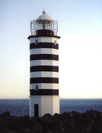
Mys Alevina Light, Olsky District
unattributed photo from Маяки CCCP
Severo-Evensky District Lighthouses
Mys Matugan (Ostrov Rechnaya Matuga)
Date unknown. Probably inactive; listed with focal plane 62 m (203 ft); white light, 1.5 s on, 3.5 s off. 6 m (20 ft) square skeletal tower carrying a black rectangular daymark. No photo available but Bing has a satellite view. Located on a small island off Cape Matugan marking the east side of the entrance to the Shelikhov Gulf, the northeastern extension of the Sea of Okhotsk. Accessible only by boat. Site status unknown. Admiralty M8028; NGA 15553.

Omsukchansky District Lighthouses
Mys Nadezhda
Date unknown. Active; focal plane 140 m (459 ft); white light, 1.5 s on, 3.5 s off. 6 m (20 ft) square skeletal tower carrying a black and white rectangular daymark. No photo available and Google has only a distant satellite view of the cape. Located on a prominent cape on the west side of the Gizhiginskaya Bay, a northeast extension of the Sea of Okhotsk. Site status unknown. Admiralty M8026; NGA 15553.05.

Eastern Olsky District Lighthouses
Mys Ostrovnoy
Date unknown. Active; focal plane 52 m (171 ft); white flash every 4 s. 6 m (20 ft) square skeletal tower carrying a black and white rectangular daymark. No photo available and the small tower is not seen in Bing's satellite view. Not to be confused with another Mys Ostrovnoy lighthouse in Eastern Primorsky Krai. Located on a prominent cape on the west side of the Gizhiginskaya Bay about 80 km (50 mi) southwest of Mys Nadezhda. Site status unknown. Admiralty M8022; NGA 15553.15.
Mys Alevina (Mys Alevika)
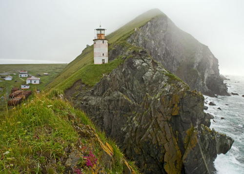
1958. Active; focal plane 58 m (190 ft); white light, 3 s on, 4.5 s off. 19 m (62 ft) octagonal cylindrical concrete tower with lantern and gallery, painted with black and white horizontal bands. Several 1-story station buildings. A photo is at the top of this page and Google has a satellite view of the station. Located on a promontory at the southwestern tip of the Koni Peninsula, marking the eastern entrance to the Tauyskaya Gulf, which leads to Magadan. Site status unknown. ARLHS ASR-011; Admiralty M8021; NGA 15560.
Mys Taran
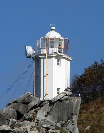
1958. Active; focal plane approx. 40 m (131 ft); three white flashes every 15 s. Approx. 15 m (49 ft) octagonal cylindrical brick tower with lantern and gallery, painted with red and white horizontal bands. 5th order Fresnel lens. Several 1-story station buildings. A distant view is at right, Lightphotos.net has a photo and a closeup by Sergey Karpukhin, Vladimir Lomovtsev has a view from the sea, and Google has a satellite view of the station. Note: There is another Mys Taran lighthouse in Kaliningrad on the Baltic Sea. Located on a very sharp cape at the northwestern tip of the Koni Peninsula. Site status unknown. Admiralty M8015; NGA 15561.
 

Mys Taran Light, Olsky District
photo by photogeographic.ru posted by Маяки CCCP
Mys Yuzhnyy (Ostrov Zavyalova Yuzhnyy)
Date unknown. Active; focal plane 217 m (712 ft); white flash every 3 s. 6 m (20 ft) octagonal cylindrical concrete tower painted white. No photo available but Google has a satellite view. Zavyalova is an island about 25 km (15 mi) long and 8 km (5 mi) wide located about 18 km (11 mi) west of Mys Taran. Located on the southwestern tip of Zavyalova Island. Accessible only by boat. Site status unknown. Admiralty M8010; NGA 15561.1.
Rassvet (Ostrov Zavyalova Severnyy)
Date unknown. Active; focal plane 35 m (115 ft); white flash every 4 s. 6 m (20 ft) octagonal cylindrical concrete tower painted white. No photo available but Google has a satellite view. Located on a promontory on the north coast of Zavyalova Island. Accessible only by boat. Site status unknown. Admiralty M8010.5; NGA 15561.12.
Ola
Date unknown. Active; focal plane 14 m (46 ft); red flash every 3 s. 12 m (39 ft) square cylindrical skeletal tower carrying a daymark painted with black and white horizontal bands. No photo available but Google has a satellite view. Located on an island in the approach to Ola, a town about 25 km (15 mi) east of Magadan. Accessible only by boat. Site open, tower closed. Admiralty M8013; NGA 15561.4.
Chirikova (Mys Chirikova) (2)
1957 (station established 1936). Active; focal plane 74 m (243 ft); white flash every 7.5 s. 14 m (46 ft) octagonal cylindrical tower with lantern and gallery. Entire lighthouse painted white. A photo is at right, a 2012 closeup and a distant view are available, Lighthouses USSR has a page for the light station, and Google has a distant 2020 street view and a satellite view. This lighthouse stands at the end of the Staritskiy Peninsula marking the south side of the entrance to the Bukhta Nagayeva and Magadan. The first lighthouse was a triangular pyramidal wood tower. The present lighthouse was repaired after being damaged by a severe storm in October 1972. Located about 30 km (19 mi) west southwest of Magadan. Site status unknown; there appears to be road access to the station. . ARLHS ARS-142; Admiralty M8011; NGA 15562.
Mys Chirikova Light
Mys Chirikova Light, September 2005
City of Magadan photo by Voldemar

Magadan City Lighthouses
* Bukhta Nagayeva Range Front (2)
1962 (station estabklished 1935). Active; focal plane 15 m (49 ft); continuous red light. 15 m (49 ft) octagonal masonry tower with gallery, attached to a 1-story equipment building. Lighthouse painted white with a black vertical stripe on the front face. Nina Bunchuzhnaya's photo is at right, Lighthouses of the USSR has a page for the range lighthouses, Evgeny Gutarev has a photo, Alexander Evgenievich Vyatkin has a 2020 street view, and Google has a satellite view. Founded in 1929 and built initially by convict labor, Magadan is the only town of any size in the province and one of the most isolated cities of the world. The city is located at the head of the Bukhta Nagayeva, a fjord-like bay, and this light is the front light of the range that guides ships up the bay to the harbor. Located on the shore of the bay just to the west of the city. Site appears open, tower closed. ARLHS ARS-141; Admiralty M8012; NGA 15562.2.
* Bukhta Nagayeva Range Rear
1962 (station estabklished 1935). Active; focal plane 43 m (141 ft); continuous red light. 14 m (46 ft) square concrete tower with gallery. Lighthouse painted white with a black vertical stripe on the front face. Lighthouses of the USSR has a page for the range lighthouses, Vitalia Cornoby has a closeup photo, Ivan Ivanov has a photo of the two range lights, and Google has a street view and a satellite view. Located 400 m (1/4 mi) east northeast of the front light, in an area of tall apartment towers. Site presumably open, tower closed. Admiralty M8012.1; NGA 15562.21.

Western Olsky District Lighthouses
Ostrov Spafaryeva (3)
1966 (station established 1941). Active; focal plane 87 m (285 ft); white light, 3 s on, 9 s off. 20 m (66 ft) round cylindrical cast iron tower painted with red and white horizontal bands. A photo is available, Yevgeniy Radchenko has a very distant view showing the lighthouse in action, and Google has a satellite view. The first light was replaced by a 10 m (33 ft) triangular wood tower in 1944. Spafaryeva Island is at the western entrance to the Tauyskaya Gulf, which leads to Magadan. The miltary base on the island is closed, but the settlement at the lighthouse houses the staffs of the light station and weather station. Located on the south coast of the island. Site status unknown. ARLHS ARS-155; Admiralty M8009; NGA 15564.
Beringa
Date unknown. Active; focal plane 12 m (39 ft); white flash every 3 s. 6 m (20 ft) octagonal cylindrical concrete tower painted white. A photo is available and Google has a satellite view. Located on a spit at the northwestern corner of Spafaryeva Island. Site status unknown. Admiralty M8009.5; NGA 15564.1.

Bukhta Nagayeva Range Front Light, Magadan, November 2019
Google Maps photo by Nina Bunchuzhnaya

Information available on lost lighthouses:

Notable faux lighthouses:

Adjoining pages: East: Kamchatka | Southwest: Northern Khabarovsk

Return to the Lighthouse Directory index | Ratings key

Posted May 19, 2006. Checked and revised July 8, 2024. Lighthouses: 13. Site copyright 2024 Russ Rowlett and the University of North Carolina at Chapel Hill.