Lighthouses of Russia: Eastern Black Sea

Russia (Россия, Rossiya in Russian) is by far the world's largest country, spanning a little over 150° in longitude. It is organized as the Russian Federation (Rossiyskaya Federatsiya) with members known as federal subjects (sub'yekty federatsii). Russia is primarily a continental nation but it has important coastlines on the Baltic, Black, and Caspian Seas and very long coastlines on the Arctic Ocean and North Pacific Ocean. To guard these coasts it operates hundreds of lighthouses, many of them historic.

Through its outlet to the Mediterranean the Black Sea has long provided a southern maritime connection for Russia. However, the history of Russia's control of the Black Sea coast is complex. Following the breakup of the Soviet Union in 1991 the Russian Federation's control of the Black Sea coast was limited to the area east of the Kerch Strait, which connects the Black Sea to the much smaller basin of the Sea of Azov.

This page includes lighthouses of the eastern Black Sea coast, between the Abkhazian border and the Kerch Strait. The largest city and principal port on this coast is Novorossiysk but the best known location is Sochi, the beach resort town that was the site of the Olympic Winter Games in 2014. Administratively this coast is part of Krasnodar Krai (often called Kuban), a large member of the Russian Federation including the western end of the Caucasus Mountains. This area was added to Russia in a long series of conflicts ending in 1864. Historically the coastal region was known as Circassia; Sochi was the traditional capital of Circassia.

The Russian word for a lighthouse is mayak (маяк); ostrov is an island, poluostrov is a peninsula, kosa is a sandy spit, rif is a reef, mys is a cape, bukhta is a bay, zaliv is a larger bay or gulf, proliv is a strait, reka is a river, and gavan' is a harbor.

Russian lighthouses are owned by the Russian Navy and maintained by the Office of Navigation and Oceanography (Управление навигации и океанографии).

ARLHS numbers are from the ARLHS World List of Lights. RU numbers, where available, are from the Russian Black Sea light list (publication 2217). Admiralty numbers are from volume N of the Admiralty List of Lights & Fog Signals and U.S. NGA List numbers are from Publication 113.

General Sources
Lighthouses in Krasnodar Krai
Photos by various photographers available from Wikimedia.
World of Lighthouses - Black Sea Coast of Russia
Photos by various photographers available from Lightphotos.net.
Online List of Lights - Black Sea - Russia
Photos by various photographers posted by Alexander Trabas.
Russische Leuchttürme auf historischen Postkarten
Historic postcard images posted by Klaus Huelse.
Navionics Charts
Navigation chart for the Black Sea.


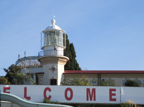
Mys Tolstyy Light, Gelendzhik, May 2021
Google Maps photo by Alex Gavrilov
Sochi City Lighthouses
Often called the Caucasian Riviera, this coast is Russia's most popular seaside resort area.

* Imeretinsky Range Common Rear
2012. Active; focal plane 21 m (69 ft); yellow light, 1.5 s on, 1.5 s off. 15 m (49 ft) round cylindrical metal tower, painted white with a red vertical stripe. Dmitry Kvitkevich has a photo, Cyril Sobolev has a photo, and Google has a street view and a satellite view. The two front lights are the lights on the breakwaters of the harbor, seen in another Google street view. These lights guide vessels to a new port developed in Adler prior to the Sochi Winter Olympics of 2014. Located at the south end of Golubaya Boulevard in front of the Imeretinsky Hotel. Site open, tower closed. Admiralty N5699.51; NGA 19166.1.
Imeretinsky Severnyy
2012. Active; focal plane 25 m (82 ft); green flash every 1.5 s. 30 m (98 ft) square cylindrical skeletal tower painted red with a white horizontal band. Google has a street view and a satellite view. Located on the quay, a short distance west of the Olympic Stadium. Site status unknown. Admiralty N5699.5; NGA 19165.
* Adler (Mys Adlerskiy) (4?)
2006 (station established 1898). Active; focal plane 13 m (43 ft); two yellow flashes every 8 s. 12 m (33 ft) round cylindrical metal tower with gallery, painted white with narrow red horizontal bands. A 2019 photo and a closeup are available and Google has a street view and a satellite view.This lighthouse replaced a skeletal tower; the older lighthouse stood for several years but has been removed. Adler is a resort town at the southeastern tip of the Russian Black Sea coast, less than 5 km (3 mi) from the Abkhazian border. This is sometimes called Russia's southernmost lighthouse, but that title belongs to the Derbent lighthouse on the Caspian Sea. Located on the waterfront of Adler. Site open, tower closed. ARLHS ERU-294; RU-2320; Admiralty N5698; NGA 19164.
* Matsesta Passenger Pier
Date unknown. Active; focal plane about 17 m (56 ft); red light, pattern unknown. Approx. 12 m (39 ft) round tower with a large gallery and lantern structure. Vitaly Panichev has a drone view and Google has a satellite view. Located on the pier at Matsesta, about 40 km (25 mi) southeast of Sochi. Probably accessible by walking the pier. Site open, tower closed. Admiralty N5693.
* Sochi (Range Front) (2)
1890 (station established 1880). Active; focal plane 37 m (121 ft); green light, 1.5 s on, 1.5 s off. 15 m (49 ft) cylindrical tower with lantern and gallery, rising from one corner of a large 1-story keeper's house. Lighthouse painted white. The original 2nd order L. Sautter Fresnel lens remains in use. A photo is at right, Vlad Feoktistov has a 2009 photo, Yuliya Bazhenova has a 2016 photo, the lighthouse appears at the left in a photo of an amusement park (the Mayak Aquapark) on the Sochi waterfront, Huelse has a historic postcard view, Vadim Korchagin has a street view, and Google has another street view and a satellite view. Sochi, near the southeastern end of Russia's Black Sea coast, has the warmest climate in Russia and is a very popular resort; it was also the site of the Winter Olympics in 2014. This historic lighthouse is located just to the east of the port area in Sochi but it is surrounded by modern development and seems mostly forgotten. Site probably open, tower closed. ARLHS ERU-063; Admiralty N5686; NGA 19132.

Sochi Light, Sochi, October 2014
Wikimedia Creative Commons photo by Gray Gray
Sochi Yuzhniy (South Mole)
Date unknown. Active; focal plane 13 m (43 ft); green flash every 2 s. 10 m (33 ft) square pyramidal skeletal tower with gallery, painted green. Lightphotos.net has a 2000 photo and Google has a satellite view. Located at the end of the south (really east) mole of the inner harbor at Sochi. Site status unknown, probably closed. Admiralty N5690; NGA 19148.
Sochi Severniy (North Mole)
Date unknown. Active; focal plane 20 m (66 ft); red flash every 2 s. 16 m (52 ft) round masonry tower with lantern and gallery; the light is now displayed from atop the lantern. Lighthouse painted red with one white horizontal band. John Honeywell's photo is at right, Lyubov Glazkova has a photo, Lightphotos.net has a closeup by Oleg Sushkov, Alexey Chernyshev has a nice view from the sea, and the lighthouse can be seen in a Google satellite view. Located at the end of the so-called north mole, the breakwater on the west side of the inner harbor at Sochi. Site status unknown, probably closed. Admiralty N5689; NGA 19140.
* Sochi Mid-Channel Range Rear
2014 (?). Active; focal plane about 30 m (98 ft); light characteristic unknown. Approx. 26 m (85 ft) round cylindrical metal tower painted red. The tower has "wing" extensions along its sides as a daymark. Idi Smotri has a sea view and Google has a street view and a satellite view. The front light is on a similar but smaller tower on the center of a detached breakwater off the harbor entrance. Located near the base of the new outer breakwater enclosing Sochi harbor. Admiralty N5688.91.
* Mys Uche-Dere
Date unknown. Active; focal plane 25 m (82 ft); white flash every 2 s. 22 m (72 ft) skeletal mast atop a 6-story waterfront building. Vardan Elbakyan has a photo, and Google has a satellite view. Located on a point of land near Dagomys, about 16 km (10 mi) northwest of Sochi. Site open, tower closed. Admiralty N5685; NGA 19130.
Lazarevskoye
Date unknown. Active; focal plane 96 m (315 ft); white light, 1.5 s on, 4.5 s off. 14 m (46 ft) triangular skeletal tower. The front of the tower is covered with a large slatted daymark painted white with a red (although NGA says black) vertical stripe. A distant street view from the Psezuapse River Bridge is available and Google has an indistinct satellite view. Located on heights above Lazarevskoye, a resort town about 30 km (19 mi) northwest of Sochi. Site status unknown. Admiralty N5684; NGA 19128.
Sochi Severniy Light
Sochi Severniy Light, Sochi, May 2007
Flickr photo copyright John Honeywell; used by permission

Tuapse District and City Lighthouses
Tuapse is a seaport town of about 65,000 residents. It is the terminal of an oil pipeline from Grozny, Chechnya, and has an oil refinery and oil shipment facilities.

Ashe
Date unknown. Active; focal plane 49 m (161 ft); white flash every 3 s. 43 m (141 ft) square cylindrical tower. The nature of this building is not known. Wikipedia has a photo and Bing has a satellite view. Located on the waterfront, beside railroad tracks, about 20 km (13 mi) southeast of Tuapse. Site status unknown. Admiralty N5682; NGA 19126.
Tuapse East Mole (2)
Date unknown (station established 1901). Active; focal plane 11 m (36 ft); green flash every 3 s. Approx. 9 m (30 ft) square pyramidal skeletal tower, lower third enclosed, mounted on a large 1-story square concrete base. Tower painted green with a white horizontal band. No photo available but Google has an indistinct satellite view. Located at the end of the east breakwater mole of Tuapse. May be accessible by walking the mole. Site status unknown. RU-2262; Admiralty N5670; NGA 19112.
* Tuapse Novyy Port Range Front
Date unknown. Active; focal plane 19 m (62 ft); continuous blue and green lights, the blue one above the green one. 17 m (56 ft) square pyramidal skeletal tower with lantern and gallery. Tower painted black, lantern white. The front of the tower carries a large trapezoidal slatted daymark, painted white with a black vertical stripe. No photo available but Google has a distant street view and an indistinct satellite view. The rear light is probably similar but it is shorter. Located at the water's edge on the Tuapse waterfront. Site open, tower closed. RU-2245; Admiralty N5674; NGA 19120.
Tuapse Novyy Port Range Rear
Date unknown. Active; focal plane 37 m (121 ft); continuous red, blue and green lights in a vertical array. 11 m (36 ft) square skeletal tower. No photo available but Google has a satellite view. Located on a steep hill 274 m (300 yd) north of the front light. Site status unknown. Admiralty N5674.1; NGA 19124.
 
Tuapse West Mole (Tuapse Yugozapadnyy Volonolom) (2)
Date unknown (station established 1909). Active; focal plane 13 m (43 ft); red flash every 3 s. Approx. 10 m (33 ft) square pyramidal skeletal tower, lower third enclosed, mounted on a large 1-story square concrete base. Tower painted red with a white horizontal band. No photo available but Google has an indistinct satellite view. Located at the end of the west mole of Tuapse, which is the principal breakwater for the port. Site status unknown. RU-2250; Admiralty N5672; NGA 19116.
Kodosh (Mys Kodosh, Kodoshskiy, Tuapse)
1885. Active; focal plane 62 m (203 ft); two white flashes every 14.2 s. 14 m (46 ft) octagonal cylindrical masonry tower with lantern and gallery, rising from the front of a masonry keeper's house. Lighthouse painted white. A photo is at right, Wikimapia has a closeup, Wikimedia as a distant view, Lightphotos.net has an excellent closeup photo and Google has a satellite view of the station. This appears to be the original lighthouse. Located on a promontory about 3 km (2 mi) west of the waterfront of Tuapse. Site status unknown. ARLHS ERU-043; Admiralty N5668; NGA 19108.
Dzhubga (Dzubga) (3)
1954 (station established 1898). Active; focal plane 11 m (36 ft); one long red flash every 6 s. Approx. 8 m (26 ft) square cylindrical brick tower with lantern and gallery, rising from the front of a 1-story brick keeper's house. Lighthouse painted white except that the lantern and the front face of the tower are painted red. A 2021 drone view is available, Wikimapia has a distant sunset photo and Google has a satellite view. The original light, a small wood tower, was replaced in 1906 by a small iron tower. The design of the present lighthouse is similar to that of the Gollwitz Nord lighthouse, built about the same time in the former East Germany. Located on a headland on the east side of Dzhubga, about 35 km (22 mi) northwest of Tuapse. Site open, tower closed. Admiralty N5666; NGA 19100.

Mys Kodosh Light, Tuapse, November 2017
unsigned photo posted to zen.yandex.ru

Gelendzhik City Lighthouses
Gelendzhik is a resort town of about 65,000 residents located about 30 km (19 mi) southeast of Novorossiysk.

Drovyanaya Shchel' Range Front
Date unknown. Active; focal plane about 14 m (46 ft); red light, pattern unknown. Approx 10 m (33 ft) round cylindrical tower with an expanded upper portion. Maxim Popach has a drone view of the range and Google has a satellite view of the two range lights. These lights mark the Russian end of an undersea natural gas pipeline that crosses the Black Sea to Turkey. Located on the waterfront at the mouth of a valley in a wild area northwest of Dzhubga. Site status unknown. Admiralty N5665.
Drovyanaya Shchel' Range Rear
Date unknown. Active; focal plane about 20 m (66 ft); red light, pattern unknown. Approx 15 m (49 ft) round cylindrical tower with an expanded upper portion. Maxim Popach has a drone view of the range and Google has a satellite view of the two range lights. Located about 50 m (165 ft) northeast of the front light. Site status unknown. Admiralty N5665.01.
Arkhipo-Osipovka (Arkhipka)
2009. Active; focal plane approx. 30 m (98 ft); white flash every 3 s. Approx. 9 m (30 ft) round cylindrical white metal or fiberglass tower. Google has a closeup street view and an indistinct satellite view. Located on the steep slope of a headland on the west side of Arkhipo-Osipovka, a seaside resort about 50 km (30 mi) southeast of Gelendzhik. Site open, tower closed. Admiralty N5664.8; NGA 19090.
Mys Tolstyy (Gelendzik Headland) (2?)
Date unknown (station established 1899). Active; focal plane about 55 m (180 ft); two white flashes every 15 s. 42 m (138 ft) octagonal concrete tower with lantern and double gallery, painted white with three red horizontal bands. Alex Gavrilov's 2021 photo is at the top of this page, Wikimedia has a photo, another photo and a third photo are available, and the lighthouse can be seen in a Google street view and satellite view. NGA formerly listed a round 12 m (39 ft) tower at this location. Huelse has a postcard view of an earlier lighthouse, a very small tower. In 1904 the light was listed with a focal plane of 17 m (56 ft). The elliptical bay of Gelendzhik is an especially scenic location on Russia's Black Sea coast. Located atop a chalk bluff on the cape at the east side of the entrance to Gelendzhikskiy Bukhta (bay), about 5 km (3 mi) south of Gelendzhik. Site and tower reported closed, but the lighthouse can be seen from nearby. ARLHS ERU-030; Admiralty N5656; NGA 19076.
* Gelendzhik (Stvornyy) (Range Front)
1897. Active; red or green light, depending on direction; light pattern unknown. Approx. 12 m (39 ft) square cylindrical masonry tower attached to one corner of a 2-story masonry keeper's house. Lighthouse painted white with a red vertical stripe indicating a range line. Pavel Berdnikov has the 2017 photo also seen at right, Sergey Ivanov has a photo, Klaus Huelse has a historic postcard view, and Google has a street view and a satellite view. The lighthouse was designed by the French architect François de Tonde. This was originally the front light of a range, but the range has been discontinued. Located on Lermontovskiy Boulevard near the waterfront in downtown Gelendzhik. Site open, tower closed. Admiralty N5658.

Stvornyy Light, Gelendzhik, August 2017
Google Maps photo by Pavel Berdnikov

Novorossiysk City Lighthouses
Novorossiysk is Russia's principal port on the Black Sea and a major naval base. Its magnificent bay was the location of an ancient Greek colony, a Genoese colony during the Middle Ages, and an Ottoman fortress that was ceded to Russia in 1829. The population of the city is about 340,000.
Doobskiy (Mys Doobskiy, Doob Point)
1879. Active; focal plane 100 m (328 ft); three white flashes every 16.5 s. 23 m (75 ft) octagonal masonry tower with lantern and gallery, painted white. Nautophone fog signal (3 blasts every 20 s). 1-1/2 story rubblestone keeper's house. Ahadxon Ibragimov has a 2018 photo (also seen as right), Iriska Kiska has a closeup photo, Oksana Kokokha has a 2019 closeup, Ivan Mironov has a 2022 photo, Dmitry Molotkov has a photo, Wikimedia has a series of views from the sea, and Google has a satellite view. Located on Mys Doobskiy (Cape Doob), marking the east side of the entrance to Novorossiyskaya Bukhta (Novorossiysk Bay), about 5 km (3 mi) southwest of Kabardinka. Site status unknown. ARLHS ERU-029; Admiralty N5636; NGA 18984.
Mys Penay Range Front
Date unknown. Active; focal plane 33 m (108 ft); green light, 1.5 s on, 1.5 s off. 20 m (66 ft) square skeletal tower carrying a daymark painted white with a red vertical stripe. No photo available but Google has a satellite view. This is the approach range for Novorossiysk. Located on a headland on the east side of Novorossiysk Bay. Site and tower closed. Admiralty N5638; NGA 19000.
Mys Penay Range Rear
Date unknown. Active; focal plane 59 m (193 ft); green light, 1.5 s on, 1.5 s off. 10 m (33 ft) square skeletal tower carrying a daymark painted white with a red vertical stripe. Google has a street view and an indistinct satellite view. Located above the M-4 expressway 425 m (1/4 mi) north of the front light. Site and tower closed. Admiralty N5638.1; NGA 19004.
Novorossiysk East Mole Range Front
Date unknown. Active; focal plane 24 m (79 ft); two green lights, one above the other, 3 s on, 3 s off. 21 m (69 ft) round 2-stage concrete tower with lantern and gallery. Upper stage painted white with red horizontal bands. Lantern painted red. Sergey Kotov has a good photo, Ivan Vakorin has a closeup 2018 photo, Maria Lebedeva has a street view from the West Mole. and Google has a satellite view. This is the entrance range for Novorossiysk. Located at the end of the east mole of the inner harbor of Novorossiysk. May be accessible by walking the pier. Site status unknown. Admiralty N5642; NGA 19024.
Novorossiysk East Mole Range Rear
Date unknown. Active; focal plane 74 m (243 ft); green light, 4.5 s on, 1.5 s off. 14 m (46 ft) square concrete tower painted white with a red vertical stripe. Google has a street view and a satellite view. Located on heights in the city 2.85 km (1.78 mi) northwest of the front light. Site and tower closed. Admiralty N5642.1; NGA 19028.

Doobskiy Light, Novorossiysk, January 2018
Google Maps photo by Ahadxon Ibragimov
* Novorossiysk West Mole
Date unknown. Active; focal plane 12 m (39 ft); red flash every 3 s. 8 m (26 ft) concrete tower with gallery. Lighthouse painted red with one white horizontal band. A good closeup and a 2021 photo are available, Slavka Pletnikov has a photo, Maria Lebedeva has a street view, and the light can be seen in a Google satellite view. Located at the end of the west breakwater protecting the harbor of Novorossiysk. Accessible by walking the mole, but it's a long walk as the breakwater is about 1.6 km (1 mi) long. Site open, tower closed. Admiralty N5644; NGA 19032.
* Lyubvi (Mys Lyubvi)
Date unknown. Active; focal plane 20 m (66 ft); continuous red light. 15 m (49 ft) square tower rising at one end of 2-story building. Google has a street view and a satellite view. Located on Mys Lyubvi (Love Point), a point of land on the west side of Novorossiyskaya Bukhta (bay), about 1.5 km (1 mi) southeast of the Novorossiysk harbor area. Site open, tower closed. RU-2055; Admiralty N5643; NGA 19016.
Sudzhukskaya (Sudzhukskiy, Kosa Sudzhukskaya)
Date unknown. Active; focal plane 12 m (39 ft); two red flashes every 10 s. 13 m (43 ft) round concrete tower with gallery, mounted on a square concrete pier. The lighthouse is unpainted white concrete. Dan Romanov's photo is at right, a 2023 photo and a distant view are available but the light is not shown in Google's satellite view. Located on a shoal on the west side of the entrance to Novorossiyskaya Bukhta (Novorossiysk Bay), about 2.5 km (1.5 mi) southeast of Aleksino. Accessible only by boat. Site open, tower closed. ARLHS ERU-148; Admiralty N5639; NGA 18980
* Reka Ozereevskiy (Ozereyevsky River)
Date unknown. Active; focal plane 24 m (79 ft); two flashes every 6 s, white or red depending on direction. 10 m (33 ft) square cylindrical skeletal tower painted black and carrying a white rectangular daymark. Google has a street view and a satellite view. Located beside a main street in South Ozereyevka. Site open, tower closed. Admiralty N5633; NGA 18976.
Mys Utrishenok (Range Front) (2)
Date unknown. Active; focal plane 13 m (43 ft); one long white flash every 7 s. 12 m (39 ft) skeletal mast. The post carries a slatted daymark painted white with a black vertical stripe. A 2021 photo is available, the light is at the left of Dmitriy Lyapkalo's panoramic view, and Google has a satellite view. The first light was on a steel post mounted on a square 1-story masonry base. Located on a promontory projecting into the sea in a mountainous area about 30 km (19 mi) west of Novorossiysk. Site status unknown. Admiralty N5632.5; NGA 18972.

Sudzhukskaya Light, Novorossiysk, July 2013
Google Maps photo by Dan Romanov
Mys Utrishenok Range Rear
Date unknown. Inactive. Approx. 15 m (49 ft) steel post mounted on a square 1-story masonry base. The post carries a slatted daymark painted white with a black vertical stripe. Ruslan Delavshok has a street view, the light is at the right edge of Oleg Strelnikov's photo, and Google has a satellite view. Located about 300 m (0.2 mi) northeast of the active light. Site status unknown.

Anapa District and City Lighthouses
Anapa is a beach resort town very popular among Russians but not often visited by tourists from other countries. Its population is about 90,000.

Utrish (Ostrov Utrish) (2)
Date unknown (probably 1920s; station established 1911). Inactive. Approx. 7 m (23 ft) hexagonal cylindrical cast iron tower with lantern and gallery. Lighthouse painted white; lantern painted blue. Boris Shmarkovsky's photo is at right, a September 2016 photo shows that the little lighthouse had been beautifully restored, Igor Grenovetsky has a 2021 photo, Alexander Zobenko has a 2017 street view, and Google has a satellite view. The lighthouse formerly appeared to be abandoned and deteriorating. Utrish is an island and nature preserve just off a cape about 16 km (10 mi) southeast of Anapa. Located on the western tip of the island. Accessible only by boat. Site open, tower closed.
Utrish (Ostrov Utrish) (3)
Date unknown (station established 1911). Active; focal plane 26 m (85 ft); white light, 1.5 s on, 1.5 s off. 17 m (56 ft) round cylindrical masonry tower with gallery; there is a band of sculptured faces around the tower about 1/4 the way up. Boris Shmarkovsky's photo is at right, Pavel Gubin has a 2007 photo, Lightphotos.net has a closeup photo, and Google has a street view and a satellite view. The lighthouse is unpainted gray masonry; the small lantern is red. The bas-relief circling the base of the tower is a memorial to fishermen who were killed during World War II. Both Utrish lighthouses were restored in 2016. Located close to the original lighthouse on the western tip of the island. Accessible only by boat. Site open, tower closed. . ARLHS ERU-009; Admiralty N5632; NGA 18964.

Old and new Ostrov Utrish Lights, September 2020
Google Maps photo by Boris Shmarkovsky
** Anapa (Mys Anapskiy) (2)
1955 (station established 1909). Active; focal plane 44 m (144 ft); red light, 3 s on, 3 s off, 3 s on, 6 s off. 20 m (66 ft) octagonal cylindrical masonry tower with lantern and gallery. Lighthouse painted white with black horizontal bands only on the seaward side. Artem Topchiy's photo is at right, Pavel Gubin has a photo of the lighthouse in action, Pavel Romanov has a 2016 closeup photo, Georgiy Kuskov has a nighttime street view, Igor Osadchiy has a daytime street view, and Google has a satellite view. Huelse has a postcard view of the very elegant original lighthouse and Lightphotos.net has a second postcard view. The historic lighthouse was destroyed in 1943 during World War II. According to the web site of Sanitorium Mayak (a nearby spa resort), the lighthouse is "serving as a museum," so it is probably open for climbing. Located on a seaside bluff on the south side of Anapa. Site open, tower probably open but details are not available. . ARLHS ERU-295; Admiralty N5618; NGA 18944.
* Anapa Range Front
Date unknown. Active; focal plane about 11 m (36 ft); light characteristic unknown. Approx. 10 m (33 ft) square skeletal tower painted black and mounted on a square white concrete base. Den Gavrilin has a drone view and Bing has a satellite view. Located on the beach northwest of the historic lighthouse. Site open, tower closed. Admiralty N5619.
Anapa Range Rear
Date unknown. Active; focal plane about 22 m (72 ft); light characteristic unknown. Approx. 20 m (66 ft) square skeletal tower painted black and mounted on a square white concrete base. Google has a street view and Bing has a satellite view. Located beside a pond about 500 m (1.3 mi) east of the front light. Site status unknown but the light is easy to see from Severnaya Ulitsa (North Street). Admiralty N5619.1.
Kubanskiy (2?)
Date unknown. Active; focal plane 30 m (98 ft); white flash every 6 s. Approx. 11 m (36 ft) square cylindrical skeletal tower with lantern and gallery. The light is at the upper right corner in Vadim Dzheparov's photo, Vadim Shmelev has a very distant view, and Bing has a distant satellite view. NGA descibe a "red round metal column." Located on a bluff above the beach near the end of the Bugazskaya Spit, about 16 km (10 mi) northwest of Anapa. Site status unknown. Admiralty N5617.2; NGA 18941.

Information available on lost lighthouses:

Notable faux lighthouses:


Anapa Light, Anapa, September 2007
Wikimedia Creative Commons photo by Artem Topchiy

Adjoining pages: North: Sea of Azov | East: Abkhazia | West: Eastern Crimea

Return to the Lighthouse Directory index | Ratings key

Posted February 26, 2007. Checked and revised August 30, 2023. Lighthouses: 44. Site copyright 2023 Russ Rowlett and the University of North Carolina at Chapel Hill.