Lighthouses of Russia: Northern Sakhalin

Russia (Россия, Rossiya in Russian) is by far the world's largest country, spanning a little over 150° in longitude. It is organized as the Russian Federation (Rossiyskaya Federatsiya) with members known as federal subjects (sub'yekty federatsii). Russia is primarily a continental nation but it has important coastlines on the Baltic, Black, and Caspian Seas and very long coastlines on the Arctic Ocean and North Pacific Ocean. To guard these coasts it operates hundreds of lighthouses, many of them historic.

Sakhalin, located just off Russia's east coast, is the country's largest island, stretching 950 km (almost 600 mi) from north to south and separating the Sea of Japan to the southwest from the Sea of Okhotsk to the northeast. Sakhalin and the Kuril Islands together form an oblast (province), one of the members of the Russian Federation.

Both Japan and Russia became interested in annexing these territories during the mid 1800s. In 1875 the Treaty of St. Petersburg assigned Sakhalin to Russia and the Kurils to Japan, and within a few years Russia began building lighthouses in Sakhalin. In 1905, at the end of the Russo-Japanese War, Russia was obliged to cede the southern half of Sakhalin to Japan, the border being fixed at 50° north latitude. Russia took control of all of the island in 1945, near the end of World War II. Japan renounced its former claims to Sakhalin in the 1951 Treaty of San Francisco.

This page describes lighthouses in the northern half of the island, the region that has always been administered by Russia.

Sakhalin Island is divided into 14 districts and one independent city (Yuzhno-Sakhalinsk).

The Russian word for a lighthouse is mayak (маяк); ostrov is an island, poluostrov is a peninsula, kosa is a sandy spit, rif is a reef, mys is a cape, bukhta is a bay, zaliv is a larger bay or gulf, proliv is a strait, reka is a river, and gavan' is a harbor.

Russian lighthouses are owned by the Russian Navy and maintained by the Office of Navigation and Oceanography (Управление навигации и океанографии).

Special thanks to Alexander Barkov for the use of his photos on this page.

ARLHS numbers are from the ARLHS World List of Lights. Admiralty numbers are from volume M of the Admiralty List of Lights & Fog Signals. U.S. NGA List numbers are from Publication 112.

General Sources
Sakhalin Lighthouses
Overview (in Russian) and selected photos by Igor Samarin of the Sakhalin Regional Museum in Yuzhno-Sakhalinsk.
Lighthouses of the USSR - Far Eastern Seas
This Russian-language reference provides valuable historical information.
Russian Lighthouse Society
Photos and information on many lighthouses.
World of Lighthouses - Far East of Russia
Photos available from Lightphotos.net.
Online List of Lights - Russia - Pacific Coast
Photos by various photographers posted by Alexander Trabas.
Idilesom.com - Sakhalin - Lighthouses
Photos collected by a tourist development site.
Russische Leuchttürme auf historischen Postkarten
Postcard views of historic Russian lighthouses posted by Klaus Huelse.
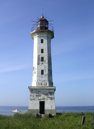

Mys Marii Light, Sea of Okhotsk, July 2008
ex-Panoramio photo copyright Alexander Barkov
used by permission

Central West Coast (Tartar Gulf) Lighthouses

Sakhalin is separated from the mainland on the south by the Tartar Gulf, an arm of the Sea of Japan, and on the north by Amur Bay, an arm of the Sea of Okhotsk. Amur Bay and Tartar Gulf are joined at Lazarev by a narrow passage called the Nevel'skogo (Nevelskoy) Strait. These waterways are known collectively as the Tartar Strait.

Smirnykh District West Coast Lighthouse
Mys Korsakova (2)
Date unknown. Inactive; listed with focal plane 102 m (335 ft); white flash every 6 s. 17 m (56 ft) square cylindrical skeletal tower; the upper 2/3 is enclosed by a slatted daymark painted white. Sergey Manakin has a closeup 2018 street view, Alexey Loshkarev has a distant view, and Google has a satellite view. Not to be confused with the better known Korsakov lighthouse in Southern Sakhalin. Mys Korsakova is a tombolo: a small island connected to the mainland of Sakhalin by a narrow isthmus. The lighthouse stands at latitude 50° 01.2' north, so it is only 2.2 km (1.4 mi) north of the border with Japan before World War II. Located on the highest point of this peninsula, about 45 km (28 mi) north of Boshnyakovo. Site status unknown. Admiralty M7706; NGA 0162.

Alexandrovsk-Sakhalinsky District Lighthouse
* Zhonkier (Mys Zhonkier) (2)
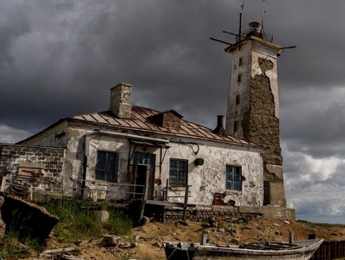
1897 (station established 1886). Active (?); focal plane 79 m (259 ft); one long white flash every 33 s. 18 m (59 ft) octagonal cylindrical stone tower with lantern and gallery, attached to the seaward end of a ruined 1-story stone keeper's house. Entire lighthouse painted white; the lantern dome is a metallic green. 1st order Fresnel lens still in use. Tkachuk Artyom has a photo from the steep slope above the lighthouse (also seen at right), a 2017 closeup and a panoramic view are available, Alexey Andrushenko has a closeup photo showing a small reserve light next to the lighthouse, Boris Udalov has a lovely view of the cape, the Lighthouse Society has a page for the lighthouse, Huelse has a historic postcard view, and Google has a satellite view. Sakhalin's first light station was established in 1860 at Mys Due, 6 km (3.5 mi) south of Mys Zhonkier. The first, temporary lighthouse had a focal plane of 88 m (290 ft). It was replaced in 1864 with a lighthouse having a focal plane of 114 m (374 ft). This proved to be much too high, causing the light to be moved in 1886 to Zhonkier, a cape named in 1787 by the French explorer La Pérouse in honor of his patron the Marquis de la Jonquière. The lighthouse guided ships to the Alexandrovsky Station, now the town of Alexandrovsk-Sakhalinsky. Located about 100 km (60 mi) north of the 1905 line dividing Russian and Japanese territory, Alexandrovsk was the Soviet Union's main base in Sakhalin in the 1930s and during World War II. Sadly, the historic lighthouse is now gravely endangered by a failing foundation; photos show giant cracks in the building. Apparently this was caused by uncontrolled quarrying of gravel lower on the slope. The 125th anniversary of the light station was celebrated in July 2011. Located on a promontory about 3 km (2 mi) southwest of Alexandrovsk-Sakhalinsky. Site open, tower closed. ARLHS ASR-078; Admiralty M7700; NGA 15744.

Mys Zhonkier Light, Alexandrovsk-Sakhalinsky, August 2007
Google Maps photo by Tkachuk Artyom

Okha District (Northern Sakhalin) Lighthouses

Nevel'skoy Strait Lighthouses
The Nevel'skoy Strait is a narrow passage connecting the Amur Bay with the Tartar Gulf to the south. It is named for Capt. Gennady Nevel'skoy, who sailed through the strait in 1849, proving to westerners that Sakhalin is an island. At its narrowest the strait is only 7.3 km (4.5 mi) wide. Under Stalin the Soviet government planned a railroad tunnel under the strait and actually began construction, but the project was abandoned after Stalin's death in 1953. In 2018 President Putin commissioned a study of building a bridge over the strait.

Mys Uangi Range Front
Date unknown. Active; focal plane 15 m (49 ft); white light, 2 s on, 2 s off. 11 m (36 ft) octagonal cylindrical concrete tower, painted white with a black vertical stripe on the range line. No photo available but Google has a distant satellite view. This southbound range is the southernmost of three ranges that guide vessels through the narrowest passage of the strait. Located on a promontory north of Druzhba, at the south end of the strait. Site status unknown. Admiralty M7686; NGA 15744.6.
Mys Uangi Range Rear
Date unknown. Active; focal plane unknown; white light, 2 s on, 2 s off. 21 m (69 ft) skeletal tower. No photo available but Google has a distant satellite view. Located 369 m (0.23 mi) south southeast of the front light. Site status unknown. Admiralty M7686.1; NGA 15744.61.
Pogibi Yuzhnyy (South Pogibi) Range Front
Date unknown. Active; focal plane 19 m (62 ft); red flash every 3 s. 11 m (36 ft) octagonal cylindrical concrete tower; the front of the tower is painted painted white with a black vertical stripe on the range line. The tower is at the far left in Sergey Lysov's photo and Google has an indistinct satellite view. This is a northbound range. Pogibi is a small settlement opposite Cape Lazarev in Khabarovsk; between the two towns is the narrowest passage of the strait, about 7.3 km (4.5 mi) in width, seen in a photo by Evgenia Stukalova. Located on a promontory in Pogibi. Site status unknown. Admiralty M7685.2; NGA 15744.53.
Pogibi Range Common Rear
Date unknown. Active; focal plane 39 m (128 ft); red flash every 3 s for the south range; continuous red light for the north range. 26 m (85 ft) skeletal tower. Roma Kravchenko has a photo and Google has an indistinct satellite view. Located 742 m (0.46 mi) northeast of the Pogibi Yuzhnyy front light and 1392 m (0.87 mi) southeast of the Pogibi Severnyy front light. Site status unknown. Admiralty M7685.1; NGA 15744.52.
Pogibi Severnyy (North Pogibi) Range Front
Date unknown. Active; focal plane 17 m (56 ft); red light, 1.5 s on, 1.5 s off. 11 m (36 ft) octagonal cylindrical concrete tower; the front of the tower is painted white with a black vertical stripe on the range line. Sergey Lysov's photo is at right, Alexander Konakov has a March 2018 closeup, Wikimapia has a distant photo (click on the center thumbnail), and Google has a satellite view. Located about 1.5 km (1 mi) northwest of the Pogibi Yuzhnyy Front Light. Site status unknown. Admiralty M7685; NGA 15744.51.

Pogibi Severnyy Range Front Light, Pogibi, 2012
ex-Panoramio Creative Commons photo by Sergey Lysov

Amur Bay (Rybnovsk Area) Lighthouses
The Amur Bay (Gulf of Amur) is an irregular basin about 120 km (75 mi) long and roughly 30 km (19 mi) wide, connecting the Sakhalin Gulf to the north with the Nevel'skoy Strait to the south. In Russian it is called the Amurskiy Liman; although the geographic term liman is usually translated "estuary" or "lagoon" "bay" seems more appropriate in this case. The bay is relatively shallow, with many shoals, so it is not easy to navigate.
Valuyevskiy (Mys Rybnovsk) Range Front (3)
1962 (station established 1940). Active; focal plane 20 m (66 ft); red flash every 4 s. 15 m (49 ft) square concrete tower with lantern and gallery, attached to a 1-story keeper's house. One of Alexander Barkov's photos is at right, he has a 2006 closeup, Felix Achkasov has a 2017 photo, Samarin has a historic photo, and Google has a satellite view. It appears that the lighthouse was repaired in 2011. but a 2021 photo shows it in very poor condition. This is a range guiding northbound vessels approaching the Sakhalin Gulf from the Amur Bay. The original range lighthouses were poorly built and their foundations crumbled; they were demolished in 1953 and replaced by temporary wood towers in 1955. Located on the beach about 3 km (2 mi) south of Rybnovsk. Site probably open, tower closed. Admiralty M7680; NGA 15744.26.
Valuyevskiy (Mys Rybnovsk) Range Rear (3)
1962 (station established 1940). Active; focal plane unknown; continuous red light. 28 m (92 ft) square skeletal tower. No photo available but Google has a satellite view of the tower. Located 928 m (0.58 mi) northeast of the front light. Site status unknown. Admiralty M7680.1; NGA 15744.27.
Vereshchaginskiy Range Front (3)
1964 (station established 1938). Active; focal plane 15 m (49 ft); red light, 2 s on, 3 s off. 12 m (39 ft) octagonal cylindrical concrete tower, painted white with a black vertical stripe on the range line. No photo available but Google has a satellite view. This range guides southbound vessels entering the Amur Bay. The original range lights were on triangular pyramidal wood towers. They were replaced with taller wood towers in 1953. Located on the beach about 3 km (2 mi) north of Rybnovsk. Site probably open, tower closed. Admiralty M7679.5; NGA 15744.2.
Vereshchaginskiy Range Rear (3)
1964 (station established 1938). Active; focal plane unknown; red light, 2 s on, 3 s off. 30 m (98 ft) skeletal tower. No photo available but Google has a satellite view. Located 556 m (0.35 mi) southeast of the front light. Site status unknown. Admiralty M7679.51; NGA 15744.21.
Petumboppovskiy Range Front
Date unknown. Active; focal plane 20 m (66 ft); white flash every 3 s. 16 m (52 ft) octagonal cylindrical concrete tower, painted white with a black vertical stripe on the range line. No photo available but Google has a satellite view. This is another southbound range. Located about 8 km (5 mi) north of Rybnovsk. Site probably open, tower closed. Admiralty M7679.4; NGA 15584.45.
Petumboppovskiy Range Rear
Date unknown. Active; focal plane unknown; continuous white light. 29 m (95 ft) skeletal tower. No photo available but Google has a satellite view. Located 2222 m (1.38 mi) southeast of the front light. Site status unknown. Admiralty M7679.41; NGA 15584.46.
Valuyevskiy Range Front Light
Valuyevskiy Range Front Light, Rybnovsk, 2011
ex-Panoramio photo copyright Alexander Barkov
used by permission
Moskal'vo Area (Baykal Bay) Lighthouses
Baykal Bay (Zaliv Baykal) is a lagoon about 20 km (13 mi) in diameter near Okha in northern Sakhalin; it is connected to the Sakhalin Gulf by two narrow inlets. These lights guide vessels to the port of Moskal'vo, built to support oil exploration in the Sea of Okhotsk.

Mys Vnutrenniy
1974 (?). Active; focal plane 9 m (30 ft); white light, 1.5 s on, 1.5 s off. 9 m (30 ft) round metal tower painted with black and white horizontal bands. Aleksandr Podlesnykh has a photo and Bing has a satellite view. Located on the west side of the entrance to Baykal Bay and Moskal'vo, about 10 km (6 mi) south of Mys Vkhodnoy. Accessible only by boat. Site status unknown. Admiralty M7904; NGA 15589.
Zaliv Baykal First Leg Range Front/ Third Leg Range Rear
1974. Active; the First Leg Front light has focal plane 31 m (102 ft); white light, 1.5 s on, 1.5 s off; and on the same tower the Third Leg Rear light has focal plane 32 m (105 ft); red light, 1.5 s on, 1.5 s off. 28 m (92 ft) square cylindrical skeletal tower. No photo available but Google has a satellite view. Located on the northeast side of the entrance to the bay. Site status unknown. Admiralty M7909.99.
Mys Moskal'vo (Zaliv Baykal First Leg Range Rear)
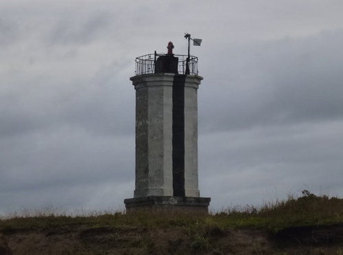
1974. Active; focal plane 41 m (135 ft); white light, 1.5 s on, 1.5 s off. 35 m (115 ft) round cylindrical cast iron tower painted white with a black vertical stripe. A photo is at right and Google has a satellite view. Located 556 m (0.35 mi) east of the front light. Site status unknown. Admiralty M7910; NGA 15585.
Zaliv Baykal Third Leg Range Front
1974. Active; focal plane 23 m (75 ft); red light, 1.5 s on, 1.5 s off. 15 m (49 ft) square cylindrical skeletal tower. No photo available but Google has a satellite view. Located on the coast about 650 m (0.4 mi) south of the First Leg Front Light. Site status unknown. Admiralty M7910.3.
Zaliv Baykal Second Leg Range Front
1974. Active; focal plane 16 m (52 ft); green light, 2 s on, 2 s off. 9 m (30 ft) square cylindrical skeletal tower. No photo available but Google has a satellite view. Located on the east side of the entrance to the bay, about 10 km (6 mi) south of Mys Vkhodnoy. Site status unknown. Admiralty M7910.4.
Zaliv Baykal Second Leg Range Rear
1974. Active; focal plane 21 m (69 ft); green light, 2 s on, 2 s off. 13 m (43 ft) square cylindrical skeletal tower. No photo available but Google has a satellite view. Located on the east side of the entrance to the bay, about 10 km (6 mi) south of Mys Vkhodnoy. Site status unknown. Admiralty M7910.41.

Mys Moskal'vo Light, Moskal'vo
unattributed photo posted by Lighthouses of the USSR

Sea of Okhotsk Lighthouses
The northeastern tip of Sakhalin projects into the Sea of Okhotsk and ends with two capes, Cape Mary on the west and Cape Elizabeth on the east. The two capes are like "ears" at the head of a peninsula about 80 km (50 mi) long.

Mys Marii (Cape Mary) (2)
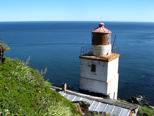
1961 (station established 1933). Active; focal plane unknown; white flash every 6 s. 18 m (59 ft) octagonal stone tower with lantern and gallery, mounted on a square stone base. A small drum-style Fresnel lens is in use. Lighthouse painted white, lantern red. Alexander Barkov's photo is at the top of this page, he has a second photo, another page for the lighthouse has several photos, and Google has a wintry satellite view. The lights on the two capes were built as part of plan launched in 1929 to strengthen navigation and defense in northern Sakhalin. The original light was on a 11.5 m (38 ft) pyramidal wood tower. The cape was discovered by a Russian expedition in 1805 and named for the mother of Tsar Alexander I and widow of Tsar Paul I. Located at the point of the cape. Accessible only by boat. Site open, tower closed. ARLHS ASR-130; Admiralty M7679; NGA 15587.
Mys Yelizavety (Cape Elizabeth)
1935. Active; focal plane 73 m (240 ft); two white flashes every 15 s. 12 m (39 ft) square tower with lantern and gallery, rising from a 1-story brick keeper's house. Alexander Barkov's photo is at right, he also has a view of the station and the trail leading to the lighthouse, several photos have been posted on Twitter, and Bing has a satellite view. This lighthouse marks the northernmost tip of Sakhalin. The cape was discovered by a Russian expedition in 1805 and named for the wife of Tsar Alexander I. Located at the point of the cape. Site status unknown. ARLHS ASR-076; Admiralty M7902; NGA 15588.
Mys Yelizavety Light
Mys Yelizavety Light, Sea of Okhotsk, July 2008
ex-Panoramio photo copyright Alexander Barkov; used by permission
Pil'tun (2)
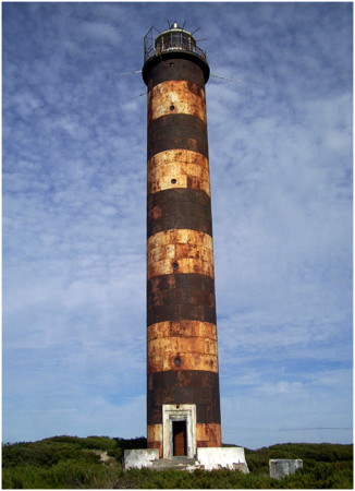
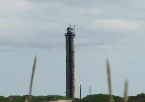
1964 (station established 1949). Active; focal plane about 38 m (125 ft); white light occulting once every 7.5 s. 35 m (115 ft) round cylindrical cast iron tower with lantern and gallery, painted with black and white horizontal bands. Fresnel lens in use. This is a staffed station, with four wood keeper's houses, two in use by keepers and one available for visiting scientists. One of Alexander Barkov's photos is at right, he also has a view of the station, Lightphotos.net has Oksana Savenko's 2012 photo, and Google has a satellite view. The original lighthouse was a 23.5 m (77 ft) wood skeletal tower. Endangered. Jake Levenson visited in August 2009 and has an extreme closeup and a photo taken inside the lantern room. According to Levenson the lighthouse was damaged by an earthquake sometime before 2002. The photos show that it is rusted and in need of major maintenance. Located on the west side of the Pil'tun lagoon about 1.4 km (7/8 mi) from the Sea of Okhotsk on the remote northeastern coast of Sakhalin about 185 km (115 mi) south of Cape Elizabeth. Accessible only by boat. Site and tower restricted. Admiralty M7902.5; NGA 0195.

East Coast (Sea of Okhotsk) Lighthouses

Nogliki District Lighthouses
Zaliv Chayvo (2)
1968 (station established 1949). Active; focal plane 28 m (92 ft); white flash every 6 s. 24 m (79 ft) octagonal concrete tower with lantern and gallery. Upper third of the lighthouse painted black, lower 2/3 white. Google has a satellite view. The original lighthouse was a square wood skeletal tower. Located on the north side of the entrance to a lagoon (Chayvo Bay) about 65 km (40 mi) southwest of the Piltun lighthouse. Accessible only by boat. Site status unknown. Admiralty M7920; NGA 0195.5.
Nyyvo
1968. Active; focal plane 27 m (89 ft); white flash every 3 s. 12 m (39 ft) round concrete tower, painted with black and white horizontal bands. An Idilesom.com page for the lighthouse has several photos and Google has a satellite view of the station. Located on the north side of a lagoon entrance northeast of Nogliki on the central east coast of Sakhalin. Site status unknown. Admiralty M7930.
 
Pil'tun Light
Pil'tun Light, Sea of Okhotsk, 2011
ex-Panoramio photo copyright Alexander Barkov
used by permission
#Nabil' (4)
1982 (station established 1949). Collapsed due to beach erosion in June 2000. This was a 10 m (33 ft) round cylindrical concrete tower, painted with black and white horizontal bands. No photo available and no tower is seen in Google's satellite view. The original lighthouse here was unique: a 33.5 m (110 ft) octagonal wood tower with lantern and gallery. It was lost to beach erosion in 1969. The light was moved atop a station building and then atop a second station building in 1973. All these structures were eventually lost to the sea. Located on the south side of the entrance at the north end of the Nabilskiy lagoon about 15 km (9 mi) southeast of Nogliki. Site status unknown. ex-Admiralty M7886.
Mys Ratmanova (2?)
Date unknown. Active; focal plane 40 m (131 ft); white flash every 3 s. 12 m (39 ft) round cylindrical concrete tower painted with red and white horizontal bands. NGA describes the light as a skeletal tower but it appears solid in Bing's satellite view. No photo available. Located on a sharp promontory in a very remote area of Sakhalin's east coast. Site status unknown. Admiralty M7890; NGA 0194.

Smirnykh District East Coast Lighthouse
Mys Nizkiy
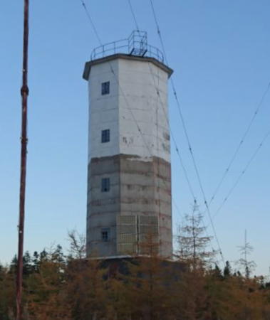
1968. Active; focal plane 22 m (72 ft); white flash every 8 s. 17 m (56 ft) octagonal cylindrical concrete tower with lantern and gallery. Upper half of the lighthouse painted white, lower half originally painted red (a recent photo, no longer online, showed the lower half of the tower faded to a dull tan). Alexey Peshkov has the 2019 photo at right and Google has a satellite view. NGA misspells the name as "Nizkig." The lighthouse stands at latitude 50° 01.0' north, so it is only 1.8 km (1.1 mi) north of the border with Japan before World War II. Located on a promontory about 160 km (100 mi) north northwest of Mys Terpeniya. Site status unknown. Admiralty M7885.1; NGA 0193.

Information available on lost lighthouses:

  • Mys Due (Douai) (1863-1876), about 10 km (6 mi) south of Mys Zhonlier. Lighthouses of the USSR discusses this lighthouse (first lighthouse on the page). The lighthouse was a 13 m (43 ft) square wood tower. It was replaced by the Zhonkier lighthouse.

Mys Nizkiy Light, Smirnykh District, September 2019
Google Maps photo posted by Alexey Peshkov

Notable faux lighthouses:

Adjoining pages: South: Southern Sakhalin | West: Northern Khabarovsk

Return to the Lighthouse Directory index | Ratings key

Posted May 8, 2006. Checked and revised March 4, 2023. Lighthouses: 27. Site copyright 2023 Russ Rowlett and the University of North Carolina at Chapel Hill.