Lighthouses of the United Kingdom: Eastern Scotland

The United Kingdom (officially the United Kingdom of Great Britain and Northern Ireland) includes England, Scotland, Wales, and Northern Ireland. Occupying the northern third of the island of Great Britain, the kingdom of Scotland has shared its monarch with England since 1603 and has been part of the United Kingdom since 1707. The coastline of the country is deeply cut by inlets, and there are more than 790 islands. The country has a long and distingushed maritime history; many of the most famous British captains and navigators have been Scots.

Scotland was divided historically into 34 counties; the counties no longer have any administrative function although they continue to have cultural significance. Since 1996 the country has been divided into 32 council areas for the purposes of local government. This page is for lighthouses of the North Sea coast of Scotland in the council areas of Moray, Aberdeenshire and Angus and the important port cities of Aberdeen and Dundee. Lighthouses of the southeast, including the Firth of Forth and its approaches, are listed on Southeastern Scotland page. The region covered by this page includes the great northeastern bulge of the coastline reaching to Rattray Head and Kinnaird Head.

The Scottish word loch is used both for lakes and for inlets of the sea; a firth is a larger bay or strait and a mull is a rounded headland. The Scottish Gaelic phrase for a lighthouse is taigh solais; eilean is an island, sgeir is a skerry or rock, and rubha or àird is a cape or promontory.

The Northern Lighthouse Board , established by an act of Parliament in 1786, manages the major lighthouses of Scotland and the Isle of Man. For five generations engineers of the Stevenson family created for the Board a network of elegant and durable lighthouses famous around the world. Most of these lighthouses remain in service today.

ARLHS numbers are from the ARLHS World List of Lights. Admiralty numbers are from Volume A of the Admiralty List of Lights & Fog Signals. U.S. NGA numbers are from Publication 114.

General Sources
Northern Lighthouse Board - Lighthouse Library
The Board's web site includes information and photos for many of the lighthouses.
Michael's List of Scottish Lighthouses
A comprehensive web site by Michael Spencer.
Lighthouse Archives
Lighthouse information from LighthouseAccommondations.uk.
Lighthouses on the East Coast of Scotland
Photos and information for the major lighthouses, posted by Bob Schrage.
Online List of Lights - Scotland
Photos by various photographers posted by Alexander Trabas.
United Kingdom Lighthouses
Aerial photos posted by Marinas.com.
 
Lighthouses in Scotland
Photos available from Wikimedia; many of these photos were first posted on Geograph.org.uk.
World of Lighthouses - Scotland
Photos by various photographers available from Lightphotos.net.
The Stevensons
The history of Scotland's remarkable family of lighthouse engineers.
Britische Leuchttürme auf historischen Postkarten
Historic postcard images posted by Klaus Huelse.
GPSNavigationCharts
Navigation chart for Scotland.
Navionics Charts
Navigation chart for Scotland.


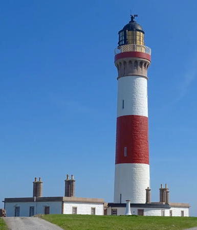
Buchan Ness Light, Boddam, February 2016
Wikimedia Creative Commons photo by Fred Coutts

Moray Lighthouses

The Moray council area faces north on Moray Firth, a broadly triangular embayment of the North Sea. This area was included in the historic counties of Morayshire and Banffshire.

Morayshire (Burghead and Lossiemouth) Lighthouses
* Burghead North Pier
1883. Active; focal plane 7 m (23 ft); white light, occulting once every 8 s. 6 m (19 ft) octagonal pyramidal white concrete tower topped by a small lantern. Lantern is red. Trabas has a good photo, Spencer has a photo, and Google has a street view and a satellite view. Located at the end of the pier in Burghead. Site open, tower closed. Operator: Moray Council (Burghead Harbour). ARLHS SCO-278; Admiralty A3424; NGA 2876.
** Covesea Skerries
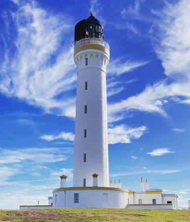
1846 (Alan Stevenson). Inactive since 2012. 36 m (118 ft) round masonry tower with lantern and gallery, painted white; lantern is black. Keeper's houses and other light station buildings preserved. The original Fresnel lens is on display at the Lossiemouth Fisheries and Community Museum. Vadder Pemm's photo is at right, Schrage has a good page for the lighthouse, LighthouseAccommodations also has a page, Wikimedia has additional photos, a YouTube video is available, Marinas.com has aerial photos, and Google has a beach view, a satellite view and a very distant street view. This historic lighthouse was deactivated in February 2012. A year later the Covesea Lighthouse Community Company, a local business group, received a grant of £301,000 from the Scottish Land Fund to purchase the light station from NLB. The sale was completed in April 2013. The keeper's house was opened for vacation accommodations in the summer of 2013. In June 2015 the Ministry of Defence announced a grant of £250,000 to acquire the land surrounding the lighthouse and develop visitor facilities. A new museum facility was built, the Covesea Lighthouse and Royal Navy and Royal Air Force Heritage Centre. The lighthouse was repainted in spring 2022. The skerries are small rocky islands off the south coast of Moray Firth, but the lighthouse is not on the skerries; it is built on Craighead, a promontory of the mainland near the islands. Located about 5 km (3 mi) west of Lossiemouth, just off the coastal road B9040. Site open, museum open Saturdays and Sundays April through October, tower open for guided tours Saturday mornings only April through October. Owner/site manager: Covesea Lighthouse Community Company . ARLHS SCO-053; ex-Admiralty A3414; ex-NGA 2860.
[Halliman Skerries]
1845. Inactive daybeacon. 12.5 m (41 ft) hexagonal iron skeletal tower topped by a round cage structure meant as a possible refuges for shipwrecked sailors awaiting rescue. Des Colhoun has a closeup photo and a more distant view, but the tower is not seen in Google's fuzzy satellite view. This beacon was built as part of the same project as the Covesea Skerries lighthouse. When the lighthouse was deactivated in 2012 the light was moved to a large buoy located off the east end of the Halliman Skerries. Located on the largest of the skerries about 1.6 km (1 mi) northeast of the Covesea Skerries lighthouse. Accessible only by boat, but easy to see from shore.
* Lossiemouth South Pier (2)
1902 (station established 1858). Active; focal plane 11 m (36 ft); red flash every 6 s. 11 m (36 ft) square skeletal tower with gallery and an enclosed lower section. Trabas has a photo, Aaron Williams has a closeup photo, Spencer has a photo, and Google has a street view and a satellite view. Located at the south side of the entrance to Lossiemouth harbor. Site open, tower closed. Operator: Lossiemouth Marina. Admiralty A3408; NGA 2856.
Covesea Skerries Light
Covesea Skerries Light, Lossiemouth, April 2010
Wikimedia public domain photo by Vadder Pemm

Banffshire (Buckie Area) Lighthouses
* Buckie North Pier (Range Rear, formerly Range Front) (2?)
1913. Active; focal plane 15 m (49 ft); red light, 7 s on, 3 s off. 15 m (50 ft) round stucco-covered stone tower with lantern and gallery, painted white. A photo by Anne Burgess is at right, another photo is available, Trabas has a photo, Marinas.com has aerial photos, Huelse has a historic postcard view, and Google has a satellite view and a distant street view. The Commission on Ancient and Historical Monuments has a page for the lighthouse. The pier was built in the 1870s, and the Jenkins 1904 light list includes a light on the pier. The light was originally the front light of a range with the Cliff Terrace light; since 2008 it is the rear light of a range with the front light on a post at the end of the pier. Located about 60 m (200 ft) from the end of the concrete breakwater sheltering the harbor of Buckie. Site open, tower closed. Operator: Moray Council (Buckie Harbour). ARLHS SCO-333; Admiralty A3394; NGA 2840.
* Buckie Cliff Terrace (ex-Buckie Range Rear)
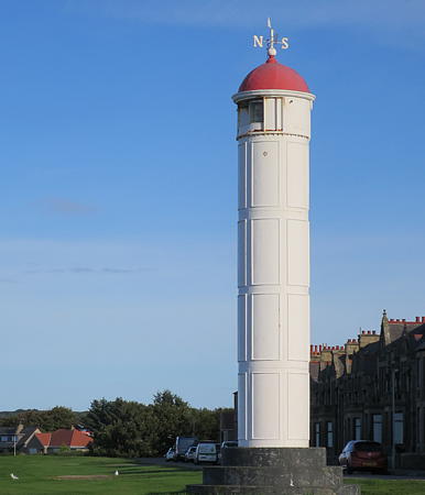
1878. Active; focal plane 20 m (66 ft); white or green light, depending on direction, 1 s on, 1 s off. 10 m (33 ft) round cylindrical cast iron tower with a domed roof; the light is shown through a rectangular window. Lighthouse painted white, dome red. Trabas has a good photo, Richard Kay has a twilight photo, and Google has a street view and a satellite view. This light and the north pier light (previous entry) are no longer used as a range. The tower was prefabricated by Munro & Co. in Dundee. Located on Cliff Terrace east of Cliff Street in Buckie. Site open, tower closed. Operator: Moray Council (Buckie Harbour). . Admiralty A3396.1; NGA 2844.
* Findocthy
1904. Inactive. 7 m (23 ft) round solid concrete tower topped by a 3 m (10 ft) round cast iron lantern. Lantern painted white. Spencer has a photo, Robin Wilson has a closeup photo, and Bing has a satellite view. The light was replaced by a pair of range beacons attached to lampposts. Findochty is pronounced "Finichty." Located on the west breakwater at Findochty, a small harbor halfway between Buckie and Cullen. Accessible by walking the pier. Site open, tower closed. Owner: Moray Council.
* Cullen (2)
About 1888 (station established 1866). Inactive. 4 m (13 ft) round cast iron tower, painted white. William Randle has a 2016 photo, Kyle Simpson has a 2014 photo, Craig Simpson has a 2008 photo, Marinas.com has aerial photos, and Google has a street view and a distant satellite view. Located on the east breakwater at Cullen, a village at the eastern edge of Moray. Accessible by walking the pier. Site open, tower closed. Owner: Moray Council. ARLHS SCO-284.
Buckie North Breakwater Light
Buckie North Pier Light, Buckie, June 2006
Geograph Creative Commons photo by Anne Burgess

Aberdeenshire Lighthouses

Aberdeenshire is a large council area at the northeastern corner of Scotland; its coastline faces north on Moray Firth and east on the North Sea. The council area includes the historic counties of Aberdeenshire and Kincardineshire and the easternmost part of Banffshire; the city of Aberdeen, on the North Sea coast, was included in historic Aberdeenshire but today it is a separate council area.

Banffshire (Banff Area) Lighthouses
* Portsoy Range Front (1)
1884. Inactive since 2009. Approx. 8 m (26 ft) round light tower with a round cast iron lantern house at one end of a rubblestone building. Lantern painted white. The light is shown from a 6th order Fresnel lens through a small window in the front of the lantern. Trabas has a photo, Marceline Smith has a view from a different angle, Spencer has a good photo, and Google has a street view and a satellite view. In 2009 the light (focal plane 12 m (39 ft); green flash every 4 s) was removed from the lantern and placed on a post, as seen in Spencer's photo. The rear light is mounted on a 4 m (13 ft) mast. The history of this light is unknown but it was apparently installed when the pier was rebuilt in 1884. Located on Shore Street on the waterfront of Portsoy, about 10 km (6 mi) west of Banff. Site open, tower closed. Operator: Aberdeenshire Council (Portsoy Harbour). ARLHS SCO-273; Admiralty A3368; NGA 2828.
* Whitehills (2)
1900. Active; focal plane 7 m (23 ft); flash every 3 s, white or red depending on direction. 7 m (23 ft) round lantern mounted atop a stone pierhead building. Lantern painted white, and the end of the pier is also painted white as a daymark. The modern light is mounted atop the lantern. Trabas has a photo, Spencer has photos, a 2014 photo is available, Google has a distant street view, and Bing has an indistinct satellite view. Located on the east breakwater at Whitehills, a small village about 5 km (3 mi) west of Banff. Site open, tower closed. Operator: Whitehills Marina. ARLHS SCO-256; Admiralty A3364; NGA 2824.
* Banff North Pier (Meavie Point) (3?)
1933 (station established 1832). Active; focal plane 8 m (26 ft); white flash every 4 s. 8 m (26 ft) round lantern mounted atop a stone pierhead building. Lantern and the front face of the pier painted white. The modern light is mounted atop the lantern. Trabas has a photo, Spencer has photos, and Google has a street view and a satellite view. The first light was on a mast. Located on the north breakwater at Banff. Site open, tower closed. Operator: Aberdeenshire Council (Banff Harbour). ARLHS SCO-268; Admiralty A3353.
* Macduff Pier
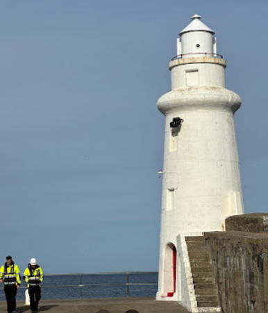
1905. Active; focal plane 12 m (39 ft); two flashes every 6 s, white, red, or green depending on direction. 11 m (36 ft) round stucco-covered stone tower with lantern and gallery, painted white. Fog horn (2 blasts every 20 s). John Lord's photo is at right, Trabas has a good closeup photo, Steve Brown has a photo, Tom Gardner has a fine closeup, Tina Wirkner has a great closeup, Spencer has photos, Marinas.com has aerial photos, and Google has a street view and a fuzzy satellite view. Located at the end of the concrete breakwater sheltering the harbor of Macduff, on Banff Bay. Site open, tower closed. Operator: Aberdeenshire Council (Macduff Harbour). . ARLHS SCO-272; Admiralty A3348; NGA 2812.

Macduff Pier Light, Macduff, July 2013
Flickr Creative Commons photo by John Lord

Fraserburgh Area Lighthouses
Fraserburgh is a fishing harbor and commercial port at the extreme northeastern tip of Scotland. The headland is rounded and marked by two major lighthouses, Kinnaird Head to the north and Rattray Head to the south.

* Rosehearty (Tam Pier)
1883. Reactivated (inactive 1960s-2008); focal plane 9 m (30 ft); white flash every 4 s. Approx. 7 m (23 ft) round cylindrical stone tower with gallery; the modern light is perched atop the tower. Lighthouse painted white. Trabas has a photo by Kees Aalbersberg, Spencer has photos, John Gault has a photo, a second photo is taken across the harbor, and Google has a street view and an indistinct satellite view. Spencer says the light was "discontinued by 1970." Located at the end of the west pier in Rosehearty, about 6 km (3.5 mi) west of Fraserburgh. Accessible by walking the pier. Site open, tower closed. Operator: Aberdeenshire Council (Rosehearty Harbour). Admiralty A3335.
**** Kinnaird Head (2)
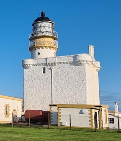
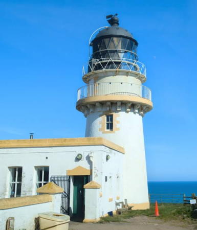
1824 (station established 1787). Inactive since 1991. Approx. 22 m (72 ft) structure, including a round cylindrical stone tower with lantern and gallery built atop a 16th century stone castle. The hyperradiant Fresnel lens (1902), larger than first order, is one of the largest lenses ever built. Tower painted white with buff trim; lantern painted black. The keeper's houses and other light station buldings have been converted into a lighthouse museum. A photo is at right, LighthouseAccommodations has a page for the museum and lighthouse, Schrage also has a fine page, Keith Bruce has a good closeup photo, Wikimedia has several photos, John Allan has a photo of both lights, Michelle Johnstone has a 2021 photo, Trabas also has a photo of both lighthouses, Nicholas Mutton has a photo of the fog signal, Huelse has a historic postcard view, Marinas.com has aerial photos, and Google has a street view and a satellite view. This was the first light station established by the Northern Lighthouse Board. The original tower was built in 1787 by Thomas Smith and then rebuilt in 1824 by his son-and-law Robert Stevenson, the founder of the Stevenson lighthouse dynasty. The museum has one of the world's largest collections of Fresnel lenses and lighthouse equipment. Located on a headland just northwest of Fraserburgh. Site open, museum and tower open daily except December 25-26 and January 1-2; also closed Mondays during the winter months. Owner: Kinnaird Head Trust. Site manager: Museum of Scottish Lighthouses . ARLHS SCO-113.
* Kinnaird Head (3)
1991 (station established 1787). Active; focal plane 25 m (82 ft); white flash every 5 s. 10 m (33 ft) round cylindrical fiberglass tower with lantern and gallery, painted white. John Allan has a photo of both lights, Michelle Johnstone has a 2021 photo, Trabas has a photo, Mike Sina has a street view, and Google has a satellite view. In 2019 NLB refurbished and upgraded the lighthouse. Located adjacent to the historic lighthouse. Site open, tower closed. Operator: Northern Lighthouse Board. Site manager: Museum of Scottish Lighthouses. ARLHS SCO-112; Admiralty A3332; NGA 2808.
Kinnaird Head Light
Kinnaird Head Light, Fraserburgh, September 2013
Wikimedia Creative Commons photo by Sagaciousphil
* Suther Ness (1) (relocated)
1904. Inactive. 5 m (16 ft) octagonal cast iron tower with lantern and gallery, painted white. LighthouseAccommodations has a photo (bottom of the page). The light originally guided ships into the harbor of Brough, on the island of Whalsay, Shetland. The relocated lighthouse stands outside the Museum of Scottish Lighthouses. Site open, tower closed.
Balaclava (Fraserburgh) Breakwater
1882. Active; focal plane 26 m (85 ft); two green flashes every 8 s. 21 m (69 ft) round stone tower with lantern and gallery mounted at the end of the concrete breakwater. Tower painted white with one narrow red horizontal band; lantern painted black. Fog siren (blast every 20 s) used only when fishing boats are expected. Keith Bruce has a good photo, Trabas has a photo, Chris Newman has a photo, Marinas.com has aerial photos, and Google has a street view and a satellite view. An elegant and well maintained pierhead lighthouse. Located at the end of the breakwater on the north side of the harbor at Fraserburgh. Site apparently open, tower closed. Operator: Fraserburgh Harbour Commission. ARLHS SCO-271; Admiralty A3312; NGA 2788.
Cairnbulg Briggs (Cairnbulg Point)
Date unknown. Active; focal plane 9 m (30 ft); white flash every 10 s. 10 m (33 ft) square skeletal tower with a large hexagonal skeletal lantern structure. Lighthouse painted red. Trabas has a photo, Spencer has a photo, Lighthouse Accommodations has a distant view, and Google has a distant satellite view of the location. The wreck of the fishing vessel Sovereign, which ran aground in December 2005, is next to the beacon. Located on a reef off Cairnbulg Point, a headland about 3 km (2 mi) east of Fraserburgh. Accessible only by boat. Site open, tower closed. Admiralty A3308; NGA 2784.
* Rattray Head
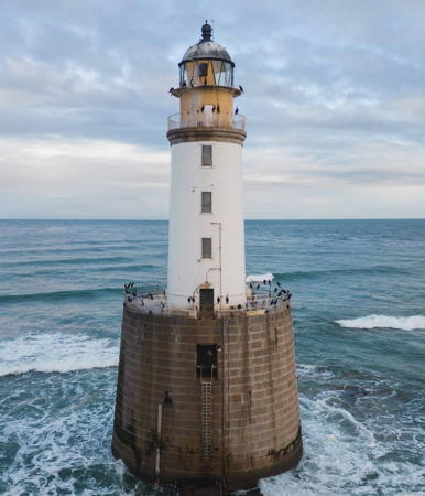
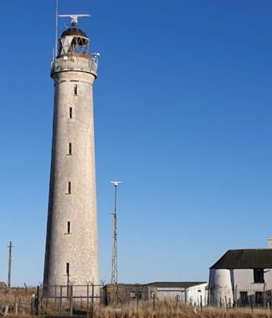
1895 (David A. Stevenson). Active; focal plane 28 m (92 ft); three white flashes, separated by 2.7 s, every 30 s. 34 m (112 ft), including a 20 m (66 ft) round brick tower with lantern and gallery atop a 14 m (46 ft) conical granite base. The granite is unpainted; the brick tower is painted white, the lantern black. Philip MacKenzie's photo is at right, Schrage has a good page for this lighthouse, LighthouseAccommodations also has a page for the lighthouse, Anne Burgess has a photo, a 2023 closeup and another good photo are available, Trabas has a photo by Arno Siering, Marinas.com has aerial photos, and Google has an indistinct satellite view. This lighthouse, located just off the beach, has an unusual design representing a compromise between onshore and offshore requirements. The onshore keeper's houses were used previously as a bed and breakfast inn and tearoom. In 2017 the light station was for sale for £490,000, and in 2018 it reopened as the Rattray Head Lighthouse Hostel. The light marks the northeastern "shoulder" of Scotland. Located about 13 km (8 mi) north of Peterhead and a similar distance southeast of Fraserburgh. Accessible by car on a long unsealed road. It is possible to walk to the lighthouse, with caution, at low tide. Site open, tower closed. Operator: Northern Lighthouse Board. Site manager: Rattray Head Lighthouse Hostel . ARLHS SCO-179; Admiralty A3304; NGA 2776.

Rattray Head Light, Peterhead, May 2021
Google Maps photo by Philip MacKenzie

Peterhead Area Lighthouses
Peterhead is a deepwater port used heavily to support the oil and gas rigs of the North Sea field; it is also Britain's largest fishing harbor. The city has a population of about 20,000.
* Peterhead Harbour South (relocated)
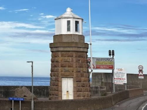
1849 (Thomas Stevenson). Inactive. 6 m (20 ft) octagonal stone tower with lantern. Tower unpainted, lantern painted white. John Best's photo is at right and Google has a 2021 street view and a satellite view. The light formerly stood on the Albert Quay at the south entrance to the inner basin but it was removed when Albert Quay was extended. The lighthouse was relocated in 2015 to the intersection of the Esplanade and Alexandra Parade on the north side of the harbor. Huelse has a historic postcard view of the light in service. Site open, tower closed. Owner/site manager: Aberdeenshire Council.
* Peterhead Harbour North (West Pier Elbow)
1908. Inactive since 2004 at least. 5 m (17 ft) octagonal stone tower with lantern. Tower unpainted, lantern painted white. Spencer has photos, and Google has a street view and a satellite view. This light is very poorly known; thanks to John Mobbs for bringing it to my attention. Huelse has a historic postcard view of the light in service. In 2017 the lantern was removed for restoration; it has been returned. Located in front of the Port Authority's control building, on the west pier at the entrance to the old inner basin of Peterhead. Site and tower closed but the light can be seen from nearby. Owner/site manager: Peterhead Port Authority. ARLHS SCO-282; ex-Admiralty A3291; ex-NGA 2760.
Peterhead South Breakwater
1912. Active; focal plane 24 m (78 ft); two red flashes every 12 s. 17 m (56 ft) round cast iron tower mounted a large circular concrete base at the end of the breakwater. Lantern removed. Lighthouse painted white with a black band at the base. A closeup photo is available, Trabas has a good photo, Spencer has a photo, Marinas.com has aerial photos, and Google has a satellite view. This is the easternmost lighthouse of mainland Scotland. Located at the end of the breakwater at Salthouse Head on the south side of Peterhead. Site and tower closed as far as is known. Operator: Peterhead Port Authority. ARLHS SCO-281; Admiralty A3284; NGA 2744.

Peterhead Harbour South Light, Peterhead, October 2017
photo copyright John Best; used by permission
* Buchan Ness
1827 (Robert Stevenson). Active; focal plane 40 m (131 ft); white flash every 5 s. 35 m (115 ft) round granite tower with lantern and gallery. The lighthouse is painted white with a broad red horizontal band around the center of the tower and a narrow red band around the gallery; lantern painted black. Keeper's houses and other light station buildings preserved. A photo by Fred Coutts is at the top of this page, Richard Slessor has a photo, Trabas has a good photo by Arno Siering, another fine photo is available, Wikimedia has several photos, LighthouseAccommodations has a good page for the lighthouse, Schrage also has a page, Marinas.com has aerial photos, Huelse has a historic postcard view, Google has a street view, and Bing has a satellite view. This lighthouse marks the easternmost point of the Scottish mainland, although it actually stands on a small island, linked to the mainland by a bridge. Mel Priest and his family bought the island in 2006. They have restored the keeper's cottages and in 2008 they opened the light station for holiday rentals. The lighthouse was restored in 2012-13 and LED optics were installed. Located at Boddam, about 6 km (4 mi) south of Peterhead. Site open, tower closed. Operator: Northern Lighthouse Board. Site manager: Buchan Ness Lighthouse Holidays . ARLHS SCO-024; Admiralty A3280; NGA 2740.

City of Aberdeen Lighthouses
* Aberdeen North Pier
1866. Active; focal plane 11 m (36 ft); green light (depending on direction), 4 s on, 2 s off; during fog a continuous yellow light is also shown from a focal plane of 10 m (33 ft). 9 m (30 ft) octagonal cast iron (?) tower with lantern and gallery, painted white. Fog horn (one short and one long blast: this is the Morse code "A" for Aberdeen). Bartolomeo Gorgoglione's photo is at right, Spencer has photos, Trabas has a photo, Jake McKenzie has a photo also showing the south breakwater light (see below), LighthouseAccommodations has a photo (third photo on the page), Marinas.com has aerial photos, and Google has a satellite view and a distant street view. The pier, 1000 m (3280 ft) in length, was built partly by John Smeaton in 1775-1781 and extended by Thomas Telford in 1810-1815. Located at the end of the breakwater on the north side of the entrance to the River Dee in Aberdeen. Site and tower closed. The lighthouse is easily visible from shore. Operator: Aberdeen Harbour Board. ARLHS SCO-276; Admiralty A3252; NGA 2700.

North Pier Light, Aberdeen, October 2012
Google Maps photo by Bartolomeo Gorgoglione
* Torry Range Front
1842. Active; focal plane 14 m (46 ft); continuous red light. 13 m (43 ft) octagonal cast iron tower, painted white. Trabas has Klaus Potschien's photo, Spencer has photos, and Google has a street view and a satellite view. This is the entrance range for Aberdeen. Huelse has a historic postcard view of the range lights. These range lights are thought to be the oldest cast iron lighthouses in service in the world. They were extended in height in 1886-87 and have been relocated short distances several times to match changes in the channel. According to Spencer the range lights were to be deactivated in 2013 in favor of a small directional light (A3261), but in view of their history it was decided to keep them operating. Located on Sinclair Road on the south bank of the River Dee in the Torry district of Aberdeen. Site and tower closed, but the light can be viewed from outside a fence. Operator: Aberdeen Harbour Board. ARLHS SCO-001; Admiralty A3258; NGA 2720.
* Torry Range Rear
1842. Active; focal plane 19 m (62 ft); continuous red light. 14 m (46 ft) octagonal cast iron tower, painted white. Trabas has Klaus Potschien's photo, Spencer has photos, and Google has a street view and a satellite view. Located on Sinclair Road on the south bank of the River Dee in the Torry district of Aberdeen, about 200 m (220 yd) southwest of the front light. Site open, tower closed. Operator: Aberdeen Harbour Board. ARLHS SCO-275; Admiralty A3258.1; NGA 2724.
Aberdeen South Breakwater
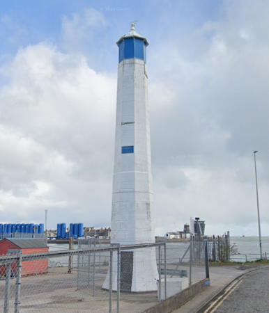
1866; breakwater built in 1815. Active; focal plane 22 m (72 ft); three red flashes every 8 s. Approx. 13 m (43 ft) round concrete tower with lantern and gallery, mounted on a conical concrete base at the end of the breakwater. Tower painted white. Mike Pennington's photo is at right, Neil Beaton has a closeup photo, Trabas has a photo, Marinas.com has aerial photos, Huelse has a historic postcard view, and Google has a street view and a fine satellite view. Located at the end of the breakwater on the south side of the entrance to the River Dee in Aberdeen, about 750 m (1/2 mi) northwest of Girdle Ness Light. Site and tower closed, although the lighthouse is easily visible from shore. Operator: Aberdeen Harbour Board. ARLHS SCO-277; Admiralty A3250; NGA 2704.

South Breakwater Light, Aberdeen, April 2010
Geograph Creative Commons photo by Mike Pennington
* Girdle Ness (Aberdeen)
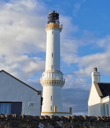
1833 (Robert Stevenson). Active; focal plane 56 m (184 ft); two white flashes, separated by 2.5 s, every 20 s. 37 m (121 ft) two-stage tower with lantern and gallery, painted white; lantern is black. About 1/3 of the way up the tower is a broad watch room with a window through which a second light was originally displayed; this lower light was discontinued in 1890. 1-story keeper's houses and other light station buildings. Adjacent to the lighthouse are two radio towers of the Differential Global Positioning System (DGPS), a satellite-based navigational service. The keeper's houses are privately owned and were reported for sale in 2004. Iain Lees's photo is at right, LighthouseAccommodations has a page for the lighthouse, Schrage also has a page, John Stewart has a fine 2008 closeup, Fred Fox (a former keeper) has posted his recollections of life at the station in 1973, Trabas has a photo by Arno Siering, Wikimedia has photos, Marinas.com has aerial photos, Huelse has a historic postcard view, and Google has a street view and a satellite view. This lighthouse originally displayed two lights, with the lower light on the lower gallery, a unique design in Scotland. The original lantern, too small for a first order lens, was transferred to Inchkeith Light near Edinburgh in 1847. In 2003 the Lighthouse Board announced its intention of removing the foghorn, which was discontinued in 1987. The Aberdeen City Council intervened and the foghorn, known locally as the Torry Coo, has been preserved. The principal keeper's house is available for vacation rental through Airbnb. Located on Greyhope Road, on a headland southeast of the entrance to the River Dee in Aberdeen. Site and tower closed, but the lighthouse can be viewed from outside the enclosure. Operator: Northern Lighthouse Board. . ARLHS SCO-089; Admiralty A3246; NGA 2696.
Girdle Ness Light
Girdle Ness Light, Aberdeen, August 2010
Geograph Creative Commons photo by Iain Lees

Kincardineshire Lighthouses
* [Stonehaven Range Rear]
Date unknown. Active; focal plane 8 m (26 ft); continuous red light. Light mounted on the side of a waterfront building. Building painted white. Trabas has a photo, Spencer has a photo and a second photo that shows the front light on a post across the street. Google has a street view and a satellite view of the location. This is the entrance range for the small village harbor. Located at 61 Shorehead on the Stonehaven waterfront. Site open. Operator: Aberdeenshire Council (Stonehaven Harbour). Admiralty A3240.1; NGA 2692.
Todhead (Tod Head) Point
1897 (David A. and Charles A. Stevenson). Inactive since 2007. 13 m (43 ft) round stone tower attached to a 1-story equipment building and 2-story keeper's house. Tower painted white with buff trim, lantern black. Alan Jamieson's photo is at right, LighthouseAccommodations has a page for the lighthouse, Stanley Howe has a photo, Wikimedia has photos, Graeme Davidson has a drone view, Marinas.com has aerial photos, Huelse has a historic postcard view, and Google has a satellite view and a very distant street view. The light station buildings are now privately owned. Located on a headland about 1.5 km (1 mi) south of Catterline and 8 km (5 mi) south of Stonehaven. Site and tower closed, although the lighthouse can be photographed from nearby. Owner/site manager: private. . ARLHS SCO-243; ex-Admiralty A3234; ex-NGA 2680.
* [Gourdon Range Front]
Date unknown (station established 1938). Active; focal plane 3 m (10 ft); continuous red light. Light mounted on the front wall of a warehouse. Trabas has a photo, Spencer has photos, and Bing has a satellite view of the location. Located at William and Bridge Streets in Gourdon. Site open. Admiralty A3228; NGA 2664.
* Gourdon Range Rear
1938. Active; focal plane 30 m (99 ft); continuous red light. 6 m (20 ft) round cylindrical brick tower with a conical roof; light shown through a window at the top of the tower. Tower painted white. Trabas has a photo, Lighthouse Digest has a photo by John Papp, Google has a street view, and Bing has a satellite view. Located on the south side of Queen Street, on the bluff above the harbor in Gourdon. Site open, tower closed. Operator: Aberdeenshire Council (Gourdon Harbour). ARLHS SCO-345; Admiralty A3228.1; NGA 2668.

Todhead Point Light, Stonehaven, April 2014
Wikimedia Creative Commons photo by Alan Jamieson

Angus and Dundee Lighthouses

Angus is a council area and former county on the central east coast of Scotland, north of the Firth of Tay. It adjoins Dundee, the fourth largest city in Scotland and an important port on the north bank of the Firth of Tay.

Montrose Area Lighthouses
Montrose is a town of about 12,000 residents at the northeastern corner of Angus.
Montrose Range Rear
1818. Active; focal plane 18 m (59 ft); continuous red light. 19 m (62 ft) brick tower with lantern and gallery, painted white; lantern painted bright red. Trabas has a photo, Alan Morrison has a view of the lighthouse and town, LighthouseAccommodations also has a photo (bottom of the page), Google has a street view from across the river, and Bing has a satellite view. Trabas also has a photo of the modern front light with the lighthouse appearing in the distance. Endangered: Spencer says this lighthouse is "badly neglected." It is in fact poorly known and rarely visited. This is the approach range guiding vessels past Scurdie Ness. Located on the north side of the entrance to the River South Esk in an area surrounded by commercial development, off Cobden Street near Ferry Road. Site open (there is parking adjacent to the lighthouse); tower closed. Operator: Montrose Port Authority. ARLHS SCO-336; Admiralty A3222.1; NGA 2644.
Montrose Inner Range Front
Date unknown. Active; focal plane 21 m (69 ft); continuous green light. 20 m (66 ft) square skeletal tower. The top of the tower carries a small orange triangular daymark. Trabas has a photo, Spencer also has a photo, and Bing has a satellite view. This is the entrance range for the harbor. Located near the east end of the quay on the south side of the river, off Brownlow Place. Site status unknown. Operator: Montrose Port Authority. Admiralty A3223; NGA 2648.
Montrose Inner Range Rear
Date unknown. Active; focal plane 33 m (108 ft); continuous green light. 32 m (105 ft) square skeletal tower. The top of the tower carries a small orange triangular daymark. Trabas has a photo, Spencer also has a photo, Google has a street view, and Bing has a satellite view. Located 180 m (590 ft) west of the front light. Site status unknown. Operator: Montrose Port Authority. Admiralty A3223.1; NGA 2652.
* Scurdie Ness (Scurdyness)
1870 (David and Thomas Stevenson). Active; focal plane 38 m (125 ft); three white flashes, separated by 2.5 s, every 20 s. 39 m (128 ft) stone tower with lantern and gallery. LED lamp installed in January 2018. Tower painted white, watch room buff, lantern buff with a black dome. Original keeper's houses and other light station buildings. A photo by Anne Burgess is at right, Schrage has a page for the lighthouse, LighthouseAccommodations also has a page, Trabas has Arno Siering's excellent photo, Allan Ogg has another good photo, Wikimedia has many photos, Huelse has a historic postcard view, Google has a street view, and Bing has a satellite view. A handsome and accessible lighthouse. The lighthouse celebrated its 150th birthday in 2020. Located at the point on the south side of the entrance to the River South Esk and the harbor of Montrose Basin, about 2 km (1.5 mi) east of Montrose. Accessible by a popular walking path from the end of Beacon Terrace (limited parking). Site open, tower closed. Operator: Northern Lighthouse Board. . ARLHS SCO-205; Admiralty A3220; NGA 2636.
Scurdie Ness Light
Scurdie Ness Light, Montrose, December 2007
Geograph Creative Commons photo by Anne Burgess

Bell Rock and Arbroath Lighthouses
* Arbroath East Pier
Date unknown (station established 1826). Active; focal plane 8 m (26 ft); green flash every 3 s. 9 m (30 ft) masonry building with lantern room. Entire structure painted white. Spencer has photos, Trabas has a closeup, and Google has a street view and a satellite view. Located at the end of the north breakwater pier in Arbroath. Accessible by walking the pier. Site open, tower closed. Operator: Angus Council (Arbroath Harbour). Admiralty A3216; NGA 2632.
*** [Arbroath Signal Tower]
1813 (Robert Stevenson). Approx. 20 m (66 ft) round cylindrical stone tower with a signal mast, attached to a 2-story keeper's house. Entire structure painted white. Johanna Summers has a 2022 photo, a good photo and a third photo are available, and Google has a street view and a satellite view. Until 1995 this elegant building was the shore station of the offshore Bell Rock Light, housing off-duty keepers and keepers' families. Today it is the local history museum, including displays on the lighthouse. In 2010 the museum received a £425,000 refurbishment. Located on Ladyloan Drive facing the harbor in Arbroath. Site open; museum open daily except Sundays; also open Sundays in July and August. Owner: Angus Council. Site manager: Signal Tower Museum .
Bell Rock
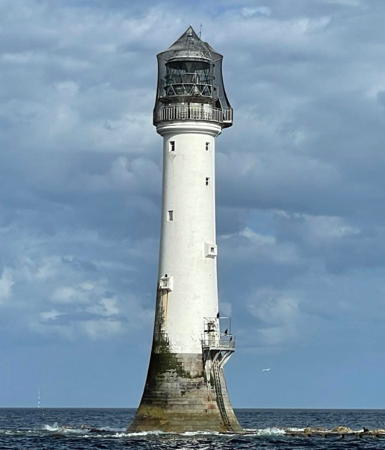
1811 (Robert Stevenson). Active; focal plane 28 m (92 ft); white flash every 5 s. 36 m (118 ft) tapered stone tower with lantern and gallery, incorporating keeper's quarters. Tower painted white with a brown band at the base; lantern painted black and covered by a bird-protecting mesh. Lynn Shellard's 2023 photo is at right, Schrage has a page for the lighthouse, LighthouseAccommodations also has a page, Trabas has a photo from followingthelights.com, Derek Robertson has a 2005 photo, John McMillan has a more distant photo, Huelse has a historic postcard view, David Taylor has a wonderful web site describing the construction and history of the lighthouse, Wikipedia also has an article on its history, and Bing has a satellite view. Bell Rock, also called Inchcape, is an extremely dangerous reef that barely breaks the surface at low tide. Construction of the lighthouse took four years and was justly considered one of the greatest triumphs of early nineteenth century engineering. The light remains the world's oldest waveswept tower and certainly one of its most famous lighthouses. A fire damaged the interior of the lighthouse during the 1990s although the damage was repaired. The tower was repaired and refurbished in 2010 in time for the celebration of its 200th anniversary in February 2011. In 2013-14 there was concern that a proposed massive windfarm could dwarf the historic lighthouse. There is also a shore station in Arbroath (previous entry). Located in the open North Sea about 19 km (12 mi) southeast of Arbroath. Accessible only by boat in very dangerous seas; visible at a great distance from Arbroath. Site and tower closed. Operator: Northern Lighthouse Board. . ARLHS SCO-020; Admiralty A3108; NGA 2616.

Bell Rock Light, North Sea, August 2023
Instagram photo by Lynn Shellard
* Vatsetter (Whitehill) (1) (relocated to Arbroath)
1904. Inactive. 4.5 m (15 ft) round cast iron lantern with gallery, painted red with white trim. Joe Brodie has a closeup photo, and Google has a street view and a satellite view. This lighthouse was originally installed on the east coast of the island of Yell in Shetland. It was stored after being replaced in 2001 by a modern structure and was placed on display at Arbroath sometime around 2010. Volunteers refirbushed and painted the tower in 2018. Located near a traffic roundabout on the A92 highway, welcoming travelers at the southern edge of Arbroath. Site open, tower closed. ex-Admiralty A3824.

Buddon Ness Lighthouses
Buddon Ness Low (3)
1866 (David and Thomas Stevenson). Station established 1688. Inactive since 1943. 20 m (66 ft) round brick and stone tower with lantern and gallery. This endangered lighthouse was painted white originally, but only traces of the paint remain. Keeper's house in ruins. Schrage has a good page for the lighthouses, Gwen and James Anderson have a closeup photo, Huelse has a historic postcard view showing both range lighthouses, and Google has a satellite view. Buddon Ness is the southern tip of the Barry Links, a wedge-shaped sandy promontory at the northern entrance to the Firth of Tay south of Carnoustie. Lighting the point usefully is a problem due to the rapidly shifting channels in the area. The original (1688) lighthouse was replaced in 1753 by a wooden low light built on rollers for ease of relocation. In 1884 the current tower was also relocated, hauled by a steam engine over greased wooden rails a distance of 63 m (207 ft) northeast. This engineering feat, remarkable for its time, is the earliest known instance of a masonry lighthouse being relocated in one piece. Today the Sands are marked only by a small beacon (Admiraly A3129.5) and buoys mark the channels offshore. Long used for military training, the area is closed to the public. Owner: Forth Ports PLC. Site manager: Ministry of Defense. ARLHS SCO-283.
Buddon Ness High (3)
1866 (David and Thomas Stevenson). Station established 1688. Inactive since 1943. Approx. 27 m (90 ft) round brick and stone tower with lantern and gallery, painted white originally, but only traces of the paint remain. A radar beacon operated by Forth Ports is mounted on the tower. 2-story Victorian keeper's house. A circular storeroom attached to the keeper's house is probably the base of the second (1753) lighthouse. Richard Webb's photo is at right, Schrage has a good page for the lighthouses, Ian Whitelaw has a 2022 photo, Wojciech Suszko has a 2010 closeup photo, Elliott Simpson has a 1986 photo, Huelse has a historic postcard view, Bobby Friel has a street view, and Google has a satellite view. Endangered. The lighthouse was for many years the common rear light for both inbound and outbound ranges. After deactivation the lighthouse served for some years as an observation post and for several years after 1987 it carried a radar scanner as part of a Dundee University research project. Located at the southern tip of the Barry Links, marking the entrance to the Firth of Tay. Site and tower closed. Owner: Forth Ports PLC. Site manager: Ministry of Defense. ARLHS SCO-025.
Buddon Ness High Light
Buddon Ness High Light, Carnoustie, August 2009
Geograph Creative Commons photo by Richard Webb

City of Dundee Lighthouse and Lightship

* King William IV Dock (Dundee Middle Pier, Telford Lighthouse) (relocated)
Date unknown (station established 1837). Inactive since the 1960s(?). 7 m (23 ft) round cylindrical stone tower with lantern. The tower is unpainted, lantern painted white. The lighthouse originally stood on the King William IV Dock in Dundee but the dock was demolished when the Tay Road Bridge (A92) was built (1963-66). The lighthouse was relocated to a park just west of the bridge near the Dundee Hilton Hotel. In November 2010 the tower was relocated a second time; it now stands on the waterfront just west of the bridge. Brian Shearey has a 2018 photo and Google's satellite view and 2015 street view show the new location. A historic postcard view posted by Huelse shows the lighthouse at its original location. Site open, tower closed. Owner/site manager: Dundee City Council. ARLHS SCO-368.
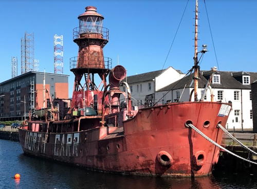
* NLB Lightship North Carr
1932. Decommissioned 1975. Steel lightship, length 30.8 m (101 ft), beam 7.6 m (25 ft); 10 m (33 ft) square pyramidal skeletal light tower, upper portion enclosed, with lantern. Entire ship painted red. A Fresnel lens from the ship is on display at the Museum of Scottish Lighthouses in Fraserburgh. Craig Glenday has the May 2021 photo at right, Lighthouse Accommodations has a page for the lightship, and Google has a 2020 street view and a satellite view. This is the only surviving Northern Lighthouse Board lightship. Except for wartime interruptions and maintenance, the ship served its entire career on the North Carr station off Fife Ness and the entrance to the Firth of Tay. Gravely endangered. In recent years the ship was moored at Dundee as a headquarters and depot ship for the Maritime Volunteer Service. In 2004-05 the ship was repainted at a cost of £55,000. In 2009 the Service decided to end its ownership and the Dundee maritime charity Taymara bought it for £1. In 2016 Taymara launched a £1 million fundraising campaign for a thorough restoration, but Criag Glenday's photo at right and Glenn Ladehoff's March 2018 photo shows the rusted ship to be in very poor condition. In January 2020 the ship sprung a leak and nearly sank. Volunteers are reported to be working on the ship but as of early 2023 the ship was still awaiting the start of major restoration. In December 2023 Taymara announced that barring a last-minute arrival of major assistance the ship would have to be scrapped. Moored on the City Quay on South Victoria Dock Road in Dundee. Site open, vessel closed. Owner/site manager: Taymara. ARLHS SCO-151.

Information available on lost lighthouses:

  • Gardenstown (1877-?), Moray Firth between MacDuff and Rosehearty. Spencer has a photo of the modern beacon (Admiralty A3340.1) standing on the base of the former lighthouse, and Google has a satellite view.
  • Montrose Range Front (1818-?), Montrose. This lighthouse was replaced and nothing remains of the original; the rear lighthouse survives (see above). Google's satellite view shows the modern light.

Notable faux lighthouses:

  •  

Lightship North Carr, Dundee, May 2021
Google Maps photo by Craig Glenday

Adjoining pages: North: Highlands | South: Southeastern Scotland

Return to the Lighthouse Directory index | Ratings key

Posted September 9, 2004. Checked and revised August 12, 2023. Lighthouses: 39, lightships: 1. Site copyright 2023 Russ Rowlett and the University of North Carolina at Chapel Hill.