Lighthouses of Türkiye: Northwestern Anatolia

Prior to World War I (1914-18) the Ottoman (Turkish) Empire had for centuries controlled most of the Middle East and (for varying amounts of time) North Africa and Southeast Europe. Following the war the Empire was partitioned by the 1920 Treaty of Sèvres and after a period of turmoil and warfare the Republic of Türkiye (Türkiye Cumhuriyeti in Turkish) was established in 1923. The country was historically called Turkey but in 2022 the Turkish government informed the United Nations that it prefers the official spelling Türkiye to be used in English. The Directory uses the spelling Türkiye in its descriptions but retains Turkish as the adjective form and preserves the more familiar spelling Turkey on the index page.

Most of Turkey (97%) occupies the broad peninsula of Anatolia (Asia Minor) between the Black Sea and the Mediterranean Sea; the remaining 3% is the region of East Thrace at the southeastern corner of Europe. Between Anatolia and Thrace is the small Sea of Marmara (Marmara Denizi) connected to the Black Sea by the Bosporus (İstanbul Boğazı) and to the Aegean Sea by the Dardanelles (Çanakkale Boğazı) These narrow passages form a famous international waterway, lit by several historic lighthouses, connecting the Black Sea to the Mediterranean.

Türkiye is divided into 81 provinces (iller). This page describes the lighthouses of the Asiatic side of the Dardanelles, the Sea of Marmora, and the Bosporus. Lights of the European side of the straits are on the European Türkiye page.

Since the 1920s the Turkish language has been written in a Latin script; a distinctive feature of the alphabet is that the dotted (İ and i) and dotless (I and ı) forms of the letter I are different letters. The Turkish phrase for a lighthouse is fener (plural fenerler) or deniz feneri ("sea lantern"). Ada or adası is an island, yarımada is a peninsula, kaya is a rock or reef, burnu is a cape, burun ("nose") is a headland, körfez is a gulf, koy is a bay or inlet, boğazı is a strait, nehir is a river, and liman is a harbor.

Lighthouses in Türkiye are operated by the Directorate General of Coastal Safety (Kıyı Emniyeti Genel Müdürlüğü, KEGM).

ARLHS numbers are from the ARLHS World List of Lights Admiralty numbers are from volume N of the Admiralty List of Lights & Fog Signals. U.S. NGA List numbers are from Publication 113.

General Sources
Seyir Yardımcıları (Navigational Aids)
Information on major lighthouses posted by the Directorate General.
Online List of Lights - Turkey
Photos by various photographers posted by Alexander Trabas. Several of the photos from this region were contributed by Capt. Peter Mosselberger ("Capt. Peter").
Leuchttürme in Türkei
Photos by Andreas Köhler.
Deniz Fenerleri
Photos of 22 lighthouses by Haluk Özözlü.
Lighthouses in Turkey
Photos by various photographers available from Wikimedia.
World of Lighthouses - Turkey
Photos by various photographers available from Lightphotos.net.
Lighthouses R Us - Turkey West
These pages by C.W. Bash preserve a series of small photos formerly posted on the Directorate General's web site.
Europäische Leuchttürme auf historischen Postkarten
Historic postcard images posted by Klaus Huelse.
GPSNauticalCharts
Navigational chart for the Straits.
Navionics Charts
Navigational chart for the Straits.
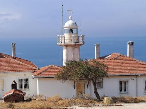
Anadolu Feneri
Anadolu Light, Anadolufeneri, May 2011
Flickr Creative Commons photo by Pi István Tóth

Dardanelles Asiatic Side Lighthouses

The Dardanelles is the strait connecting the Sea of Marmara to the Aegean Sea. Known in Turkish as the Çanakkale Boğazı (Çanakkale Strait), the strait is 61 kilometers (38 mi) long but only 1.2 to 6 kilometers (0.75 to 4 mi) wide. Lighthouses on the western side of the Dardanelles (also in Çanakkale Province) are described on the European Türkiye page and lighthouses of Çanakkale Province south of the Dardanelles are listed on the Western Türkiye page. A bridge across the strait, opened to traffic on 18 March 2022; has the world's longest suspension span.

Central Çanakkale Province (Dardanelles Asiatic Side) Lighthouses
[Kumkale Burnu (3?)]
2002 (station established 1856). Active; focal plane 12 m (39 ft); two white flashes every 10 s. 6 m (20 ft) hourglass-shaped tower, painted white with two narrow black horizontal bands. Trabas has a Capt. Peter's photo, Sea-seek.com has a photo, and Google has an indistinct satellite view. Located on an old fort on the south side of the entrance to the Dardanelles. Site status unknown. Admiralty N4848; NGA 16980.
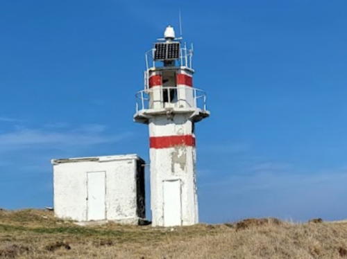
* Kepez (Kanlidere Burnu) (2)
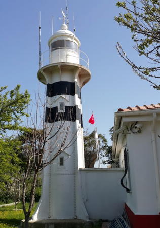
1936 (station established 1857). Active; focal plane 10 m (33 ft); white flash every 5 s. 10 m (33 ft) round cylindrical cast iron tower with lantern, gallery, and four ribs. Lighthouse painted white with two black horizontal bands. A photo uploaded in 2016 shows the horizontal bands painted black, Trabas has Capt. Peter's photo, seen at right, showing the bands painted orange, John Tuncayoz has a good closeup 2012 photo (1/3 the way down the page) showing the tower all white, and Google has a 2014 street view showing orange bands and also a satellite view. The first lighthouse was also a cast iron tower. Located on a prominent cape on the Asiatic side of the strait about 10 km (6 mi) southwest of Çanakkale, marking the beginning of the narrow portion of the strait. Site apparently open, tower closed. ARLHS TUR-033; Admiralty N4854; NGA 16988.
* Çimenlik (Çanakkale Kalesi) (4)
Date unknown (since 2002; station established 1858). Active; focal plane 15 m (49 ft); flash every 5 s, green or red depending on direction. 14 m (46 ft) round barbell-shaped metal or fiberglass tower, painted white with one green horizontal band. Trabas has Capt. Peter's photo and Google has a satellite view. The light is at the foot of Çimenlik Kalesi (castle), built by Sultan Mehmet the Conqueror in 1452. The first two lights were mounted on the castle and the third was a skeletal tower. Çanakkalle is on the southwest (Asian) side of the strait at the first major turn for northbound ships. Located on the bank of the strait on the south side of Çanakkale. Site apparently open, tower closed. ARLHS TUR-017; Admiralty N4857; NGA 16996.
Nağara (Nara) Burnu
Date unknown (station established 1857). Active; focal plane 10 m (33 ft); two green flashes every 10 s. 9 m (30 ft) round cylindrical white metal or fiberglass tower, painted white with two green horizontal bands. Trabas has Capt. Peter's photo and Google has a distant satellite view. Located at the tip of a spit, marking a very sharp bend in the strait about 5 km (3 mi) north of Çanakkale. Site probably open, tower closed. Admiralty N4862; NGA 17000.
* Bergaz (Gocuk Burnu, Umurbey)
Date unknown. Active; focal plane 12 m (39 ft); white flash every 3 s. 10 m (33 ft) round cylindrical white concrete tower. A radar tower about 21 m (62 ft) tall stands just behind the lighthouse. Trabas has a closeup, Enzar Töre has a 2021 photo, Gökhan Can has a photo, and Google has a good satellite view. Located on a prominent headland near Kemiklialan. Site open, tower closed. Admiralty N4870; NGA 17032.
Çardak Burnu (Çardak Plajı) (2?)
Date unknown (station established 1858). Active; focal plane 12 m (39 ft); green flash every 3 s. 11 m (36 ft) round metal tower, painted white with a narrow green horizontal band. Trabas has a photo and Google has a satellite view. Located on a long sand spit sheltering the harbor of Çardak. Site status unknown; there's a distant view of the light from ferries crossing the northern end of the strait between Çardak and Gelibolu (Gallipoli). Admiralty N4876; NGA 17044.

Kepez Light, Çanakkale, ca. 2014
photo copyright Capt. Peter Mosselberger; used by permission

Sea of Marmara Asiatic Side Lighthouses

The Sea of Marmara (Marmara Denizi in Turkish) occupies a basin opened by the North Anatolian Fault. Joined to the Black Sea by the Bosporus and to the Aegean Sea by the Dardenelles, the sea is about 280 km (175 mi) long east to west and 80 km (50 mi) wide.

Northern Çanakkale Province (Karabiga Area) Lighthouses
Karabiga Karaburun (İnce Burnu)
1964. Active; focal plane 54 m (177 ft); two white flashes every 5 s. 11 m (36 ft) round cylindrical concrete tower, painted white with three narrow black horizontal bands. Google has a distant satellite view. This is one of at least four İnce Burnu (Sharp Cape) lighthouses in Türkiye; the name Karaburun (Black Cape) is preferable although there also several Karaburun lighthouses in Turkey as well. Located on a rugged promontory on the south side of the eastern entrance to the Dardanelles from the Sea of Marmara. Site status unknown, probably difficult to reach. ARLHS TUR-028; Admiralty N4880.6; NGA 17112.
* Karabiga Kale Burnu (Karabiga)
Date unknown. Active; focal plane 23 m (75 ft); white flash every 5 s. 8 m (26 ft) square skeletal tower, painted white, adjacent to a square 1-story equipment building. Trabas has a photo, Ozay Osmanoglu has a distant street view, and Google has a satellite view. Located on the tip of Kale Burnu (Castle Point), a promontory sheltering the harbor of Karabiga. Accessible by road. Site open, tower closed. Admiralty N4881; NGA 17132.

Northern Balıkesir Province (Sea of Marmara South Coast) Lighthouses
Balıkesir Province also has a west coast on the Gulf of Edremit, an arm of the Aegean Sea. Lighthouses of the Edremit District are listed on the Western Türkiye page.

Ekinlik (Avşar) (2)
Date unknown (station established 1861). Active; focal plane 18 m (59 ft); white flash every 5 s. 10 m (33 ft) round barbell-shaped tower, painted white with a narrow black horizontal band. Kasım Oktay has a view from the sea, and Google has a satellite view. Located on Avşar, a small island about 2 km (1.25 mi) west of Avşa, the principal town of Turkeli Island. Accessible only by boat. Site status unknown. Admiralty N4882; NGA 17160.
Marmara Aba Burnu
Date unknown. Active; focal plane 40 m (131 ft); three white flashes every 15 s. 6 m (20 ft) round barbell-shaped tower painted white with a narrow black horizontal band. Google has a distant satellite view. Located on the southern tip of Marmara, the largest island in the sea of the same name. Site status unknown. Admiralty N4893; NGA 17156.
* Balyos (Palios) (3?)
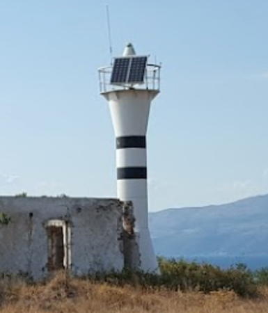
Date unknown (station established 1861). Active; focal plane 38 m (125 ft); two white flashes every 10 s. 12 m (39 ft) round hourglass-shaped tower, painted white with two narrow black horizontal bands. The tower stands next to a ruined 1-story masonry keeper's house. A KEGM photo is at right, Trabas has a closeup photo, Özgür Arda Bayram has a 2017 photo, İlhami Atiş has a 2016 photo, and Google has a satellite view of the ruined station. According to NGA, the previous light was on a skeletal tower. Located at the northwestern tip of the Erdek Peninsula just west of İlhanköy. Accessible by road. Site open, tower closed. Admiralty N4884; NGA 17164.

Balyos Light, İlhanköy
Coastal Safety Directorate photo
* Kapsüle Burnu
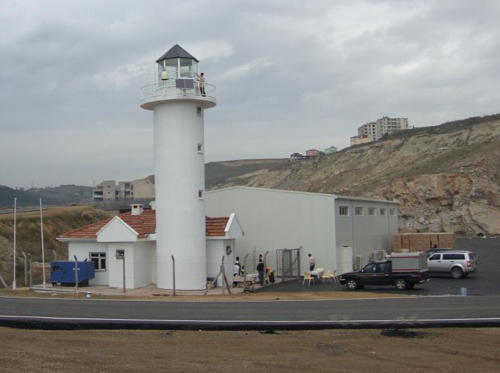
1945. Active; focal plane 20 m (66 ft); two red flashes every 10 s. 9.5 m (31 ft) round concrete tower with eight ribs and gallery, adjacent to a small 1-story concrete equipment room. 1-story keeper's house. Lighthouse painted white with two narrow red horizontal bands, house white with a red tile roof. Trabas has a closeup photo, İlhami Atiş has a 2016 photo, a very distant view is available, and Google has a distant satellite view. Located about 1.6 km (1 mi) north of Çakilköy, on the northeastern tip of the club-shaped Erdek Peninsula. Accessible by road. Site open, tower closed. Admiralty N4890; NGA 17172.
Fener Adası (2 and 3)
Date unknown (station established 1857). Active; focal plane 43 m (141 ft); white flash every 5 s. 11 m (36 ft) post rising from a 1-story keeper's house. The previous light, a square skeletal tower, also survives. Keepers' houses painted white with red roofs. Trabas has a photo and Google has a distant satellite view. "Fener Adası" means "lighthouse island." Located on a small island in the Mola Adalari (Mola archipelago) about about 2.5 km (1.5 mi) east southeast of Kapsüle Burnu and 11 km (6.5 mi) northeast of Bandirma on the south coast of the Sea of Marmara. Accessible only by boat. Site status unknown. Admiralty N4886; NGA 17188.

Bursa Province (Southeastern Sea of Marmara) Lighthouses
Değirmen Burnu (İmrali)
1959. Active; focal plane 25 m (82 ft); red flash every 3 s. 6 m (20 ft) concrete post attached to a small 1-story concrete equipment room. Entire lighthouse is white. No photo available but Google has a satellite view. Located on a headland about 1 km (1.6 mi) south of the northeastern tip of the island of İmrali, which is about 16 km (10 mi) due west of Boz Burnu. The site of a prison, the island is accessible by ferry from İstanbul and from Mudanya on the south shore of the Sea of Marmara. Site status unknown. Admiralty N4899.9; NGA 17196.

Kapsüle Burnu Light, Çakilköy, February 2023
Google Maps photo by Ersin Kutlu
* Tuzla Burnu (2)
Date unknown. Active; focal plane 14 m (46 ft); white flash every 10 s. 12 m (39 ft) round barbell-shaped white fiberglass tower mounted on a square concrete platform. Trabas has a photo, Serdar Üstünel has a 2017 photo, and Google has a satellite view. The original light was a square skeletal tower painted white. Located just off a sandy point on the south side of the approach to Gemlik, at the southeastern corner of the Sea of Marmara. Site open, tower closed. Admiralty N4900.6; NGA 17216.

Yalova Province (Eastern Sea of Marmara) Lighthouses
* Boz Burnu
1949. Active; focal plane 77 m (252 ft); white flash every 5 s. 9 m (30 ft) stone tower, painted white, with keeper's house. Fog siren (two blasts every 30 s). Merkez Emlak's 2019 photo is at right, Metin Dönmez has a closeup, and Google has a satellite view. Located in a rugged area at the tip of the Boz Peninsula, which projects into the southeastern corner of the Sea of Marmara. Site status unknown, but it appears that the lighthouse can be seen from nearby. Admiralty N4900; NGA 17225.
* Sivrikaya Burnu
Date unknown. Active; focal plane 20 m (66 ft); white flash every 10 s. 10 m (33 ft) round barbell-shaped white fiberglass tower. Trabas has a photo, Ali Sağlam has a distant view, and Google has an indistinct satellite view. Located on a promontory on the south side of the entrance to the easternmost basin of the Sea of Marmara. Accessible by road. Site open, tower closed. Admiralty N4899.96; NGA 17236.
* Çınarcık
Date unknown. Active; focal plane 9 m (30 ft); continuous green light. 7 m (23 ft) round white concrete tower. Trabas has a closeup photo, Tuncay Bektas has a photo, and Google has a distant satellite view. Located at the end of the breakwater at Çınarcık, about 15 km (9 mi) west of Yalova. Accessible by walking the pier. Site open, tower closed. Admiralty N4899.94; NGA 17238.
** Dil Burnu (2)
Date unknown (station established 1863). Inactive since 2013. The lighthouse, a 9 m (30 ft) square skeletal tower mounted atop a 1-story masonry keeper's house, was deactivated as construction began on the İzmit Bay (Osman Gazi) Bridge (completed in July 2016). No photo available but Google has a satellite view. Since restored, it is now a museum telling the story of its longtime keepers, the Gündoğdu family. Dil Burnu is a sharp-pointed cape projecting abruptly into the south side of the entrance to the Gulf of İzmit. a bay at the easternmost edge of the Sea of Marmara. Located at the tip of the cape, about 20 km (13 mi) east northeast of Yalova. Site open, museum hours unknown. Site manager: Altınova Municipality. ex-Admiralty N4924; ex-NGA 17254.

Boz Burnu Light, Boz Peninsula
Coastal Safety Directorate photo

Kocaeli Province West Coast (Northeastern Sea of Marmara) Lighthouses
Kocaeli Province also has a north coast on the Black Sea; see the Northern Anatolia page for that coast. These two lighthouses are on the Gulf of İzmit, a narrow eastward arm of the Sea of Marmara. The Osman Gazi Bridge crosses the western end of the gulf.

Kaba (Kava) Burnu (3)
2008 (station established 1896). Active; focal plane 14 m (46 ft); three white flashes every 10 s. 12 m (39 ft) round white concrete tower with lantern and gallery. A KEGM photo is at right, Sabri Keleş has a 2016 photo (taken on the day the Osman Gazi Bridge opened) and Google has a street view and a satellite view. This light was dropped by the Admiralty in 2014 and relisted briefly in 2017. It is charted as active by Navionics. Located on a promontory on the north side of the Gulf of Izmit, directly opposite Dil Burnu. Site status unknown. ex-Admiralty N4925.7 (2017) and ex-E4926 (until 2014); ex-NGA 17255.
Yelkenkaya Burnu (1)
1896. Reactivated (?); focal plane 20 m (66 ft); white flash every 15 s. 15 m (49 ft) round masonry tower with lantern and gallery, attached to the seaward end of a 1-story masonry keeper's house. Entire lighthouse painted white. Trabas has a photo and Google has a street view and a satellite view. Although a small skeletal tower is seen in front of the lighthouse, an Admiralty notice in December 2013 described the light as being in the historic tower. This lighthouse marks the north side of the entrance to the Gulf of İzmit. The house is clearly in use, but we do not know for what purpose. The lighthouse was strengthened after being damaged by an earthquake in 1998. Located on a prominent cape about 3 km (2 mi) west of Darica. Site status unknown, possibly open. ARLHS TUR-054; Admiralty N4922; NGA 17284.
 

Kaba Burnu Light, Gebze
Coastal Safety Directorate photo

Eastern İstanbul Province (İstanbul City and Bosporus Asiatic Side) Lighthouses

Southeast İstanbul Lighthouses
Tuzla Breakwater
Date unknown. Active; focal plane 12 m (39 ft); red flash every 5 s. 9 m (30 ft) round barbell-shaped metal tower painted white with a narrow red horizontal band. Trabas has a photo, Mike Ballard has a street view across the harbor, and Google has a distant satellite view. Tuzla is a town in the southeastern corner of İstanbul Province, known for shipbuilding and seafood restaurants. Located at the end of the breakwater of Tuzla harbor. Site status unknown. Admiralty N4920.5; NGA 17287.
Pendik South Breakwater
Date unknown. Active; focal plane 6 m (20 ft); green flash every 5 s. 10 m (33 ft) octagonal cylindrical concrete tower, painted white. Trabas has a photo and Google has a satellite view. Located on the south breakwater at Pendik, about 25 km (15 mi) southeast of İstanbul. Site status unknown, possibly open. Admiralty N4916.2; NGA 17296.
Dilek Kayalığı
Date unknown. Active; focal plane 9 m (30 ft); six quick white flashes and one long white flash every 15 s. 9 m (30 ft) round barbell-shaped tower on a stone pier. Upper half of the tower painted yellow and lower half black. Trabas has a photo but the light is barely visible in Bing's satellite view. Kayalığı is a rocky shoal. Located on a shoal halfway between the Feyzullah neighborhood of southeast İstanbul and the island of Kınalı. Accessible only by boat. Site open, tower closed. Admiralty N4915; NGA 17304.
* Fenerbahçe (Fenerbaçe, Fener Burnu, Seraglio Point)
1857. Active; focal plane 25 m (82 ft); two long (1.5 s) white flashes every 12 s. 20 m (66 ft) 2-stage round cylindrical stone tower with double gallery, painted white. Fog siren (blast every 60 s). Ömer Özmen has the 2019 photo at right, Trabas has a photo, Omer Ufacik has a 2019 evening photo of the lighthouse in action, Suat Gürler has a 2023 photo, Ahmet Tanju has a closeup, Huelse has a historic postcard view, and Google has a satellite view. Fener Bahçe means "Lighthouse Garden." Located on an island, separated from the mainland by only a narrow channel, near the end of the Fener Kalamis Caddesi about 1.5 km (1 mi) south of Kadıköy. Site open, tower closed. . ARLHS TUR-021; Admiralty N4910; NGA 17328.
* Kadıköy Breakwater (İnciburnu)
1977. Active; focal plane 14 m (46 ft); white light, 2 s on, 2 s off. 11 m (36 ft) round concrete tower with a round enclosure at the top, painted white with a narrow black horizontal band. Igor Checkanof has a 2021 photo, a closeup photo is available, Trabas also has a closeup, Köhler has a good photo, Urho Kekkonen has a more distant view, Ronan Jameson has a street view, and Google has a satellite view. The round enclosure was added between 2006 and 2008. Located at the end of a short breakwater on the south side of Kadıköy harbor, just southeast of the entrance to the Bosporus. Accessible by walking the pier. Site open, tower closed. Admiralty N4904.6; NGA 17360.

Fenerbahçe Light, İstanbul, September 2019
Google Maps photo by Ömer Özmen

Bosporus Asiatic Side Lighthouses
The Bosporus is the strait connecting the Black Sea to the Sea of Marmara, which in turn connects to the Mediterranean Sea. Known to Turks as İstanbul Boğazı or simply as Boğaz (The Strait), the Bosporus is the narrowest of all the major straits commonly used by international shipping. It narrows from about 3700 m (2.3 mi) at the Black Sea entrance to about 700 m (2300 ft) in the northern part of İstanbul. Three major bridges cross the Bosporus connecting Europe and Asia. There are many lights along the strait and only the larger towers on the eastern side are listed here. Lighthouses on the western side of the strait are listed on the European Türkiye page. Visitors report that the best views of the Bosporus lighthouses are from the water; it can be a challenge to find them on land.
Haydarpaşa Inner Breakwater Southeast
1963. Active; focal plane 15 m (49 ft); red flash every 2 s. 12 m (39 ft) round white concrete tower with a narrow red horizontal band, rising from a square 1-story stone base. Trabas has a photo, Can Balcı has a 2008 photo, and Google has a satellite view. Located at the southern end of the detached Haydarpaşa breakwater, which shelters the commercial harbor on the Asiatic side of the entrance to the Bosporus. Accessible only by boat. Site and tower closed. ARLHS TUR-024; Admiralty N4906.2; NGA 17348.
Haydarpaşa Outer Breakwater Northwest
1963 (?). Active; focal plane 15 m (49 ft); green flash every 2 s. 12 m (39 ft) round concrete tower, painted white with a narrow green horizontal band. Trabas has a photo and Google has a sea view and a satellite view. Located at the northern end of the Haydarpaşa breakwater. Accessible only by boat. Site and tower closed. Admiralty N4904; NGA 17352.
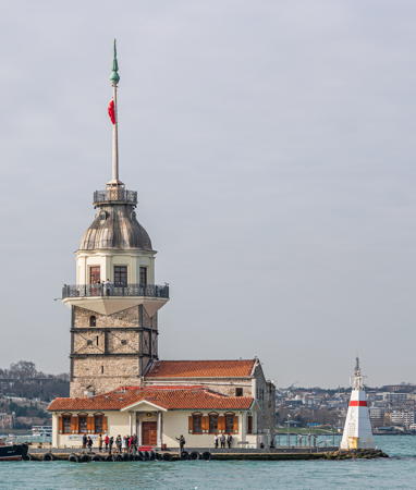
*** Kız Kulesi (Maiden's Tower, Leander's Tower) (1)
1763. Inactive. Approx. 23 m (75 ft) square cylindrical stone tower with a domed cupola, topped by a tall flagstaff. Adjacent to the historic building is an active light (next entry) mounted on a 9 m (30 ft) square pyramidal concrete tower painted white with a narrow red horizontal band. A photo is at right, Turkish Wikipedia has several photos, Krimou Skrimou has a 2018 closeup, an excellent 2019 photo is available, Emre Çagatay has a good 2008 nighttime photo, Huelse has a historic postcard view, and Google has a sea view and a satellite view. Kız Kulesi has a long and complicated history. The first structure known to have been built here was a fortress built by the Athenian general Alcibiades in 408 BCE. Another fortress was built by the Byzantine emperor Alexius Comnenus in 1110 CE. The first record of a lighthouse dates from 1509, in the early Ottoman period. The present form of the tower results from reconstructions by the Ottoman emperors Mustafa III in 1763 and Mahmud II in 1832. The tower is the subject of several romantic legends, leading to its name as the Maiden's Tower (Kız Kulesi in Turkish). The oldest legend is the classic Greek tale of Leander and Hero, who supposedly met at this spot. In 1995 the Ministry of Tourism leased Maiden's Tower for 49 years to the Hamoğlu Holding Company, which agreed to restore the structures and open them to tourists. The restoration was completed in 2000. Today the building houses a museum and a popular restaurant. The tower was featured in the James Bond movie The World Is Not Enough and for U.S. television viewers it appeared in season 7 of The Amazing Race. The exterior of the tower was restored in 2022. Located on an islet 200 m (220 yd) off the Asiatic shore at the southern entrance to the Bosporus. Accessible by passenger ferries from both sides of the strait. Site open, restaurant and tower open daily. Site manager: Hamoğlu Holding Co. (Kız Kulesi ). ARLHS TUR-038.

Kız Kulesi, İstanbul, February 2020
Wikimedia public domain photo by A. Savin
* Kız Kulesi (2)
Date unknown. Active; focal plane 11 m (36 ft); flash every 3 s, white or red depending on direction. 10 m (30 ft) square pyramidal metal tower painted white with one narrow red horizontal band. The tower is seen at lower right in the photo above, Trabas has a closeup, and Köhler also has a photo. Located next to the historic Kız Kulesi. Site open, tower closed. Admiralty N4903.8; NGA 17372.
* Çengelköy
Date unknown. Active; focal plane 15 m (49 ft); three red flashes every 15 s. 13 m (43 ft) round hourglass-shaped fiberglass tower. Lighthouse painted white with three narrow red horizontal bands. Trabas has a photo, Kemal Bulungiray has a drone view, and Google has an indistinct satellite view. For northbound ships the light marks the first sharp turn in the Bosporus, just north of the Boğaziçi (Bosporus) Bridge. Located on the waterfront on the east bank of the Bosporus in the Çengelköy neighborhood. Site open, tower closed. Admiralty N4938.3; NGA 17400.
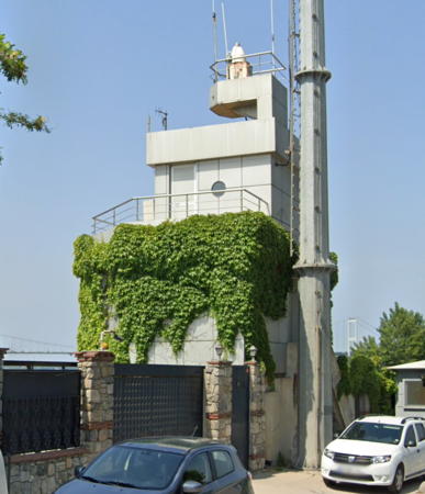
* Kandilli Burnu
Date unknown. Active; focal plane 27 m (89 ft); red flash every 3 s. Light mounted on a tower attached to the 2-story Bosporus Navigation Control building. Capt. Peter's photo is at right, Trabas has another photo by Capt. Peter, and Google has a street view and a satellite view. Located on a promontory at a sharp bend in the Bosporus in the Kandilli neighborhood, on the east bank of the Bosporus. Site open, tower closed. Admiralty N4944; NGA 17412.
Kanlıca Burnu
Date unknown. Active; focal plane 12 m (39 ft) (?); two red flashes every 10 s. 11 m (36 ft) square skeletal tower, painted white. Trabas has Capt. Peter's photo and it peeks over trees in Google's street view, but the tower is hard to see in Google's satellite view. The focal plane is more like 22 m (72 ft) rather than 12 m. Located on a prominent headland about 1.6 km (1 mi) north of the Fatih Sultan Mehmet Bridge. Site status unknown. Admiralty N4948; NGA 17428.
Paşabahçe
1973. Active; focal plane 14 m (46 ft); three red flashes every 15 s. 12 m (39 ft) round hourglass-shaped tower, painted white with three narrow red horizontal bands. Located on a short pier at Paşabahçe, on the Asiatic side of the Bosporus about halfway between the Black Sea and downtown İstanbul. Trabas has a closeup photo and Google has a sea view and a satellite view. Site status unknown (the light is in an industrial area that may be closed to the public). Admiralty N4949.4; NGA 17432.
Selvi Burnu
Date unknown. Active; focal plane 13 m (43 ft); two red flashes every 10 s. 12 m (39 ft) round hourglass-shaped metal tower, painted white with two narrow red horizontal bands. Trabas has a photo and Google has a satellite view. Located on a prominent cape at Yalıköy, about 4 km (2.5 mi) northwest of Paşabahçe. Site status unknown. Admiralty N4949.7; NGA 17456.
Kandilli Burnu Light
Kandilli Burnu Light, İstanbul
photo copyright Capt. Peter Mosselberger; used by permission
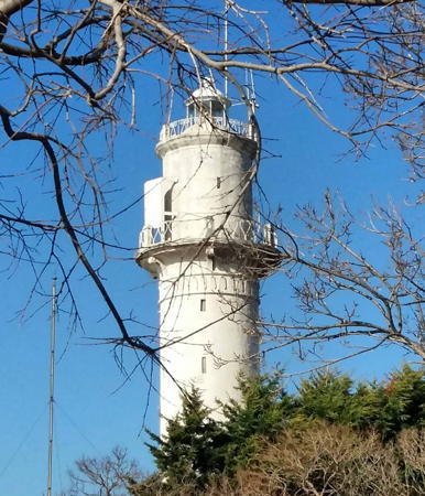
*** Anadolu (2)
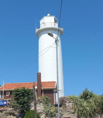
1856 (station established 1830). Active; focal plane 75 m (246 ft); one long (2 s) white flash every 20 s. 19 m (62 ft) round stone tower with lantern and gallery, painted white. 2-story masonry keeper's house; attached to the house is a slender round tower with gallery resembling a minaret. Pi István Tóth's photo is at the top of this page, Trabas has a Capt. Peter's closeup photo, another closeup is available, Özözlü has a distant photo, and Google has a street view, a sea view, and a satellite view. Anadolu is the Turkish name for Anatolia, and the lighthouse stands on the east (Anatolian) side of the entrance to the Bosporus from the Black Sea. Located on a high promontory above the village of Anadolufeneri. Site open, tower listed by the Coastal Safety Directorate as open to visitors. ARLHS TUR-014; Admiralty N4958; NGA 17508.
[Yom Burnu (fog signal)]
Date unknown. Active; two siren blasts every 32 s. Approx. 24 m (79 ft) round white concrete tower with gallery carrying several radar antennas. Trabas has a photo and Google has a sea view and a satellite view. Located atop a headland about 2 km (1.25 mi) northeast of the Anadolu lighthouse. Site status unknown. Admiralty N4960; NGA 17512.

Information available on lost lighthouses:

Notable faux lighthouses:

Adjoining pages: East: Northern Anatolia | South: Western Türkiye | West: European Türkiye

Return to the Lighthouse Directory index | Ratings key

Posted April 16, 2007. Checked and revised June 23, 2023. Lighthouses: 36. Site copyright 2023 Russ Rowlett and the University of North Carolina at Chapel Hill.