Lighthouses of Western Venezuela

Located on the north coast of South America, the Bolivarian Republic of Venezuela has a long coastline facing the Caribbean Sea. This page includes lighthouses of the western half of that coast, west of the La Guaira-Caracas area. The Eastern Venezuela page includes lighthouses on the remainder of the coast. In addition Venezuela administers a number of islands in a westward extension of the Lesser Antilles chain. The lighthouses of the Isla Margarita and Venezuela's other Caribbean islands are listed on the Venezuela: Caribbean Islands page.

Venezuela is a federal republic of 23 states, a capital district, and a federal territory administering the more remote Caribbean islands.

The word for a lighthouse is faro in Spanish; smaller lighthouses are often called balizas (beacons). In Spanish isla is an island, cabo is a cape, punta is a promontory or point of land, péñon is a rock, arrecife is a reef, bahía is a bay, ría is an estuary or inlet, estrecho is a strait, río is a river, and puerto is a port or harbor.

Active lighthouses in Venezuela are owned by the navy and managed by the Direccion de Hidrografia y Navegacion (DHN) within the Oficina Coordinadora de Hidrografía y Navegación (OCHINA), an agency of the Defense Ministry.

Special note: Following the election of President Nicolás Maduro in 2013 economic conditions in Venezuela deteriorated, leading to an outbreak of civil unrest. As of this revision (May 2024) the country is still not safe for tourists and other visitors.

ARLHS numbers are from the ARLHS World List of Lights. Admiralty numbers are from volume J of the Admiralty List of Lights & Fog Signals. U.S. NGA numbers are from Publication 110.

General Sources
Online List of Lights - Venezuela
Photos by various photographers posted by Alexander Trabas. The Venezuelan photos are mostly by Capt. Peter Mosselberger ("Capt. Peter") or Capt. Theo Hinrichs ("Capt. Theo").
Lighthouses in Venezuela
Photos by various photographers available from Wikimedia.
World of Lighthouses - Venezuela
Photos by various photographers available from Lightphotos.net.
Señales Marítimas Venezolanas
Posted by DHN, a map locates the Venezuelan lighthouses with their names and geographic coordinates.
Lighthouses of Venezuela
Historic postcard images posted by Michel Forand.
Leuchttürme Südamerikas auf historischen Postkarten
Historic postcard images posted by Klaus Huelse.
GPSNauticalCharts
Navigation chart for Venezuela.
Navionics Charts
Navigation chart for Venezuela.


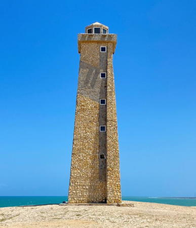
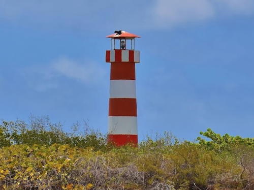
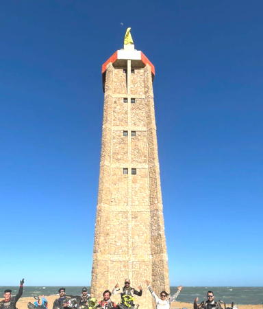
Cabo San Roman Light, Paraguaná, March 2023
Instagram photo by Daniel Ronson Winehouse
Zulia Lighthouses
Zulia is the state surrounding Lake Maracaibo, a brackish gulf connected by a narrow strait to the Gulf of Venezuela. A dredged channel has replaced the natural strait as the entrance to the lake for modern ships. To reach the port of Maracaibo, ships must cross a northern basin of the lake known as the Bahía de Tablazo.

Punta Perret (4)
2010 (station established 1980). Active; focal plane 26 m (85 ft); white flash every 15 s. 24 m (79 ft) square concrete tower with lantern and gallery. A closeup 2021 photo is available, Fernic Tona has a 2020 photo, Angel Gonzalez has a 2016 photo and Google has a satellite view. A small skeletal tower was replaced by a fiberglass tower in 1993 and then in 2003 by a tall skeletal tower. Located on a cape on the west side of the Gulf of Venezuela about 7 km (4 mi) south of the Colombian border. Site status unknown. ARLHS VEN-021; Admiralty J6269; NGA 16856.
Isla San Carlos (Lago de Maracaibo) (2)
2013 (station established 2005). Active; focal plane 24 m (79 ft); white flash every 10 s. 15 m (49 ft) square skeletal tower on a round concrete base. Lighthouse painted with red and white horizontal bands. Capt. Theo's photo is at right, Vladimir Gonzalez has a closeup photo, Trabas has Capt. Peter's photo, and Google has a satellite view. The 2005 lighthouse was a round fiberglass tower; Ricardo Mendoza has a 2008 photo. Like Monjes del Sur, this is one of a number of critical locations equipped with new light towers by the Venezuelan Navy. The lighthouse is actually located on the Isla de San Bernardo, which is tenuously connected to the mainland via the Isla San Carlos, marking the west side of the dredged entrance to the Lago de Maracaibo from the Gulf of Venezuela. Site status unknown. ARLHS VEN-001; Admiralty J6275; NGA 16860.2.
Canal Interior Malecon del Este (East Breakwater) (1?)
Date unknown. Inactive but listed with focal plane 14 m (46 ft); white flash every 5 s. 7 m (23 ft) round rubblestone tower. Trabas has Capt. Peter's photo and Google has an indistinct satellite view. The photo also shows a round conical tower, but no light is visible on either tower. The Admiralty deleted the light in 2018. Located on the breakwater on the east side of the dredged entrance to the Lago de Maracaibo from the Gulf of Venezuela. Site status unknown. ex-Admiralty J6274; NGA 16860.
#Maracaibo Channel Range Rear
Date unknown. Inactive but listed with focal plane 42 m (138 ft); green flash every 4 s. 39 m (128 ft) square pyramidal skeletal tower, mounted on a square platform supported by piles. Trabas has Capt. Peter's photo showing the tower collapsed and Google has a satellite view. This is or was an outbound (northbound) range for vessels leaving Maracaibo. The former front light has vanished. In 2018 the Admiralty deleted its listing of the front light and labeled the rear light as "temporarily extinguished." Located in the upper Lago de Maracaibo about 8 km (5 mi) east of Las Delicias. Accessible only by boat. Site open, tower closed. Admiralty J6283.1; NGA 16873.1.
Maracaibo Inner Channel Range Front
Date unknown. Inactive but listed with focal plane 27 m (89 ft); green flash every 1.5 s. 27 m (89 ft) square pyramidal skeletal tower, mounted on a square platform supported by piles. Trabas has Capt. Peter's photo of the abandoned tower and Google has a satellite view. This was an inbound (southbound) range for vessels entering Maracaibo. In 2018 the Admiralty labeled both front and rear lights as "temporarily extinguished." Located 1.65 km (1 mi) north of the transmission line. Accessible only by boat. Site open, tower closed. Admiralty J6279.9; NGA 16872.

Isla San Carlos Light
Isla San Carlos Light, Lago de Maracaibo, December 2013
photo copyright Capt. Theo Hinrichs; used by permission

#Maracaibo Inner Channel Range Rear
Date unknown. Inactive but listed with focal plane 39 m (129 ft); green flash every 1.5 s. This was a 27 m (89 ft) square pyramidal skeletal tower, mounted on a square platform supported by piles. The tower appeared abandoned in an earlier photo by Capt. Peter and the tower is gone in his more recent photo. Google has a satellite view. At one time the rear light was on one of the electric transmission line towers crossing the lake just north of the city of Maracaibo. Located just to the south of electric transmission line towers crossing the lake just north of the city of Maracaibo. Accessible only by boat. Site open, tower closed. Admiralty J6280; NGA 16872.1.
Bahía de Maracaibo Quay (Sur) (2?)
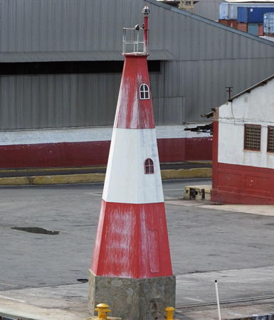
Date unknown (station established 1938). Active; focal plane 15 m (49 ft); white flash every 4 s. 10 m (33 ft) hexagonal tower, painted red with a white horizontal band. Trabas has Capt. Theo's photo (also seen at right) and Google has a satellite view. Located on a quay in Maracaibo. Site status unknown. Admiralty J6287; NGA 16873.83.
Moporo
Date unknown. Active; focal plane 15 m (49 ft); white flash every 10 s. 12 m (39 ft) orange and white fiberglass tower. No photo available but Google has an indistinct satellite view. Located at Moporo, a town on the east coast of Lake Maracaibo. Site status unknown. Admiralty J6294; NGA 16875.5.

Falcón Lighthouses
The large state of Falcón includes the east side of the Gulf of Venezuela and the bulbous Paraguaná Peninsula, the northernmost extension of the Venezuelan mainland. The peninsula is almost an island, being connected tenuously to the mainland by the narrow Isthmus of Médanos.

Punta Borojó (2)
Date unknown. Active; focal plane 15 m (49 ft); one long (1.2 s) white flash every 12 s. 15 m (49 ft) square skeletal tower painted with red and white horizontal bands. This light replaced a round cylindrical fiberglass tower, also painted with red and white horizontal bands. Gerardo Rondon has a closeup 2021 photo, Ronald Gonzalez has a 2022 photo, and Google has a satellite view. Located on a sandy point of land on the south side of the Gulf of Venezuela. Site status unknown. Admiralty J6297; NGA 16875.


Bahía de Maracaibo Quay Light, Maracaibo
photo copyright Capt. Theo Hinrichs; used by permission

* Guaranao
Date unknown. Active; focal plane 36 m (118 ft); two long (1.5 s) flashes every 12 s, red or green depending on direction. 10 m (33 ft) hexagonal fiberglass tower, orange with one white horizontal band. Trabas has Capt. Peter's photo, Daniel Lopez Martinez has a 2011 photo, Ana Vergara has a distant 2022 street view, and Google has a satellite view. The green sector guides vessels entering the Guaranao harbor on the south side of Punto Fijo, a city of about 275,000 residents at the southwestern corner of the Paraguaná Peninsula. Located on a bluff overlooking the south side of the harbor and city. Site appears open, tower closed. Admiralty J6299; NGA 16879.7.
Punta Fijo
Date unknown. Active; focal plane 40 m (131 ft); one long green flash every 10 s. 10 m (33 ft) hexagonal fiberglass tower, colored orange with one white horizontal band. Trabas has Capt. Peter's distant view from the sea and Google has a satellite view. Located in the Venezuelan Navy's Base Naval Falcón in Punto Fijo. Site and tower closed. Admiralty J6300.4; NGA 16890.
Bahía de Amuay Range Front
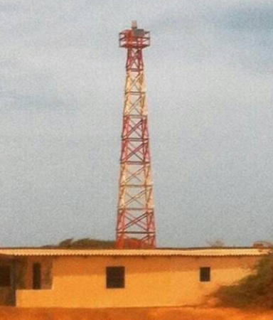
Date unknown. Active; focal plane 37 m (122 ft); green flash every 5 s. Approx. 33 m (108 ft) skeletal mast painted with red and white horizontal bands. Trabas has Capt. Peter's photo of the two range lights and Google has a satellite view. Located in the Paraguaná Refinery Complex, described as "the world's third largest refinery complex" in Amuay, a traditional fishing town on the west coast of the Paraguaná Peninsula. Site and tower closed. Admiralty J6310; NGA 16880.
Bahía de Amuay Range Rear
Date unknown. Active; focal plane 48 m (156 ft); green flash every 5 s. Approx. 42 m (138 ft) skeletal mast painted with red and white horizontal bands. Trabas has Capt. Peter's photo of the two range lights and Google has a satellite view. Located 365 m (400 yd) east northeast of the front light. Site and tower closed. Admiralty J6310.1; NGA 16884.
* Punta Macolla (Macoya) (2)
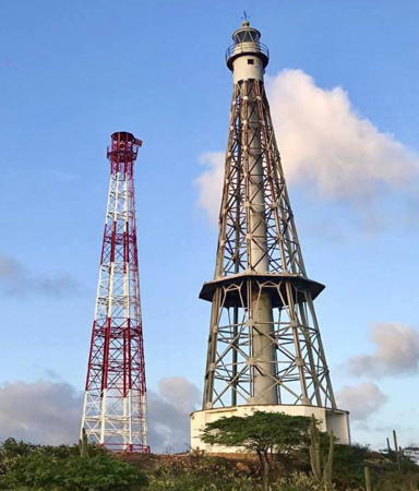
1988 (station established 1927). Inactive since 2021-22. 41 m (135 ft) octagonal cast iron skeletal tower with central cylinder, lantern, and gallery mounted on a concrete base. An octagonal 1-story keeper's quarters with wood siding was formerly incorporated in the tower. Carlos Santana has a 2021 photo, Andres Figueira has a fine 2005 closeup, Trabas has Capt. Peter's photo, Wikimedia has Elias Rodriguez Azcarate's 2009 view, and Google has a good satellite view. The original lighthouse was badly deteriorated by the 1980s, so a copy of it was built in 1988 to replace it. The tower formerly carried a keeper's house, seen in the earlier photos; it was removed sometime in the mid 2010s. It is said that the Dutch island of Aruba can be seen from the base of the lighthouse. Located on the north coast of the Paraguaná Peninsula. Accessible by hiking trail. Site open, tower closed. .
* Punta Macolla (Macoya) (3)
2021-22 (station established 1927). Active; focal plane 48 m (157 ft); white flash every 10 s. 41 m (135 ft) octagonal skeletal tower with lantern and gallery painted with red and white horizontal bands. A 2022 photo is at right, Yanko Guillen has a July 2022 photo of both towers, and Google has a good satellite view. Located on the north coast of the Paraguaná Peninsula. Accessible by hiking trail. Site open, tower closed. . ARLHS VEN-018; Admiralty J6312; NGA 16896.

Punta Macolla Light, Paraguaná, July 2022
Instagram photo by ingeconsult1975

* Cabo San Roman (5?)
Around 2004 (station established 1928). Active; focal plane 34 m (112 ft); white flash every 6 s. 24 m (79 ft) square stone tower with lantern and gallery; the walls of the lighthouse are extended so that the tower has a trapezoidal profile. Daniel Ronson Winehouse's 2023 photo is at the top of this page, OCHINA has a good photo, Javier Heredia has a fine 2015 photo, Rahuld Barraez D'Lucca has a closeup, José Jaime Araujo also has a photo, Trabas has Capt. Peter's photo, and Google has a closeup street view and a good satellite view. The original 9 m (30 ft) tower was replaced during World War II by a short skeletal tower; higher skeletal towers were built in 1975 and in 1997. In clear weather the new lighthouse is distantly visible from Aruba. Located on the beach at the northernmost point of the Paraguaná Peninsula. Site open, tower closed. . ARLHS VEN-024; Admiralty J6314; NGA 16900.
* Punta Adícora (2?)
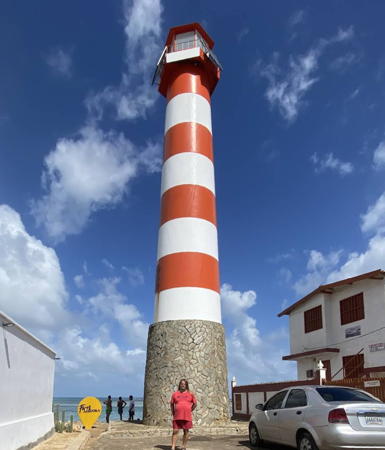
Date unknown (station established 1931). Active; focal plane 17 m (56 ft); white flash every 16 s. 17 m (56 ft) round fiberglass tower with hexagonal lantern and gallery, mounted on a round stone base. Tower painted with red and white horizontal bands; gallery painted with red and white horizontal bands. Ralf Kierstein's 2023 photo is at right, Jorge Armando Navas has a 2021 closeup, José Cherubini has a photo, Ángel Ravelo Rodríguez has a nice photo, another excellent closeup is available, Wikimedia has a closeup, and Google has a satellite view. The original light was on a 12 m (39 ft) skeletal tower. Located on a point of land in the beach resort town of Adícora, on the east side of the Paraguaná Peninsula. Site open, tower closed. . Admiralty J6428; NGA 16904.
Punta Taima-Taima (3?)
Date unknown. (station established 1931). Active; focal plane 59 m (194 ft); white flash every 7 s. Approx. 15 m (49 ft) square skeletal tower painted with red and white horizontal bands. This light replaced a hexagonal metal tower, colored orange with one white horizontal band. Filippo Bilotti has a 2022 view from higher on the slope and Google has a satellite view. Located on a rugged cape about 15 km (9 mi) northeast of La Vela de Coro. Site status unknown. Admiralty J6434; NGA 16912.
Punta Tomoro (Punta Manzanillo)
Date unknown. Active; focal plane 45 m (148 ft); white flash every 6 s. Approx. 12 m (39 ft) hexagonal fiberglass tower, colored orange with one white horizontal band. No photo available and the lighthouse is not conspicuous in Bing's satellite view. Located on a prominent cape about 15 km (9 mi) northeast of Puerto Cumarebo. Site status unknown. Admiralty J6438; NGA 16920.

Punta Adícora Light, Adícora, January 2023
Google Maps photo by Ralf Kierstein
Punta Zamuro
Date unknown. Active; focal plane 16 m (52 ft); white flash every 10 s. 12 m (39 ft) round cylindrical fiberglass tower colored with orange and white horizontal bands. No photo available but Google has a satellite view. Located on Punta Zamuro near the village of San José de la Costa. Site status unknown. Admiralty J6440; NGA 16924.
Punta Aguide
Date unknown. Active; focal plane 50 m (164 ft) (?); one long white flash every 15 s. 12 m (39 ft) round cylindrical fiberglass tower colored with orange and white horizontal bands. No photo available but Google has a distant satellite view. Located on a promontory near the village of Aguide. Site status unknown. Admiralty J6441; NGA 16928.
Cayo Noroeste (3?)
Date unknown. Active; focal plane 15 m (49 ft); white flash every 6 s. 12 m (39 ft) round fiberglass tower, painted with orange and white horizontal bands. No photo available but Google has an indistinct satellite view. The lighthouse replaced a square skeletal tower. Located on a small cay about 6 km (3.5 mi) northeast of Los Boquerones. Accessible only by boat. Site status unknown. Admiralty J6442; NGA 16932.
Cayo Borracho (3)
Date unknown (station established 1930). Active; focal plane 16 m (52 ft); white flash every 8 s. 14 m (46 ft) round fiberglass tower with octagonal lantern and gallery. Tower painted with red and white horizontal bands; gallery painted with vertical red and white stripes. This lighthouse is a twin of the Isla Chimana Segunda light pictured below. Joao Abel Goncalves has the 2014 photo at right, Reinaldo Gimón has a more distant view, Trabas has Capt. Theo's distant view from the sea, and Google has a satellite view. The original light was replaced in 1937. Located on a small cay about 15 km (9 mi) north of Chichiriiviche. Accessible only by boat. Site and tower closed. Admiralty J6444; NGA 16936.

Cayo Borracho Light, Puerto Cabello, July 2014
Google Maps photo by Joao Abel Goncalves

Carabobo (Puerto Cabello Area) Lighthouses
Carabobo is a relatively small state facing north on the Golfo Triste, an open bight of the Caribbean Sea. Puerto Cabello, a city of about 200,000 residents, is Venezuela's largest and busiest port; it includes a shipyard and a naval base.
Isla Guaiguaza (Goaiguaza)
Date unknown. Active; focal plane 13 m (43 ft); white flash every 8 s. 12 m (39 ft) hexagonal pyramidal tower, painted with orange and white horizontal bands. Kliber Pereira has a 2022 photo, Trabas has Capt. Peter's photo, and Google has a satellite view. Located on a small cay about 3 km (2 mi) west of the entrance to Puerto Cabello. Accessible only by boat. Site status unknown. Admiralty J6448.4; NGA 16956.
* [Fortín Solano]
Date unknown. Active; focal plane 168 m (551 ft); three white flashes every 15.5 s. Listed as a 6 m (20 ft) skeletal tower, painted white. In June 2012 Capt. Peter Mosselberger visited the fort and found the light to be at the top of the lower of two slatted daymark panels, each painted red with a white horizontal band and mounted on posts below the wall of the fort. Trabas has his photo and Pedro Ocariz has a beautiful street view that shows both the light and the view, but the light is not seen in Google's satellite view of the fortress. The Fortín Solano, built starting in 1766, is one of the best-preserved colonial-era fortifications in Venezuela. Antonio Rojas has a photo of the fortress. Located on a high ridge overlooking Puerto Cabello. Site and fortress open. Admiralty J6447; NGA 16976.
Puerto Cabello Pier M-7
2006-07. Active; focal plane 16 m (52 ft); red flash every 6 s. 14 m (46 ft) hexagonal pyramidal fiberglass tower, mounted on a masonry base. Lighthouse painted red with one white horizontal band. Trabas has Capt. Peter's photo (a slightly different view is seen at right) and Google has a satellite view. Located at a corner of the commercial quays directly opposite the Naval Quay light. Site status unknown. Admiralty J6449.5; NGA 16961.3.
Puerto Cabello Pier M-32
2006-07. Active; focal plane 16 m (52 , ft); red flash every 9 s. 12 m (39 ft) hexagonal pyramidal fiberglass tower, mounted on a masonry base. Lighthouse painted red with one white horizontal band. Trabas has Capt. Peter's photo, Nikolay Frolov has a distant street view along the quay, and Google has a satellite view. Located at a corner of the commercial quays about 1 km (0.6 mi) southeast of the Pier M-7 light (previous entry). Site status unknown. Admiralty J6449.7; NGA 16961.7.
Puerto Cabello Inner Port Range Front
Date unknown. Active; focal plane about 18 m (59 ft); white flash every 3 s. Approx. 15 m (49 ft) square skeletal tower, painted with red and white horizontal bands and carrying a triangular slatted daymark painted with red and white vertical stripes. Trabas has Capt. Peter's photo and Google has a satellite view. Located on the shoreline at the extreme southeastern end of Puerto Cabello's harbor. Site status unknown. Admiralty J6451.
Puerto Cabello Pier M-7 Light
Pier M-7 Light, Puerto Cabello
photo copyright Capt. Peter Mosselberger; used by permission
Puerto Cabello Inner Port Range Rear
Date unknown. Active; focal plane about 23 m (75 ft); white flash every 3 s. Approx. 15 m (49 ft) square skeletal tower, painted with red and white horizontal bands and carrying a triangular slatted daymark painted with red and white vertical stripes. Trabas has Capt. Peter's photo and Google has a satellite view. Located on the shoreline at the extreme southeastern end of Puerto Cabello's harbor. Site status unknown. Admiralty J6451.1.
Puerto Cabello Naval Quay (1) (?)
2006-07. Active; focal plane 16 m (52 ft); green flash every 6 s. 14 m (46 ft) hexagonal pyramidal fiberglass tower, mounted on a masonry base. Lighthouse painted green with one white horizontal band. Trabas has Capt. Peter's photo, a view from the bay is available, and Google has a satellite view. This light was reportedly replaced with a smaller tower in 2011 but it seems to be present in more recent satellite photos. Located at the southwest end of the main navy pier at Puerto Cabello. Site and tower closed. Admiralty J6449; NGA 16961.
Muelle La Planchita (3?)
Date unknown. Active; focal plane 13 m (43 ft); green flash every 4 s. 11 m (36 ft) hexagonal pyramidal fiberglass tower, mounted on a masonry base. Lighthouse painted green with one white horizontal band. Trabas has Capt. Peter's photo, Carlos E. Pérez has a photo, and Google has a satellite view. Forand has a postcard view of an earlier tower on this quay, a tall skeletal tower. Located at the southwest end of the main navy pier at Puerto Cabello. Site and tower closed. Admiralty J6448.7; NGA 16959.
Punta Brava (3)
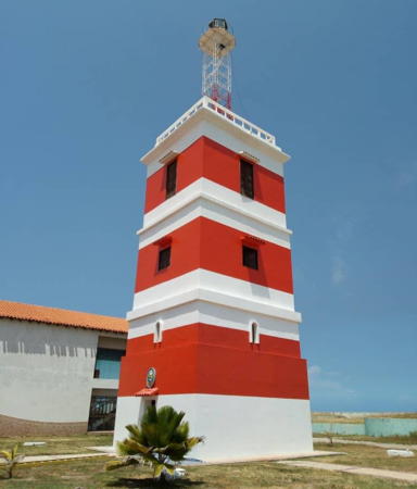
1901 (station established 1864). Active; focal plane 37 m (121 ft) (?); white flash every 10 s. Approx. 24 m (79 ft) square 4-story concrete tower topped by a square skeletal tower with lantern and gallery. Lighthouse painted with horizontal red and white bands. Bellasmin Caraballo has the 2021 photo seen at right, Trabas has Capt. Peter's photo, a 2002 postage stamp shows the lighthouse, Michel Forand has a 1910 postcard view, and Google has an excellent satellite view. Huelse also has a historic postcard view. This is Venezuela's oldest light station. The lighthouse was destroyed by a disastrous fire in October 1892; it was replaced by a light on a mast until the new lighthouse was built. The skeletal tower atop the building has been replaced several times, and its varying heights have changed the focal plane. In fact a 2012 photo by Luis Pages shows a shorter skeletal tower. For a time the focal plane was listed as 50 m (164 ft). NGA lists the current tower height as 37 m (121 ft), which still seems too high. In 2005 the Navy established its hydrographic research station in a modern building at the base of the lighthouse. Located on a headland just north of Puerto Cabello, the major port of northwestern Venezuela. Site and tower closed (naval installation). Site manager: Estación Hidrográfica de Puerto Cabello. ARLHS VEN-027; Admiralty J6448; NGA 16964.
Isla Alcatráz (Isla Santo Domingo) (2)
2011 (?). Active; focal plane 19 m (62 ft); white flash every 10 s. 15 m (49 ft) tower, listed as an orange fiberglass tower with a white band. However, Trabas has Capt. Peter's photo showing a square skeletal tower painted with red and white horizontal bands. Google has a satellite view. Located on the northwest corner of an island about 4 km (2.5 mi) northeast of Puerto Cabello. Accessible only by boat. Site status unknown. Admiralty J6452; NGA 16960.

Aragua Lighthouses
The state of Aragua is mostly inland; its short Caribbean coast includes steep headlands of the coastal mountain range (Cordillera de la Costa).

Bahía de Turiamo
Date unknown. Active; focal plane 15 m (49 ft); green light, 3 s on, 4 s off. 13 m (43 ft) hexagonal skeletal tower, painted green with a white horizontal band. Edgar Augusto Porras Sierra has a 2021 photo and Google has a distant satellite view. The Bahía de Turiamo is a well-protected natural harbor about 20 km (13 mi) east of Puerto Cabello. Located at the north end of the quay at a Venezuelan Navy station on the east side of the bay. Site and tower closed. Admiralty J6453; NGA 16992.

Punta Brava Light, Puerto Cabello, October 2021
Google Maps photo by Bellasmin Caraballo
Punta El Palito (Morro Choroní)
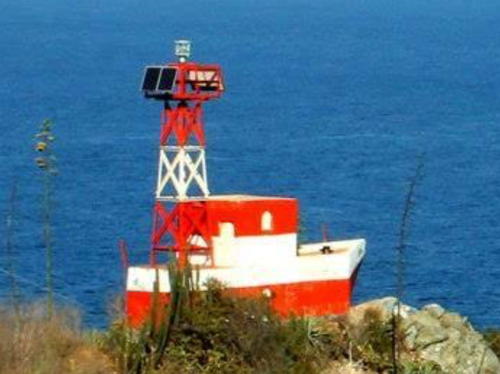
Date unknown. Active; focal plane 106 m (348 ft); white flash every 5 s. 6 m (20 ft) square tower on a structure resembling a small boat. Building painted orange with one white horizontal band. Mafy Garcia has a photo, Jesús Ortiz Buhrkohl has a closeup photo, Deibys Porras has a 2020 view, and Google has an indistinct satellite view. Located atop a very steep headland about 90 km (55 mi) west of La Guaira. Accessible by a hiking trail. Site open, tower closed. Admiralty J6453.4; NGA 16996.

Information available on lost lighthouses:

Notable faux lighthouses:

Adjoining pages: North: Venezuelan Caribbean | East: Eastern Venezuela | Southeast: Guyana | West: Colombia

Return to the Lighthouse Directory index

Posted July 7, 2003. Checked and revised May 19, 2024. Lighthouses: 34. Site copyright 2024 Russ Rowlett and the University of North Carolina at Chapel Hill.