Lighthouses of South Africa: KwaZulu-Natal

The Republic of South Africa occupies the southern end of the African continent, including the famous capes of Good Hope and Agulhas. During the colonial era Dutch and British colonists struggled for many years to control the country, but by the mid 1800s the entire coastline was under British control. As a result South Africa's lighthouse heritage is British.

The country was formed in 1910 as the Union of South Africa, an autonomous British dominion combining the Cape, Transvaal and Natal colonies and the former Orange Free State republic. Full independence was granted in 1931 and the Union became the Republic in 1961.

South Africa is divided into nine provinces and the provinces are divided into districts and municipalities. This page describes lighthouses in the province of KwaZulu-Natal. KwaZulu, "Place of the Zulu," refers to the historic Zulu Kingdom that ruled most of this area, and Natal was a British colony from 1843 to the formation of the Union in 1901. The province was established in 1994 following the end of the apartheid era in South Africa.

Located on the east side of the country, KwaZulu-Natal faces southeast on the Indian Ocean; its principal ports are Richards Bay and Durban. There are also pages for the province of Eastern Cape and the provinces of Western Cape and Northern Cape.

Lighthouses in South Africa are operated by the Lighthouses and Navigational Systems division of the Transnet National Ports Authority (TNPA). Some are still staffed. Some of the larger and more accessible light stations have been developed for tourism by the Transnet business office.

Official languages in South Africa include English, Afrikaans, and nine native African languages. In Afrikaans the word for a lighthouse is vuurtoring; eiland is an island, kaap is a cape, punt is a point of land, baai is a bay, and klip is a rock. In the Zulu language common in KwaZulu Natal indlu yesibani ("house of the lamp") is a lighthouse.

ARLHS numbers are from the ARLHS World List of Lights. Admiralty numbers are from volume D of the Admiralty List of Lights & Fog Signals. U.S. NGA List numbers are from Publication 112.

General Sources
Lighthouses of South Africa
A blog by Joe Viljoen; this valuable site has photos and information on nearly all South African lights.
Charmaine Blackburn - Lighthouses
Photos posted on Flickr.com by Ms. Blackburn. Her blog has additional photos.
Online List of Lights - South Africa
Photos by various photographers posted by Alexander Trabas. Many of the photos for this area are by Don Brotherston, a Johannesburg photographer.
Leuchttürme in Südafrika
Photos posted by Bernd Claußen.
Lighthouses in South Africa
Photos by various photographers available from Wikimedia.
World of Lighthouses - South Africa
Photos by various photographers available from Lightphotos.net.
Afrikanische Leuchttürme auf historischen Postkarten
Postcards from the collection of Klaus Huelse.
GPSNauticalCharts
Navigation chart information for South Africa.
Navionics Charts
Navigation chart information for South Africa.


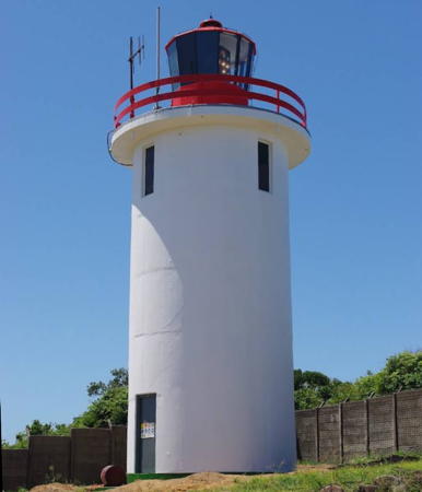
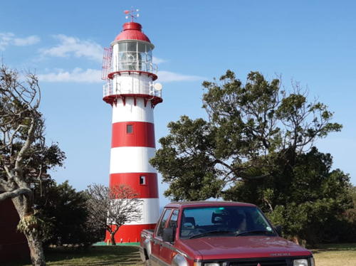
Tugela Bluff Light, Mandini, July 2022
Google Maps photo by Annaleze Lindeque
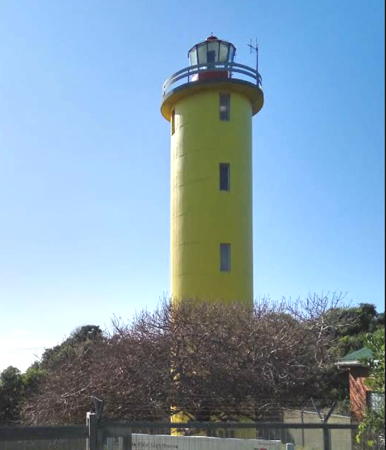
Cape Vidal Light
Cape Vidal Light, St. Lucia, August 2006
ex-Panoramio photo copyright Peet van Heerden; used by permission

North Coast (Umkhanyakude District) Lighthouses
* Jesser Point (Sodwana)
1986. Active; focal plane 61 m (200 ft); four white flashes, separated by 4 s, every 40 s. 11 m (36 ft) round cylindrical concrete tower with lantern and gallery, painted white; lantern painted red. Craig Nattrass has the photo at right, Willie Smit has a photo, Trabas has Brotherston's photo, a 2021 drone view is available, and Google has a good satellite view. A shorter sibling of the Cape Vidal light (next entry). The Sodwana Bay area, near the lighthouse, is very popular with scuba divers; it has the southernmost coral reefs of Africa's east coast. Located on a promontory at the south end of Sodwana Bay. Accessible by road. Site open, tower closed. Site manager: Sodwana Bay National Park. ARLHS SAF-051; Admiralty D6486; NGA 31932.
Cape Vidal
1985. Active; focal plane 65 m (213 ft); white flash every 10 s. 23 m (75 ft) round cylindrical concrete tower with lantern and gallery, painted yellow; lantern painted red. Keeper's house nearby. Peet van Heerden's photo is at the top of this page, Blackburn has a photo, Trabas has Brotherston's photo, Chris Nagel has a 2017 photo, and Google has a good satellite view. The unusual yellow color of this lighthouse was chosen to provide good contrast with the green forest behind the tower. The Cape Vidal area is popular with wildlife enthusiasts and scuba divers. Located about 35 km (22 mi) north northeast of St. Lucia. Viljoen reached the light by a long drive through a wildlife reserve followed by a 3 km (2 mi) hike on the beach. Site open, tower closed. ARLHS SAF-041; Admiralty D6485; NGA 31936.

Richards Bay Area (uThungulu District) Lighthouses
#Cape St. Lucia (2)
1892 (relocated here in 1915). Station established 1906. Destroyed in 2022 but still listed with focal plane 113 m (371 ft); two white flashes every 10 s. 8 m (26 ft) round cast iron tower with lantern and gallery, adjacent to a 1-story keeper's house. Lighthouse painted with black and white horizontal stripes. The lighthouse was adjacent to a large 1-story building. Trabas has Brotherston's closeup photo. This lighthouse was a sibling of the Port Shepstone Light. Both lights were relocated from the Aliwal Shoal area near Scottburgh; this one was originally on the north side of the mouth of the Mahlongwana River, just south of Umkomaas. The original lantern was replaced by a lantern of modern design. Sometime in late 2022 the lighthouse was vandalized and destroyed. Henri Vermaak has a January 2023 photo of the damage and Google has a satellite view. The Admiralty describes the light as "temporarily extinguished" but it's not known yet whether Transnet will restore, replace, or abandon the lighthouse. Located atop a forested sand dune about 20 km (13 mi) south of St. Lucia. Accessible by car over a sand road (4WD required). ARLHS SAF-040; Admiralty D6484; NGA 31940.

Jesser Point Light, St. Lucia, February 2012
Google Maps photo by Craig Nattrass
Richards Bay (2)
2018. Active; focal plane 72 m (236 ft); three white flashes every 15 s. 28 m (92 ft) robust steel post with gallery. Duane Mathers has a December 2018 photo and Google has a satellite view. Richards Bay is a relatively new port at the mouth of the Mhlathuze River, developed in the 1970s to provide port facilities with easier access to Johannesburg. Located atop a bluff off Anglers Road about 3 km (2 mi) northeast of Richards Bay. The entrance to the light station is unmarked. Site open, tower closed. Admiralty D6483; NGA 31944.
* #Richards Bay (1)
1979. Demolished in 2018. This was a 14 m (46 ft) square cylindrical white concrete tower with a circular "watch room," lantern and gallery. Trabas has Brotherston's photo and Mike Leicester has a 2014 photo. Built 200 m (220 yd) from the cliff face in 1979, the tower was only 5 m (17 ft) from toppling over the cliff by late 2017. Rather than have it fall over the cliff, TNPA demolished the lighthouse in April 2018. The lantern was salvaged. ARLHS SAF-057.
* Richards Bay North Breakwater
Date unknown. Active; focal plane 15 m (49 ft); two green flashes every 5 s. 10 m (33 ft) robust post with gallery painted with black and white horizontal bands. Trabas has Douglas Cameron's view from the sea, a photo is available, Wikimedia has a photo, and Google has a street view, but the tower doesn't show in Google's indistinct satellite view. Located on the north breakwater of the Richard's Bay harbor. Accessible by walking the pier from the neighboring Alkantstrand Beach Park, where parking is available. Site open, tower closed. ARLHS SAF-068; Admiralty D6483.45; NGA 31960.
Richards Bay Range Front
Date unknown. Active; focal plane 55 m (180 ft); red light occulting twice every 6 s (continuous red light in the daytime). 51 m (168 ft) white skeletal tower. Patryk Towianski has a photo and Google has a satellite view. This is the entrance range for the harbor. Located on the main quay at Richards Bay. Site and tower closed. Admiralty D6483.2; NGA 31948.
Richards Bay Range Rear
Date unknown. Active; focal plane 73 m (240 ft); white light occulting twice every 6 s (continuous white light in the daytime). 68 m (223 ft) square skeletal tower. Trabas has Erich Hartmann's photo, Mike Chatz has a distant view (tower at the far left), and Google has a street view and a satellite view. Located at the rear of the main quay about 1.3 km (0.8 mi) northwest of the front light. Site and tower closed. Admiralty D6483.21; NGA 31952.
Richards Bay Turning Basin Range Rear (3 towers)
Date unknown. Active; focal plane about 30 m (98 ft); white lights, pattern unknown. Approx. 27 m (89 ft) square skeletal towers with gallery. No photo available. The "turning basin" is actially a dredged basin for a large coal terminal on the south side of the harbor. There are ranges for the centerline and for the east and west limits of the basin. Google has satellite views of the centerline, east limit, and west limit towers. Located near the southern edge of the basin. Site status unknown. Admiralty D6483.71 (centerline), D6483.681 (east limit), and D6483.91 (west limit).
Richards Bay South Breakwater
Date unknown. Active; focal plane 18 m (59 ft); white flash every 3 s. 10 m (33 ft) robust post with gallery painted with red and white horizontal bands. Trabas has Douglas Cameron's view from the sea and Google has a satellite view. Located on the south breakwater of the Richard's Bay harbor. Site and tower closed. Admiralty D6483.4; NGA 31956.
* Durnford Point (2)
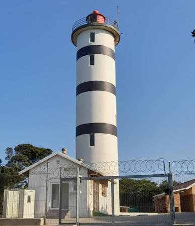
Date unknown (station established 1916). Active; focal plane 49 m (161 ft); four white flashes, in a 3+1 pattern, every 40 s. 12 m (39 ft) round cylindrical white concrete tower with lantern and gallery, attached to a 1-story concrete equipment building. The red lantern is a recent addition seen in the 2017 photo by Thishin Moodley at right and a second photo by John Deminey. Trabas has Brotherston's photo and Google has a satellite view. This lighthouse replaced the original skeletal tower. Viljoen found the station staffed by armed security guards to prevent vandalism. Located on the coast about 25 km (15 mi) southwest of Richards Bay. Site open, tower closed. ARLHS SAF-045; Admiralty D6482; NGA 31964.

Durnford Point Light, Richards Bay, June 2017
Google Maps photo by Thishin Moodley

Tugela Area (iLembe District) Lighthouse
* Tugela Bluff (2)
2007 (station established 1972). Active; focal plane 35 m (115 ft); four white flashes every 30 s. 21 m (69 ft) round cylindrical concrete tower with lantern and gallery. Tower painted white with narrow black horizontal bands, lantern painted red. Annaleze Lindeque's 2022 photo is at the top of this page, Hannes Steyn has a 2008 photo, Wayne Smith has a 2016 closeup, Trabas has Brotherston's photo, and Google has a satellite view and a distant street view. Blackburn has photos of the installation of the lantern in 2006. This lighthouse replaced a skeletal tower. Located on the north side of the mouth of the Tugela River, about 100 km (60 mi) northeast of Durban and 10 km (6 mi) southeast of Tugela. Site open, tower closed. . ARLHS SAF-062; Admiralty D6481; NGA 31972.

Durban (eThekwini Municipality) Lighthouses
Durban (eThekwini) is the busiest port in South Africa and the country's third most populous city. The city proper has a population of about 600,000 but the total population of the eThekwini Municipality is nearly 3.5 million. The city was formerly called Port Natal, since it was the port of the British Natal colony (1843-1910) and the Natal Province of South Africa (1910-1994).
* Umhlanga Rocks
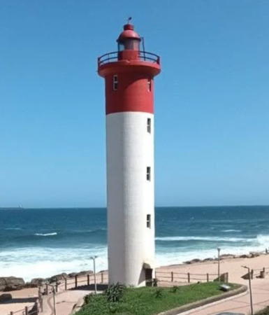
1954. Active; focal plane 24 m (79 ft); three white flashes every 20 s. 21 m (69 ft) round cylindrical concrete tower with lantern and gallery. The upper 1/4 of the lighthouse, including the lantern and gallery, is painted red; the lower 3/4 is painted white. A photo is at right, Adam Ross has a good photo, Trabas has Brotherston's photo, Kwanele Ngwenya has a 2021 photo, Rory MacKay has a 2008 photo, Wikimedia has a photo, James van der Hoven has a street view, and Google has a satellite view. Blackburn has a photo of a storm tide sweeping around the lighthouse in March 2007. This lighthouse and the Cooper Light together replace the old Bluff Light as the lights guiding ships into Durban's harbor. The lighthouse is located on the beach in front of the Oyster Box Hotel, about 15 km (9 mi) north northeast of downtown Durban. Site open, tower closed. . ARLHS SAF-027; Admiralty D6480; NGA 31968.
* Durban Anchorage Beacon
Date unknown. Active; focal plane 16 m (52 ft); quick-flashing white light. 15 m (49 ft) mast adjacent to a 1-story red brick equipment building. Google has a street view and a satellite view. This light marks the northern limit of the Port of Durban; ships are forbidden to anchor south of the light. Located just off the Blue Lagoon Beach at the Atlone Road exit from the Ruth First (M4) expressway. Site open, tower closed. Admiralty D6478; NGA 32000.
 
* Garden Court Hotel (ex-Holiday Inn)
Date unknown. Active (privately maintained); focal plane 109 m (358 ft); continuous white light. Light mounted atop a high rise hotel on Durban's North Beach waterfront. Trabas has Capt. Peter Mosselberger's photo (taken from the rear of the building) and Google has a street view and a satellite view. The light is listed by the Admiralty and NGA as "Holiday Inn" but the building is now the Garden Court South Beach Hotel. Located on the beachfront between Brighton Road and Anton Lambede Street. Site open. Admiralty D6461.5; NGA 31975.
* 88 on Field (ex-Anglo-American Building)
1986. Active (privately maintained); focal plane 144 m (472 ft); white flash every 7 s. Light mounted on a tall mast atop a 26-story glass and steel office building on the Durban waterfront. Trabas has a photo of the light tower by Capt. Peter Mosselberger, and Google has a street view and a satellite view. The building is now called 88 on Field; the light lists call it the Anglo-American Building after its original owner, Anglo-American Properties Services. Located at 88 Joe Slovo (formerly Field) Street, Durban. Site open. Admiralty D6461; NGA 31974.
Durban North Breakwater (3?)
2009 (station established 1885). Active; focal plane 14 m (46 ft); green flash every 3 s. 10 m (33 ft) steel post, painted green. Trabas has Erich Hartmann's photo, a 2021 photo is available, Barend Rensburg has a view from the sea, and Google has an indistinct satellite view. This light replaced a 10 m (33 ft) square skeletal tower with gallery centered on a round 1-story concrete equipment room. Located at the end of the north breakwater at the mouth of the Umgeni River. Site status unknown. Admiralty D6466; NGA 31979.
Umhlanga Rocks Light
Umhlanga Rocks Light, Durban, May 2007
Flickr Creative Commons photo
by jossthorp
Durban South Breakwater (3?)
2009 (station established 1895). Active; focal plane 14 m (46 ft); two white flashes every 5 s. 8 m (26 ft) steel post, painted red. Trabas has Douglas Cameron's photo and Google has a satellite view. This light replaced a 10 m (33 ft) square skeletal tower with gallery centered on a round 1-story concrete equipment room. The original light was listed as a "purple tower." Located at the end of the south breakwater at the mouth of the Umgeni River. Accessible only by boat. Site and tower closed. ARLHS SAF-061; Admiralty D6464; NGA 31978.
* Durban Bluff (Port Natal)
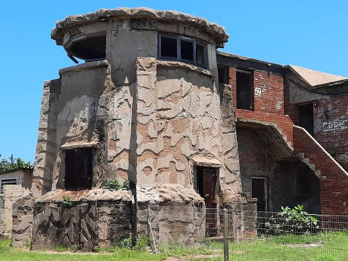
1867. Inactive since 1940. This was a 24.5 m (81 ft) cast iron tower with lantern and gallery. Huelse has a postcard view of the original Bluff lighthouse and an additional postcard view is available. The lighthouse was encased in concrete in 1932, converting it into a buttressed tower similar to the Hill lighthouse at Port Elizabeth (see the Eastern Cape page). In 1941 the lighthouse was truncated because it stood in the line of fire of coastal defense artillery. About 7 m (23 ft) of the tower survives. Jenny Saunders has the 2021 photo seen at right, Graham Leslie McCallum has a photo, a closeup photo is available, and Google has a satellite view. Located at the end of the bluff on the south side of the harbor entrance. Site open, tower closed. ARLHS SAF-070.
Durban Channel Range Front
Date unknown. Active; focal plane 21 m (69 ft); red light, 1 s on, 1 s off. Approx. 17 m (56 ft) square skeletal tower carrying a triangular slatted daymark pointed up. Daymark painted yellow. Trabas has Capt. Peter Mosselberger's photo and Google has a satellite view. This range guides vessels in the approach channel. Located near the east end of the Durban docks. Site and tower closed. Admiralty D6472; NGA 31984.
 

Ruins of Durban Bluff Light, Durban, January 2021
Google Maps photo by Jenny Saunders
 
Durban Channel Range Rear
Date unknown. Active; focal plane 43 m (141 ft); white light occulting once every 4 s. Approx. 17 m (56 ft) square skeletal tower carrying a large triangular slatted daymark pointed down. Daymark painted yellow. Trabas has Capt. Peter Mosselberger's photo and Google has a satellite view. Located on a steep slope on the south edge of the dockyard. Site and tower closed. Admiralty D6472.1; NGA 31988.
Durban Entrance Channel Leading
2011. Active; focal plane 43 m (141 ft); continuous light, white, red or green depending on direction. 41 m (135 ft) square skeletal tower with gallery. No photo available but Google has a satellite view. Vessels entering Durban make a slight turn (2.2° to starboard) as they reach the entrance; this light guides them on the new bearing. Located in a crowded dockyard on the south side of the harbor. Site and tower closed. Admiralty D6472.2.
Island View Channel Range Front
Date unknown. Active; focal plane 22 m (72 ft); white flash every 3 s. Approx. 20 m (66 ft) square skeletal tower, painted black and carrying a yellow triangular daymark, point up. No photo available but Bing has a satellite view. Located in an oil terminal in Durban harbor. Site and tower closed. Admiralty D6475; NGA 31992.
Island View Channel Range Rear
Date unknown. Active; focal plane 25 m (82 ft); red light occulting once every 4 s. Approx. 24 m (79 ft) square skeletal tower, painted black and carrying a yellow triangular daymark, point down. Google has a distant street view and Bung has a fuzzy satellite view. Located 84 m (275 ft) southwest of the front light. Site and tower closed. Admiralty D6475.1; NGA 31996.
* Cooper (Coopers, Durban Bluff)
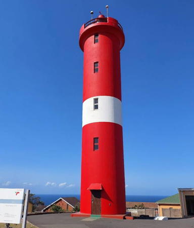
1953. Active; focal plane 133 m (436 ft); white flash every 10 s. 21 m (69 ft) round cylindrical concrete tower, painted red with a white horizontal band. A photo by Danie White is at right, Trabas has Brotherston's closeup, Danie White has a 2017 photo, and Google has a street view and a satellite view. Named in honor of South Africa's longtime (1916-1941) lighthouse engineer H.C.L. Cooper, this lighthouse is built on the Durban Bluff, a long seaside ridge on the south side of the city. It replaced the historic Durban Bluff lighthouse, built in 1867 and demolished in 1942. The modern lighthouse is about 5 km (3 mi) southwest of the original light station, in the 600 block of Marine Drive in Brighton Beach. It is easily accessible, but for some reason photos of it are quite scarce on the Internet. Site open, tower closed. . ARLHS SAF-011; Admiralty D6458; NGA 32020.

Cooper Light, Durban, July 2017
Google Maps photo
by Danie White

Hibiscus Coast (Ugu District) Lighthouses
* Green Point (Greenpoint, Clansthal)
1905. Active; focal plane 85 m (279 ft); two white flashes every 15 s; a continuous red light is shown over the Aliwal Shoal to the east southeast. 21 m (69 ft) round cast iron tower with lantern and gallery, painted with red and white horizontal bands; Fresnel lens in use. This is a staffed station. Greg Goodchild's 2021 photo is at right, Debbie Woods has a 2020 closeup, Trabas has Brotherston's photo, Jeffrey Shemmans has a good 2018 photo, Huelse has a historic postcard view, and Google has a satellite view and a distant street view from the coastal road (R102). Not to be confused with the famous Green Point lighthouse of Cape Town (see the Western and Northern Cape page). The Aliwal Shoal is one of the most notorious reefs of South Africa's Indian Ocean coast. In 1892 two cast iron towers were installed to warn of the shoal; one was at Scottburgh and the other on the north side of the Mahlongwana River just south of Umkomaas. These towers proved inadequate, so this taller lighthouse was built at a location between the two older towers. The Scottburgh Light was relocated to Port Shepstone (see below) and the Mahlongwana Light was reinstalled at Cape St. Lucia (see above). The lighthouse was restored in a major project in 2007; Blackburn has photos. Located on a bluff above the R102 coastal highway in Ezembeni, a small settlement between Scottburgh and Umkomaas, about 60 km (37.5 mi) southwest of Durban. Site open, tower closed. ARLHS SAF-014; Admiralty D6454; NGA 32032.
* Ifafa (Ifafa Beach)
1980. Active; focal plane 35 m (115 ft); three white flashes every 30 s. 23 m (75 ft) triangular skeletal tower with gallery. The tower also carries a triangular slatted daymark. Trabas has Brotherston's photo, Mike Leicester has a closeup photo, and Google has a street view and a satellite view. Located on a bluff at Ifafa Beach, a coastal resort about 100 km (60 mi) southwest of Durban. Site open, tower closed. ARLHS SAF-016; Admiralty D6452; NGA 32040.

Green Point Light, Ezembeni, August 2021
Google Maps photo by Greg Goodchild
**** Port Shepstone (2)
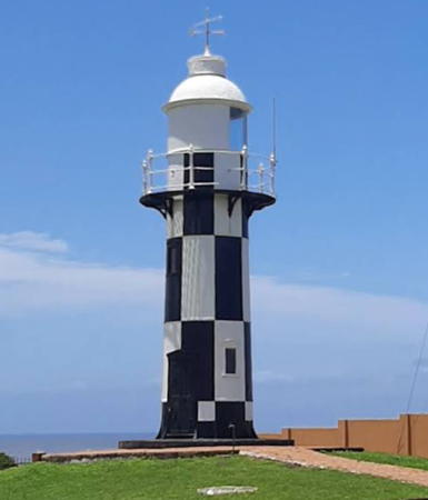
1892 (relocated here in 1906). Station established 1895. Active; focal plane 24 m (79 ft); white flash every 6 s. 11 m (36 ft) round cast iron tower with lantern and gallery, painted in a black and white checkerboard pattern; lantern painted white. A photo is at right, Craig Van Rensburg has a 2018 closeup photo, Jenny Baxen has a 2022 photo, Trabas has a photo, and Google has a street view and a satellite view. This lighthouse was relocated from Scottburgh, about 65 km (40 mi) to the north; it replaced a light on a mast. Transnet has developed the light station with a gift shop and tea room, Hibiscus Coast Tourism operates a visitor center, and accommodations are planned for the future. Located on a headland on the southern side of the mouth of the Mzimkulu River in Port Shepstone, a town of about 35,000 residents. Site open, tower open daily to guided tours (entry fee). . ARLHS SAF-021; Admiralty D6450; NGA 32044.
*** North Sand Bluff (Port Edward) (2)
1999 (station established 1968). Active; focal plane 38 m (125 ft); two white flashes, separated by 3 s, every 10 s. 22 m (72 ft) round cylindrical concrete tower with lantern and gallery, painted white; lantern painted red. Two modern cottages provide overnight accommodations. Trabas has an excellent photo by station manager Dave Watson, Arina Clarke has a 2021 photo, Hugh Glen has a good 2008 photo, and Google has a street view and a satellite view. Transnet has developed the light station; in addition to the cottages there is a small maritime museum, a gift shop, a coffee shop, swimming pool, and playground. Located on a bluff among seaside cottages north of the Mtamvuna River in Port Edward, a resort town at the southernmost point of KwaZulu Natal. Site open, tower open on weekdays to guided tours. ARLHS SAF-019; Admiralty D6448; NGA 32048.

Information available on lost lighthouses:

Notable faux lighthouses:

  •  

Port Shepstone Light, April 2007
Wikimedia Creative Commons photo by Ossewa

Adjoining pages: North: Southern Mozambique | West: Eastern Cape

Return to the Lighthouse Directory index | Ratings key

Posted June 2, 2005. Checked and revised February 6, 2024. Lighthouses: 29. Site copyright 2024 Russ Rowlett and the University of North Carolina at Chapel Hill.