Lighthouses of South Africa: Western and Northern Cape

The Republic of South Africa occupies the southern end of the African continent, including the famous capes of Good Hope and Agulhas. During the colonial era Dutch and British colonists struggled for many years to control the country, but by the mid 1800s the entire coastline was under British control. As a result South Africa's lighthouse heritage is British.

The country was formed in 1910 as the Union of South Africa, an autonomous British dominion combining the Cape, Transvaal and Natal colonies and the Orange Free State republic. Full independence was granted in 1931 and the Union became the Republic in 1961.

South Africa is divided into nine provinces and the provinces are divided into districts and municipalities. This page describes lighthouses of the the provinces of Western Cape and Northern Cape. Located at the southern tip of Africa, these provinces face southeast on the Indian Ocean and west on the Atlantic Ocean. There are also pages for the provinces of Eastern Cape and KwaZulu-Natal.

Lighthouses in South Africa are operated by the Lighthouses and Navigational Systems division of the Transnet National Ports Authority (TNPA). Some are still staffed. Some of the larger and more accessible light stations have been developed for tourism by the Transnet business office.

Official languages in South Africa include English, Afrikaans, and nine native African languages. In Afrikaans the word for a lighthouse is vuurtoring; eiland is an island, kaap is a cape, punt is a point of land, baai is a bay, and klip is a rock. In the Xhosa language common in the Western Cape indlu yokukhanya ("house of light") is a lighthouse.

ARLHS numbers are from the ARLHS World List of Lights. Admiralty numbers are from volume D of the Admiralty List of Lights & Fog Signals. U.S. NGA List numbers are from Publication 113 for the Atlantic coast and 112 for the Indian Ocean coast.

General Sources
Charmaine Blackburn - Lighthouses
Photos posted on Flickr.com by Ms. Blackburn. Her blog has additional photos.
Online List of Lights - South Africa
Photos posted by Alexander Trabas. Many of the photos for this area are by Don Brotherston, a Johannesburg photographer.
Leuchttürme in Südafrika
Photos posted by Bernd Claußen.
Lighthouses in South Africa
Photos by various photographers available from Wikimedia.
Afrikanische Leuchttürme auf historischen Postkarten
Postcards from the collection of Klaus Huelse.
GPSNavigationalCharts
Navigational chart information for South Africa.
Navionics Charts
Navigation chart information for South Africa.


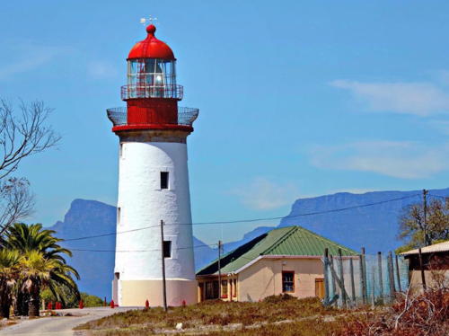
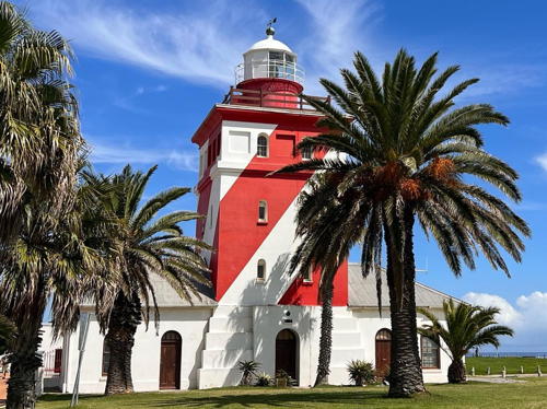
Green Point Light, Cape Town, November 2006
Wikimedia Creative Commons photo by Hilton Teper


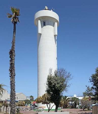
Milnerton Light, Milnerton, December 2022
Google Maps street view

Western Cape Province Lighthouses

Garden Route District (Mossel Bay Area) Lighthouses
Mossel Bay is a city of about 100,000 residents on the southern coast of South Africa about 400 km (250 mi) east of Cape Town and the same distance west of Port Elizabeth.

Cape Seal (2)
2013 (station established 1950). Active; focal plane 143 m (469 ft); two white flashes every 30 s. 10 m (33 ft) square skeletal tower with gallery adjacent to a 1-story concrete equipment building. Tower painted white. No closeup photo of the newer lighthouse is available, but Michael Gerlt has a distant drone view and Google has a satellite view. This modest light has the highest focal plane of any South African lighthouse. Cape Seal is a mountain connected to the mainland by a narrow isthmus and set aside as a nature reserve. The lighthouse is accessible by a hiking trail from Whale Rock Beach. Located about 12 km (7.5 mi) southeast of Plettenberg Bay. Site open but difficult to reach, tower closed. Site manager: Cape Nature (Robberg Nature Reserve). ARLHS SAF-038; Admiralty D6384; NGA 112-32152.
* [Knysna Range Front, Fountain Point, Eastern Head Beacon]
Date unknown. Active; focal plane about 8 m (26 ft); white flash every 3 s. Approx. 3 m (10 ft) conical solid stone tower, painted white. A photo is available, Casper Scholly has a street view, Ilse Wiespointner has a 2022 photo, and Google has an indistinct satellite view. The range guides vessels through the narrow entrance to the estuary of the Knysna River. The rear light is on a mast. Located on a rocky point on the east side of the entrance in Knysna, a city of about 75,000 residents. Parking is available. Site open, tower closed. Admiralty D6383.
* [Voorbaai Range Rear]
Date unknown. Active; focal plane unknown; continuous white light. 15 m (49 ft) steel post. Google has a street view and a satellite view. The front light is on an identical post 73 m (240 ft) to the east southeast. Located on Hannes Pienaar Street at Bertie Anderson Street in Mossel Bay. Site open, tower closed. Admiralty D6381.1; NGA 112-32172.
* Mossel Bay (Mosselbaai) Breakwater
Date unknown. Active; focal plane 12 m (39 ft); quick-flashing red light. 9 m (30 ft) square pyramidal skeletal tower with lantern and gallery. Entire lighthouse painted red. Shailendra Kamal has a 2011 photo, another photo is available, and Google has an indistinct satellite view. Located at the end of the east breakwater of Mossel Bay harbor. Accessible by walking the pier. Site open, tower closed. Admiralty D6379; NGA 112-32184.
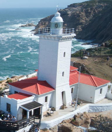
**** Cape St. Blaize (Mossel Bay)
1864. Active; focal plane 73 m (240 ft); two quick white flashes every 15 s. 14 m (46 ft) square cylindrical brick tower with lantern and gallery, rising from a 1-story keeper's house. Additional keeper's cottage available for overnight accommodations. Entire building painted white with red trim. Fog horn (Morse code "F," two short blasts, a long and a short, every 60 s). Wikimedia has the photo by P.H. Parsons seen at right, Viljoen has a photo, Trabas has Rainer Arndt's photo, Bob Adams has a photo, another photo is available, Huelse has a historic postcard view, and Google has a satellite view. The eastward-pointing Cape St. Blaize, named by Diaz in 1488, shelters the southwestern entrance to Mossel Bay. Although the lighthouse is automated it is staffed by a crew of three who operate a radio communications center and make weather observations. Transnet has developed the station with a cottage for rental and a gift shop. Located on the cape in the town of Mossel Bay (Mosselbaai). Site open, tower open to guided tours Monday through Friday. . ARLHS SAF-010; Admiralty D6378; NGA 112-32192.

Cape St. Blaize Light, Mossel Bay, December 2012
Wikimedia Creative Commons photo by P.H. Parsons
* Ystervark Point (Ystervarkpunt) (2)
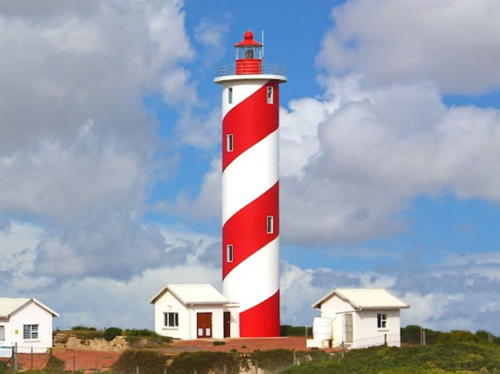
2006 (station established 1964). Active; focal plane 50 m (164 ft); white flash every 10 s. 22 m (72 ft) round cylindrical concrete tower, painted with red and white spiral bands. B. Van Zyl's photo is at right, Trabas has Brotherston's closeup, Claußen has 2008 photos, and Google has a satellite view. The lighthouse replaced a square skeletal tower seen in Viljoen's photo but later removed. Located on a promontory about 80 km (50 mi) southwest of Mossel Bay. Site open, tower closed. ARLHS SAF-073; Admiralty D6374; NGA 112-32196.
* [Stillbaai Jetty]
Date unknown. Active; focal plane 4 m (13 ft); red light, 1 s on, 1 s off. 3 m (10 ft) round metal tower painted red. Google has a street view and a satellite view. Located on a short pier at Stillbaai, a small town of about 3500 residents. Site open, tower closed. Admiralty D6372; NGA 112-32200.

Overberg District Lighthouses
* Cape Infanta
1979. Active; focal plane 53 m (174 ft); three white flashes every 20 s. 15 m (49 ft) triangular skeletal tower with lantern and gallery. Tower painted white, lantern red. The tower also carries a square slatted daymark. Keeper's house and other station buildings. Google has a satellite view. The cape is part of Cape Nature's De Hoop Nature Reserve. Located on the cape, about 10 km (6 mi) south of Infanta-on-River. Accessible by road. Site open, tower closed. ARLHS SAF-036; Admiralty D6371; NGA 112-32204.
* Struispunt (Waenhuiskrans)
2004 (tower built in the early 1900s). Active; focal plane 12 m (39 ft); three white flashes every 15 s. 13 m (43 ft) square pyramidal solid stone beacon. Formerly mounted above the light was a spherical "beachball" daymark with red and white vertical stripes. Albert Geldenhuys has a 2023 photo, Viljoen has a 2016 photo, and Google has an indistinct satellite view. The solar-powered light was added to this historic daybeacon in March 2004. Located in the surf off a rocky promontory at Waenhuiskrans, about 3 km (2 mi) south of Arniston. Site open, tower accessible at low tide. Admiralty D6370.4; NGA 112-32204.5.

Ystervark Point Light, Gouritz, November 2017
Google Maps photo by B Van Zyl
* [Struisbaai (Struis Bay)]
Date unknown. Active; focal plane 6 m (20 ft); white flash every 3 s. 3 m (10 ft) round metal tower painted with red and white horizontal bands. Trabas has Brotherston's closeup photo and Google has a satellite view. Located on the breakwater at Struisbaai, a small town of about 4000 residents located 4 km (2.5 mi) northeast of Cape Agulhas. Accessible by walking the pier. Site open, tower closed. Admiralty D6370.1; NGA 112-32206.
**** Cape Agulhas
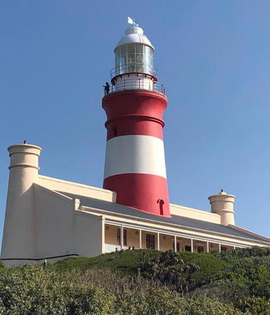
1849. Reactivated (inactive 1968-1988); focal plane 31 m (102 ft); white flash every 5 s. 27 m (89 ft) sandstone tower with lantern and gallery, rising through the center of a 1-story keeper's house. Rotating 1st order Fresnel lens in use. Building painted white with two red horizontal bands on the tower. A photo by Brian Watrous is at right, John Hartnup has a similar photo taken in 2009, Jane and Ben Danielsen have a photo, Trabas has Brotherston's photo, Pieter Rinkel has a fine photo, Wikimedia has photos, Samantha Allum has a 2022 photo, and Google has a street view and a good satellite view. This is South Africa's third oldest light station and second oldest surviving lighthouse (after Green Point). The lighthouse marks the southernmost point of Africa at latitude 34°50' S and the junction of the Atlantic and Indian Oceans at longtitude 20°01' E; the ultimate tip of the continent is 1 km (0.6 mi) west southwest of the lighthouse. This historic light, surely one of the world's great lighthouses, was deactivated in 1968 when deterioration of the sandstone walls made the tower appear unsafe. Twenty years of public effort led by the Bredasdorp Shipwreck Museum secured a complete restoration and reactivation in 1988. Today the keeper's house includes a lighthouse museum and a restaurant. Lighthouse Digest reported on the light's 150th anniversary celebration in March 1999, which was also the official opening of Agulhas National Park. In 2012 Transnet announced a 4.2 million rand ($504,000) project to restore and upgrade the lighthouse. Located on the point of the cape, about 8 km (5 mi) south of Hotagterklip. Site open, tower open daily year round (admission fee). Site manager: South African National Parks (Agulhas National Park). . ARLHS SAF-004; Admiralty D6370; NGA 112-32208.
* Quoin Point
1955. Active; focal plane 34 m (112 ft); two white flashes, separated by 3 s, every 10 s. 22 m (72 ft) square pyramidal skeletal tower with gallery, carrying a red diamond-shaped daymark. 2-story wood keeper's house, painted white. Chris Swiegers has a 2017 photo and a more distant view, and Google has a satellite view. Quoin Point is the western point of the Cape Agulhas peninsula, about 34 km (21 mi) west northwest of the cape. The area is protected as the Quoin Point Provincial Nature Reserve. Located about 3 km (2 mi) south of Die Dam. Accessible by road but 4WD is required. Site open, tower closed. ARLHS SAF-022; Admiralty D6332; NGA 112-32212.

Cape Agulhas Light, August 2019
Instagram photo by Brian Watrous
**** Danger Point (Birkenhead)
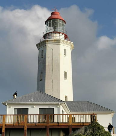
1895. Active; focal plane 45 m (148 ft); three long (2 s) white flashes every 40 s. 17 m (56 ft) octagonal brick tower with lantern and gallery. Lighthouse painted white; lantern dome is red. 1-story keeper's house available for overnight accommodations. Fog horn (Morse code "D," one long blast and two short ones, every 15 s). Phil Parsons's photo is at right, Trabas has Brotherston's closeup, a fine closeup photo is available, Stiaan Schoeman has a photo, Patrick Yeadon has a 2022 photo, Viljoen has a photo, Claußen has photos, Wikimedia has a photo, and Google has a street view and a satellite view. The name Birkenhead memorializes the British troopship Birkenhead, which wrecked on the point in 1852 with the loss of 450 lives. The light was modernized in 1970, when the original 1st order Fresnel lens was replaced by a rotating 250 mm aerobeacon. Transnet has developed the light with one apartment for rent and a visitor center and gift shop. The site is also popular for whale watching. Located on a sharp promontory at Birkenhead, about 10 km (6 mi) southwest of Gans Bay (Gansbaai) and roughly halfway between Cape Hangklip and Cape Agulhas. Site open, tower open to guided tours Monday through Friday except public holidays. . ARLHS SAF-012; Admiralty D6320; NGA 112-32216.
* Gansbaai South Breakwater
Date unknown. Active; focal plane 8 m (26 ft); quick-flashing green light. 5 m (17 ft) square cylindrical concrete tower, painted white. Gary Crouse has a street view and Google has a distant satellite view. Located at the end of the south breakwater at Gansbaai, a town of about 12,000 residnets. Accessible in good weather by walking the pier. Site open, tower closed. Admiralty D6304; NGA 112-32236.
* Gansbaai North Breakwater
Date unknown. Active; focal plane 8 m (26 ft); quick-flashing red light. 5 m (17 ft) square cylindrical concrete tower, painted white. Google has a closeup street view and a distant satellite view. Located at the end of the north breakwater at Gansbaai. Accessible in good weather by walking the pier. Site open, tower closed. Admiralty D6300; NGA 112-32232.
* Hermanus Breakwater
Date unknown. Active; focal plane 7 m (23 ft); red flash every 3 s. 5 m (17 ft) square cylindrical concrete tower, painted white. Bekezela Sikwila has a closeup street view and Google has a satellite view. Located at the end of the breakwater at Hermanus, a town of about 5600 residents. Accessible in good weather by walking the pier. Site open, tower closed. Admiralty D6290; NGA 112-32240.
Danger Point Light
Danger Point Light, March 2010
Flickr Creative Commons photo by Phil Parsons
* Cape Hangklip
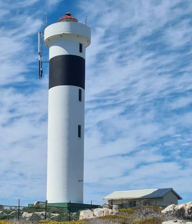
1960. Active; focal plane 33 m (108 ft); white flash every 10 s. 22 m (72 ft) concrete tower with lantern and gallery with a small lantern and gallery, painted white with a single black horizontal band near the top; lantern is red. Ilse Halgryn's 2021 photo is at right, Trabas has Brotherston's foggy closeup, Andre Nel has a 2022 photo, Claußen has photos, Tim Walker has a fine closeup, a distant photo is available, and Google has a street view and a satellite view. This tower is a sibling of the Milnerton Light, which was built in the same year. Located on the cape at the eastern entrance to False Bay about 30 km (20 mi) west of Kleinmond. Accessible by unpaved (and unmarked) roads from Pringle Bay. Site open, tower closed. . ARLHS SAF-005; Admiralty D6280; NGA 112-32244.

Cape Town Metropolitan Municipality: False Bay and Cape Peninsula Lighthouses
* [Gordan's Bay Harbour West Breakwater]
Date unknown. Active; focal plane 5 m (17 ft); quick-flashing green light. 4 m (13 ft) square concrete tower painted white with a green horizontal band. Roelf Diedericks has a street view and Google has a satellite view. Located at the end of the west breakwater at Gordon's Bay, a recreational harbor in the northeastern corner of False Bay. Accessible by walking the pier. Site open, tower closed. Admiralty D6262; NGA 112-32248.
* [Gordan's Bay Harbour East Breakwater]
Date unknown. Active; focal plane 5 m (17 ft); red flash every 2 s. 4 m (13 ft) square concrete tower painted white with a red horizontal band. Garth Endley has a photo and Google has a satellite view. Located at the end of the east breakwater at Gordon's Bay, a recreational harbor in the northeastern corner of False Bay. Accessible by walking the pier. Site open, tower closed. Admiralty D6260; NGA 112-32252.
Seal Island (1)
Date unknown. Inactive. Approx. 8 m (26 ft) round cylindrical stone tower. A photo is available and Google has a satellite view. Another photo also shows the active light (focal plane about 22 m (72 ft); white flash every 2 s) on a mast. The photo captions, "Seal Island at Mossel Bay," appear to be in error; there is a Seal Island at Mossel Bay but there is no light there. Well named, the island is a nature reserve for seals. Located on a rocky islet at the north end of False Bay. Accessible only by boat. Site and tower closed. Active light: Admiralty D6176; NGA 32319.

Cape Hangklip Light, Overstrand, September 2021
Google Maps photo by Ilse Halgryn
* [Kalk Bay Breakwater]
1919. Active; focal plane 7 m (23 ft); one long (2.5 s) white flash every 15 s. 5 m (17 ft) round tapered stone tower. Upper third of the lighthouse painted red, lower portion white. A 2009 photo is available, Trabas has a closeup by Günther Hess, Mitch Lee has a street view, and Google has a satellite view. Located at the end of the south breakwater at Kalk Bay, a recreational harbor near Vishoek (Fish Hook) on the west side of False Bay. Accessible by walking the pier. Site open, tower closed. Admiralty D6200; NGA 112-32272.
Roman Rock
1861. Active; focal plane 17 m (56 ft); quick white flash every 6 s. 14 m (46 ft) cast iron tower with flared top, lantern and gallery, mounted on a circular stone pedestal. Entire lighthouse painted white. Blackburn has a fine 2009 photo, Trabas has Brotherston's photo, a sea kayaker has posted a dramatic closeup, Leon Jacobs has a 2021 photo, and Google has a satellite view. Claußen has a 2008 photo in which the tower is surrounded by scaffolding for painting and restoration. The tower was prefabricated in England but it took four years to build the base on a waveswept rock in False Bay. The lighthouse was extensively renovated in 1992 and the original lantern was replaced with a modern lantern and light. In 2015 the power supply was upgraded and the light strengthened. Located on a rock in False Bay about 2 km (1.6 mi) east of the Simonstown Dockyard Light. Accessible only by boat; visible distantly from Simonstown. Site and tower closed. . ARLHS SAF-024; Admiralty D6140; NGA 112-32280.
Simon's Town (Simonstown) Dockyard
1910. Active; focal plane 17 m (56 ft); white neon light, 2.5 s on, 1.5 s off. 13 m (43 ft) stone tower with gallery, unpainted; lantern removed. Trabas has Erich Hartmann's view from the sea and Google has a satellite view. Simon's Town (Simonstad), on the east side of the Cape Peninsula facing False Bay - a location sheltered from the wind - was the traditional home port of the Royal Navy squadron in South Africa. Today the East Dockyard, completed in 1910, is an important base for the South African Navy. The lighthouse is located at the "bullnose," or elbow, of the breakwater enclosing the dockyard. Site and tower closed, but there are good views from shore. Site manager: South African Navy. ARLHS SAF-069; Admiralty D6144; NGA 112-32300.
Cape Point (2) (Dias Point, Cape of Good Hope)
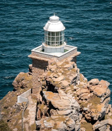
1919 (H.C. Cooper); station established 1860. Active; focal plane 87 m (285 ft); two white flashes, a 12.3 s pause, and then one more white flash, every 30 s, shown to the northwest; also a continuous red light is shown to the south from the base of the tower at a focal plane of 77 m (253 ft). 9 m (30 ft) square cylindrical stone tower with lantern and gallery. Tower is unpainted stone; lantern painted white with a red dome. Bernhard Hecker's photo is at right, Joe Viljoen has a page with a photo, Google has a spectacular street view by Nic Burger, Trabas has a good photo by Günther Hess, Claußen has a photo, Huelse has a historic postcard view, and Google has a satellite view and a distant street view. The original lighthouse was built too high on the cliffs, so its light could not be seen through low clouds or fog. Construction of the new tower took 5 years under very difficult conditions. Located atop a steep pinnacle above Cape Point. It is difficult to reach the lighthouse, but there are good views from the end of the Dias Look Out Trail and nearly all photos are taken from that point. Site and tower closed. Site manager: South African National Parks (Table Mountain National Park). . ARLHS SAF-007; Admiralty D6120; NGA 112-32324.

1919 Cape Point Light, Cape of Good Hope, June 2005
Wikimedia Creative Commons photo by Bernhard Hecker
* Cape Point (1) (Cape Maclear, Cape of Good Hope)
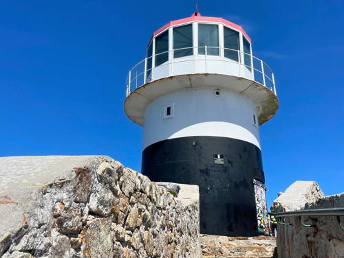
1860. Inactive since 1919. 8 m (27 ft) round cylindrical cast iron tower with lantern and gallery. The upper half of the lighthouse is painted white and the lower half black; the lantern is white with a red dome. Matt Kieffer's photo is at right, Stuart Henderson has a good photo, Gao Jiangyou has a closeup, Claußen has photos, Wikimedia has several photos, Huelse has a historic postcard view, Sundiep Mahabeer has a closeup street view, and Google has a satellite view. The tower was prefabricated in England. Named the Cape of Storms by Bartholomeu Diaz in 1488, the Cape of Good Hope was renamed by the explorer's patrons in Portugal. It is not the southernmost point of Africa; Cape Agulhas has that distinction. Nonetheless, this is one the world's great capes and it has probably the most visited lighthouse in South Africa. The historic original lighthouse is actually atop Cape Maclear, the center and highest of the three headlands at the end of the Cape Peninsula. At a focal plane of 249 m (816 ft) it proved to be too high, as its light was often blocked by low clouds. The old light station is now "the centralised monitoring point for all the lighthouses on the coast of South Africa," according to the web site of Table Mountain National Park, which includes the entire Cape Point area. It is difficult to image a more spectacular location for a lighthouse. Located about 60 km (40 mi) south of Cape Town beyond the end of Cape Point Road; a paved walkway and stairway and a funicular railway provide access to a viewpoint at the lighthouse. Site and funicular open daily, tower closed. Site manager: South African National Parks (Table Mountain National Park). . ARLHS SAF-008.

1860 Cape Point Light, Cape of Good Hope, June 2018
Flickr Creative Commons photo by Matt Kieffer
**** Slangkop Point (Slangkoppunt)
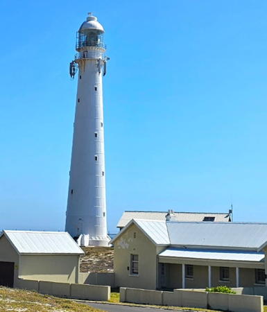
1919. Active; focal plane 40 m (131 ft); four white flashes, separated by 4 s, every 30 s. 33 m (108 ft) round cast iron tower with lantern and gallery. Entire structure painted white. A photo by Leon Jacobs is at right, Danie van der Merwe has a good photo, another good photo is available, Wikimedia has several photos, Trabas has Brotherston's photo, Viljoen has a photo, and Google has a street view and a satellite view. The lighthouse was prefabricated in England by Chance Brothers. The station includes several buildings, one of them a modern conference facility and another used as a visitor center and gift shop. This lighthouse marks a dangerous promontory on the west side of the Cape Peninsula, facing the open Atlantic. The site is popular for weddings. Located near the village of Kommetjie, about 30 km (20 mi) south of Cape Town. Accessible by road. Site open, tower open to guided tours Monday through Friday except on public holidays. . ARLHS SAF-026; Admiralty D6110; NGA 113-26064.

Cape Town Metropolitan Municipality: Cape Town and Table Bay Lighthouses
**** Green Point ("Mouille Point", Cape Town, Kaapstad)
1824 (Herman Shutte). Active; focal plane 19 m (62 ft); white flash every 10 s. 16 m (52 ft) square 4-story brick tower with lantern and gallery, rising from the center of a 1-story keeper's house. Building painted white; the north and west faces of the light tower are painted with bold red and white diagonal bands; watch room painted red, lantern white. Fog horn (blast every 30 s). Wikimedia's spectacular photo by Hilton Teper appears at the top of this page, Trabas has Erich Hartmann's excellent photo, Leon Jacobs has a 2021 photo showing the lighthouse freshly repainted, Omar Hamdi has a photo taken inside the lantern room, Wikimedia has many photos, Huelse has a historic postcard view, and Google has a street view and a satellite view. South Africa's oldest lighthouse was increased in height by addition of the top story of the tower in 1865. Today the lighthouse is part of the headquarters of the Lighthouse Services Division of the National Ports Authority, and the former keeper's house includes a small conference facility and a gift shop and visitor center. The 200th anniversary of the lighthouse was celebrated in April 2024. The lighthouse is often called Mouille Point Light, although there was a different lighthouse with that name (next entry) from 1842 to 1908. There is another Green Point Light in KwaZulu Natal (see Eastern South Africa). Located at 8001 Western Cape Beach Road in Cape Town. Site open, tower open to guided tours Monday through Friday. . ARLHS SAF-047; Admiralty D5900; NGA 113-25980.

Slangkop Point Light, Kommetjie, March 2021
Google Maps photo by Leon Jaacobs
* Mouille (Mouillé) Point (2)
1865 (station established 1842). Inactive since 1908. The lighthouse, a brick tower with lantern and gallery about 11 m (36 ft) tall, was South Africa's second lighthouse. Klaus Huelse has a historic postcard view. This lighthouse stood at the northwestern end of the Cape Town waterfront. Most of the tower was removed by the 1920s, but the 1-story base, about 3 m (10 ft) high, has been restored recently and can be seen in front of a restaurant. Tower painted white. Claußen has a 2008 closeup photo, Michael Manson-Kullin has a street view and Google has a satellite view. The first lighthouse has been described as a "squat" square stone tower. Located on Beach Road at Ganger Bay, just north of the waterfront. Site open. Site manager: Cape Town Hotel School Restaurant. ARLHS SAF-067.
Cape Town Breakwater (4)
Date unknown (late 1930s?) (station established 1801). Active; focal plane 13 m (43 ft); green flash every 2 s. 10 m (33 ft) square skeletal tower with lantern and gallery. Lighthouse painted green; lantern roof painted white. Trabas has an excellent photo by Erich Hartmann, a closeup photo is available, and Google has a satellite view and a very distant street view. This lighthouse replaced a post light installed in 1916; earlier there was a light on a tramway. Located at the end of the main breakwater on the northwest side of the harbor. Site and tower closed. ARLHS SAF-072; Admiralty D5930; NGA 113-25988.
Cape Town Entrance (Duncan Dock) Range Front
Date unknown. Active; focal plane 60 m (197 ft); quick-flashing red light. Approx. 55 m (180 ft) triangular skeletal tower painted with red and white horizontal bands. Trabas has Erich Hartmann's photo and Google has a street view and a satellite view. Located on the main quay of Cape Town Harbour. Site and tower closed but there's a good view from Heerengracht Street just outside the dockyard fence. Admiralty D5929; NGA 113-26049.
Cape Town Entrance (Duncan Dock) Range Rear
Date unknown. Active; focal plane 104 m (341 ft); white light briefly occulting every 3 s. This light is mounted atop the Cape Town Civic Centre. Trabas has Erich Hartmann's photo and Google has a street view and a satellite view. Located on D.F. Malan Street, 710 m (0.44 mi) south of the front light. Site open. Admiralty D5929.1; NGA 113-26049.1.
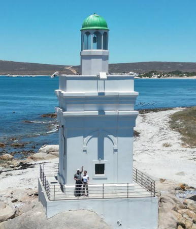
* Milnerton
1960. Active; focal plane 27 m (89 ft); three white flashes, separated by 3.7 s, every 20 s. 21 m (69 ft) round cylindrical concrete tower with a small lantern and gallery, painted white; lantern is red. Google's 2022 street view is at the top of this page, Claußen has good 2008 photos, Trabas has Brotherston's photo, Darren Rudolph has a 2021 closeup photo, and Google has a satellite view. This modern tower stands at the northeastern corner of Table Bay; the view from here, with Table Mountain and Cape Town seen across the bay, is spectacular. The beach in this area is a dangerous lee shore for ships arriving in Cape Town, and there have been dozens of shipwrecks over the years. Located in a parking lot at the foot of Bridge Street on Woodbridge Island in Milnerton, about 15 km (9 mi) around the bay shore from the Cape Town waterfront. Site open, tower closed. . ARLHS SAF-017; Admiralty D5910; NGA 113-25976.
* Robben Island
1865 (Joseph Flack). Active; focal plane 47 m (154 ft); white light, 5 s on, 2 s off; a red sector is shown to the south southeast to warn ships leaving Cape Town away from the island. 18 m (59 ft) round brick tower with lantern and gallery attached to 1-story keeper's house. Tower painted white with a black vertical stripe on the east side; lantern painted red. This is a staffed station. Hansa Photography's photo is at right, Trabas has Brotherston's photo, Manfred Leiter has posted a large closeup photo, Dominic Naidoo has a photo, Dane Paijmans has a good photo, Huelse has a historic postcard view, and Google has a satellite view and a distant street view. Robben Island, 9 km (5.5 mi) north of Cape Town, was the site of a maximum security prison from 1959 until the end of the apartheid government of South Africa; it is best known as the place where Nelson Mandela, the late president of South Africa, was imprisoned from 1964 to 1982. Today the entire island, except for the light station, is a museum and a recognized World Heritage Site. The lighthouse is located at the highest point of the island, near the south end. The island is accessible by passenger ferry from the Cape Town waterfront (reservations recommended). Site open, tower closed. Site manager: Robben Island Museum. . ARLHS SAF-023; Admiralty D5870; NGA 113-25968.


Robben Island Light, Cape Town, February 2020
Instagram photo by Hansa Photography cc

West Coast District Lighthouses
Dassen Island
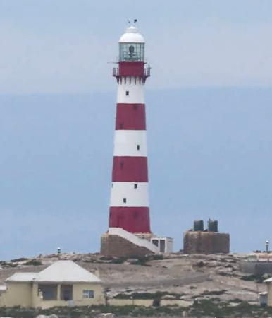
1893. Active; focal plane 47 m (154 ft); two white flashes, separated by 10 s, every 30 s. 28 m (92 ft) round cast iron tower with lantern and gallery, mounted on a 1-story brick base. Lighthouse painted with red and white horizontal bands. Keeper's house and other buildings. Fog horn (5 s blast every 15 s). Johan deLange has a 2022 photo, Blackburn has a small closeup, Trabas has Brotherston's view, John Wilkie has posted a distant view, Huelse has a historic photo, and Google has a satellite view. This is a staffed station. The rocky 220 ha (500 acre) island is a nesting site for endangered African penguins and shelters many other unusual species. Located off the coast south of Yzerfontein and about 55 km (35 mi) north northeast of Table Bay, the island is a major threat to ships arriving in Cape Town. It is named for rock hyraxes (dassies) common on the island. Long closed to the public, it was opened to guided tours in 2002. Accessible only by boat. Site closed except for occasional guided tours; tower closed. Site manager: Cape Nature (Dassen Island Nature Reserve). . ARLHS SAF-042; Admiralty D5860; NGA 113-25956.
Saldanha Bay South Head
1969. Active; focal plane 33 m (108 ft); four white flashes every 30 s. 21 m (69 ft) round cylindrical concrete tower with lantern and gallery. Upper half of the lighthouse painted yellow-brown, lower half white. B. Van Zyl's photo is at right, he has has another good photo, Blackburn has a fine 2009 closeup, and Google has a good satellite view. Access to this lighthouse is through a military installation. Saldanha Bay is a large natural harbor located about 105 km (65 mi) northwest of Cape Town. Located on a headland marking the south side of the entrance to the bay. Site and tower closed. ARLHS SAF-058; Admiralty D5831; NGA 113-25948.
Elandspunt
Date unknown. Active; focal plane 34 m (112 ft); white flash every 5 s. Approx. 16 m (52 ft) square skeletal tower with gallery. No photo available but Bing has a satellite view. Located on a prominent cape on the south side of Saldanha Bay. Site status unknown. Admiralty D5833; NGA 113-25936.
* Lynch Point (Saldanha Bay Entrance) Range Rear
Date unknown. Active; focal plane 46 m (151 ft); white light, 3 s on, 3 s off. 35 m (115 ft) triangular pyramidal skeletal tower carrying a triangular daymark, point down. Trabas has Darlene Chisholm's sunset photo and Google has a good street view and an indistinct satellite view. The front light is on a 12 m (39 ft) skeletal mast. Located at the Laguna Mall shopping center, 800 m (1/2 mi) west of the waterfront in the Skiathos neighborhood of Saldanha Bay. Site open, tower closed. Admiralty D5832.1; NGA 113-25944.
Ore Jetty Range Rear
Date unknown. Active; focal plane 14 m (46 ft); two continuous lights, white above green. 11 m (36 ft) square skeletal tower. A fuzzy sea view is available and Bing has a satellite view. The Saldanha Ore Jetty is 3 km (1.8 mi) long; it accommodates large ore carriers loading iron ore from the Sishen mine 800 km (500 mi) northwest. The front light is on a pole. Located at the end of the jetty. Site and tower closed. Admiralty D5847.1; NGA 113-25920.

South Head Light, Saldanha Bay, August 2014
Google Maps photo by B. Van Zyl
Marcus Island (2?)
Date unknown. Active; focal plane 17 m (56 ft); two white flashes every 10 s. Approx. 14 m (46 ft) concrete post attached to a square 1-story equipment shelter. Entire lighthouse is white. No closeup photo available but Google has a very distant sea view and Bing has a satellite view. NGA lists a framework tower. Marcus Island is joined to the north side of Saldanha Bay by a curved breakwater. Located on the south side of the island, marking the entrance to Saldanha harbor. Site status unknown, probably open. Admiralty D5834; NGA 113-25900.
* Saldanha Bay North Head (Saldanhabaai) (2)
2005 (station established 1939). Active; focal plane 32 m (105 ft); three white flashes every 20 s. 21 m (69 ft) round cylindrical tower with lantern and gallery, painted with black and white spiral bands. Blackburn has an excellent photo, Trabas has Brotherston's photo, Claußen has a distant 2008 photo, B. Van Zyl has a photo, Leon Jacobs has a 2021 photo, and Google has a satellite view. The original lighthouse was an aluminum lattice tower and in Claußen's photo that tower can be seen standing next to the new lighthouse. Nicola Pallitt's December 2004 photo shows the skeletal tower and the new light with its lantern not yet installed. According to Viljoen the light station is on South African Navy property but is accessible from a nature trail. Located on a sharp promontory at the entrance to Saldanha Bay and the port of Saldanha. Site reported open, tower closed. ARLHS SAF-055; Admiralty D5830; NGA 113-25896.
**** Cape Columbine (Paternoster)
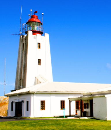
1936 (H.C. Cooper). Active; focal plane 80 m (262 ft); white flash every 15 s. 15 m (49 ft) square Art Deco concrete tower with lantern and gallery. Lighthouse painted white, lantern black, lantern dome red. Several keeper's houses and other station buildings. Fresnel lens in use. Nautophone fog signal (blast every 60 s). This is a staffed station. A 2018 photo is at right, Gordon Greeff has posted a fine photo, Joana doѕ Santoѕ has a 2019 photo, Blackburn has a 2009 photo, and Google has a satellite view. Cape Columbine projects into the Atlantic northwest of Cape Town and has been the scene of numerous shipwrecks. In fact, the cape is named for the barque Columbine, which wrecked here in 1829. The lighthouse is a landfall light for vessels arriving in South Africa from Europe or North America. Transnet has developed the station; there are three cottages for overnight accommodations, a conference facilty, swimming pool, and gift shop. Located on the cape, 3 km (2 mi) west of Paternoster. Site open, tower open to guided tours Monday through Friday. Site manager: Cape Columbine Nature Reserve. . ARLHS SAF-034; Admiralty D5810; NGA 113-25892.

Cape Columbine Light, Paternoster, September 2018
Google Maps photo by Ferreira HR
* Cape St. Martins
1977. Active; focal plane 17 m (56 ft); flash every 10 s, white or red depending on direction. 10 m (33 ft) triangular cylindrical skeletal tower with gallery. The front of the tower carries a large triangular daymark, point down. Blackburn has a closeup photo, B. Van Zyl has a 2020 photo, Liz-Maré Bester has a closeup, and Google has a satellite view. Located on a prominent cape about 7 km (4.5 mi) west of Stompneus Point. Site open, tower closed. Admiralty D5801; NGA 113-25884.
* Stompneus Point (Stompneusbaai, Shelley Point)
1920s. Active; focal plane 11 m (36 ft); white flash every 3 s. 8 m (26 ft) square cylindrical brick tower with lantern. Tower painted white, lantern dome green. A 2022 photo is at right, Trabas has Brotherston's photo, Irmgard Saayman has a 2017 closeup, B. Van Zyl has a photo, Philip Fourie has a 2020 street view, and Google has a satellite view. This unusual lighthouse was built privately (no one seems to know the exact date) and later became official. Located at the northernmost point of the Cape St. Martins peninsula, marking the western entrance to St. Helena Bay, about 20 km (13 mi) northeast of Paternoster. Site open, tower closed. . ARLHS SAF-060; Admiralty D5798; NGA 113-25880.
Berg River Entrance West Breakwater
Date unknown. Active; focal plane 9 m (30 ft); white flash every 2 s. 7 m (23 ft) square cylindrical white concrete tower. A photo is available, John Hall has a distant view, and Google has a satellite view and a distant street view. The Berg River enters St. Helena Bay at the fishing port of Velddrif. Located at the end of the west breakwater; there is a smaller tower on the east breakwater. Site status unknown. Admiralty D5790; NGA 113-25864.
* Lambert's Bay Breakwater
Date unknown. Active; focal plane 13 m (43 ft); white flash every 2 s. 11 m (36 ft) skeletal mast mounted on a square 1-story concrete equipment shelter. Trabas has Brotherston's photo and Google has a satellite view. Located at the end of the main breakwater at Lambert's Bay, a fishing port and beach resort in the Cederberg municipality. Accessible by walking the pier. Site open, tower closed. ARLHS SAF-052; Admiralty D5770; NGA 113-25844.
* Doring Bay (Doringbaai) (2)
1963 (station establishment date unknown). Active; focal plane 36 m (118 ft); two white flashes every 10 s. 24 m (79 ft) concrete tower with lantern and gallery, painted white with a black horizontal band at the top of the tower. Blackburn has an excellent 2009 closeup, B. Van Zyl has a 2018 photo, Maggie Stoudt has a photo, a distant view is available, and Google has a satellite view and a distant street view. The lighthouse was repainted in 2013. The original lighthouse, a skeletal tower, was destroyed by a windstorm in 1991. Located at Doringbaai, a resort and fishing town about 8 km (5 mi) southeast of Strandfontein. Site open, tower closed. ARLHS SAF-044; Admiralty D5734; NGA 113-25840.

Stompneus Point Light, Shelley Point, Decemner 2022
Google Maps photo by Dirk K.

Northern Cape Province Lighthouses

Namakwa District Lighthouses
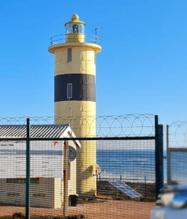
* Groenriviermond
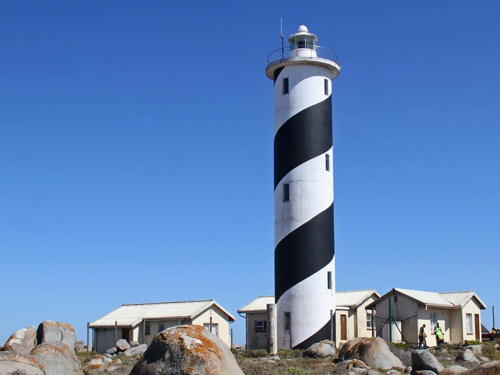
1988. Active; focal plane 27 m (89 ft); white flash every 5 s. 17 m (56 ft) round cylindrical concrete tower, painted yellow with a black horizontal band. A photo is at right, Blackburn has a 2009 photo, Rory Baker has a good 2015 photo, Leon Jacobs has a 2021 photo, and Google has a satellite view. Often described as the "last lighthouse built in South Africa," meaning the last one built on a new location. Located about 2.5 km (1.5 mi) south of the mouth of the Groen River and about 30 km (20 mi) northwest of Strandfontein in the Namaqua National Park. Accessible by 4WD. Site open, tower closed. ARLHS SAF-048; Admiralty D5720; NGA 113-25838.
* Hondeklip Bay (Hondeklipbaai) (2)
2009 (station established 1936). Active; focal plane 29 m (95 ft); three white flashes every 15 s. Approx. 12 m (39 ft) concrete post with lantern and gallery, attached to a 1-story equipment building. Lighthouse is white with a single red horizontal band, lantern painted red. Polla Jansen van Rensburg has a 2018 photo, B. Van Zyl has a photo, Hannes Steyn has a 2020 photo, Blackburn has a 2008 closeup photo taken before the lighthouse was completed, and Google has a satellite view. The original lighthouse, a square steel tower, was removed and replaced by a temporary post light in 2006. "Hondeklip" means "dog rock" in Afrikaans. The village of Hondeklip Bay was formerly a port for the shipment of copper ore but today it is primarily a resort community. Located on a promontory on the north side of Hondeklip Bay. Site open, tower closed. ARLHS SAF-049; Admiralty D5704; NGA 113-25832.
* Port Nolloth (Carl von Schlick) Range Rear
Date unknown (station established 1909). Active; focal plane 17 m (56 ft); four white flashes, in a 3+1 pattern, every 24 s. 11 m (36 ft) triangular cylindrical skeletal tower with gallery. The front of the tower carries a large triangular daymark, point down, painted with black and white horizontal bands. Blackburn has a good photo, Andre Swart has a closeup, and Google has a street view and an indistinct satellite view. The front light is a small beacon only 50 meters (165 ft) west of the rear light. The port of Port Nolloth formerly shipped copper ore and diamonds, but today it is primarily a receational harbor. Located atop a bluff behind the harbor entrance. Site open, tower closed. Admiralty D5660.1; NGA 113-25828.

Groenriviermond Light, Garies, December 2020
Google Maps photo by Hannetjie Ernst

Information available on lost lighthouses:

Notable faux lighthouses:

Adjoining pages: North: Namibia | East: Eastern Cape

Return to the Lighthouse Directory index | Ratings key

Posted June 2, 2005. Checked and revised February 22, 2024. Lighthouses: 43. Site copyright 2024 Russ Rowlett and the University of North Carolina at Chapel Hill.