Lighthouses of South Africa: Eastern Cape

The Republic of South Africa occupies the southern end of the African continent, including the famous capes of Good Hope and Agulhas. During the colonial era Dutch and British colonists struggled for many years to control the country, but by the mid 1800s the entire coastline was under British control. As a result South Africa's lighthouse heritage is British.

The country was formed in 1910 as the Union of South Africa, an autonomous British dominion combining the Cape, Transvaal and Natal colonies and the Orange Free State republic. Full independence was granted in 1931 and the Union became the Republic in 1961.

South Africa is divided into nine provinces and the provinces are divided into districts and municipalities. This page describes lighthouses of the province of Eastern Cape. Eastern Cape occupies the southern coast of the country, facing southeast and south on the Indian Ocean. Its principal ports include East London and Port Elizabeth. There are also pages for the province of KwaZulu-Natal and the provinces of Western Cape and Northern Cape.

Lighthouses in South Africa are operated by the Lighthouses and Navigational Systems division of the Transnet National Ports Authority (TNPA). Some are still staffed. Some of the larger and more accessible light stations have been developed for tourism by the Transnet business office.

Official languages in South Africa include English, Afrikaans, and nine native African languages. In Afrikaans the word for a lighthouse is vuurtoring; eiland is an island, kaap is a cape, punt is a point of land, baai is a bay, and klip is a rock. In the Xhosa language common in the Eastern Cape indlu yokukhanya ("house of light") is a lighthouse.

ARLHS numbers are from the ARLHS World List of Lights. Admiralty numbers are from volume D of the Admiralty List of Lights & Fog Signals. U.S. NGA List numbers are from Publication 112.

General Sources
Charmaine Blackburn - Lighthouses
Photos posted on Flickr.com by Ms. Blackburn. Her blog has additional photos.
Online List of Lights - South Africa
Photos by various photographers posted by Alexander Trabas. Many of the photos for this area are by Don Brotherston, a Johannesburg photographer.
Leuchttürme in Südafrika
Photos posted by Bernd Claußen.
Lighthouses in South Africa
Photos by various photographers available from Wikimedia.
World of Lighthouses - South Africa
Photos by various photographers available from Lightphotos.net.
Afrikanische Leuchttürme auf historischen Postkarten
Postcards from the collection of Klaus Huelse.
GPSNauticalCharts
Navigation chart information for South Africa.
Navionics Charts
Navigation chart information for South Africa.


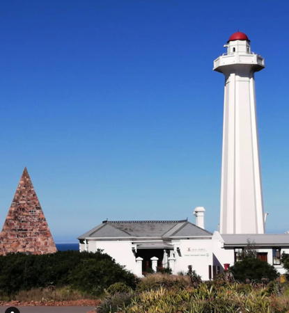
The Hill Lighthouse, Port Elizabeth, MaY 2021
Instagram photo by Beryl Menezes
Wild Coast (O.R. Tambo District) Lighthouses
South Sand Bluff (2)
2006 (station established 1931). Active; focal plane 75 m (246 ft); white flash every 10 s. 10 m (33 ft) round cylindrical white concrete tower with lantern and gallery, adjacent to a 1-story brick equipment building. Lantern is red. Trabas has Brotherston's photo, John Roskilly has a photo, and Google has a satellite view. This lighthouse replaced a skeletal tower. The lantern is a recent addition. Located in a remote area not far south of the KwaZulu Natal border. Probably accessible by 4WD. Site open, tower closed. ARLHS SAF-059; Admiralty D6446; NGA 32052.
* Cape Hermes
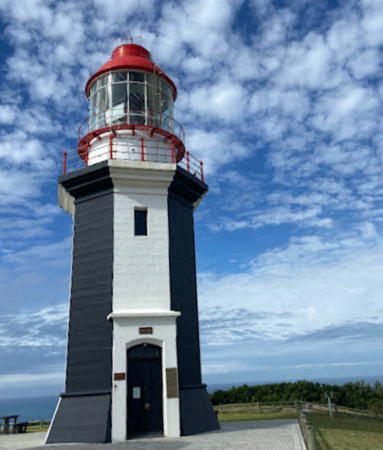
1904. Active; focal plane 55 m (180 ft); white flash every 3 s. 13 m (43 ft) octagonal stone tower with lantern and gallery, painted black with white trim; lantern and gallery painted white. 1-story keeper's house and other station buildings. A 2021 photo is at right, Trabas has Brotherston's closeup, Noel Stapelfeldt has a closeup photo, Charmaine Blackburn has a 2008 photo, a 2022 photo is available, Huelse has a historic postcard view, and Google has a satellite view. This is a staffed light station; when Viljoen visited in 2006 he met keeper Hazel Mjoji, who had served there for 30 years. This lighthouse and the next two are the only major lights on South Africa's Wild Coast, a rugged coastline between East London and the KwaZulu Natal border. Located on a headland just south of Port St. Johns, a town of about 6500 residents 220 km (140 mi) northeast of East London. Site open, tower open by arrangement with the keeper. ARLHS SAF-035; Admiralty D6442; NGA 32056.
M'bashee (M'bashe) Point (2)
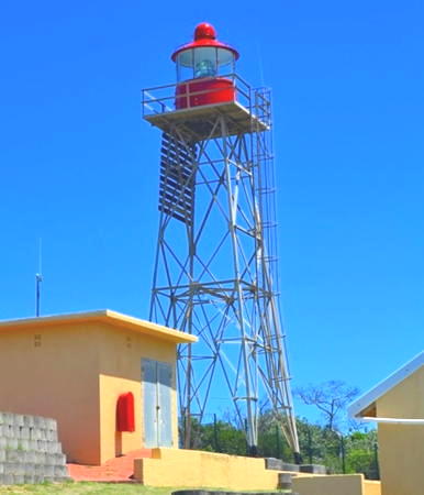
Date unknown (station established 1892). Active; focal plane 46 m (151 ft); three white flashes every 38 s (in an unusual pattern, the flashes are separated by 5 s, 16 s, and 16 s). 14 m (46 ft) square skeletal tower with lantern and gallery. Lighthouse painted white, lantern dome red. An article has a photo and the history of the station, and Google has a satellite view. This is a staffed station; the keeper's houses are 250 m (820 ft) to the north. Viljoen was shown the site of the original lighthouse, but we don't know anything about its appearance. It was demolished in 1944. Located in a remote area on the east side of the mouth of the M'Bashee River. Accessible by 4WD over a gravel (or mud) road about 60 km (38 mi) long. Site open, tower closed. ARLHS SAF-053; Admiralty D6438; NGA 32060.

Cape Morgan Light, Morgan's Bay, December 2021
Instagram photo by Road Trip SA
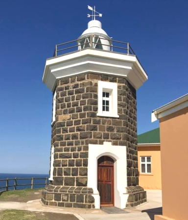
* Cape Morgan
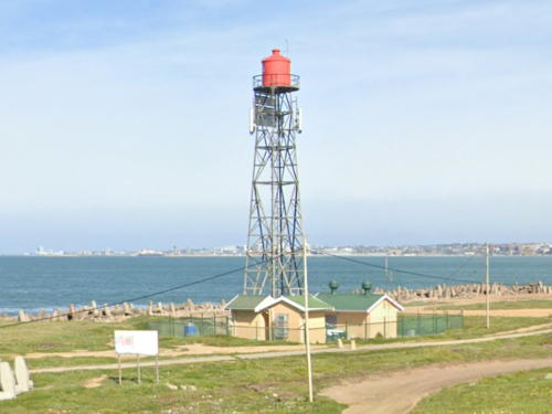
1964. Active; focal plane 60 m (197 ft); two white flashes every 10 s. 12 m (39 ft) square skeletal tower with lantern and gallery. The tower is unpainted metal; lantern painted red. A 2023 photo is at right, a 2017 photo is available, Ken Lewis has a 2021 photo, and Google has a satellite view. Located on a promontory about 5 km (3 mi) east of the resort town of Morgan Bay. Accessible by a paved road. Site open, tower closed. ARLHS SAF-037; Admiralty D6434; NGA 32064.

East London (Amatole District) Lighthouses
East London (eMonti) is a city of about 275,000 residents; the metropolitan area has a population of about 750,000.

*
Nahoon Point
1956. Active; focal plane 68 m (223 ft); white flash every 3 s. Light mounted atop a 2-story concrete building. Building painted white with one red horizontal band. Zandile Ndlangalavu has a closeup 2021 photo and Google has a satellite view. The station is inside the Nahoon Point Nature Reserve. Located on heights above a promontory about 5 km (3 mi) northeast of East London. Accessible by an unpaved and unmarked entrance. Site open, tower closed. ARLHS SAF-054; Admiralty D6432; NGA 32068.
East London East Breakwater (2?)
1950s (station established 1902). Active; focal plane 10 m (33 ft); quick-flashing green light. 8 m (26 ft) round strongly conical white concrete tower. Duncan Boyd has a 2017 photo, Mike Stone has a photo, and Google has a satellite view. A "white iron column" was listed originally for the north side of the harbor entrance. Located at the end of the east (really north) breakwater of East London. Site and tower closed (although this restriction is poorly enforced). Admiralty D6426; NGA 32072.
East London South Breakwater
1950s. Active; focal plane 16 m (52 ft); red flash every 2 s. Approx. 13 m (43 ft) round strongly conical white concrete tower mounted on a large square white concrete base. Fog horn (four blasts: two long, one short, and one long, every 30 s). Jaco Du Plessis has a 2018 photo, the light is seen in the distance in Duncan Boyd's photo of the East Breakwater Light, and Google has a satellite view. Located at the end of the main breakwater of East London. Site and tower closed. Admiralty D6424; NGA 32076.

Cape Morgan Light, Morgan's Bay, Septembaer 2023
Instagram photo by Encounter the Eastern Cape
 
East London South Breakwater Root
Date unknown. Active; focal plane about 10 m (33 ft); quick-flashing white light. Approx. 7 m (23 ft) square concrete tower painted white. Chrizelda Van Staden has a very distant view (light to the left of the boat) and Google has a satellite view. Located near the base of the south breakwater. Site and tower closed. Admiralty D6424.2; NGA 32080.
Castle Point Range Front (2?)
Date unknown (station established 1965). Active; focal plane 21 m (69 ft); continuous red light. Approx. 18 m (59 ft) square pyramidal skeletal tower carrying a white triangular daymark, point up. Matthew Kitchen has a photo, Trabas has a photo, and Google has a satellite view. This light is near the site of the former Castle Point lighthouse (see below under Lost Lighthouses). Located at the end of a quay opposite the East Breakwater Light and 363 m (0.23 mi) east of the rear light. Site and tower closed. Admiralty D6428; NGA 32084.
Castle Point Range Rear (2)
2010-11 (station established 1965). Active; focal plane 60 m (197 ft); white light occulting once every 3 s. 47 m (154 ft) square pyramidal skeletal tower, painted with red and white horizontal bands and carrying a white triangular daymark, point down. Matthew Kitchen has a photo, Trabas has a photo, Susanna de Villiers has a drone view, and Google has a street view and a satellite view. The light was originally on a grain elevator; the elevator was imploded in 2015. Located near the base of the south breakwater. Site and tower closed. Admiralty D6428.1; NGA 32088.
*** Hood Point (East London)
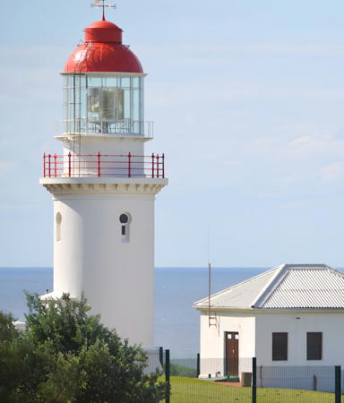
1895. Active; focal plane 55 m (180 ft); four white flashes, separated by 4.2 s, every 40 s; this is a leading light visible only along the approach to East London from the northeast. 14 m (46 ft) round cylindrical brick tower with lantern and gallery, painted white; lantern dome painted red. The original Chance Brothers 1st order Fresnel lens remains in use. 1-story keeper's house and other buildings. This is a staffed station. Andreas Schill's photo is at right, Trabas has Brotherston's closeup, and Google has a street view and a satellite view. Huelse as a historic postcard view showing the tower painted in a black-and-white checkerboard pattern. This is the landfall light for the port of East London. The light station was closed in 2012 for restoration and repair of damage by vandalism; it reopened in 2016. Located adjacent to the West Bank Golf Club on a headland about 5 km (3 mi) south of downtown East London. Site open; visitor center and tower open daily except Fridays year round. . ARLHS SAF-050; Admiralty D6420; NGA 32092.

Hood Point Light, East London, January 2020
Google Maps photo by Andreas Schill

Eastern Cacadu District Lighthouses
**** Great Fish Point (Great Fish River)
1898. Active; focal plane 85 m (279 ft); white flash every 10 s. 9 m (30 ft) octagonal cylindrical concrete tower with lantern and gallery. The vertical faces of the tower are painted alternately black and white; lantern painted white with a red dome. Original 2nd order clamshell Fresnel lens. Moira Bannister's 2023 photo is at right, Trabas has Brotherston's closeup, Anita Cronje has a 2019 photo, Leonora Parker has a 2007 photo, and Google has a satellite view. The lighthouse was built to warn ships away from a series of dangerous reefs offshore. Transnet has developed the site with a visitor center and gift shop, two cottages for overnight accommodations, a swimming pool, and a meeting hall popular for weddings. Located on a headland at the mouth of the Great Fish River, off the R72 highway 25 km (15 mi) northeast of Port Alfred. The entrance is marked on the R72 highway. Site open, tower open to guided tours daily October through April and on weekdays the rest of the year. . ARLHS SAF-046; Admiralty D6416; NGA 32096.
* Kowie River (Port Alfred) Leading
Date unknown. Active; focal plane about 16 m (52 ft); leading light, characteristic unknown. Approx. 12 m (39 ft) square cylindrical skeletal tower. A photo is available and Google has a street view but only a fuzzy satellite view. Located on the south breakwater of the Kowie River entrance at Port Alfred, a town of about 25,000 residents. Accessible by walking the pier. Site open, tower closed. Admiralty D6414.7.
Bird Islands
1852. Active; focal plane 29 m (95 ft); two white flashes every 20 s. 26 m (85 ft) square cylindrical stone tower with lantern and gallery, rising from the center of a 1-story keeper's house. Lighthouse painted red with a white horizontal band at the top of the tower and a large white cross on the front face. Sahr Zebary has a fine 2022 photo, Trabas has an excellent calendar photo, B. Van Zyl has a 2021 photo, Huelse has a historic postcard view, and Google has a satellite view. The Bird Islands were declared a marine protected area in 2004, and there is a proposal to include them in a Greater Addo National Park, an expansion of the existing Addo Elephant National Park. Located on the largest of four small islands in Algoa Bay 62 km (39 mi) east of Port Elizabeth. Accessible only by boat; the island is closed to visitors now but may be opened to guided ecotours in the future. Site and tower closed. ARLHS SAF-002; Admiralty D6412; NGA 32104.

Great Fish Point Light, Port Alfred, April 2023
Google Maps photo by Moira Bannister

Port Elizabeth (Gqeberha, Nelson Mandela Bay Municipality) Lighthouses
Port Elizabeth was founded in 1820 by Sir Rufane Donkin, the colonial governor of the Cape colony, and namd for his late wife. Since 2021 it has been renamed officially as Gqeberha, the Xhosa name for the river that flows through the city. The name Port Elizabeth remains in common use. The city is the seat of the Nelson Mandela Bay Municipality.
Ngqura East Breakwater
2009. Active; focal plane 18 m (59 ft); quick-flashing green light. 11 m (36 ft) round cylindrical concrete tower rising from a square 1-story equipment building and carrying a square platform. No photo available but Google has a satellite view. The Port of Ngqura, opened in 2009, is a containership port at Coega on the northeast side of Port Elizabeth. Located at the end of the main breakwater of the port. Site and tower closed. Admiralty D6411; NGA 32105.
Ngqura Entrance Range Front
2009. Active; focal plane 37 m (121 ft); red light, 3 s on, 1 s off. 18 m (59 ft) square skeletal tower painted with red and white horizontal bands and carrying a slatted daymark colored orange with a white vertical stripe. No photo available but Google has an indistinct satellite view. The rear light is on a similar tower only 7 m (23 ft) tall located much higher on the hillside. Located near the base of the east breakwater. Site and tower closed. Admiralty D6410.6; NGA 32106.
Ngqura Harbour Range Front
2009. Active; focal plane 70 m (230 ft); white light, 2 s on, 1 s off. 51 m (167 ft) triangular skeletal tower painted with red and white horizontal bands and carrying a slatted daymark colored orange with a white vertical stripe. Steffen Neumann's photo is at right and Google has a satellite view. This is the approach range for Ngqura Harbour. Located on the west side of the harbor. Site and tower closed. Admiralty D6410.5; NGA 32106.2.
Ngqura Harbour Range Rear
2009. Active; focal plane 103 m (338 ft); white light, 4 s on, 2 s off. 60 m (197 ft) triangular skeletal tower painted with red and white horizontal bands and carrying a slatted daymark colored orange with a white vertical stripe. No photo available but Google has a satellite view. Located about 1 km (0.6 mi) northwest of the front light, at the rear of the harbor development. Site and tower closed. Admiralty D6410.51; NGA 32106.3.

Ngqura Harbour Range Front Light, Coega, 2015
photo copyright Steffen Neumann, courtesy of Jürgen Klinksiek; used by permission
* Deal
1973. Active; focal plane 27 m (89 ft); white flash every 10 s. 22 m (72 ft) triangular skeletal tower with lantern and gallery. Lantern painted red. Trabas has Brotherston's closeup and Google has a street view (a portion is seen at right) and a satellite view. This is a leading light for ships arriving from the east at Port Elizabeth. Easier to see than to visit, the lighthouse stands on the shore next to the southbound exit ramp from the N2 expressway at the Burman Road interchange on the north side of Port Elizabeth. Site open, tower closed. ARLHS SAF-043; Admiralty D6400; NGA 32108.
* Port Elizabeth Range Front
Date unknown. Active; focal plane 36 m (118 ft); quick-flashing red light. 31 m (102 ft) triangular pyramidal skeletal tower, painted with red and white horizontal bands and carrying a triangular daymark. Trabas has Erich Hartmann's photo and Google has a street view and a satellite view. This is the approach range for Port Elizabeth. Google has a street view of the rear light on a white post. Located on the waterfront near the Albany Street interchange on the M4 expressway. Site open, tower closed. ARLHS SAF-071; Admiralty D6403; NGA 32124.
Port Elizabeth Breakwater
Date unknown. Active; focal plane 16 m (52 ft); two very quick red flashes every 6 s. Approx. 14 m (46 ft) round cylindrical concrete tower with gallery, attached to a 1-story equipment cabinet. Entire lighthouse is white. Trabas has Erich Hartmann's photo, a closeup photo is available, and Google has a satellite view. The lighthouse was repainted and refurbished in 2008. Located at the end of the main breakwater of Port Elizabeth. Site probably closed. ARLHS SAF-056; Admiralty D6404; NGA 32116.

Deal Light, Port Elizabeth, September 2023
Google Maps street view

Port Elizabeth Leading
Date unknown. Active; focal plane 37 m (121 ft); continuous or quick-flashing light, white, red or green depending on direction. 31 m (102 ft) square skeletal tower carrying a triangular daymark. Trabas has Erich Hartmann's photo, Matthew Kitchen has a photo, and Google has a distant street view and a fuzzy satellite view. This directional light guides vessels into the harbor; after following the approach range they must make a sharp turn toward this light. Located on a pier near the base of the breakwater. Site and tower closed. Admiralty D6405; NGA 32120.
*** Port Elizabeth (The Hill, Donkin Reserve)
1861 (rebuilt in 1930). Inactive since 1973 (a decorative light is shone during evening hours). 26 m (86 ft) octagonal tower with lantern, gallery, and four ribs, rising from a 1-story keeper's house. Lighthouse painted white, lantern dome red. Near the lighthouse is a sandstone pyramid built as a memorial to Elizabeth Donkin, the wife of Sir Rufane Donkin, the city's founder; the city was named for her. A photo by Beryl Menezes is at the top of this page, Wikimedia has a 2012 photo, Fran Berbeira has a good photo, Nick Boalch has a photo, and Google has a street view and a satellite view. The original lighthouse had a height of 17 m (55 ft); Klaus Huelse has a postcard showing the tower's early appearance. In or about 1930 the lighthouse was raised to its present height and substantially rebuilt; the buttresses were added at that time, giving the tower an Art Deco design. Huelse also has a postcard view from shortly after this renovation. Built high on a hill behind the harbor, the light was replaced in 1973 by the Deal Light (see above). The keeper's house now houses the city's tourist information center. A September 2009 photo shows the lighthouse being repainted. Located in the Donkin Reserve, a historic park near the center of Port Elizabeth. Site open, tourist information center and tower open daily except Sundays. Owner/site manager: Nelson Mandela Bay Municipality (Donkin Reserve). . ARLHS SAF-013.
Cape Recife North Beacon
Date unknown. Inactive daybeacon. Approx. 15 m (49 ft) square masonry tower painted with black and white horizontal bands. Christoff Vosloo has a photo and Google has a satellite view. The navigational purpose of this beacon is not clear. Located in the surf about 500 m (1/3 mi) north of the Cape Recife Lighthouse. Accessible only by boat but easy to see from the beach. Site open, tower closed.
** Cape Recife
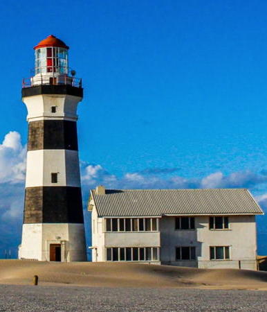
1851. Active; focal plane 28 m (92 ft); continuous white light, intensified by three long (2.8 s) white flashes, separated by 27 s, every 117 s; a red sector is shown over the very dangerous Thunderbolt Reef to the south southeast. 24 m (79 ft) octagonal brick tower with lantern and gallery, attached to 1-story keeper's house. 1st order Fresnel lens in use. Lighthouse painted with black and white horizontal bands; lantern dome painted red. 3-story square cylindrical fog signal tower attached to the other end of the keeper's house. Two additional 2-story keeper's houses. This is a staffed station. A 2024 photo by Nicholas Harris is at right, Trabas has an excellent calendar photo, Cyril Peters has a 2021 photo, Edward Ruthven has a 2022 photo, Raz Barneahas a nice photo, a closeup of the lantern is available, Huelse has a historic postcard view, Bob Stapleton has a street view, and Google has a satellite view. South Africa's third oldest lighthouse guards one of the most dangerous points along the South African coast at the southern entrance to Nelson Mandela Bay (Algoa Bay). The light station is adjacent to the Cape Recife Nature Reserve and is surrounded by a very broad sandy beach. Located off Marine Drive about 20 km (12 mi) southeast of Port Elizabeth. Site open, access to the tower is available (call ahead for a reservation and report to the reception desk of the nearby Pine Lodge Resort). . ARLHS SAF-009; Admiralty D6390; NGA 32144.

Cape Recife Light, Port Elizabeth, February 2024
Instagram photo by Nicholas Harris

Western Cacadu District Lighthouse
**** Cape St. Francis (Seal Point)
1878 (Joseph Flack and W.B. Hays). Active; focal plane 36 m (118 ft); white flash every 5 s. 28 m (92 ft) brick tower with lantern and gallery, rising from a 1-story keeper's house; original 2nd order Fresnel lens in use. Entire lighthouse painted white. Fog horn (Morse code "C," short-long-short-long, every 30 s). This is a staffed station. A 2023 photo is at right, Hannes Steyn has a good photo, Trabas has Brotherston's closeup, Dewald Pretorius has a 2021 photo, Wikimedia has photos, Claußen has a page for the lighthouse, Albert Janse van Rensburg has a street view, and Google has a good satellite view. South Africa's tallest masonry lighthouse still has a resident keeper. A wildlife rehabilitation center operated by SANCCOB (Southern African Foundation for the Conservation of Coastal Birds) is located at the light station. Overnight accommodations are available in the two wings of the lighthouse, and there's a restaurant and café. Located at the end of the R330 highway about 30 km (20 mi) south of Humansdorp. Site open and tower tours are available daily year round. Site manager: Seal Point Lighthouse. ARLHS SAF-039; Admiralty D6386; NGA 32148.

Information available on lost lighthouses:

  • Castle Point (1865-1929), East London. Matthew Kitchen has a painting and a historic photo of the lighthouse, a square tower with lantern and gallery painted with red and white horizontal bands. The lighthouse was deactivated in favor the Hood Point Light in 1895. It was demolished in 1929. The Castle Point Range Lights (see above) are in the same area today.

Notable faux lighthouses:

  •  

Cape St. Francis (Seal Point) Light, Humansdorp, November 2023
Instagram photo by Cape Saint Francis Lighthouse

Adjoining pages: North: KwaZulu-Natal | West: Western Cape and Northern Cape

Return to the Lighthouse Directory index | Ratings key

Posted June 2, 2005. Checked and revised February 14, 2024. Lighthouses: 26. Site copyright 2024 Russ Rowlett and the University of North Carolina at Chapel Hill.