Lighthouses of Italy: Southern Puglia (Apulia)

Most of Italy (officially the Italian Republic, Repubblica Italiana in Italian) occupies a long peninsula in the Mediterranean Sea, with the Adriatic and Ionian Seas on the east and the Ligurian and Tyrrhenian Seas to the west; the country also includes the Mediterranean's two largest islands, Sicily and Sardinia, and many smaller islands. With this geography Italy has a very long coastline reckoned by geographers at about 7600 km (4722 mi). Guarding this coast are many lighthouses; the Directory lists more than 400.

Italy is divided into 20 regions (regioni), many of them well known outside the country in their own right. This page includes the lighthouses of the southern half of the Italian region of Puglia (also known historically as Apulia), including the provinces of Brindisi, Lecce, and Taranto. Puglia includes the Salento peninsula, the high heel of the Italian "boot." The east side of the peninsula faces northeast on the Adriatic Sea and east on the Strait of Otranto, the south end faces the Ionian Sea, and the west coast faces the Gulf of Taranto. The city of Taranto is the most important port of the region, but there are many other ports.

Prior to the unification of Italy in 1861 all of Puglia was part of the Kingdom of Naples until the end of the Napoleonic Wars (1803-1815) when the Kingdom of Naples merged with Sicily to form the Kingdom of the Two Sicilies.

The Italian word for a lighthouse is faro, plural fari. This name is usually reserved for the larger coastal lights; smaller beacons are called fanali. In Italian isola is an island, isolotto is an islet, secca is a shoal, cabo is a cape, punta is a point of land, baia is a bay, stretto is a strait, fiume is a river, and porto is a harbor.

Aids to navigation in Italy are operated and maintained by the Italian Navy's Servizio dei Fari e del Segnalamento Marittimo (Lighthouse and Maritime Signal Service). Lighthouse properties are naval reservations, generally fenced and closed to the public.

ARLHS numbers are from the ARLHS World List of Lights. EF numbers are from the Italian Navy's light list, Elenco Fari. Admiralty numbers are from volume E of the Admiralty List of Lights & Fog Signals. U.S. NGA List numbers are from Publication 113.

General Sources
Online List of Lights - Italy
Photos by various photographers posted by Alexander Trabas. Many of the photos for this area are by Capt. Peter Mosselberger ("Capt. Peter") or by Eckhard Meyer.
Fari e Segnalamenti
Lighthouse information from the Italian Navy's Servizio dei Fari.
Lighthouses in Italy
Photos by various photographers available from Wikimedia.
World of Lighthouses - Italy
Photos by various photographers available from Lightphotos.net.
Lighthouses in Italy
Aerial photos posted by Marinas.com.
Italienische Leuchttürme auf Historischen Postkarten
Historic postcard images posted by Klaus Huelse.
GPSNavigationCharts
Navigation chart information for Puglia.
Navionics Charts
Navigation chart for Puglia.


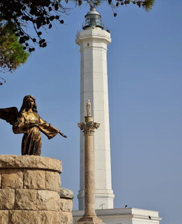
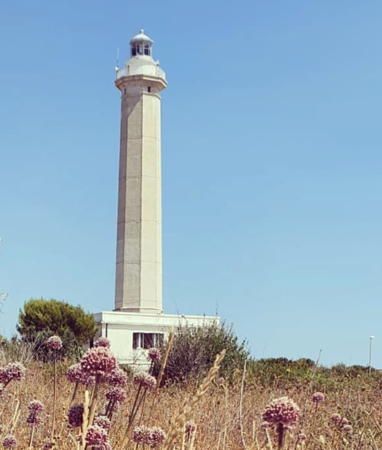
Santa Maria di Leuca Light, Leuca, July 2021
Google Maps photo by Giuseppina D'Anna

Brindisi Province Lighthouses

Torre Canne Lighthouse
* Torre Canne (Punta Torre Canne)
1929. Active; focal plane 35 m (115 ft); two white flashes every 10 s. 32 m (105 ft) octagonal white concrete tower with lantern and gallery, rising from the seaward side of a 1-story keeper's house. Davide Nardelli's photo is at right, Trabas has Caot. Peter's photo, another photo is available, Vito Di Gravina has a 2019 photo, and Google has a street view and a satellite view. Located on a point of land in the town of Torre Canne about 40 km (25 mi) northwest of Brindisi. Site open, tower closed. . ARLHS ITA-150; EF-3688; Admiralty E2222; NGA 10856.

Brindisi Lighthouses
The provincial capital of Brindisi is a city of about 90,000 residents and an important port; it is also the terminal for ferries to Greece and Albania.

*
[Punta Penne (1)]
Date unknown (around 1890?) (station established 1861). This was formerly a 34 m (112 ft) round tower attached to a keeper's house; Huelse has a historic postcard view. The light tower is gone, disappeared around the time of World War I, but the keeper's house remains. Google has a street view and a satellite view. This station should not be confused with the Punta Penna lighthouse in Abruzzo (see Eastern Italy).
* Punta Penne (2)
Date unknown (before 1920) (station established 1861). Inactive since around 1960. 13 m (43 ft) square stone watchtower. A photo is available (note the corner of the original keeper's house at the right edge of the photo), Andrea Casali has a 2021 photo, and Google has a satellite view of the station. We need more information on the history of this station. Located on a promontory about 3 km (2 mi) northwest of the Diga di Punta Riso in Brindisi. Site open, tower closed.
* Brindisi Diga di Punta Riso (North Breakwater) (2)
Date unknown (station established 1893). Active (privately maintained); focal plane 12 m (39 ft); two green flashes every 10 s. 10 m (33 ft) round tapered concrete tower with gallery, painted green. Trabas has a photo by Capt. Romeo Lucero, Alessio Mitrotta has a photo, Massimo Loiacono has a 2022 photo, and Google has a satellite view. Located at the end of the long breakwater on the north side of Brindisi harbor. Accessible by walking the pier, but it is quite a long walk. Site open, tower closed. ARLHS ITA-069; EF-3631; Admiralty E2198; NGA 10822.5.
* Brindisi Diga di Punta Riso (North Breakwater) (1)
1893. Inactive. Approx. 8 m (26 ft) round cylindrical stone tower with gallery, now falling into ruins. The tower was covered with plaster and painted black with a white horizontal band, but the plaster has peeled from much of the tower. Fabio Vitale has a good photo, Zio Danilo Distante has a photo, Paolo Bartone has a closeup street view, and Google has a satellite view. Located near the root of the long breakwater on the north side of Brindisi harbor. Site open, tower closed.

Torre Canne Light, Torre Canne, July 2020
Wikimedia Creative Commons photo by Davide Nardelli
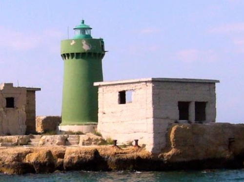
Brindisi Diga di Castello a Mare (North Inner Breakwater)
1911. Active; focal plane 12 m (39 ft); green flash every 3 s. 9 m (30 ft) round concrete tower with lantern and gallery, painted green. Charles Schuurman has a photo (also seen at right), Trabas has Meyer's photo, Michael Flint has a view from the sea, Huelse has a historic postcard view, and Google has a satellite view. Located at the end of the north inner breakwater of Brindisi, directly below the walls of the Castello a Mare. Site and tower closed. EF-3644; Admiralty E2204; NGA 10824.
Brindisi Castello a Mare (Castello Aragonese, Castello Alfonsino) (2, #3)
1984 (station established 1844). Reactivated (inactive from the 1880s to 1934 and again 1984-2004). Lantern mounted on the wall of the castle. From 1984 to 2004 the light was shown from a 12 m (39 ft) square skeletal tower with enclosed upper portion. Trabas has Meyer's photo, Gianluca Novelli has a view from the sea, and Google has a very distant street view and a satellite view. The 1984 tower was removed in 2017 leaving only the older lantern, as seen in Roberto Galasso's November 2017 photo. Dating from the late 1400s the castle is also called the Castello Alfonsino (after Alfonso, the duke of Calabria who completed the first version of the structure in 1492). The fortress has been under restoration as a tourist attraction. Located on an island that is now joined to the mainland by a causeway and serves as the anchor of the north breakwater of Brindisi harbor. Site and tower closed, but there are good views from many locations around the harbor. ARLHS ITA-314; EF-3626; Admiralty E2202; NGA 10823.5.
Canale Pigonati Northeast
1897. Active; focal plane 9 m (30 ft); green light, 1 s on, 1 s off. 6 m (20 ft) post centered on a square 1-story equipment shelter. Lighthouse painted green. Trabas has Meyer's photo and Google has a satellite view. The Canale Pigonati is the narrow entrance to the inner harbor of Brindisi. Located on the north side of the entrance. Site and tower closed. ARLHS ITA-268; EF-3662; Admiralty E2210; NGA 10836.

Diga di Castello a Mare Light, Brindisi, April 2008
Google Maps photo by Charles Schuurman
* Monumento del Marinaio d'Italia
1984 (tower built 1933). Inactive as a navigational aid since 2004, although the tower still carries a flashing red aviation warning light. 53 m (174 ft) square tapered brick tower. No lantern; the light was displayed from an alcove near the top of the tower that also holds a statue of Virgin Mary. Michele Conte has a closeup, Frederick Hernandez has a nice view of the monument, Ilona Van Vlodrop has a 2023 photo, Steffen Reinhardt has a street view and Google has a satellite view. The tower is part of the Monument to the Italian Sailor, built in 1933 during the Mussolini era. Ownership of the monument was transferred to the city in 2014. Located in a park on the north side of the inner harbor of Brindisi. Site open, tower closed. Owner/site manager: Città di Brindisi. . ARLHS ITA-107; ex-Admiralty E2202.
* Canale Pigonati Southeast
1897. Active; focal plane 9 m (30 ft); red light, 1 s on, 1 s off. 6 m (20 ft) post centered on a square 1-story equipment shelter. Lighthouse painted red. Trabas has a closeup photo and Google has a satellite view. Located on the south side of the entrance to the Canale Pigonati. Site open, tower closed. ARLHS ITA-267; EF-3668; Admiralty E2212; NGA 10832.
#Brindisi Diga di Costa Morena (South Inner Breakwater)
Date unknown. Inactive since 2012. Formerly a 7 m (23 ft) round concrete tower with lantern and gallery, painted red. Google's satellite view shows how the breakwater has been replaced by a broad quay. There is an active light on a post (focal plane 7 m (23 ft); continuous red light); Trabas has Capt. Peter's photo. Formerly located at the end of the south inner breakwater of Brindisi, directly opposite the Castello a Mare. Site closed. ARLHS ITA-188. Active light: EF-3650; Admiralty E2206.
* Le Pedagne (Isolotto Traversa)
Date unknown (station established 1861). Active; focal plane 21 m (69 ft); two red flashes every 6 s. 18.5 m (71 ft) round masonry tower with lantern and gallery, centered on a circular 1-story keeper's house. Lighthouse painted white; lantern dome is gray metallic. A photo is at right, Trabas has a photo by Capt. Peter, Charles Schuurman has a photo, a 2020 closeup is available, Panagiotis Pazoulis has a view from the sea, and Google has a satellite view. Located on a reef in the middle of the entrance to Brindisi harbor. Accessible only by boat. Site and tower closed. ARLHS ITA-175 (=218); EF-3632; Admiralty E2196; NGA 10816.
* Torre Mattarelle
Date unknown (1940s). Inactive since around 1960 (?). 15 m (49 ft) ruined square stone watchtower. A photo is available and Google has a satellite view. The property was reported for sale in 2008. Located on a promontory about 8 km (5 mi) southeast of Brindisi. Site status unknown, probably open.
Le Pedagne Light
Le Pedagne Light, Brindisi, August 2012
ex-Panoramio photo copyright 52picchio; used by permission

Lecce Province Lighthouses

Lecce Province is the tip of the heel in the Italian boot, incorporating the lower Salento Peninsula and projecting southeastward into the Ionian Sea. Its major ports are Otranto on the east side of the peninsula and Gallipoli on the west side.

Eastern Lecce Province (Otranto Area) Lighthouses
* San Cataldo di Lecce (2)
1897 (station established 1866). Active; focal plane 25 m (82 ft); white light, 2 s on, 3 s off. 23.5 m (77 ft) octagonal masonry tower with lantern and gallery, attached to a 1-story keeper's house. Lighthouse painted white; lantern dome is gray metallic. Trabas has a photo by Meyer, Antonio D'ostuni has a 2024 photo, a nice view is available, Marinas.com has aerial photos, and Google has a street view and a satellite view. This light is easily confused with the taller Punta San Cataldo Light in Bari (see the Northern Puglia page). There have been some alterations in this lighthouse, as older photos show it with a second gallery. Located just off a popular beach at Punta San Cataldo di Lecce, about 12 km (7.5 mi) east of Lecce. Site open, tower closed. . ARLHS ITA-142; EF-3612; Admiralty E2192; NGA 10808.
* Torre Sant'Andrea (Sant'Andrea di Missipezza)
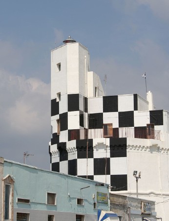
1932. Active; focal plane 24 m (79 ft); two flashes every 7 s, white or red depending on direction. 16 m (52 ft) lantern mounted atop a square masonry building. The seaward side of the building is painted in a bold black and white checkerboard pattern; the lantern is gray metallic. Trabas has a closeup photo by Capt. Peter, Antonio D'ostuni has a photo, and Google has a street view and a satellite view. The lighthouse warns ships away from shoals nearby. Located about 2.5 km (1.5 mi) south of Torre dell'Orso. Site open, tower closed. ARLHS ITA-170; EF-3608; Admiralty E2188; NGA 10800.
* Otranto (Punta Cràulo, La Punta) (2)
Date unknown (station established 1903). Active; focal plane 12 m (39 ft); three flashes every 10 s, white or red depending on direction. 9 m (30 ft) post light with gallery centered on a square 1-story concrete equipment room. Entire lighthouse painted white. Trabas has a good photo by Capt. Peter, Paolo Latronico has a photo, Carlo Ceccarelli has a 2022 closeup, and Google has a street view and a satellite view. The original light was described as a 6 m (20 ft) "iron support." Located at the end of a short breakwater at the north side of the entrance to the harbor of Otranto. Accessible by walking the pier. Site open, tower closed. EF-3600; Admiralty E2182; NGA 10792.
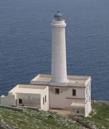
*** Capo d'Otranto (Punta Palascia) (1)
1867. Reactivated (inactive 1970s-2009); focal plane 60 m (197 ft); white flash every 5 s. 32 m (105 ft) round stone tower with lantern and gallery, rising from a 2-story keeper's house. The entire lighthouse is white; lantern roof is gray. 4th (?) order Fresnel lens. Trabas has Egidio Ferrighi's photo seen at right, Donato Surano has a good photo, Angelo Palma has a 2021 photo, and Google has a street view and a satellite view. This is Italy's easternmost lighthouse, marking the narrowest point of the Strait of Otranto, the mouth of the Adriatic Sea. Ham radio operator IK7JWX has a photo of the lighthouse that shows the sun rising over the Albanian coast on the other side of the strait. The station was abandoned and deteriorating for more than three decades before being restored and reactivated in 2009. The lighthouse is now part of the Observatory of Mediterranean Ecology and Ecosystem Health, a center of the University of Salento. Located on the point of the cape, about 5 km (3 mi) southeast of Otranto. Site open, tower open daily during August. Owner/site manager: Città di Otranto. . ARLHS ITA-137; EF-3596; Admiralty E2178; NGA 10788.
* Capo d'Otranto (La Palascia) (2)
Date unknown (1970s). Inactive since 2009. 5 m (17 ft) square concrete structure formerly carrying a lantern. Antonio Renda has a street view and Google has a satellite view. This light, which replaced the light of the historic lighthouse for more than 30 years, was 25 m (82 ft) higher than the old one on the steep slope of the cape. Site and tower closed but the building can be seen from outside the fence. ARLHS ITA-315.

Capo d'Otranto Light, Otranto, May 2010
photo copyright Egidio Ferrighi; used by permission
 
* Capo Santa Maria di Leuca
1866. Active; focal plane 102 m (335 ft); three white flashes every 15 s; also a red light, occulting once every 4 s, is shown over shoals to the east. 48 m (158 ft) octagonal brick tower with lantern and gallery, rising from a 2-story keeper's house. The bricks of the lighthouse are covered with a white plaster. Giuseppina D'Anna has a 2021 photo also seen at the top of this page, Trabas has another good photo by Capt. Peter, Wikimedia has many photos, Marinas.com has aerial photos, and Google has a street view and a satellite view. The original first order lantern was replaced in 1954. Capo Santa Maria di Leuca is the tip of the Salento peninsula, so this historic lighthouse marks the western entrance to the Strait of Otranto and the Adriatic Sea. Located at the tip of the cape, at the end of the Via Francesco Pireca in Leuca. Site open, tower closed. . ARLHS ITA-039; EF-3590; Admiralty E2176; NGA 10780.
* Santa Maria di Leuca Mole (Molo Sopraflutto)
Date unknown. Active (?) (privately maintained); focal plane 9 m (30 ft); green flash every 5 s. 6 m (20 ft) post atop a round 1-story concrete equipment shelter. Trabas has Capt. Peter's photo and Google has a satellite view. Needed repair in 2020: Google's May 2020 sea view shows the post fallen over. Located at the end of the outer breakwater of the marina just west of the historic lighthouse. Accessible by walking the pier. Site open, tower closed. EF-3591; Admiralty E2176.5.

Western Lecce Province (Gallipoli Area) Lighthouses
* Torre San Giovanni di Ugento
Date unknown. Active; focal plane 23 m (75 ft); white or red light, depending on direction, 2 s on, 2 s off. Lantern mounted atop a late 16th century fortified watch tower. The front of the tower is painted in a bold black and white checkerboard pattern; the lantern is gray metallic. Federico Lucchini's photo is at right, the Navy has a page for the lighthouse, Trabas has an excellent photo by Klaus Potschien, Stefano Tolari has a 2021 photo, and Google has a street view and a satellite view. The tower, built by Carlos V of Spain, is one of a number of towers built in the late 1500s to guard against attacks by the Saracens. Located in the village of Torre San Giovanni, about 6 km (3.5 mi) southwest of Ugento. Site open, tower closed. ARLHS ITA-171; EF-3584; Admiralty E2174; NGA 10776.

Torre San Giovanni Light, Ugento, April 2006
Flickr Creative Commons photo by Federico Lucchini
Isola Sant'Andrea
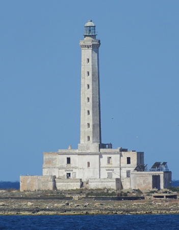
1866. Active; focal plane 45 m (148 ft); two white flashes every 10 s. 43 m (141 ft) octagonal concrete tower with lantern and gallery, rising from a 2-story keeper's house. The entire lighthouse is white; lantern is gray metallic. Trabas has a good photo by Capt. Peter (also seen at right), Leonardo Bray has a 2007 photo, Marinas.com has aerial photos, and Google has a good satellite view. The Isola Sant'Andrea is a flat, sandy island about 2.5 km (1.5 mi) off the waterfront of Gallipoli. Gabriele De Vittorio's 2019 photo shows the lighthouse under restoration. Located on the southwestern edge of the island. Accessible only by boat. Site open, tower closed. . ARLHS-084; EF-3562; Admiralty E2168; NGA 10760.
* Gallipoli Molo di Tramontana
Date unknown (station established 1914). Active; focal plane 10 m (33 ft); green light, 2 s on, 3 s off. 7 m (23 ft) round cylindrical concrete tower with lantern and gallery, mounted on a square stone base. Entire lighthouse painted green. Trabas has Capt. Peter's closeup photo and Google has a satellite view. Located at the end of the breakwater mole of Gallipoli. Accessible by walking the mole. Site open, tower closed. EF-3574; Admiralty E2172; NGA 10764.
* Gallipoli Molo di Sottoflutto
Date unknown. Active; focal plane 10 m (33 ft); red light, 2 s on, 3 s off. 9 m (30 ft) round cylindrical concrete tower with lantern and gallery. Entire lighthouse painted red. Trabas has Meyer's closeup photo and Google has a satellite view and a distant street view. Located at the end of the short inner mole of Gallipoli. Accessible by walking the mole. Site open, tower closed. EF-3574.3; Admiralty E2172.2; NGA 10765.
* Porto Cesareo Anteriore
Date unknown (station established 1914). Active (privately maintained?); focal plane 13 m (43 ft); white light, 1 s on, 1 s off. 12 m (39 ft) square pyramidal skeletal tower mounted on a 2-story square building. The building is covered with tiles colored to display a black and white checkerboard pattern on the side facing the range. Trabas has a photo and Google has a street view and a satellite view. The Navy's web site does not include these range lights. Located at the foot of the Via Giuseppe Zuccaro on the waterfront in Porto Cesareo. Site open, tower closed. ARLHS-237; EF-3554; Admiralty E2164; NGA 10752.
* Porto Cesareo Posteriore
Date unknown (station established 1914). Active (privately maintained?); focal plane 27 m (89 ft); white light, 2 s on, 1 s off. 15 m (49 ft) square cylindrical tower with a round lantern, gallery, and watch room. The building is covered with tiles colored to display a black and white checkerboard pattern on the side facing the range; lantern and watch room painted white. Trabas has a photo by Capt. Peter, Marinas.com has aerial photos, and Google has a street view and a satellite view. Located on the Via Giuseppe Garibaldi near Via 70 in Porto Cesareo, 765 m (1/2 mi) north northeast of the front light. Site open, tower closed. ARLHS-238; EF-3554.1; Admiralty E2164.1; NGA 10756.

Isola Sant'Andrea Light, Gallipoli
photo copyright Capt. Peter Mosselberger; used by permission

Taranto Province Lighthouses

Torre dell'Ovo Lighthouse
* Torre dell'Ovo
1919. Inactive since around 1960. 17 m (56 ft) fortified watch tower. Lantern removed. Anna Francesca Schifa has a 2017 closeup photo and Google has a street view and a satellite view. This is an Aragonese fortified tower built about 1550. Located on a promontory beside the coastal highway (SP122) about 2.5 km (1.5 mi) southeast of Librari and 32 km (20 mi) southeast of Taranto. Site open. ARLHS ITA-319.

Taranto Harbor Lighthouses
Taranto is a major commercial port and also the traditional home port of the Italian Navy. The city's great elliptical harbor, called the Mar Grande, is enclosed by a long north breakwater and a much shorter south breakwater. The north breakwater is interrupted by several islands, the Isole Cheradi, and ends with a short section projecting southeastward from the Isolotto San Paolo.
* Capo San Vito
Date unknown (station established 1869). Active; focal plane 46 m (151 ft); three white flashes every 15 s. 43 m (141 ft) octagonal concrete tower with lantern and gallery, attached to a 2-story keeper's house. The tower is unpainted white concrete. Fede Dep's 2021 photo is at right, Trabas has an excellent photo, Carmelo Tommaso Russo has a 2022 photo, another photo is available, and Google has a street view and a satellite view. Emanuele Punzo has a 2021 photo of the light in action and floodlit in the colors of the Italian flag. Note: there is another Capo San Vito lighthouse, more properly known as San Vito lo Capo, in Sicily. Capo San Vito encloses the south side of the Mar Grande, Taranto's harbor. Located on the point of the cape at the end of the Via del Faro. Site open, tower closed. . ARLHS ITA-040; EF-3432; Admiralty E2132; NGA 10640.
Diga di San Vito
Date unknown. Active; focal plane 19 m (62 ft); two green flashes every 7 s. 19 m (59 ft) tapered square steel skeletal tower with gallery, painted green. Trabas has a photo by Capt. Peter, Luigi D'Ippolito has a photo, and Google has a satellite view. Located at the end of the south breakwater of Taranto. Accessible only by boat, as the breakwater is awash. Site and tower closed. ARLHS ITA-200; EF-3442; Admiralty E2134; NGA 10644.
* Mar Grande Posteriore (Casa Gigante)
Date unknown. Active; focal plane 21 m (69 ft); white light, 1.5 s on, 1.5 s off, visible only close to the range line. 20 m (66 ft) square concrete block tower, painted with black and white vertical stripes. Trabas has a photo, Valeria D'ippolito has a view from the beach, and Google has a street view and a satellite view. This range guides ships outbound from Taranto across the Mar Grande. Located on the Viale del Tramanto at the Via Meda on the waterfront on the north side of Capo San Vito. Site open, tower closed. ARLHS ITA-275; EF-3450.1; Admiralty E2150.1; NGA 10684.
Mar Grande Anteriore (Secca della Tarantola) (2)
Date unknown (station established 1887). Active; focal plane 12.5 m (41 ft); flash every 3 s, white on the range line and green otherwise. 11 m (36 ft) round concrete tower with lantern and gallery, painted green. Trabas has a photo by Capt. Peter, Mario de Siati has a photo, and Google has a satellite view. Located on a small artificial island off the southeast side of the Mar Grande. Accessible only by boat. Site and tower closed. ARLHS ITA-316; Admiralty E2150; EF-3450; NGA 10680.

San Vito Light, Taranto, July 2021
Instagram photo by Fede Dep
* Mare Piccolo Posteriore
Date unknown. Active; focal plane 11 m (36 ft); quick-flashing red light. 10 m (33 ft) square concrete tower with gallery, painted with black and white vertical stripes. Trabas has Capt. Peter's closeup photo, Antonio Caldaralo has a 2021 closeup, and Google has a street view and a satellite view. The front light is on a post offshore. The Mare Piccolo is an inner harbor of Taranto, connected to the Mar Grande by a narrow inlet. Located on the Via della Pineta on the north shore of the Mare Piccolo northeast of Taranto. Site open, tower closed. EF-3508.1; Admiralty E2152.1; NGA 10689.
* Taranto Porto Mercantile East Mole (2?)
Date unknown. Active (privately maintained?); focal plane 12 m (39 ft); green flash every 5 s. 10 m (33 ft) round "bottle" light mounted on a round concrete tower with gallery. Lighthouse painted green. Trabas has a photo by Capt. Peter, Antonio Caldaralo has a 2020 view from the sea, and Google has a satellite view. This light marks the east side of the entrance to a small boat harbor on the Mar Grande. The ruined stone wall on one side of the tower is probably part of the base of an earlier light. Located at the end of a short pier on the Taranto waterfront. Accessible by walking the pier. Site open, tower closed. Admiralty E2146; NGA 10704.
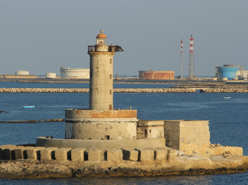
Isolotto San Paolo (2)
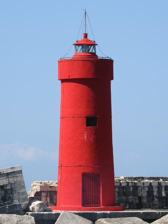
Date unknown (station established 1867). Active (?); focal plane 12 m (39 ft); two red flashes every 7 s. 11 m (36 ft) round cylindrical tower with gallery and a small lantern, painted red. Trabas has Capt. Peter's photo (also seen at right), a distant photo is also available, and Google has a satellite view. In an older photo (no longer available) the red paint is wearing off, revealing an older daymark of red and white horizontal bands. The original lighthouse was atop the east end of the fort on the islet of San Paolo; it had a focal plane of 24 m (79 ft) and served as the landfall light for Taranto. Located at the south end of the breakwater extending from San Paolo Island. Accessible only by boat. Site and tower closed. ARLHS ITA-214; EF-3440; Admiralty E2138; NGA 10648.

Information available on lost lighthouses:


Isolotto San Paolo Light, Taranto
photo copyright Capt. Peter Mosselberger; used by permission

Notable faux lighthouses:

Adjoining pages: North: Northern Puglia | East: Albania | West: Calabria and Basilicata

Return to the Lighthouse Directory index | Ratings key

Posted August 10, 2006. Checked and revised January 23, 2024. Lighthouses: 33. Site copyright 2024 Russ Rowlett and the University of North Carolina at Chapel Hill.