Lighthouses of China: Shànghǎi

The People's Republic of China (中华, Zhōnghuá in Chinese) has a lengthy coastline, many large harbors, and a large number of lighthouses. The country is divided into 23 provinces and 11 other province-level regions of various special types. The province of Jiāngsū (previously spelled Kiangsu) extends southward from the base of the Shāndōng Peninsula to the mouth of the Yangtze River (called Cháng Jiāng in China). The great port of Shànghǎi, now the center of one of the world's largest metropolitan areas, was built on the Huángpǔ River, an artificially dredged estuary on the south side of the Yangtze just above the mouth. Metropolitan Shànghǎi has been separated from Jiāngsū as a provincial-level metropolitan region, Shànghǎi Shì.

As the Yangtze approaches Shànghǎi it divides into two main branches, the Běigǎng Shuǐdào (North Harbor Branch) and the Nángang Shuǐdào (South Harbor Branch). The Huángpǔ joins the South Harbor Branch. Below the Huángpǔ the South Harbor Branch also divides into two channels, the Běicáo (North Channel) and Náncáo (South Branch), separated by a broad area of shoals and mudflats. Both the Běicáo and the Náncáo are improved for entrance to the river by large ships.

There are many languages and dialects spoken in China, but Standard Chinese, often called Mandarin, is official. The pīnyīn system for transliterating Standard Chinese into Latin characters is now the international standard but some locations continue to be known also under the spellings of older transliteration systems. The Chinese word for a lighthouse is dēngtǎ (灯塔). In Standard Chinese jiāo (formerly chiao) is a reef or rock, jiǎo is a cape or headland, dǎo (tao) is an island; (tsu) or tuózi ("lump") is a small island, hǎi is a sea, wān is a bay, hǎixiá is a strait, or jiāng is a river, hékǒu ("river mouth") is an estuary, and gǎng (kang) is a harbor.

Lighthouses in China are maintained by the PRC Maritime Safety Administration. The administration is organized in four regional administrations; Shànghǎi lighthouses naturally fall under the Shànghǎi MSA.

ARLHS numbers are from the ARLHS World List of Lights. CN numbers are Chinese light list numbers. Admiralty numbers are from volume P of the Admiralty List of Lights & Fog Signals. U.S. NGA List numbers are from Publication 112.

General Sources
Online List of Lights - China
Photos by various photographers posted by Alexander Trabas.
Lighthouses in Shanghai
Photos by various photographers available from Wikimedia.
World of Lighthouses - China
Photos by various photographers available from Lightphotos.net.
Chinese English Pinyin Dictionary
A useful tool for juggling the representations of Chinese names.
Leuchttürme Chinas auf historischen Postkarten
Historic postcard images posted by Klaus Huelse.
Navionics Charts
Navigation chart for the Yangtze entrance and Shànghǎi.
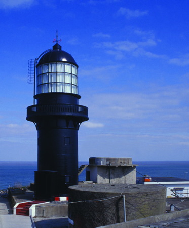

Shéshān Light, East China Sea, Shànghǎi, March 2014
PRC Maritime Safety Administration Dōnghǎi Office photo
Shànghǎi Approach Lighthouses
Shéshān (Shaweishan)
1871. Active; focal plane 70 m (230 ft); white flash every 6 s. 17 m (56 ft) round cast iron tower with lantern and gallery, painted black. This is the traditional landfall light for Shànghǎi. An MSA photo is at the top of this page, a closeup is available, and Bing has a satellite view. This is the original lighthouse, prefabricated in Britain for the Customs Marine Department. It served as a landfall light for the Yangtze. The tower was restored in 1986. Located atop a small island about 35 km (22 mi) east of Chóngmíngdǎo and northeast of the mouth of the North Harbor Branch. Accessible only by boat. Site and tower closed (naval installation). ARLHS PRC-057; CN-2076; Admiralty P3762; NGA 18780.
Jīgǔjiāo (4)
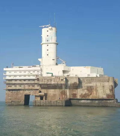
2004 (station established 1986). Active; focal plane 52 m (171 ft); white flash every 5 s. 52 m (171 ft) elliptical cylindrical concrete tower mounted atop a 7-story concrete building, all standing on a large concrete pier. Wikimedia has the good 2016 photo seen at right, a 2021 article has a photo and reports on an MSA project to upgrade the light, and the light station is just barely visible in Google's distant satellite view. The lighthouse stands atop a fort built on an artificial island in 1971 but decommissioned in 1980. Since 2004 it has been a staffed radar and vessel traffic control station. The 1996 lighthouse was a 9 m (30 ft) round fiberglass tower, painted with red and white horizontal bands, mounted atop the concrete building. Located on Jīgǔjiāo (Chicken Bone Reef) about 30 km (19 mi) southeast of the Shéshān lighthouse and 15 km (9 mi) east of the Běicáo (North Channel) entrance. Accessible only by boat. Site and tower closed. CN-2098; Admiralty P3753; NGA 18784.

Běicáo (North Channel) Entrance Lights
Lightship Chángjiāng Kǒu (Yangtze Delta)
Date unknown. Active; focal plane 10.5 m (34 ft); white flash every 6 s. 22 m (72 ft) steel lightship, painted red. Fog bell. There are two buoyed entrance channels for the Yangtze, one from the east and one from the south. This ship marks the start of the buoyed Běicáo (North Channel) entrance. No photo available and the ship is not seen in Google's satellite view. Located about 42 km (26 mi) southeast of the Shéshān lighthouse. CN-2099; Admiralty P3752; NGA 18792.

Jīgǔjiāo Light, East China Sea, Shànghǎi, December 2016
Wikimedia Creative Commons photo by Fayhoo
Niúpíjiāo (Niúpí Jiāo)
Date unknown. Active; focal plane 12 m (39 ft); six quick white flashes followed by one long white flash every 10 s. 12 m (39 ft) round cylindrical tower. Upper half of the tower painted yellow and the lower half black. The light is not shown in Google's satellite view. This is a tide gauging station. Located on a shoal on the north side of the Běicáo entrance channel for the Yangtze. Accessible only by boat. Site and tower closed. CN-2102; Admiralty P3754.2; NGA 18808.
Běicáozhōng
Date unknown. Active; focal plane 12 m (39 ft); three long white flashes every 12 s. 12 m (39 ft) tower painted yellow. No photo available but Google has a satellite view. This is another tide guaging tower. This light stands on the north side of the Zhōngshā (Middle Sand), the large area of shoals and sandflats separating the Běicáo and Náncáo entrances. Located on the south side of the Běicáo entrance to the Yangtze. Accessible only by boat. Site and tower closed. CN-2120; Admiralty P3754.7; NGA 18828.

Náncáo (South Channel) Entrance Lights
Lightship Náncáo (Southern Channel)
Date unknown. Active; focal plane 10.5 m (34 ft); three white flashes every 15 s. 22 m (72 ft) steel lightship, painted red. Fog bell. A photo is at right and the ship is visible faintly in Google's satellite view. This ship marks the start of the buoyed Náncáo (South Channel) entrance. The ship was restored in 2020 after being damaged in a collision with another ship. Located about 12.5 km (7.8 mi) due south of the Chángjiāng Kǒu lightship. CN-2133; Admiralty P3751; NGA 18794.

Lightship Náncáo, Shànghǎi, March 2020
MSA photo previously posted by NetEase
Lightship Jiǔduàn (Section Nine)
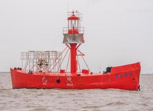
Date unknown. Active; focal plane 10 m (33 ft); two white flashes every 10 s. 23 m (75 ft) steel lightship, painted red. A photo is available and Bing has a satellite view. Historic photos of the original (1870) lightship are available and a fog bell from that ship is displayed in the Customs Museum in Taipei, Taiwan. This ship marks the merger of the southern entrance channel for the Yangtze with an approach parallel to the coast from the south. The ship was repaired after being damaged in a collision in 2020. Located about 10 km (6 mi) offshore and 20 km (13 mi) southeast of the Shànghǎi entrance. CN-2141; Admiralty P3768; NGA 18824.
Zhōng Jùn (2)
1994 (station establishment date unknown). Active; focal plane 9 m (30 ft); three long yellow flashes every 12 s. 9 m (30 ft) rectangular skeletal tower, mounted on a concrete pier and carrying an enclosed lantern-like structure that houses tide gauging equipment. Entire station painted bright yellow. No photo available but Google has a satellite view. Located on a shoal on the south side of the Náncáo entrance to the Yangtze. Located about 5 km (3 mi) offshore and 16 km (10 mi) southeast of the Shànghǎi entrance. Accessible only by boat. Site and tower closed. CN-2165; Admiralty P3767; NGA 18816.

Lower Nángang Shuǐdào (South Harbor Branch) Lights
Héngshā (Héngshādǎo, House Island)
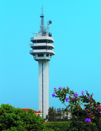
2001. Active; focal plane 57 m (187 ft); white flash every 8 s. 56 m (184 ft) square cylindrical white concrete tower supporting a 3-story harbor control center. An MSA photo is at right, Jayson Hong has a distant view, and Google has a satellite view. This light stands on the north side of the Běicáo (North Channel) entrance to the Yangtze near the point where it joins the Náncáo (South Channel). Located at the southeastern tip of Héngshādǎo, an island of the Yangtze River Delta. CN-2130; Admiralty P3754.69; NGA 18829.
North Training Wall No. 1 (2?)
Date unknown. Active; focal plane about 12 m (39 ft); yellow flash every 6 s. Approx. 12 m (39 ft) tower. No photo available but the tower is seen in Google's satellite view. NGA lists a smaller light. Located between the Běicáo and Náncáo entrance channels about 3 km (2 mi) southwest of the Héngshā lighthouse. Accessible only by boat. Site and tower closed. CN-2119.08; Admiralty P3754.64; NGA 18826.1.
Lightship Yuányuánshā
Date unknown. Active; focal plane 15 m (49 ft); white flash every 6 s. 15 m (49 ft) square skeletal tower with gallery, mounted on a steel lightship. Fog horn. A photo is available and Google has a satellite view. The light marks the point of merger of the Běicáo and Náncáo entrances to the Yangtze. Located in the mouth of the Yangtze about 8 km (5 mi) west of the Héngshā lighthouse. Accessible only by boat. Site open, vessel closed. CN-2157; Admiralty P3770.5; NGA 18834.

Hengsha Light
Héngshā Light, Yangtze River, Shànghǎi
PRC Maritime Safety Administration Dōnghǎi office photo


Bǎoshān Area Lighthouses
Bǎoshān is a harbor district on the south side of the South Harbor Branch of the Yangtze just upstream from the Huángpǔ River entrance.

Xīnliúhéshā No. 1
Date unknown. Active; focal plane about 12 m (39 ft); green light, pattern unknown. Approx. 12 m (39 ft) round concrete tower. No photo available but Google has a satellite view. Located on the east end of a frequently-submerged gravel training wall that restrains a shoal area in the Yangtze opposite Bǎoshān (this is the first of seven similar lights along the training wall). Accessible only by boat. Site open, tower closed. CN-2098.109; Admiralty P3792.1.
Bǎoshān No. 1 Breakwater (2)
Date unknown. Active; focal plane unknown; yellow flash every 2 s. Approx. 15 m (49 ft) round barbell-shaped fiberglass tower, colored with black and white horizontal bands. Trabas has Tom Chisholm's photo, a distant 2022 street view is available, and Google has a satellite view. This light is very similar to the Bǎoshān Pierhead Light (next entry). Located at the end of the long main breakwater at Bǎoshān. Site and tower closed. CN-2215; Admiralty P3790; NGA 18860.
Bǎoshān Pierhead (2)
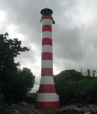
Date unknown. Active; focal plane 15 m (49 ft); red light, 2 s on, 2 s off. 10 m (33 ft) round barbell-shaped fiberglass tower, colored with red and white horizontal bands. James Smith's photo is at right and Google has a satellite view. Located on a short pier on the south side of the entrance to Bǎoshān harbor. Site and tower closed. Admiralty P3790.1.
Baoshan Breakwater No. 1 Light
Bǎoshān Pierhead Light, Yangtze River, Shànghǎi, November 2012
photo copyright James Smith; used by permission

Huángpǔ River (Downtown Shànghǎi) Lighthouses
Wúsōngkǒu (Hetang) (5?)
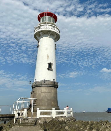
1999 (station established 1865). Active; focal plane 17 m (56 ft); white flash every 5 s. 20 m (66 ft) round cast iron tower with lantern and gallery, mounted on a round stone base. Lighthouse painted white, lantern dome red. A 2023 photo is at right, Jens Schott Knudsen has a 2009 photo, Alex Vickery has a closeup photo, Trabas has a photo, a 2011 photo is available, Wikimedia has a photo of the light in action, and Google has a satellite view. We need more detailed information on the history of this historic light station. Chinese Wikipedia has an article giving 1872 as the date of establishment. The 1872 lighthouse was a 17 m (56 ft) square brick tower on the west side of the mouth of the river. In 1928 the light was moved to the end of the jetty; the light there was replaced in 1988 by a plain round tower painted with red and white bands. Wúsōng is an older name for the Huángpǔ River; it is used now mostly for the lower course of the river. Located at the entrance to the Huángpǔ River, standing at the end of a long, curving breakwater that diverts the Yangtze's sediment away from the Huángpǔ entrance channel. Accessible only by boat. Site and tower closed. . CN-2227; Admiralty P3780; NGA 18840.
* Wúsōngkǒu (Huángpǔ Entrance) Range Front
1977. Active; focal plane 32 m (105 ft); continuous red light. 30.5 m (100 ft) square pyramidal skeletal tower with gallery. The tower also carries a red and white slatted trapezoidal daymark. Zhāng Róngtiān has a photo and Google has a satellite view. Located on the west bank of the Huángpǔ about 600 m (0.4 mi) southwest of the Gāoqiáo harbor control center. Site closed but the tower should be easy to see from anywhere nearby; tower closed. CN-2234; Admiralty P3781; NGA 18848.
* Wúsōngkǒu (Huángpǔ Entrance) Range Rear
1977. Active; focal plane 34 m (112 ft); continuous red light. 35 m (115 ft) square tapered skeletal tower with gallery. The tower also carries a red and white slatted trapezoidal daymark. No photo available but Google has an indistinct satellite view. Located 210 m (230 yd) west southwest of the front light. Site closed, but the tower should be easy to see from anywhere nearby; tower closed. CN-2235; Admiralty P3781.1; NGA 18852.
* Gāoqiáo (3?)
1966 (?) (station established 1955). Inactive since about 2015. 21 m (69 ft) round concrete tower, part of a cement plant. MSA formerly described the tower as a "concrete lookout." Google has a satellite view. The light was replaced by a pair of small range lights. Located on the east side of the Huángpǔ River, at the sharp bend in the river north of downtown Shànghǎi. Site status unknown. ex-CN-2242; ex-Admiralty P3785; ex-NGA 18857.

Wúsōngkǒu Light, Shànghǎi, May 2023
Weibo photo by 可可子没心
Zhàojiāgōu Gǎng (Dōnggōu Gǎng) (2?)
Date unknown. Active (?); focal plane 10 m (33 ft); yellow flash every 4 s. 9 m (30 ft) round yellow fiberglass tower. NGA calls it a post. Google has an indistinct satellite view. This light has been dropped from the Admiralty list. Located on the north side of the entrance to Dōnggōu ("East Creek") in the Yángpǔ District, on the east bank of the Huángpǔ in central Shànghǎi. Site status unknown. CN-2245.13; ex-Admiralty P3785.55; NGA 18859.
* Lónghuá Gǎng
Date unknown. Inactive; formerly active with focal plane 48 m (157 ft); three green flashes every 10 s. Approx. 43 m (141 ft) round tower supporting a 2-story observation structure. Lighthouse is white. Chén Yànníng has a street view, Ron Chen has a sunset photo, and Google has a satellite view and a closeup street view. Located on the west bank of the Huángpǔ in the Lónghuá neigborhood. Site open, tower status unknown. CN-2251.4; ex-Admiralty P3786.5.
Yángsīqiáo
Date unknown. Active; focal plane 9 m (30 ft); three white flashes every 10 s. 7.5 m (25 ft) round red fiberglass tower mounted on a rectangular pier. No photo available but Google has a satellite view. Located on a pier off the east bank of the river near the Oriental Sports Center in the Xúhuì District in central Shànghǎi. Accessible only by boat but visible from shore. Site and tower closed. CN-2252.1; Admiralty P3787.
* Mànlì Zuǐ
Date unknown. Active; focal plane about 10 m (33 ft); light characteristic unknown. Approx. 8 m (26 ft) round fiberglass tower colored with red and white horizontal bands. No photo available but Google has a satellite view. Located on the east bank at a sharp bend in the river. Site probably open, tower closed. Admiralty P3787.4.
* Chángqiáo Gǎng (2)
2002 (station established 1987). Active; focal plane 18 m (59 ft); three green flashes every 10 s. 15 m (49 ft) round barbell-shaped fiberglass tower with lantern, colored with red and white horizontal bands. A photo is at right and Google has a satellite view. Located on the west bank of the Huángpǔ near the Skylight Gardens Hotel. Site probably open, tower closed. CN-2253.1; Admiralty P3787.5.
* Chūnshēntáng
1989. Active; focal plane 18 m (59 ft); continuous green light. 15 m (49 ft) round barbell-shaped fiberglass tower, painted with red and white horizontal bands. Dmitriy Aleksandrov has a distant view and Google has a satellite view. Located on the west side of the Huángpǔ about 3.3 km (2 mi) south of the Chángqiáo light. Site probably open, tower closed. CN-2257.2; Admiralty P3787.7.
Zhágǎng
1959. Active; focal plane 13 m (43 ft); red flash every 5 s. 13 m (43 ft) hexagonal cylindrical concrete tower with lantern and gallery, painted with vertical red and white stripes. Chen-Xi Huang has a distant 2023 street view across the river and Google has a satellite view. This light marks a right-angle bend in the Huángpǔ. Located in a coal loading facility on the east side of the estuary about 35 km (22 mi) south of downtown Shànghǎi. Site and tower closed. CN-2259; Admiralty P3788.

Chángqiáo Gǎng Light, Shànghǎi, August 2010
Google Maps photo by 竹金

Nánhuìjiāo (Cape Yangtze) Area Lighthouses
Náncáodōng Shuǐwèizhàn (Southeast Tide Station)
2003. Active; focal plane 21 m (69 ft); four yellow flashes (long-short-long short) every 12 s. 21 m (69 ft) two-stage tower, a square skeletal tower atop a round cylindrical concrete tower. Lower half painted yellow, upper half black. The light does not appear in Google's satellite view. Located about 25 km (15 mi) northeast of Nánhuìjiāo (Cape Yangtze). CN-2159; Admiralty P3750.5.
Lightship Nánzhī (Nanzi, South Branch)
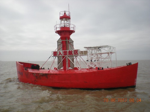
2012 (station establishment date unknown). Active; focal plane 10 m (33 ft); white flash every 10 s. 22 m (72 ft) steel lightship, painted red. Light tower with lantern and gallery amidships. An MSA photo is at right but the ship is not shown in Google's satellite view. The ship marks the beginning of the approach to Shànghǎi for ships arriving along the coast from the south. Located about 25 km (15 mi) east of Nánhuìjiāo (Cape Yangtze) and 50 km (30 mi) southeast of the Shànghǎi entrance. CN-2158; Admiralty P3750; NGA 18796.
Lightship Yíngkǒu
About 1915. Approx. 20 m (66 ft) steel lightship, formerly stationed off Yíngkǒu in Southwestern Liáoníng. In 2016 the the ship was transported to a shipyard in Shànghǎi to be restored; it was then placed display at the China Maritime Museum. Google has a satellite view. The museum is located near the point of Nánhuìjiāo (Cape Yangtze).

Jīnshān District Lighthouse
Jīnshān (Dàjīnshān, Dàjīnshāndǎo)
2009. Active; focal plane 105 m (344 ft); three white flashes every 10 s. Approx. 20 m (66 ft) round cylindrical tower with gallery, colored with red and white horizontal bands. Mǎ Zhòngyù has a very distant view from the mainland and Google has a satellite view. Located atop a small but high island in Hángzhōu Bay about 8 km (5 mi) off Jīnshān. Accessible only by boat. Site status unknown. CN-2263; Admiralty P3718.3; NGA 18886.
Lightship Nanzhi
Lightship Nánzhī, East China Sea, June 2012
PRC Shànghǎi Region Maritime Safety Administration photo

Information available on lost lighthouses:

Notable faux lighthouses:

Adjoining pages: North: Yánchéng and Nántōng | South: Shèngsì Islands | West: Jiāxīing

Return to the Lighthouse Directory index | Ratings key

Posted April 21, 2008. Checked and revised September 27, 2023. Lighthouses: 23, lightships: 6. Site copyright 2023 Russ Rowlett and the University of North Carolina at Chapel Hill.