Lighthouses of China: Jiāxīng, Zhèjiāng

The People's Republic of China (中华, Zhōnghuá in Chinese) has a lengthy coastline, many large harbors, and a large number of lighthouses. The country is divided into 23 provinces and 11 other province-level regions of various special types. The Chinese province of Zhèjiāng (formerly spelled Chekiang) occupies the central coast of the country, south of Shànghǎi and north of the Formosa Strait. The province faces east on the East China Sea. For the most part the coastline is hilly and irregular, with more than 3000 islands of all sizes offshore.

Hángzhōu Bay is a large funnel-shaped embayment at the northern end of the province. At its western end it narrows to the estuary of the Qiántángjiāng (Qiántáng River), which leads to the city of Hángzhōu. On its southern edge the Yǒngjiāng (Yǒng River) leads to the major port of Zhènhǎi and the city of Níngbō. Because of its funnel shape the bay is subject to a large tidal bore, much like Canada's Bay of Fundy. In 2007 China completed the 35.7 km (22.2 mi) long Hangzhou Bay Bridge across the bay.

Zhèjiāng is divided into eleven prefectural-level and subprovincial-level cities. This page describes lighthouses of the prefectural-level city of Jiāxīng, including the north coast of Hángzhōu Bay southwest of Shànghǎi. Also included are several lighthouses nearby on the southwest shore of the bay in Shàoxīng Prefecture and in Cíxī City in the northeastern corner of the subprovincial-level city of Níngbō.

There are many languages and dialects spoken in China, but Standard Chinese, often called Mandarin, is official. The pīnyīn system for transliterating Standard Chinese into Latin characters is now the international standard but some locations continue to be known also under the spellings of older transliteration systems. The Chinese word for a lighthouse is dēngtǎ (灯塔). In Standard Chinese jiāo (formerly chiao) is a reef or rock, jiǎo is a cape or headland, dǎo (tao) is an island; (tsu) or tuózi ("lump") is a small island, hǎi is a sea, wān is a bay, hǎixiá is a strait, or jiāng is a river, hékǒu ("river mouth") is an estuary, and gǎng (kang) is a harbor.

Lighthouses in China are maintained by the PRC Maritime Safety Administration. The administration is organized in four regional administrations, with offices in the major ports. All the lights on this page are maintained by the Zhènhǎi MSA office.

ARLHS numbers are from the ARLHS World List of Lights. CN numbers are Chinese light list numbers. Admiralty numbers are from volume P of the Admiralty List of Lights & Fog Signals. U.S. NGA List numbers are from Publication 112.

General Sources
Online List of Lights - China
Photos by various photographers posted by Alexander Trabas.
Chinese English Pinyin Dictionary
A useful tool for juggling the representations of Chinese names.
Navionics Charts
Navigation chart for Zhèjiāng.

Menshan Light
Ménshān Light, Haiyan
PRC Maritime Safety Administration photo
Jiāxīng Prefecture (Northern Hángzhōu Bay) Lighthouses

Pínghú City Lighthouses
Yìshān
Date unknown. Active; focal plane 20 m (66 ft); white flash every 2 s. 13 m (43 ft) round cylindrical white concrete tower. No photo available but Google has a satellite view. Located at a coal-fired power plant in Jīnshān. Site and tower closed. CN-2266.65; Admiralty P3718.498; NGA 18886.5.
Wàipúshān
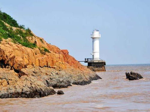
Date unknown. Active; focal plane 12.5 m (41 ft); white flash every 4 s. 10 m (33 ft) round masonry tower, painted white. A photo is at right and Google has a satellite view. Located on an island just off Jiǔlóngshān. The island is the site of a Buddhist temple and is connected to the mainland by a beautiful arched footbridge. Site status unknown. CN-2267; Admiralty P3718.5.
Guāncáijiāo (Coffin Reef)
Date unknown. Active; focal plane 13 m (43 ft); two white flashes every 5 s. 10 m (33 ft) round cylindrical concrete tower, painted black with one red horizontal band. No photo available but Bing has a satellite view. Located on a reef about 600 m (0.4 mi) south of the Wàipúshān light. Accessible only by boat. Site open, tower closed. CN-2267.1; Admiralty P3718.53; NGA 18887.
Càijishān
Date unknown. Active; focal plane 31 m (102 ft); three white flashes every 10 s. 5 m (17 ft) round cylindrical white concrete tower. No photo available but Bing has a satellite view. Located atop an island about 8 km (5 mi) east of the Hángzhōu Bay Bridge. Accessible only by boat. Site status unknown. CN-2268; Admiralty P3718.6.
Wángpánshān (Wángpán Shān, Xiàpánshān)
Date unknown. Active; focal plane 35 m (115 ft); two white flashes every 6 s. 11 m (36 ft) round fiberglass tower, colored with red and white horizontal bands. No photo available but Google has a satellite view. Wángpánshān is an islet near the western end of Hángzhōu Bay, about 16 km (10 mi) north of the Cíxī mainland, about 25 km (15 mi) south of Jīnshān, and 20 km (13 mi) east of the Hángzhōu Bay Bridge. Accessible only by boat. Site status unknown. CN-2289; Admiralty P3718.4.

Wàipúshān Light, Pínghú
Baide.com photo

Hǎiyán County Lighthouses
Báitǎshān
Date unknown. Active; focal plane 44.5 m (146 ft); white flash every 6 s. 14.5 m (48 ft) round cylindrical white concrete tower. No photo available but Google has a satellite view. Báitǎshān is the largest and southernmost of three islands off the west coat of Hángzhōu Bay. Accessible only by boat. Site status unknown. CN-2271.915; Admiralty P3718.487.
Ménshān (Mén Shān) (2?)
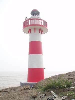
2007. Active; focal plane 17 m (56 ft); white flash every 3 s. 8 m (26 ft) round tower with lantern and gallery, painted with red and white horizontal bands. Shànghǎi MSA's photo is at the top of this page and Google has a satellite view. This light marks a sudden narrowing of the bay. Located on an island off a prominent cape about 10 km (6 mi) south of Haiyan. Accessible only by boat. Site status unknown. CN-2271.92; Admiralty P3718.489.
Dàwūzishān
Date unknown. Active; focal plane 52.5 m (172 ft); two white flashes every 6 s. 10 m (30 ft) round cylindrical concrete tower, painted white. No photo available but Google has a satellite view. Located atop an island off a promontory near Ganpuzhen. Accessible only by boat. Site status unknown. CN-2272; Admiralty P3718.488.

Hǎiníng City Lighthouses
Jiùcāng ("Old Barn")
Date unknown. Active; focal plane 11 m (36 ft); white flash every 3 s. 10.5 m (34 ft) round metal tower painted with black and white horizontal bands. No photo available but Google has a satellite view. Located on the north bank of the Qiántáng River in downtown Hǎiníng, a county-level city occupying the north bank of the river. Site status unknown. CN-2274.
Dīngqiáo
Date unknown. Active; focal plane 12.5 m (41 ft); white flash every 4 s. 10 m (33 ft) round barbell-shaped tower colored with black and white horizontal bands. No photo available but Google has a satellite view. Located on the north bank of the Qiántáng River in downtown Hǎiníng about 9 km (5.5 mi) west of the Jiùcāng lighthouse. Site status unknown. CN-2274.1.
Tóngxiāng Sewage Disposal (2 towers)
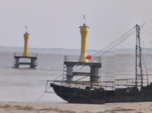
Date unknown. Active; focal plane 12 m (39 ft); four white flshes in a long-short-long-short pattern every 12 s. Two yellow barbell-shaped towers mounted in square platforms supported by piles. Jack Jin has the street view seen at right and Google has a satellite view. The lights apparently warn vessels about an submerged sewer pipeline owned by Tóngxiāng, a city on the north side of Hǎiníng. Located just off the north bank of the Qiántáng River about 1.7 km (1 mi) west of the Dīngqiáo light. Site open, tower closed. CN-2274.11 and 2274.12.
Yánguān
Date unknown. Active; focal plane 11 m (36 ft); two white flashes every 6 s. 9 m (30 ft) concrete tower colored with black and white horizontal bands. No photo available but Google has a satellite view. Located on the north bank of the Qiántáng River about 9 km (5.5 mi) east of the Mù Gǎng light. Site open, tower closed. CN-2275.
Mù Gǎng
Date unknown. Active; focal plane 11.5 m (37 ft); white flash every 3 s. 10.5 m (34 ft) round metal tower colored with black and white horizontal bands. No photo available but Google has a satellite view. Located on the north bank of the Qiántáng River in Hǎiníng about 16 km (10 mi) west of the Dīngqiáo lighthouse. Site status unknown. CN-2276.

Tóngxiāng Sewage Disposal Lights, Hǎiníng
Google Maps street view by Jack Jin

Shàoxīng Prefecture Lighthouses

Shàngyú District Lighthouse
Shàngyú Gǎng
Date unknown. Active; focal plane 31 m (102 ft); continuous white light. 31 m (102 ft) round concrete tower with lantern and gallery, painted white. No photo available but Google has a satellite view. This is a leading light seen only by ships approaching from the north northeast. Located at Shàngyú, about halfway between Hángzhōu and Zhènhǎi. Site status unknown. CN-2286.1; Admiralty P3716.695.

Níngbō Prefecture Lighthouses

Cíxī City Lighthouses
Xīsān
Date unknown. Active; focal plane 11.5 m (37 ft); white flash every 4 s. 7.5 m (25 ft) round concrete tower painted with black and white horizontal bands. No photo available but Google has a satellite view. Located at the end of a canal off the southwest coast of Hángzhōu Bay. Site status unknown. CN-2286.3.
Hǎihuángshān (2)
Date unknown. Active (?); focal plane 33 m (108 ft); flash every 6 s, white or red depending on direction. 6 m (20 ft) square cylindrical concrete tower with gallery, covered with ceramic tiles colored in black and white horizontal bands. Bing has a satellite view. This light was removed from the Admiralty list in 2021, but it may still be active. Located atop a hill (rare on this coast) about 35 km (22 mi) northwest of Zhènhǎi. Site status unknown. CN-2290; ex-Admiralty P3716.63.

Information available on lost lighthouses:

Notable faux lighthouses:

Adjoining pages: North: Shànghǎi | East: Shèngsì Islands | Southeast: Dìnghǎi District and Zhènhǎi

Return to the Lighthouse Directory index | Ratings key

Posted May 12, 2008. Checked and revised October 4, 2023. Lighthouses: 17. Site copyright 2023 Russ Rowlett and the University of North Carolina at Chapel Hill.