Lighthouses of China: Zhènhǎi, Zhèjiāng

The People's Republic of China (中华, Zhōnghuá in Chinese) has a lengthy coastline, many large harbors, and a large number of lighthouses. The country is divided into 23 provinces and 11 other province-level regions of various special types. The Chinese province of Zhèjiāng (formerly spelled Chekiang) occupies the central coast of the country, south of Shànghǎi and north of the Formosa Strait. The province faces east on the East China Sea. For the most part the coastline is hilly and irregular, with more than 3000 islands of all sizes offshore.

Hángzhōu Bay is a large funnel-shaped embayment at the northern end of the province. At its western end it narrows to the estuary of the Qiántángjiāng (Qiántáng River), which leads to the city of Hángzhōu. On its southern edge the Yǒngjiāng (Yǒng River) leads to the major port of Zhènhǎi and the city of Níngbō. Because of its funnel shape the bay is subject to a large tidal bore, much like Canada's Bay of Fundy. In 2007 China completed the 35.7 km (22.2 mi) long Hangzhou Bay Bridge across the bay.

Zhèjiāng is divided into eleven prefectural-level and subprovincial-level cities. This is one of six pages describing lighthouses of the prefectural-level city of Níngbō, a subprovincial city of more than 9.5 million residents on the south side of Hángzhōu Bay. It includes the lighthouses of Zhènhǎi, the port district of Níngbō.

Since Níngbō is large there is a separate page for the Xiàngshān Area in the eastern and southern portions of the city. The Directory also has a series of four pages covering the numerous islands of the Zhōushān archipelago, which is spread across the mouth of the bay. North to south these pages cover the Shèngsì Islands, the Dàishān Islands, the Dìnghǎi District and the Pǔtúo District.

There are many languages and dialects spoken in China, but Standard Chinese, often called Mandarin, is official. The pīnyīn system for transliterating Standard Chinese into Latin characters is now the international standard but some locations continue to be known also under the spellings of older transliteration systems. The Chinese word for a lighthouse is dēngtǎ (灯塔). In Standard Chinese jiāo (formerly chiao) is a reef or rock, jiǎo is a cape or headland, dǎo (tao) is an island; (tsu) or tuózi ("lump") is a small island, hǎi is a sea, wān is a bay, hǎixiá is a strait, or jiāng is a river, hékǒu ("river mouth") is an estuary, and gǎng (kang) is a harbor.

Lighthouses in China are maintained by the PRC Maritime Safety Administration. The administration is organized in four regional administrations, with offices in the major ports. All the lights on this page are maintained by the Zhènhǎi MSA office.

ARLHS numbers are from the ARLHS World List of Lights. CN numbers are Chinese light list numbers. Admiralty numbers are from volume P of the Admiralty List of Lights & Fog Signals. U.S. NGA List numbers are from Publication 112.

General Sources
Online List of Lights - China
Photos by various photographers posted by Alexander Trabas.
Chinese English Pinyin Dictionary
A useful tool for juggling the representations of Chinese names.
Navionics Charts
Navigation chart for Zhèjiāng.

Qili Light
1865 Qīlǐ Zhì (Square Island) Light, Zhènhǎi
Zhèjiāng Culture Ministry photo
Zhènhǎi District: Qīlǐ Zhì Lighthouses
Zhènhǎi's port facilities lie along both sides of the Yǒngjiāng (Yong River) near its mouth; the center of Níngbō is about 25 km (15 mi) upstream. British forces seized Zhènhǎi during the First Opium War in 1841 and the port was opened to western trade by the Treaty of Nanjing the following year.

*
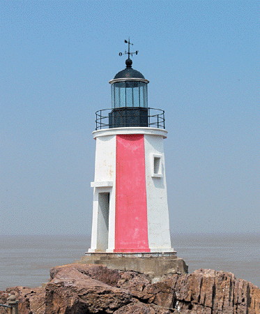
Qīlǐ Zhì (Tse-li, Square Island) (1) (relocated)
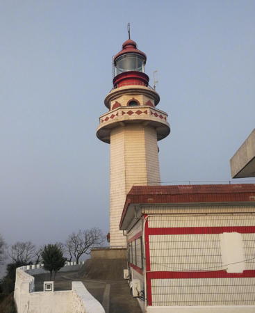
1865 (British). Inactive since 1997. 10 m (33 ft) octagonal stone tower with lantern and gallery, painted with red and white vertical stripes; lantern painted white with a black dome. A photo is at the top of this page, recent visitors describe the history of the lighthouse, and Google has a satellite view. Qīlǐ is a small island about 6 km (3.5 mi) northeast of the Yǒngjiāng and Zhènhǎi harbor entrance. After the new Qīlǐ lighthouse was built its historic predecessor was taken down in 1998 and rebuilt on Little Qīlǐ Island, just off the southwest tip of Qīlǐ and joined to it by a footbridge. Site open, tower closed.
Qīlǐ Zhì (Qīlǐ Yu, Square Island) (2)
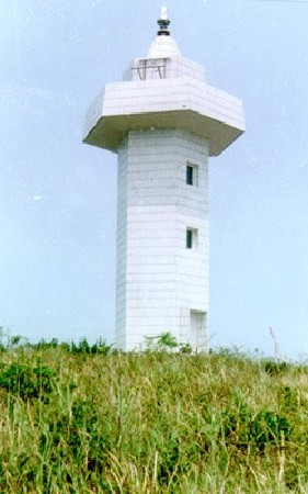
1997 (station established 1865). Active; focal plane 51 m (167 ft); white flash every 5 s. 25.5 m (84 ft) octagonal cylindrical concrete tower with lantern and double gallery. Fog siren. Several 1-story keeper's houses; this is a staffed station. Lighthouse covered with white tiles, lantern painted red. An MSA photo is at right, there's a video of a visit to the lighthouse, and Google has a satellite view. Located at the highest point of Qīlǐ. Accessible only by boat, but apparently transportation from Zhènhǎi is available. Site status unknown. ARLHS PRC-053; CN-2483; Admiralty P3716; NGA 18916.

Zhènhǎi District: Yǒngjiāng Estuary West Side Lighthouses
Yǒngjiāng North Breakwater
Around 2009. Active; focal plane 10 m (33 ft); quick-flashing green light. 11 m (36 ft) round hourglass-shaped fiberglass tower. Entire lighthouse is green. Zhāng Róngtiān has a photo and Google has a satellite view. Located on the north breakwater of the Yǒngjiāng estuary entrance in Zhènhǎi. Accessible only by boat. Site and tower closed. CN-2485; Admiralty P3715.3; NGA 18929.
Yǒngjiāng Fifth Groin
Date unknown. Active; focal plane 6 m (20 ft); two yellow flashes every 6 s. 6 m (20 ft) round cylindrical white fiberglass tower. This light is seen to the right of center in Zhāng Róngtiān's photo and Google has a satellite view. Located on a groin (usually submerged) just inside the Yǒngjiāng estuary entrance. Accessible only by boat. Site and tower closed. CN-2486; Admiralty P3714.93.

1997 Qīlǐ Zhì Light
k.sina.com photo
Hǔdūnshān (Hǔdūn Shān, Yǒngjiāng) Entrance Range Front (2)
2006 (station established 1985). Active; focal plane 38 m (125 ft); illuminated with neon lights showing red and yellow vertical stripes the entire length of the tower. 34 m (112 ft) tapered square skeletal tower. This light is visible above center (in front of the fuel tanks) in Jian Fang's aerial view and Google has a satellite view. Located in a waterfront area on the north side of the estuary entrance. Site status unknown. CN-2495; Admiralty P3715.2; NGA 18930.
Hǔdūnshān (Hǔdūn Shān, Yǒngjiāng) Entrance Range Rear (2)
2006 (station established 1985). Active; focal plane 51.5 m (169 ft); illuminated with neon lights showing red and yellow vertical stripes the entire length of the tower. 46 m (151 ft) tapered square skeletal tower. This light is to the left in Jian Fang's aerial view and Google has a satellite view. Located in a waterfront area on the north side of the estuary entrance. Site status unknown. CN-2496; Admiralty P3715.21; NGA 18930.1.
* Zhènhǎi Dùkǒu (Zhènhǎi Ferry)
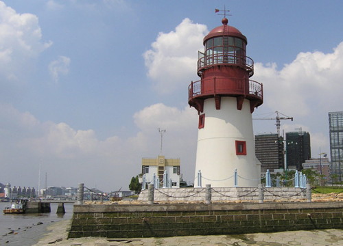
2006. Active; focal plane 12 m (39 ft); white flash every 10 s. 13 m (43 ft) round tower with lantern and gallery. Tower painted white with red trim, lantern and gallery painted red. The photo at right is from a former Shànghǎi MSA page on the construction of the lighthouse, a closeup photo is available, Chen Huang has a good view from the river, and Google has a satellite view. This new light was built in traditional form to honor Zhènhǎi's maritime heritage. Located on the west bank of the Yǒngjiāng near the traditional ferry crossing in Zhènhǎi; the ferry remains in service although there is now a bridge about 2 km (1.2 mi) downstream. Site open, tower closed. CN-2503.5; Admiralty P3714.965; NGA 18930.3.
Zhāngjiànqì Upstream Range Front
Date unknown. Active; focal plane 19 m (62 ft); continuous red light. 17.5 m (57 ft) square red skeletal tower. No photo available but Google has an indistinct satellite view. Located on the north bank of the river just south of the Yǒngjiāng Tunnel. Site status unknown. CN-2508; Admiralty P3715.36.
Zhāngjiànqì Upstream Range Rear
Date unknown. Active; focal plane 24 m (79 ft); continuous red light. 22.5 m (74 ft) square red skeletal tower. No photo available but Google has an indistinct satellite view. Located about 500 m (0.3 mi) west of the front light. Site status unknown. CN-2509; Admiralty P3715.361.
Zhāngjiànqì Downstream Range Front
Date unknown. Active; focal plane 19 m (62 ft); continuous red light. 14 m (46 ft) square skeletal tower. No photo available but Google has a distant satellite view. Located on the north bank of the river just south of the Yǒngjiāng Tunnel. Site status unknown. CN-2510; Admiralty P3715.362.
Zhāngjiànqì Downstream Range Rear
Date unknown. Active; focal plane 25 m (82 ft); continuous red light. 21 m (69 ft) square skeletal tower. No photo available but Google has a satellite view. Located about 400 m (1/4 mi) north of the front light. Site status unknown. CN-2511; Admiralty P3715.363.
Zhenhai Ferry Light
Zhènhǎi Ferry Light, Zhènhǎi, August 2006
PRC Maritime Safety Administration photo
Qīngshuǐpǔ Upstream Range Front (?)
Date unknown. Active; focal plane 15 m (49 ft); continuous red light. 15 m (49 ft) skeletal tower atop a square masonry tower. No photo available and Google's satellite view shows that the light has been removed, perhaps temporarilyfor a construction project. Located on the waterfront about 800 m (1/2 mi) east of the Mingzhou Bridge. Site status unknown. CN-2518; Admiralty P3715.364.
 
Qīngshuǐpǔ Range Common Rear
Date unknown. Active; focal plane 19.5 m (64 ft); continuous red light. 19 m (62 ft) skeletal tower atop a square masonry tower. No photo available but Google has a satellite view. Located on the north side of the Míngzhōu Bridge about 300 m (0.3 mi) west of the upstream front light. Site status unknown. CN-2519; Admiralty P3715.365.
Qīngshuǐpǔ Downstream Range Front
Date unknown. Active; focal plane 15 m (49 ft); continuous red light. 15 m (49 ft) skeletal tower atop a square masonry tower. No photo available but Google has a satellite view. Located on the waterfront about 250 m (1/8 mi) south of the rear light and close to the Míngzhōu Bridge. Site status unknown. CN-2520; Admiralty P3715.366.
* Méixū
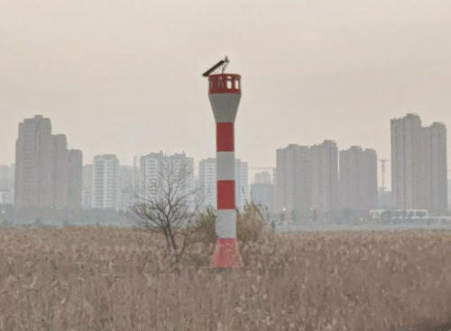
Date unknown. Active; focal plane 12.5 m (41 ft); two white flashes every 4 s. 11 m (36 ft); round barbell-shaped tower colored with red and white horizontal bands. A portion of a Google street view is at right and Google also has a satellite view. Located on the inside of a horseshoe bend of the Yǒngjiāng estuary. Site open, tower closed. CN-2521; Admiralty P3715.375.
Lǐjiā'ān Downstream Range Rear
Date unknown. Active; focal plane 18 m (59 ft); continuous red light. Approx. 16 m (52 ft) white skeletal tower. No photo available but Google has a satellite view. Located in front of a 6-story building about 1.5 km (1 mi) north of the Méixū bend. Site status unknown. CN-2529.5; Admiralty P3715.3701.
 

Méixū Light, Zhènhǎi, December 2019
Google Maps street view
Lǐjiā'ān Downstream Range Front
Date unknown. Active; focal plane 14 m (46 ft); continuous red light. 14 m (46 ft) white skeletal tower. No photo available but Google has an indistinct satellite view. Located on the waterfront about 300 m (0.3 mi) west of the rear light. Site status unknown. CN-2530; Admiralty P3715.37.
 

Běilún District: Yǒngjiāng Estuary East Side Lighthouses
Méixū Chōngbīngtǎ
Date unknown. Active; focal plane 13 m (43 ft); two red flashes every 6 s. 10 m (33 ft) round red barbell-shaped tower. Google has a satellite view and a very distant street view across the river. Located on a wharf opposite the Méixū lighthouse (see above). Site and tower closed. CN-2521.1; Admiralty P3715.378.
Wángjiāyáng Downstream Range Front
Date unknown. Active; focal plane 15 m (49 ft); continuous red light. 15 m (49 ft) skeletal tower atop a square masonry tower. Míng Jiàn has a street view and Google has a satellite view. Located on the waterfront on the east side of the estuary on the south side of the Wángjiāyáng Bridge. Site status unknown. CN-2516; Admiralty P3715.352.
Wángjiāyáng
Date unknown. Active; focal plane 9 m (30 ft); red flash every 2 s. 7.5 m (25 ft) round barbell-shaped tower colored with red and white horizontal bands. Míng Jiàn has a street view and Google has an indistinct satellite view. Located on the riverbank just downstream from the Wángjiāyáng Bridge. Site status unknown. CN-2513; Admiralty P3715.353.
Wángjiāyáng Range Common Rear
Date unknown. Active; focal plane 19.5 m (64 ft); continuous red light. 19 m (62 ft) skeletal tower atop a square masonry tower. No photo available but Google has Míng Jiàn's street view and a satellite view. Located on the north side of the eastern approach to the Wángjiāyáng Bridge. Site status unknown. CN-2515; Admiralty P3715.351.
Wángjiāyáng Upstream Range Front
Date unknown. Active; focal plane 15 m (49 ft); continuous red light. 15 m (49 ft) skeletal tower atop a square masonry tower. This tower is centered in Míng Jiàn's very distant street view and Google has a satellite view. Located on the waterfront on the east side of the estuary on the north side of the Wángjiāyáng Bridge. Site status unknown. CN-2514; Admiralty P3715.35.
* Jiāngnándàotóu
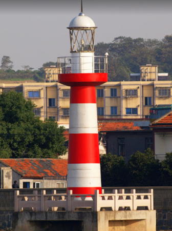
Date unknown. Active; focal plane 13 m (43 ft); two red flashes every 4 s. 12 m (39 ft) round tower with lantern and gallery, mounted on a square concrete pier. Lighthouse painted with red and white horizontal bands. Jim Bowen has the closeup photo seen at right and Google has a satellite view. Located on the east side of the Yǒngjiāng near a bend in the estuary and almost directly across from the Zhènhǎi Ferry lighthouse (see above). Site open, tower closed. CN-2504; Admiralty P3714.97.

Jiāngnándàotóu Light, Zhènhǎi, October 2011
Google Maps photo by Jim Bowen
Yǒngjiāng South First Groin
Date unknown. Active; focal plane 8.5 m (28 ft); white flash every 2 s. 8 m (26 ft) round cylindrical fiberglass tower colored with black and white horizontal bands. The light is in the lower right corner of a photo of the Zhāobǎoshān Bridge and Google has a satellite view. Located on a groin (usually submerged) just south of the east end of the bridge. Accessible only by boat. Site and tower closed. CN-2502; Admiralty P3714.95.
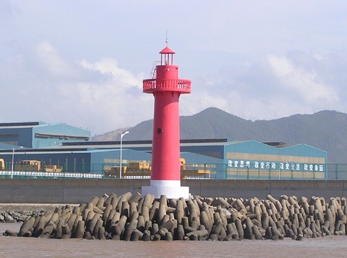
Yǒngjiāng South Dyke Spur (2)
2006 (station established 1983). Active; focal plane 11 m (36 ft); quick-flashing red light. 11 m (36 ft) round concrete tower with lantern and gallery, painted red. Shànghǎi MSA's photo is seen at right and Google has a satellite view. The lighthouse replaced a red skeletal tower. Located at the end of breakwater dike on the southeast side of the Yǒngjiāng entrance. Site and tower closed. CN-2488; Admiralty P3714.9.
* Zhǎngtiàozuǐ (Changtiaozui) (2)
1993 (station establishment date unknown). Active; focal plane 18 m (59 ft); four white flashes every 12 s. 16 m (52 ft) hexagonal cylindrical concrete tower with gallery, rising from a square pyramidal concrete base. Lighthouse covered with ceramic times and colored with red and white vertical stripes. Zhāng Róngtiān has a view from the sea and Google has a satellite view. The light from this tower must be somewhat obscured by recent development of the waterfront. Located in an industrial zone on the east side of the entrance to the Yǒngjiāng and the harbor of Zhènhǎi. Accessible by road. Site probably open, tower closed. ARLHS PRC-012; CN-2484; Admiralty P3715; NGA 18928.
Suànshān Tanker Terminal Range Front
Date unknown. Active; focal plane 73 m (240 ft); continuous red light. 20 m (66 ft) square skeletal tower carrying a rectangular daymark colored white with a black vertical stripe. No photo available but Google has a satellite view. Located in a large petroleum tank farm on the east side of Zhènhǎi. The rear light is on a much shorter tower. Site and tower closed. CN-2402.01; Admiralty P3714.4.
Yongjiang South Dyke Light
Yǒngjiāng South Dyke Spur Light, Zhènhǎi
PRC Maritime Safety Administration photo

Zhènhǎi District: Huángmǎng Islands Lighthouses
The Huángmǎng islands are located in the passage between the mainland and Jīntáng island (see the Dìnghǎi District page), east of the Yǒngjiāng entrance.

Zhōngzhùshān (Zhōngzhù Shān)
Date unknown. Active; focal plane 47 m (154 ft); three white flashes every 10 s. 12 m (39 ft) round cylindrical white concrete tower with gallery. No photo available but Google has a satellite view. Located on Zhōngzhùshān, the westernmost of the Huángmǎng Islands, about 1.5 km (1 mi) west of the Dàhuángmǎng lighthouse. Accessible only by boat. Site status unknown. CN-2402.5; Admiralty P3714.6; NGA 18922.
Ejiāo (Níngbō Gang)
Date unknown. Active; focal plane 16 m (52 ft); two white flashes every 5 s. 12.5 m (41 ft) robust square cylindrical skeletal tower with gallery, mounted on a square concrete pier. Lighthouse painted black with a broad red horizontal band. No photo available but Google has a satellite view. Located on a reef about 800 m (1/2 mi) north of Dàhuángmǎng island, about 7 km (4.5 mi) east of the Yǒngjiāng entrance and a similar distance east southeast of Qīlǐ. Accessible only by boat. Site open, tower closed. CN-2401.8; Admiralty P3715.6; NGA 18919.
Dàhuángmǎng (Huángmǎng Shān) (2)
Date unknown. Active; focal plane 80 m (262 ft); two white flashes every 6 s. 8 m (26 ft) square pyramidal white concrete tower. No photo available but Google has a satellite view. Located on the highest point of Dàhuángmǎng, about 7 km (4.5 mi) east of the Yǒngjiāng entrance. Accessible only by boat. Site status unknown. CN-2402; Admiralty P3715.4; NGA 18920.

Běilún District: Dàxièdǎo Area Lighthouses
Dàxièdǎo is an island about 7 km (4.5 mi) in diameter, lying just off the mainland coast about 30 km (19 mi) east of Zhènhǎi. The island is connected to the mainland by a bridge and is being developed as a port to relieve pressure on Zhènhǎi and Níngbō. These lighthouses guide vessels in the passage, about 6 km (3.5 mi) wide, between Dàxièdǎo and Dàmāodǎo (see also the Dìnghǎi District page).

Túnízuǐ (Túníméndǎo, Túnímén Dǎo, Tuni Zui) (2)
1998 (station establishment date unknown). Active; focal plane 15 m (49 ft); three white flashes every 6 s. 8 m (26 ft) round concrete tower with gallery, covered with white ceramic tile. No photo available but Google has a satellite view. Located on a small island just off the northern tip of Dàxièdǎo. Accessible only by boat. Site status unknown. CN-2424; Admiralty P3714.28; NGA 18968.
Dàxièdǎo (Daxie Dǎo)
Date unknown. Active; focal plane 10 m (33 ft); quick-flashing green light. 6 m (20 ft) round hourglass-shaped fiberglass tower, colored green, mounted on a round concrete pier. No photo available but Google has an indistinct satellite view. Located just off a large oil terminal on the eastern point of Dàxièdǎo. Accessible only by boat. Site status unknown. CN-2433.1; Admiralty P3714.266; NGA 18976.
Báiyāshān (Liàngmáoshān) North
Date unknown. Active; focal plane 14 m (46 ft); white flash every 2 s. 7.5 m (25 ft) round white concrete tower. No photo available but Google has an indistinct satellite view. Located at the northern tip of Liàngmáoshān ("Cold Hat Mountain"), an island off the east coast of Dàxièdǎo. Accessible only by boat. Site open, tower closed. CN-2433.3; Admiralty P3714.263.
Xiǎobáiyājiāo (Xiǎobáiyā Jiāo, Yazhao Jiāo)
Date unknown. Active; focal plane 6 m (20 ft); white flash every 3 s. 8 m (26 ft) round concrete tower, painted black. No photo available but Google has a satellite view. Located on a reef off Wàishēnmǎdǎo, a small island off the southeastern tip of Dàxièdǎo. Accessible only by boat. Site open, tower closed. CN-2446; Admiralty P3714.265.

Běilún District: Zhitou Jiǎo (Cape Ketau) Area Lighthouses
Zhǐtou Jiǎo (Cape Ketau, or literally "Finger Cape"), at the end of the Chuanshān Peninsula about 65 km (40 mi) east of Zhènhǎi, is the easternmost point of the mainland south of Hángzhōu Bay.

Chángbǐngjǔ (Changbingzui)
Date unknown. Active; focal plane 21 m (69 ft); white flash every 6 s. 6 m (20 ft) round white fiberglass tower. No photo available but Google has a satellite view. Located atop a tiny island (now connected to the mainland by a pier) on the north side of Zhǐtou Jiǎo. Site and tower closed. CN-2446.6; Admiralty P3714.225.
Yángxiǎomāodǎo (Yángxiǎomāo Dǎo) (2)
1991 (station establishment date unknown). Active; focal plane 49 m (160 ft); two white flashes every 10 s. 11 m (36 ft) hexagonal cylindrical concrete tower with gallery. Lighthouse covered with white ceramic tiles. MSA's photo is at right, the light is barely visible atop the island in Jason Chao's view, and Google has a satellite view. Located on Yángxiǎomāodǎo, a small island about 2.5 km (1.5 mi) off Zhǐtou Jiǎo. Accessible only by boat, and landing is difficult. Site and tower closed. CN-2473; Admiralty P3714.22; NGA 18956.
Yangxiaomaodao Light
Yangxiaomaodǎo Light, Zhitou Jiǎo
PRC Maritime Safety Administration photo

Běilún District: Méishāndǎo Area Lighthouses
Méishāndǎo is an island just off the south side of the Chuanshān Peninsula. The channel between the island and the mainland is dammed at each end, with locks to admit small craft.

Méishān Yězhūjiāo
Date unknown. Active; focal plane 14.5 m (48 ft); green flash every 4 s. 7.5 m (25 ft) round concrete tower painted green. No photo available but Google has a satellite view. Located atop a tiny island about 3 km (1.8 mi) south of the southwestern tip of Méishāndǎo. Accessible only by boat. Site open, tower closed. CN-2534.1; Admiralty P3692.3.
Méishān Fēnshuǐjiāo
Date unknown. Active; focal plane 9 m (30 ft); two white flashes every 5 s. 5.5 m (18 ft) round barbell-shaped metal tower painted black with a red horizontal band. The light is near the right edge of a distant 2022 view and Google has a satellite view. Fēnshuǐ means "breaking water," referring to surf on the reef. Located on a reef just off the southwestern tip of Méishāndǎo. Accessible only by boat. Site open, tower closed. CN-2534.18; Admiralty P3692.32.

Information available on lost lighthouses:

Notable faux lighthouses:

Adjoining pages: North: Shànghǎi | East: Dìnghǎi District | South: Xiangshān Area

Return to the Lighthouse Directory index | Ratings key

Posted May 12, 2008. Checked and revised November 9, 2023. Lighthouses: 38. Site copyright 2023 Russ Rowlett and the University of North Carolina at Chapel Hill.