Lighthouses of Northeastern Colombia

The Republic of Colombia occupies the northwestern corner of South America. Connected to North America by the Isthmus of Panama, Colombia has coasts facing west on the Pacific Ocean and northwest on the Caribbean Sea. Colombia was colonized by Spain early in the 16th century and was ruled as part of the Viceroyalty of New Granada until the viceroyalty won its independence in a complex struggle in 1810-1819. The former viceroyalty, known as Gran Colombia, fell apart in 1831, creating the nations of Colombia, Venezuela, and Ecuador. Colombia continued to include the area of Panama until that country became independent in 1903.

Colombia is divided into 33 departments (departamentos). This page includes the lighthouses of the eight mainland departments of the Colombian Caribbean; there are separate pages for the Pacific Coast and for the Caribbean island department of San Andrés and Providencia.

The word for a lighthouse is faro in Spanish; smaller lighthouses are often called balizas (beacons). In Spanish isla is an island, cabo is a cape, punta is a promontory or point of land, péñon is a rock, arrecife is a reef, bahía is a bay, ría is an estuary or inlet, estrecho is a strait, río is a river, and puerto is a port or harbor.

Aids to navigation in Colombia are owned by the Autoridad Marítima Colombia and maintained by the Dirección General Marítima (DIMAR).

ARLHS numbers are from the ARLHS World List of Lights. DIMAR numbers are from DIMAR's Lista de Luces de la República de Colombia. Admiralty numbers are from volume J of the Admiralty List of Lights & Fog Signals and U.S. NGA numbers are from Publication 110.

General Sources
Online List of Lights - Colombia - North Coast
Photos by Capts. Peter Mosselberger and Theo Hinrichs and by Michael Boucher, posted by Alexander Trabas.
Lighthouses in Colombia
Photos by various photographers available from Wikimedia.
World of Lighthouses - Colombia
Photos by various photographers available from Lightphotos.net.
Leuchttürme Südamerikas auf historischen Postkarten
Historic postcard views posted by Klaus Huelse.


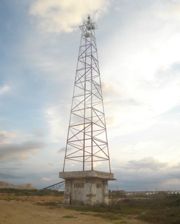
Santa Marta Light, Santa Marta, April 2022
Google Maps photo by Alberto Redondo

Atlántico Department (Barranquilla Area) Lighthouses
Barranquilla, the capital of the Atlántico Department, is the largest city of Colombia's coastline, with a population of more than 1.2 million and a metropolitan population of nearly 2.5 million. The city is located at the head of the delta of the Río Magdalena, about 8 km (5 mi) from the mouth of the river. The river is also the boundary between the Departments of Atlántico and Magdalena. Navigation on the river is guided by a numerous range lights; only the tallest ones are listed here.

Punta Hermosa (2)
1969 (station established 1925). Active; focal plane 134 m (440 ft); three white flashes, separated by 3 s, every 20 s. 12 m (39 ft) square pyramidal tower, painted with red and white horizontal bands, mounted on a 1-story square concrete equipment building. The equipment building is covered with tiles colored with blue and white vertical stripes. No photo available but Google has a satellite view of the light station. Located on a headland near Barranquilla. Site status unknown, tower closed. ARLHS COL-045; DIMAR-032; Admiralty J6180; NGA 16744.
Río Magdalena F-2 (West Breakwater)
Date unknown (station established 1937). Active; focal plane 23 m (75 ft); red light, 1 s on, 1 s off. 22 m (72 ft) square skeletal tower, pyramidal below and cylindrical above, painted with red and white horizontal bands. Trabas has Capt. Theo's 2014 photo (also seen at right), Adolfo Moreno has a 2016 street view, and Bing has an indistinct satellite view. This is the entrance light for the Magdalena estuary leading to the port of Barranquilla. The rubblestone west breakwater at the mouth of the estuary is nearly 8 km (5 mi) long. Located at the end of the breakwater. Site open, tower closed. ARLHS COL-049; DIMAR-014; Admiralty J6188; NGA 16748.
Río Magdalena E-8 (Range Rear)
Date unknown. Active; focal plane 24 m (79 ft); blue light, 2 s on, 2 s off. 22 m (72 ft) square skeletal tower, mounted on a square platform. Lighthouse painted with red and white horizontal bands. The tower also carries a slatted daymark painted red with a white vertical stripe. Trabas has Capt. Peter's 2024 photo and Bing has a distant satellite view. This is the entrance range for the river. 6191.91; NGA 16788.
Río Magdalena E-6 (Range Front) (2)
Date unknown. Active; focal plane 11 m (36 ft); blue light, 1 s on, 1 s off. 10 m (33 ft) square skeletal tower,. The tower also carries a slatted daymark painted red with a white vertical stripe. Trabas has Capt. Peter's 2024 photo and Google has a satellite view. DIMAR-203; Admiralty J6191.9; NGA 16784.
San Nicolas Leading (Río Magdalena E-12 and E-14)
Date unknown. Active; focal plane 24 m (79 ft); a green light (E-12), 2.5 s on, 2.5 s off, is a leading light for southbound ships; a blue light (E-14), 3 s on, 3 s off, for general traffic. 22 m (72 ft) square skeletal tower, mounted on a square platform. Lighthouse painted with red and white horizontal bands. The tower also carries two slatted daymarks painted white with a red vertical stripe. Trabas has Capt. Peter's 2019 photo and Google has a satellite view. This is a leading light for outbound vessels. Located on an embankment west of the Magdalena channel. Site open, tower closed. DIMAR-206 (E-12) and 207 (E-14); Admiralty J6192.1; NGA 16790.5.

Río Magdalena West Breakwater Light, Barranquilla, September 2014
photo copyright Capt. Theo Hinrichs; used by permission

Magdalena Department Lighthouse
Santa Marta, the capital of the Magdalena Department, is the oldest city in Colombia, founded in 1525. Its historic district is a major tourist attraction. The port ships bananas and other agricultural products. The city's population is about 500,000.

Río Magdalena F-1 (East Breakwater)
Date unknown. Active; focal plane 24 m (79 ft); green light, 2 s on, 5 s off. 23 m (75 ft) square skeletal tower, lower half pyramidal and upper half cylindrical, painted with red and white horizontal bands. Trabas has Capt. Peter's 2024 photo (seen at right) and Google has an indistinct satellite view and a distant 2014 street view. Located at the end of the breakwater. Site open, tower closed. DIMAR-013; Admiralty J6190; NGA 16747.
Río Magdalena E-1 (Approach Range Common Front) (2)
Date unknown. Active; focal plane 11 m (36 ft); blue light, 1 s on, 1 s off. 10 m (33 ft) round metal or fiberglass tower colored with red and white horizontal bands. Monica Andrea Lemos has a distant photo but the light is hard to distinguish in Google's satellite view. Trabas has Capt. Peter's photo of the original front light, a skeletal tower. Located midway on the East Breakwater. Site open, tower closed. DIMAR-196; Admiralty J6191; NGA 16756.
Río Magdalena E-3 (Approach Range Rear)
Date unknown. Active; focal plane 22 m (72 ft); blue light, 2.5 s on, 2.5 s off. 20 m (66 ft) square skeletal tower, painted with red and white horizontal bands. The tower also carries a slatted daymark painted white with a red vertical stripe. Trabas has Capt. Peter's 2017 photo and Google has a satellite view. The front light is on a much shorter skeletal tower. Located beside the east breakwater at the entrance to the Magdalena. Site open, tower closed. DIMAR-197; Admiralty J6191.1; NGA 16760.
Río Magdalena E-3A (Second Approach Range Rear)
Date unknown. Active; focal plane 22 m (72 ft); white light, 1.5 s on, 1.5 s off. 20 m (66 ft) square skeletal tower, painted with red and white horizontal bands. The tower also carries a slatted daymark painted white with a red vertical stripe. Trabas has Capt. Peter's 2017 photo and Bing has an indistinct satellite view. The front light is on the same tower as the front light of the first approach range. Apparently vessels are making a proper approach if they see the front light between the two rear lights. Located beside the east breakwater at the entrance to the Magdalena. Site open, tower closed. DIMAR-198; Admiralty J6191.2; NGA 16761.
Puerto Barranquilla Leading (Río Magdalena E-7) (2)
2018. Active; focal plane 23 m (75 ft); white, red or green light, depending on direction, 2.5 s on, 2.5 s off. 23 m (75 ft) square skeletal tower painted red with a white horizontal band. Trabas has Capt. Peter's 2024 photo and Google has a satellite view. This was formerly the front light of a range; the range tower was replaced in 2018 by the current tower. The light guides vessels in the river past the Barranquilla waterfront. Located on the east bank of the Río Magdalena opposite the waterfront. DIMAR-217; Admiralty J6229.51; NGA 16818.

East Breakwater Light F-1, Río Magdalena, February 2024
photo copyright Capt. Peter Mosselberger, used by permission
Santa Marta (Morro Grande, Isla del Morro) (2)
1971 (station established 1870). Active; focal plane 82 m (269 ft); three white flashes every 15 s. 23 m (75 ft) hexagonal tower on a 2-story square base; the lighthouse is built of cement blocks with a frame of reinforced concrete. Lighthouse painted gray with white trim; the lantern has red and white vertical striping. Alberto Redondo has the 2022 photo seen at the top of this page, Trabas has a 2020 photo by Capt. Peter, Ronald Bellorin has a 2010 photo, William Pinzon Paez has a 2022 drone view, Lightphotos.net has a view from the sea, and Google has a satellite view. Huelse has a historic postcard view of the original lighthouse. Located on a steep-sided island in the entrance to the harbor of Santa Marta. Accessible only by boat. Site and tower presumably closed. ARLHS COL-028; DIMAR-012; Admiralty J6256; NGA 16832.
La Guajira Department (Guajira Peninsula) Lighthouses
Projecting northwestward into the Caribbean Sea, the broad Guajira Peninsula is the northernmost region of the South American mainland. Most of the peninsula is in Colombia, but the southeastern coast is in Venezuela.

Puerto Brisa
Date unknown. Active (privately maintained); focal plane 30 m (98 ft); white, red or green light depending on direction, 4 s on, 1 s off. Approx. 23 m (75 ft) white skeletal tower. Trabas has Capt. Peter's 2020 photo and Google has a satellite view. Puerto Brisa is primarily a coal terminal; it was developed by a consortium of public and private agencies. Located on the east side of the port facilities, about 80 km (50 mi) east of Santa Marta. Site and tower closed. Owner/site manager: Zona Franca Brisa. DIMAR-104; Admiralty J6265; NGA 16835.
* Riohacha (Río de la Hacha) (2?)
1986 (station established 1857). Active; focal plane 35 m (115 ft); white flash every 10 s. 30 m (98 ft) square pyramidal steel skeletal tower, painted with red and white horizontal bands. João Gomez has the photo at right, and Google has a street view and a satellite view. Located on the waterfront on the west side of Riohacha, the capital of the La Guajira Department, about 150 km (90 mi) east of Santa Marta. Site appears open, tower closed. ARLHS COL-050; DIMAR-011; Admiralty J6262; NGA 16836.
* Riohacha (Río de la Hacha) (1)
1857. Inactive at least since 1986. Light formerly mounted on the tower of the cathedral of Nuestra Señora de los Remedios. Google has a street view and a satellite view. Located in downtown Riohacha. Site and church open, tower closed.
Puerto Manaure
Date unknown. Active; focal plane 27 m (89 ft); two white flashes every 15 s. 18 m (59 ft) square pyramidal steel skeletal tower, painted with red and white horizontal bands and mounted on a square 1-story concrete equipment building. DIMAR has a photo and Google has a satellite view. Located on a headland on the east side of Manaure, a salt-mining town on the west side of the Guajira Peninsula. Site status unknown. ARLHS COL-044; DIMAR-010 Admiralty J6260; NGA 16840.
* [Cabo de la Vela] (2)
1955 (station established 1928). Active; focal plane 88 m (289 ft); white flash every 10 s. 8 m (26 ft) square skeletal tower, painted red. A closeup photo is available, Trabas has Capt. Peter's 2017 photo, Emilie Baird de Vargas has posted a distant view, Adolfo Moreno has a street view, and Google has a satellite view. Foundation ruins near the tower must be from the earlier lighthouse and/or keeper's house. Cabo de la Vela is a resort area and tourists can hike to the lighthouse to enjoy the spectacular view. Site open, tower closed. ARLHS COL-016; DIMAR-009; Admiralty J6266; NGA 16844.
Punta Gallinas
1989. Active; focal plane 21 m (69 ft); white flash every 10 s. 18 m (59 ft) square skeletal tower, painted with horizontal red and white bands. A 2016 photo is available, Trabas has Capt. Peter's 2017 photo, Luis Fernando Acosta Bernal has a photo, Ilan Gutman has a street view, and Google has a satellite view. The ruined building nearby is presumably a former keeper's house. This tower is the northernmost lighthouse of South America, standing at latitude 12° 27.5' north. Located on the cape at the northern tip of the Guajira Peninsula, about 18 km (11 mi) north of Inosu. Accessible by 4WD. Site open, tower closed. ARLHS COL-042; DIMAR-006; Admiralty J6267; NGA 16848.

Riohacha Light, Riohacha, September 2017
Google Maps photo by João Gomez
Chimaré
2001. Active; focal plane 25 m (82 ft); one long (1.2 s) white flash every 12 s. 18 m (59 ft) square pyramidal steel skeletal tower, painted with red and white horizontal bands. Trabas has Capt. Peter's 2018 view from the sea and Google has an indistinct satellite view. Located about 8 km (5 mi) west of Puerto Chimaré. Site status unknown. ARLHS COL-038; DIMAR-005; Admiralty J6267.3; NGA 16848.2.
Puerto Estrella
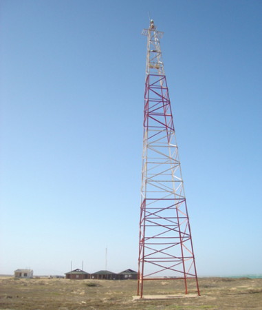
2002. Active; focal plane 26 m (85 ft); white flash every 15 s. 18 m (59 ft) square pyramidal steel skeletal tower, painted with red and white horizontal bands. A 2022 photo by Josue Wilson Rico Hernandez is at right, Trabas has Capt. Peter's 2018 photo, Yeiner Zabaleta Diaz has a view, and Google has a satellite view. Located on a promontory sheltering Puerto Estrella. Site open, tower closed. ARLHS COL-033; DIMAR-004; Admiralty J6267.4; NGA 16848.3.
Chichibacoa
2001. Active; focal plane 20 m (66 ft); white flash every 10 s. 18 m (59 ft) square pyramidal steel skeletal tower, painted with red and white horizontal bands. Trabas has Capt. Peter's 2018 view from the sea and Google has a satellite view. Located near a point of land at Chichibacoa. Site status unknown. ARLHS COL-024; DIMAR-003; Admiralty J6267.6; NGA 16848.4.
Punta Espada
Date unknown. Active; focal plane 50 m (164 ft); one long (1.6 s) white flash every 20 s. 18 m (59 ft) square pyramidal steel skeletal tower, painted with red and white horizontal bands. Trabas has Capt. Peter's 2018 distant view and Google has a satellite view of the station. The lighthouse marks the easternmost point of the Guajira Peninsula. The light characteristic was changed in 2011. Located on a bluff above the cape. Site status unknown. ARLHS COL-040; DIMAR-002; Admiralty J6267.8; NGA 16849.
Castilletes
Date unknown. Active; focal plane 35 m (115 ft); white flash every 9 s. 30 m (108 ft) square pyramidal steel skeletal tower, painted with red and white horizontal bands. A 1-story border control station stands a short distance north of the lighthouse. DIMAR has a photo and Google has a satellite view. Located about 600 m (3/8 mi) north of the Venezuelan border on the southeast side of the Guajira Peninsula. Site open, tower closed. ARLHS COL-019; DIMAR-001; Admiralty J6268; NGA 16850.

Puerto Estrella Light, Guajira, April 2022
Google Maps photo by Josue Wilson Rico Hernandez

Information available on lost lighthouses:

Adjoining pages: East: Western Venezuela | Southwest: Northwestern Colombia

Return to the Lighthouse Directory index | Ratings key

Posted February 13, 2004. Checked and revised June 2, 2025. Lighthouses: 21. Site copyright 2025 Russ Rowlett and the University of North Carolina at Chapel Hill.