Lighthouses of Denmark: Sjælland Region

The Kingdom of Denmark (Danmark in Danish), located at the mouth of the Baltic Sea, includes the north-pointing peninsula of Jylland (Jutland) in the west and a large number of islands to the east. The capital, Copenhagen, is on the island of Sjælland. Other major Danish islands include Fyn (between Sjælland and Jylland), Lolland and Falster (south of Sjælland) and Bornholm (farther east in the Baltic). The Skaggerak is a sound separating Jylland from Norway to the northwest, while the Kattegat separates Jylland from Sweden to the northeast.

Denmark is divided into five regions. This page covers the lighthouses of the Sjælland (Zealand) Region, which includes all of Sjælland except the København metropolitan area plus the islands of Lolland, Falster, and Møn to the south. The region is divided into 17 municipalities.

The Danish word for a lighthouse is fyr or fyrtårn. The front light of a range is the forfyr and the rear light is the bagfyr. Næs is a cape, odde a narrow promontory or isthmus, ø is an island, bugt is a bay, rev is a reef, fjord is an inlet, and havn is a harbor.

Danish aids to navigation are maintained by the Danish Maritime Authority (Søfartsstyrelsen).

ARLHS numbers are from the ARLHS World List of Lights. DFL numbers are from the Dansk Fyrliste (Danish Light List). Admiralty numbers are from volume C of the Admiralty List of Lights & Fog Signals. U.S. NGA List numbers are from Publication 116.

General Sources
Danske Fyrtårne
A comprehensive site on Danish lighthouses by Ole Henrik Lemvigh, with many photos; the text is entirely in Danish.
Online List of Lights - Denmark East
Photos by various photographers posted by Alexander Trabas.
Leuchttürme.net - Dänemark
A fine web site by Malte Werning, with excellent photos.
Leuchtturmseiten von Anke und Jens - Denmark
Photos of more than 100 Danish lighthouses, with notes in English.
Dänische Leuchttürme
Photos of more than 175 Danish lighthouses posted by Klaus Huelse.
Lighthouses in Denmark
Photos by various photographers available from Wikimedia.
World of Lighthouses - Denmark
Photos by various photographers available from Lightphotos.net.
Denmark Lighthouses
Aerial photos posted by Marinas.com.
Dänische Leuchttürme auf historischen Postkarten
Historic postcard views posted by Klaus Huelse.
Dansk Fyrliste 2022
Official Danish light list (in .pdf format); the list also includes lights of Greenland and Faroes.
OpenSeaMap
Navigational chart information for Denmark.
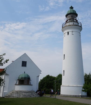

Old and new Stevns Lights, Stevns, July 2021
Wikipedia Creative Commons photo by Erik Cleves Kristensen

Køge and Stevns Municipalities (Southeast Sjælland) Lighthouses

* Køge (Sankt Nicolai Kirke)
Date unknown (church dates from the mid 15th century). For several centuries a lantern was hung from the tower of the Sankt Nicolai Kirke (St. Nicholas Church) as a guide to sailors entering the harbor. Philippe Gault has a photo and Google has a street view and a satellite view. Located on the Kirkestræde in downtown Køge. Site open, tower closed.
** Stevns Klint (1)
1818. Inactive since 1878. Semicircular lantern room attached to one end of a 1-1/2 story masonry keeper's house. House painted white; lantern dome is greenish metallic. A 2022 photo is at right, Mathieu Uhl has a 2021 photo of both lighthouses, and Huelse has a 2008 photo. The lantern became superfluous after the present lighthouse was built beside the house in 1878, but the keeper's house remained in use. Site and tower closed. ARLHS DEN-042.
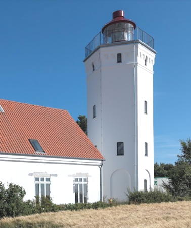
**** Stevns (Stevns Klint) (2)
1878 (station established 1818). Active; focal plane 64 m (210 ft); one long (2 s) white flash every 25 s. 26 m (85 ft) round masonry tower with lantern and gallery; 1st order Fresnel lens in use. Lighthouse painted white; lantern dome is greenish metallic. Erik Cleves Kristensen's 2021 photo is at the top of this page, Wikimedia has several other good photos, Trabas has a photo, Mathieu Uhl has a 2021 photo, Marinas.com has aerial photos, Huelse has an excellent 2008 photo and a historic postcard view, and Google has a street view and a satellite view. In 2009 the light station was transferred to the Nature Agency, which has leased the station to Stevns Kommune. The keepers house is a museum with exhibits on the history of the lighthouse and the nature and geology of the cliff (klint). Stevns Klint is the tip of a peninsula that pokes eastward into the Baltic Sea from the southeastern coast of Sjælland. Located about 5 km (3 mi) east southeast of Stevns. Site and tower open daily (free), museum open on the weekends. Owner: Naturstyrelsen. Site manager: Stevns Kommune (Stevns Fyrcenter). . ARLHS DEN-123; DFL-3250; Admiralty C2094; NGA 5080.

1818 Stevns Klint Light, Stevns, June 2022
Google Maps photo by Toon Hermans

Vordingborg Municipality Lighthouses

The Vordingborg Municipality includes the southern peninsula of Sjælland and the adjacent islands of Bogø and Møn.

Præstø Area Lighthouses
* Præstø Næb
1898. Inactive since 1970. 4 m (13 ft) square wood building, painted white with a red horizontal band. Google has a street view but a tree hides some of the building in Google's satellite view. This light formerly guided ships in the Præstø Fjord; it was abandoned as the town of Præstø grew to surround it. Long missing from lists of Danish lights, it was rediscovered in 2012. Its owner has maintained it in excellent condition. Located at the intersection of the Fasenvej and the Svanevej in Præstø. Site open, building closed. Site manager: private. ex-DFL-4190.
* Roneklint Forfyr (replica)
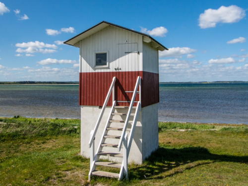
2020 replica of 1894 lighthouse. Inactive. 4 m (13 ft) square wood building; the light was originally displayed through a small square window. Lighthouse painted white with one red horizontal band. The original lighthouse was inactive since about 2006 and destroyed in 2018. Kristina Møller's 2023 photo is at right, Annette Hansen also has a 2023 photo, Anke/Jens have a page for the lighthouse, Huelse has a closeup photo, and Google has a satellite view. The rear lighthouse was replaced by a skeletal tower. These range lights were missing from the 2007 Dansk Fyrliste. The lighthouse was destroyed by fire in December 2018. In June 2019 the Coastal Directorate approved an exemption from regulations to allow the Vordingborg municipality to rebuild the lighthouse, and the rebuilding was completed in July 2020. Camilla Almlund has a photo of the reconstructed lighthouse and Chela Sanchez has a 2021 photo. Located on the beach at Roneklint, just east of the entrance to the Praestø Fjord. Site open, tower closed. . ARLHS DEN-139; ex-Admiralty C2122.

Møn and Bogø Lighthouses
Møn is an island off the southeast coast of Sjælland. The island has a population of about 10,000. It is connected directly to Sjælland by the Queen Alexandrine Bridge; it is also connected to both Sjælland and Falster via Bogø and the Farø Bridges. Bogø, west of Møn, is a smaller island about 7 km (4 mi) in length and having a population of about 1100.

#Hellehavns Nakke
1911. Removed in 2024. 6 m (20 ft) round cast iron tower with lantern, painted with red and white horizontal bands. Bo Jørgensen has a photo, Trabas has a closeup photo, Lemvigh has a page with a photo, Huelse also has a photo plus a historic postcard view, and Google has a satellite view. Nakke is Danish for "neck." In immediate danger of falling over the cliff, the lighthouse was removed and scrapped in January 2024. Located at the northeastern tip of Møn. According to Anke/Jens, the lighthouse was accessible by a walk of about 500 m (0.3 mi) from Liselund Slot, an 1880s "castle" available for overnight accommodations. Site open, tower closed. . ARLHS DEN-141; ex-DFL-5884; ex-Admiralty C2144; NGA 4512.

Roneklint Forfyr, Roneklint, February 2023
Instagram photo by Kristina Møller
Møn
1845. Active; focal plane 25 m (82 ft); four white flashes, separated by 5 s, every 30 s. 13 m (43 ft) octagonal cylindrical brick tower with lantern and gallery, rising from the seaward side of a 1-1/2 story brick keeper's house. 3rd order Fresnel lens, installed in 1947. The lighthouse is unpainted orange brick; lantern and gallery painted white with a red dome. A photo is at right, Trabas has a good photo, Imke Heyder has a photo, Michael Sorms has a 2018 view from the sea, Wikimedia has a view from the sea, Huelse has a photo and a historic postcard view, Ingo Maack has a street view, and Google has a satellite view. According to Lemvigh the lighthouse was restored in 1999 but there is no longer any public access to the station. Located at the end of the Fyrvej on Møn Klint, the eastern tip of Møn. Site and tower closed but there is public parking just outside the gate. . ARLHS DEN-025; DFL-5880; Admiralty C2142; NGA 4508.
Hårbølle Pynt
Date unknown. Inactive. Approx. 7 m (23 ft) square wood tower painted white with black trim. Huelse has a historic postcard view and the small structure is centered in Bing's satellite view. Trabas has a photo of the modern Hårbølle Point Range Front Light. Located on private property off the Hårbøllevejon the southwest coast of Møn. Site and tower closed. Owner/site manager: private.
Borgsted
1898. Active; focal plane 3.5 m (11 ft); white, red, or green light depending on direction, 3 s on, 2 s off. 4 m (13 ft) square wood building; the light is displayed through a rectangular window. Lighthouse painted white with one red horizontal band. Trabas has a good photo, Huelse also has a photo, and Google has a satellite view and a distant street view. This is a directional light for vessels westbound in the Grønsund between Møn and Falster. Located just off the Grønsundvej at the southwestern corner of Møn. Site and tower closed (private property). ARLHS DEN-142; DFL-5685; Admiralty C2178; NGA 4480.

Møn Light, Vordingborg, November 2014
Wikimedia Creative Commons photo by Winbladh
** Bogø
1895. Inactive since 1985. 7 m (23 ft) rectangular 2-story concrete building; the light was shown through a large window on the seaward side. Lighthouse painted white with one red horizontal band. Mogens Bergmann has a 2021 photo, Huelse has a photo and a historic postcard view, and Google has a satellite view. There is a preservation group, Bogø Fyrs Venners, and a 2015 photo by Michael Olesen showed that the lighthouse had been restored and repainted. The lighthouse is available for "primitive" overnight stays. The light marked the western entrance to the Grønsund, here separating Bogø from Falster. Bogø is a smaller island northeast of Falster and west of Møn. Highway 287 runs the length of the island and continues on a bridge to Møn. Located at the end of the Vesternaesvej near the western tip of the island. Site open and tower open. Site manager: Bogø Fyrs Venners . ARLHS DEN-138.

Southern Sjælland Lighthouse
* Ore (2)
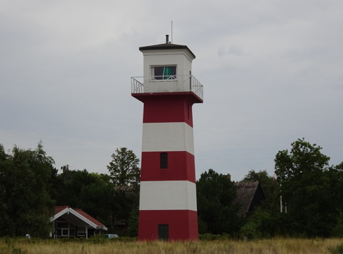
1895 (station established 1879). Active; focal plane 13 m (43 ft); white, red, or green light depending on direction, 2 s on, 2 s off. 13 m (43 ft) rectangular tower with a lantern room and gallery on the top floor. Lighthouse painted with red and white horizontal bands. Heather Craven's photo is at right, Mariann Rasmussen has a 2022 photo, Trabas has a good photo, Anke/Jens have a page on the light, Ejlif Pedersen has a 2018 closeup photo, Huelse has a historic postcard view in which the tower is painted all white, and Google has a satellite view. This light guides ships eastbound into the harbor of Vordingborg, a town at the southern tip of Sjælland opposite Falster. Located on the Søvej near the Badevej, about 1.5 km (1 mi) west of the Vordingborg waterfront. Site open, tower closed. . ARLHS DEN-122; DFL-5370; Admiralty C1798; NGA 4296.

Ore Light, Vordingborg, August 2018
photo copyright Heather Craven; used by permission

Guldborgsund Municipality: Falster Lighthouses

Falster is a substantial island with a population of more than 40,000 located due south of Sjælland. The E47 expressway crosses the island, linking it to Sjælland by the Farø Bridge and to Lolland by the Guldborgsund Tunnel. The Guldborgsund Municipality includes Falster and the eastern third of Lolland.

Falster Lighthouses
* Orehoved Bagfyr (2)
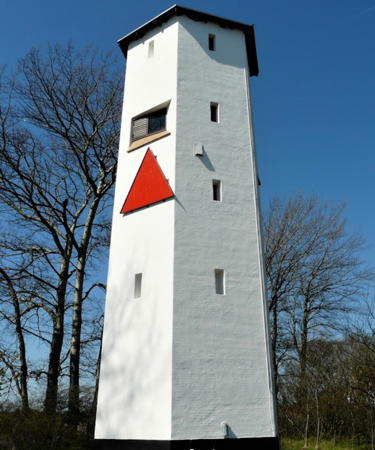
1895 (station established 1879). Active; focal plane 11 m (36 ft); white, red, or green light depending on direction, 2 s on, 2 s off. 11 m (36 ft) semielliptical cylindrical tower with lantern and gallery, painted white. The tower also carries a red triangular daymark. Huelse' has a good 2008 photo, Trabas has a good photo, Anke/Jens have a page, and Google has a satellite view. The lighthouse, which replaced a light on a mast, was raised in height by an additional story in 1933. The front light is on a small post. Located at the northwest corner of the quay in Orehoved, in northwest Falster a short distance west of the Storstrøm Bridge from Vordingborg. Site open, tower closed. ARLHS DEN-135; DFL-5376; Admiralty C1800.1; NGA 4304.
* Stubbekøbing
Date unknown. Active; focal plane 5 m (16 ft); white, red, or green light depending on direction, 2 s on, 2 s off. 4 m (13 ft) square wood building; the light is displayed through a rectangular window. Lighthouse painted white with one red horizontal band. Trabas has a photo, Huelse also has a photo, and Google has a satellite view. This light guides ships into the harbor of Stubbekøbing, on the south side of the Grønsund opposite Bogø. Located on the west side of the village. Site open, tower closed. ARLHS DEN-184; DFL-5650; Admiralty C1856; NGA 4348.
Grønsund Bagfyr
Date unknown. Active; focal plane 20 m (66 ft); white light, 2 s on, 2 s off. 19 m (62 ft) square skeletal tower, painted white and carrying a slatted triangular daymark. Trabas has a photo, Lemvigh has photos, and Google has a street view and a satellite view. Located on the north coast of Falster about 5 km (3 mi) east of Stubbekobing. Site status unknown. DFL-5704a; Admiralty C2166.1; NGA 4476.
* Grønsund Forfyr
1891. Active; focal plane 12 m (39 ft); white light, intensified on the range line, 1 s on, 1 s off. 13 m (43 ft) hexagonal brick tower; the light is shown through a rectangular window. Lighthouse painted white; the tower also carries a triangular red and yellow banded triangular daymark. John Hansen's 2019 closeup photo is at right, Lemvigh has a page for the lighthouse, Trabas has a closeup photo, and Google has a street view and a satellite view. Located on the Gammel Faergevej east of Grønsund, at the northeastern corner of Falster. Site open, tower closed. ARLHS DEN-136; DFL-5704b; Admiralty C2166; NGA 4472.
* Hestehoved
1891. Active; focal plane 14 m (46 ft); white, red, or green light depending on direction, occulting twice every 6 s. 1-story lantern house attached to a 1-1/2 story keeper's house. Lighthouse painted white with gray roofs. Trabas has a closeup photo, Martin Povelsen has a small 2021 photo, Huelse also has a photo as well as a historic postcard view, and Google has a satellite view. This directional light stands on the easternmost point of Falster and marks the entrance to the Grønsund, the sound separating Falster from Møn. Located about 3 km (2 mi) east of Moseby. Site open, tower closed. ARLHS DEN-137; DFL-5860; Admiralty C2152; NGA 4468.


Grønsund Forfyr, Grønsund, April 2019
Google Maps photo by John Hansen

Gedser Odde
1802. Active; focal plane 26 m (85 ft); three white flashes every 15 s. 20 m (66 ft) hexagonal cylindrical stone tower with lantern and gallery. Lighthouse painted white, lantern red. 1-1/2 story keeper's house and other light station buildings. Morten Hinrichsen's 2022 photo is at right, John Nansen has a 2019 photo, Trabas has a good photo, a 2007 photo is available, Anke/Jens have a page for the lighthouse, Huelse has a historic postcard view, Marinas.com has aerial photos, and Google has a street view and a satellite view. This historic lighthouse stands near the southernmost point of Denmark. About 600 m (2000 ft) southeast, at the extreme point of the cape, there was previously a very tall cylindrical radar tower that resembled a lighthouse; that twer collapsed in 2006 and was not replaced. Located on Gedser Odde, the southern tip of Falster, about 3 km (2 mi) southeast of the town of Gedser. Site and tower closed. . ARLHS DEN-010; DFL-5800; Admiralty C2186; NGA 4436.
* Gedser Havn Forfyr
Date unknown. Active; focal plane 17 m (56 ft); white light, 1 s on, 1 s off. 15 m (49 ft) square skeletal tower carrying an orange slatted triangular daymark. Trabas has a photo and Google has a street view and a satellite view. Gedser is the terminal for Scandlines ferries from Rostock, Germany. Located on the east breakwater of Gedser harbor. Accessible by walking the pier. Site open, tower closed. DFL-5816b; Admiralty C2196; NGA 4440.
* Gedser Havn Bagfyr
Date unknown. Active; focal plane 26 m (85 ft); white light, 1 s on, 1 s off. 30 m (98 ft) square skeletal tower carrying an orange slatted triangular daymark. Trabas has a photo and Google has a street view and a satellite view. Located in a ferry parking area 376 m (1/4 mi) north of the front light. Site open, tower closed. DFL-5816a; Admiralty C2196.1; NGA 4444.
Gedser Rev
2003. Active; focal plane 8 m (26 ft); red flash every 5 s. 8 m (26 ft) post light with lantern and gallery, painted red. Huelse also has a photo and Trabas has a very distant view but the light is not shown in Google's satellite view. This light replaced a lightship station; Fyrskib XVII Gedser Rev served this station from 1921 to 1972 and is now moored at the Værftsmuseet in Helsingør. Located on a shoal in the Baltic Sea about 12 km (7.5 mi) southeast of Gedser. Accessible only by boat. Site open, tower closed. DFL-5802; Admiralty C2186.5.
Rødsand Rende
Date unknown. Active; focal plane 13 m (43 ft); three red flashes every 10 s. 14 m (46 ft) post supporting a lantern and gallery. Entire beacon painted red. Fog horn ( three 2 s blasts every 30 s). Trabas has Thomas Quatsling's photo and Bing has a satellite view. Located on a shoal about 2.8 km (1.75 mi) southwest of Gedser Odde. Accessible only by boat. Site open, tower closed. DFL-5804; Admiralty C2188; NGA 4424.

Gedser Odde Light, Guldborgsund, July 2022
Google Maps photo by Morten Hinrichsen

Lolland Muncipality: Lolland and Vejrø Lighthouses

Lolland is Denmark's fourth largest island, located southwest of Sjælland and separated from Falster by a narrow strait called the Guldborgsund. The E47 expressway crosses the island, linking it to Falster by the Guldborgsund Tunnel. On the south, Lolland faces the Fehmarn Belt, a strait crossed by ferries carrying traffic from Rødbyhavn to Fehmarn in Germany. Denmark and Germany plan to build a fixed link across the Belt, which is 18 km (11 mi) wide. Construction began in January 2021 despite much opposition from environmental groups. It's not clear if the link will be completed, but if so the completion won't be before 2029.
Hyllekrog
1905. Inactive since 1991. 18 m (59 ft) square masonry tower with lantern and gallery. Lighthouse painted white, lantern red. The tower was formerly attached to a 1-1/2 story masonry keeper's house. Jan Lillebæk's photo is at right, Piotr Jędraszczyk has a 2023 photo, Brian Thomsen has a 2014 photo, Huelse has a photo and a historic postcard view of the intact station, Marinas.com has aerial photos, and Google has a satellite view. After the light was deactivated in 1991 the optics were transferred to the Christiansø lighthouse in Bornholm and the keeper's house was demolished. The lighthouse was abandoned for two decades. In 2011 it was transferred to the Danish Nature Agency, which repaired and restored the tower. Located near the end of a long sand spit attached to the southernmost tip of Lolland, about 9 km (5.5 mi) southeast of Rødbyhavn. Accessible by 4WD or by boat; however the area is closed for protection of nesting birds between March 1 and July 15. Site open; the tower is unlocked. Owner/site manager: Dansk Naturstyrelsen. . ARLHS DEN-134.
* Albuen (4)
1958 (station established 1779). Inactive since 2014. 13 m (43 ft) round cylindrical concrete tower with lantern and gallery. Lighthouse painted white; lantern dome painted red. Nikolaj Santner has a 2021 photo, Trabas has a closeup by Karl-Heinz Wellm, Huelse has a photo by Kai Thomalla, and Google has a satellite view. This station was established with a post light to guide mail boats. A pair of small range lights was installed in 1884 and then replaced in 1896 by a concrete tower. However, the station stands on a dynamic sandspit, and migration of the spit eventually put the lighthouse in the water; its ruins can be seen in the sound several hundred meters northwest of the present lighthouse. The lighthouse was originally the rear light of a range. Adjacent to the lighthouse is a former one-room schoolhouse, now renovated for vacation rental. Located on a strongly curved spit at the extreme western tip of Lolland, where it marks the southeastern entrance to the Storebælt. Site open, tower closed. . ARLHS DEN-133; ex-DFL-3815; ex-Admiralty C1716.1; ex-NGA 4160.
Vejrø
1846. Active; focal plane 19 m (62 ft); white, red, or green light depending on direction, occulting once every 5 s. 16 m (52 ft) hexagonal cylindrical masonry tower rising from the angle of an L-shaped 1-1/2 story keeper's house. Lighthouse painted white; the house is white with a red tile roof. A 2015 closeup photo is available, Trabas has a closeup by Ina Rendtel, Huelse has a good closeup photo by Bernd Claußen, Marinas.com has aerial photos, and Google has a satellite view. Vejrø is an island in the Smålands Farvandet, the shallow sound between Lolland and Sjælland; it is a privately owned resort. Located at the northeast point of the island. Accessible only by boat. Site open only to resort guests, tower closed. . ARLHS DEN-045; DFL-5210; Admiralty C1732; NGA 4216.

Hyllekrog Light, Lolland, October 2019
Google Maps photo by Jan Lillebæk

Slagelse Municipality (Sjælland West Coast, Storebælt) Lighthouses

The west coast of Sjælland faces the Storebælt (Great Belt), the strait separating Sjælland from Fyn. The Storebælt is the widest of the three outlets of the Baltic Sea, varying in width from 16 to 32 km (10-20 mi). Since 1998 it has been bridged on the E20 expressway by the Great Belt Fixed Link (Storebæltsforbindelsen), which includes one of the world's longest suspension spans.

Omø and Agersø Area Lighthouses
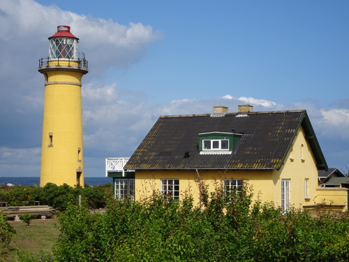
* Langelands Øre (Omø)
1894. Active; focal plane 21 m (69 ft); white, red or green light depending on direction, occulting twice every 12 s. 22 m (72 ft) round brick tower with lantern and gallery. Lighthouse painted yellow, lantern white. 1-1/2 story keeper's house used as a private residence. Ian Yarde's photo is at right, Janus Olsen has a 2021 closeup sunset photo, Huelse has a closeup photo showing the lighthouse freshly repainted a bright yellow, Trabas has a photo by Pauline and Wim de Kleine, Ejaz Yousaf has a sunset photo, Lemvigh has a page with photos, Marinas.com has aerial photos, Huelse also has a historic postcard view, and Google has a street view and a satellite view. Despite its name ("Langeland's Ear"), this lighthouse is not on Langeland but across the Storebælt on the island of Omø. The island is accessible by passenger ferry from Stigsnæs on Sjælland. Located on the western tip of the island. Site open (respect private property). The Anke/Jens site says the tower is open for climbing but other sources say it was closed in 2005. . ARLHS DEN-127; DFL-3694; Admiralty C1640; NGA 4120.
* Helleholm (Agersø) (2)
1900 (station established 1846). Active; focal plane 12 m (39 ft); white, red or green light depending on direction, occulting three times every 15 s. 12 m (39 ft) square cylindrical tower with lantern and gallery. Lighthouse painted white, lantern dome red. Trabas has a closeup, Lemvigh has a page for the lighthouse, Marco Jensen has a 2019 photo, a 2022 photo is available, Marinas.com has aerial photos, Huelse has a 2008 photo and a historic postcard view, Jarl Pettersson has a street view, and Google has a satellite view. Located on Helleholm, the southeastern tip of the island of Agersø, about 3 km (2 mi) northeast of Strignaes. Agersø is accessible by ferry from Strignaes. There's also a good view of this lighthouse from ferries between Strignaes and Omø. Site open, tower closed. . ARLHS DEN-014; DFL-5188; Admiralty C1648; NGA 4092.

Langelands Øre Light, Omø, August 2018
photo copyright Ian Yarde; used by permission
 
Agersø Flak
1977. Active; focal plane 10 m (33 ft); three white flashes every 10 s, white, red or green depending on direction. 10 m (33 ft) round lantern and gallery mounted on a tall mast. Entire lighthouse painted red. Trabas has a photo by Capt. Peter Mosselberger and Google has a satellite view. Located on the east side of the Storebælt channel about 5 km (3 mi) west of the island of Agersø and a similar distance northwest of Omø. Accessible only by boat. Site open, tower closed. DFL-3686; Admiralty C1534.8; NGA 4088.
Vengeancegrund
1977. Active; focal plane 10 m (33 ft); two white flashes every 5 s, white, red or green depending on direction. 10 m (33 ft) round lantern and gallery mounted on a tall mast. Entire lighthouse painted green. Trabas has a photo by Capt. Peter Mosselberger and Google has a satellite view. Located on the west side of the Storebælt channel about 2.7 km (1.7 mi) northwest of the Agersø Flak light. Accessible only by boat. Site open, tower closed. DFL-3680; Admiralty C1534.7; NGA 4084.
Egholm Flak
1977. Active; focal plane 10 m (33 ft); two white flashes every 3 s, red or green depending on direction. 10 m (33 ft) round lantern and gallery mounted on a tall mast. Entire lighthouse painted red. Trabas has a photo by Capt. Peter Mosselberger and Google has a satellite view. Egholm is the northern point of Agersø. Located on the west side of the Storebælt channel about 5 km (3 mi) northwest of Agersø. Accessible only by boat. Site open, tower closed. DFL-3675; Admiralty C1534.6; NGA 4080.

Korsør Area Lighthouses
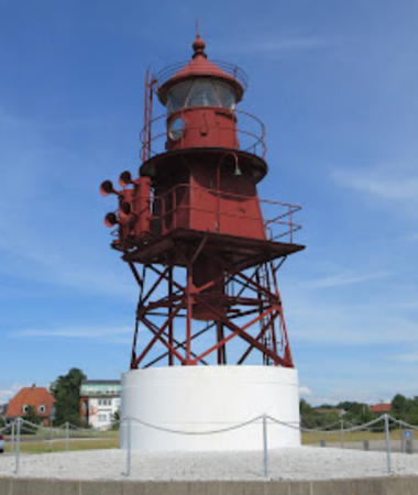
* Korsør (relocated)
1913. Inactive since 1999. Approx. 9 m (30 ft) square pyramidal cast iron skeletal tower with lantern, gallery, and enclosed watch room. Entire lighthouse painted red. Ejlif Pedersen has the 2022 photo at right, Nikolaj Erik Bay Theilgaard has a 2020 photo, Huelse has a 2008 photo, Marinas.com has aerial photos, and Google has a satellite view and a distant street view. This lighthouse formerly stood in the Storebælt guiding the ferries from Nyborg on Fyn. It was built by Danish State Railways and nicknamed Koen ("cow") for the sound of its foghorn. It was deactivated after the completion of the Great Belt Fixed Link, which opened to rail traffic in 1997 and to auto traffic in 1998. A local preservation group then organized to save the lighthouse and it was relocated to a position on the Korsør waterfront. The fog horn is operational and is sounded each year on May 31. Google's October 2010 street view shows the lighthouse wrapped during restoration. Located at the west end of the Gamle Banegårdsplads on the north side of the inner harbor entrance at Korsør. Site open, tower closed. ARLHS DEN-170.

Korsør Light, Korsør, January 2022
Google Maps photo by Ejlif Pedersen
* Korsør (Halsskov, Ferry, Inner) Bagfyr (Havnestenen) (5?)
1997 (?) (station established 1793). Active; focal plane 25 m (82 ft); continuous green light. 23 m (75 ft) square skeletal tower with gallery, carrying a triangular slatted daymark, point down. Daymark painted red. Trabas has a photo and Google has a street view and a satellite view. The original post light was replaced in 1819 by a square brick tower, in 1842 by a round brick tower, and in 1893 by a skeletal tower. Huelse has a postcard view of the 1842 range towers, which were demolished in 1904. The construction of the Great Belt Fixed Link required a change in the range line and thus new towers were required. The front light is on a stainless steel post. Located beside a traffic roundabout on the Tårnborgvej, behind the former ferry pier. Site open, tower closed. ARLHS DEN-172; DFL-3464a; Admiralty C1544.1; NGA 3728.
* Halsskov (4)
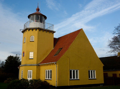
1894. Inactive since 1917. 7 m (23 ft) semicircular masonry tower with lantern and gallery attached to the seaward end of a 1-1/2 story masonry keeper's house. Building painted white with gray trim. Huelse has the 2008 photo at right and Google has a satellite view. The original basket light was replaced in 1810 by a basket on a triangular brick pedestal; Huelse also has a photo of that light, which stands in front of the 1894 lighthouse. The third lighthouse was built in 1856. Located at the end of the Lygtebakken facing the waterfront of Halsskov, on the northwest side of Korsør. Site and tower closed (private residence) but the lighthouse can be viewed from the street. ARLHS DEN-032.
Østerrenden Syd
1992. Active; focal plane 10 m (33 ft); three red flashes every 10 s. 10 m (33 ft) round lantern and gallery mounted on a tall mast. Entire lighthouse painted red. Trabas has a closeup by Capt. Peter Mosselberger and Google has a satellite view. The Østerrenden channel, east of Sprogø, is the main ship channel under the Great Belt Fixed Link. Located just south of the west pylon of the Østbroen (Eastern Bridge), which links Sprogø to Sjælland. Accessible only by boat. Site open, tower closed. DFL-3424; Admiralty C1534; NGA 3692.
 

Halsskov Light, Korsør, 2008
photo copyright Klaus Huelse; used by permission
Østerrenden Nord
1992. Inactive since 2015. 10 m (33 ft) round lantern and gallery mounted on a tall mast. Entire lighthouse painted green. The NGA list includes a listing of a RACON (radar navigation aid) at the deactivated lighthouse. Located on the west side of the Østerrenden channel at its northern end, about 1 km (0.6 mi) northeast of the Sprogø Nordost light. Accessible only by boat. Site open, tower closed. ex-DFL-3396; ex-Admiralty C1532.5; NGA 3682.

Kalundborg and Odsherred Municipalities (Northwest Sjælland) Lighthouses

Kalundborg Municipality Lighthouses
**** Røsnæs
1844 (heightened in 1859). Inactive since 2008; a radio beacon is active. 15 m (49 ft) square cylindrical masonry tower with lantern and gallery, attached to a 1-1/2 story masonry keeper's house. Lighthouse painted white, lantern red. One of the station buildings houses a café. Attila Borbiró's 2023 photo is at right, Lars Jensen has a closeup, Larry Myhre has a photo, Finn Hansen has a 2021 photo, Werning has a distant view, Lemvigh has the history of the station, Mark Torabi has a closeup street view and Google has a satellite view. The lighthouse stands on the westernmost point of Sjælland, at the end of a long, narrow peninsula that protects the north side of the Kalundborg Fjord. After deactivation it was transferred to the Naturstyrelsen (Nature Agency). Located at the end of the road, near Hellesklint and about 15 km (9 mi) west of Kalundborg. Site open, tower and café open daily April through mid October. Owner/site manager: Naturstyrelsen (Rosnæs Fyr ). ARLHS DEN-034; ex-DFL-2025; ex-Admiralty C1496; ex-NGA 3588.
Røsnæs Puller
1939. Active; focal plane 9 m (30 ft); two white flashes every 5 s. 9.5 m (31 ft) skeletal mast mounted on a round granite base, all standing on a round pier. Originally this was an approximately 18 m (59 ft) round 2-stage tower with lantern and gallery, upper stage cast iron and lower stage granite. Sometime after 2000 all of this lighthouse was removed except for the granite lower stage. Kurt Kehler has a 2023 photo, Andreas Köhler has a 2021 photo, Trabas has a photo by Capt. Peter Mosselberger, and Huelse also has a photo, but the light is not shown in Google's satellite view. Located on a shoal about 2 km (1.2 mi) west of the Røsnæs lighthouse. Accessible only by boat. Site open, tower closed. DFL-2020; Admiralty C1498; NGA 3592.
* Sejerø
1852. Active; focal plane 31 m (102 ft); two white flashes every 15 s. 19 m (62 ft) round masonry tower with lantern and gallery. The lighthouse is painted a pale yellow; the lantern is gray metallic. A 1-1/2 story keeper's house is nearby. Trabas has a closeup by Karl-Heinz Wellm, Rüdiger Kroll has a 2021 photo, Torsten Jantsch has a 2022 closeup, Lemvigh has a page for the lighthouse, Huelse has a closeup by Bernd Claußen and a historic postcard view, Poul Larsen has a street view, and Google has a satellite view. Sejerø is a sandy island in the Kattegat about 8 km (5 mi) west of Ordrup Naes; the island has about 400 inhabitants. Ferry transportation to the island is available from Havnsø. Located atop a dune at the western tip of the island. Site open, tower closed. . ARLHS DEN-125; DFL-1975; Admiralty C1486; NGA 3556.
 

Røsnæs Light, Kalundborg, March 2023
Google Maps photo by Attila Borbiró

Odsherred Municipality Lighthouses
Sjællands Rev Nord
1971. Active; focal plane 26 m (85 ft); white, red or green light depending on direction, 1 s on, 1 s off. 26 m (85 ft) round cylindrical tower with lantern, gallery, and a helipad atop the lantern. Lighthouse painted white with one red horizontal band. Trabas has a photo by Capt. Theo Hinrichs but the lighthouse is not shown in Google's satellite view. The lighthouse was restored in 2017. Located on a submerged rocky reef (rev) in the Kattegat about 6 km (3.5 mi) northwest of the tip of the Sjællands Odde spit. Accessible only by boat. Site open, tower closed. ARLHS DEN-037; DFL-1920; Admiralty C1478; NGA 2036.
Yderflak
Date unknown. Active; focal plane 10 m (33 ft); green flash every 3 s. 10 m (33 ft) lantern and gallery on a post. Entire structure is green. Trabas has Capt. Peter Mosselberger's distant view but the light is not shown in Google's satellite view. Located off the Sjællands Odde spit about 2.5 km (1.5 mi) south of the Sjællands Rev Nord lighthouse. Accessible only by boat. Site open, tower closed. DFL-1910; Admiralty C1480; NGA 3528.
Sjællands Rev
Date unknown. Active; focal plane 6 m (20 ft); white flash every 5 s. 6 m (20 ft), red lantern mounted on a pier. Trabas has Capt. Peter Mosselberger's distant view but the light is not shown in Google's satellite view. Located off the Sjællands Odde spit about 3.5 km (2.25 mi) south southeast of the Sjællands Rev Nord lighthouse. Accessible only by boat. Site open, tower closed. DFL-1925; Admiralty C1476; NGA 3524.

Information available on lost lighthouses:

Notable faux lighthouses:

Adjoining pages: North: Copenhagen | East: Bornholm | South: Lübeck to Flensburg | West: Fyn

Return to the Lighthouse Directory index | Ratings key

Posted February 1, 2007. Checked and revised April 18, 2024. Lighthouses: 40. Site copyright 2024 Russ Rowlett and the University of North Carolina at Chapel Hill.