Lighthouses of Germany: Vorpommern-Greifswald

The Federal Republic of Germany (Bundesrepublik Deutschland in German) occupies a central location in northern Europe with two coastlines, one facing northwest on the North Sea and the other facing northeast on the Baltic Sea. The country's history is long and complex. The large number of historically independent German regions came together in 1871 to form the German Empire. The Empire became a republic after World War I (1914-18). After World War II (1939-45) Germany was divided into two countries, the German Federal Republic in the west, usually called West Germany, and the Communist-led German Democratic Republic in the east, usually called East Germany. After the Communist government collapsed the Federal Republic reunified the nation in October 1990.

Germany is a federation of 16 member states called Bundesländer, and the states are divided into districts (Kreise). This page lists lighthouses of the district of Vorpommern-Greifswald, part of the state of Mecklenburg-Vorpommern. Before the creation of the German Empire in 1871 all of this region was part of the Kingdom of Prussia. From the end of World War II until the reunification of Germany in 1991 it was part of the German Democratic Republic (East Germany). Mecklenburg includes the western portion of the former East German coast (the Wismar, Warnemünde, and Rostock areas), while Vorpommern (Lower or Western Pomerania) includes the eastern section from the Stralsund area to the Polish border. Vorpommern-Greifswald is the easternmost district of the state.

Interest in lighthouses is strong in Germany and most of the towers are in good condition. A federal law provides blanket protection to historic lighthouses. There is concern, however, that many of the lights may be deactivated in the coming years as navigators depend less and less on them.

In German, a lighthouse is a Leuchtturm ("light tower"), plural Leuchttürme. The front light of a range is the Unterfeuer and the rear light is the Oberfeuer. Modern range lighthouses are crowned by a topmark: a large, distinctive structure that serves to mark the range clearly in the daytime. In German Insel is an island, Riff is a reef, Kap is a cape, Bucht is a bay, and Hafen is a harbor. The Baltic Sea is known in Germany as the Ostsee (East Sea).

Lighthouses in Germany are operated by the regional harbor authority, called the WSA (Wasserstraßen- und Schifffahrtsamt). Recently the two WSA's for the Baltic coast, WSA Lübeck and WSA Stralsund, have been merged to form the WSA Ostsee. The WSA's are linked to and regulated by a federal agency, the Wasserstraßen- und Schifffahrtsverwaltung des Bundes (WSV).

ARLHS numbers are from the ARLHS World List of Lights. Admiralty numbers are from volume C of the Admiralty List of Lights & Fog Signals. U.S. NGA List numbers are from NGA Publication 116.
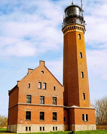

Greifswalder Oie Light, Greifswalder Oie, April 2024
Instagram photo by Jule Koops
General Sources
Online List of Lights - Germany - Baltic Sea East
Photos of German Baltic Sea lights posted by Alexander Trabas.
Leuchttürme und Leuchtfeuer an der Ostsee
Photos and information posted by Erich Hartmann, a contributor to the Online List of Lights.
Leuchtturm-Atlas
A large site with excellent photos and information on nearly all German lighthouses, maintained by Frank and Birgit Toussaint.
Leuchttürme.net - Deutschland
Outstanding photos by Malte Werning.
Leuchtturmseiten von Anke und Jens - Germany Baltic Sea
This site has photos and information on many of the lights.
Germany Lighthouses
Photos by Larry Myhre.
Lighthouses in Mecklenburg-Vorpommern
Photos by various photographers available from Wikimedia.
World of Lighthouses - Germany
Photos by various photographers available from Lightphotos.net.
Lighthouses in Germany
Aerial photos posted by Marinas.com.
Deutsche Leuchttürme/Feuerschiffe
Photos posted by Klause Huelse, who also has a page of historic postcard views.
Interessengemeinschaft Seezeichen e.V.
Germany's national lighthouse preservation organization.
GPSNauticalCharts
Navigation chart for Germany's Baltic coast.
Navionics Charts
Navigation chart for Germany's Baltic coast.


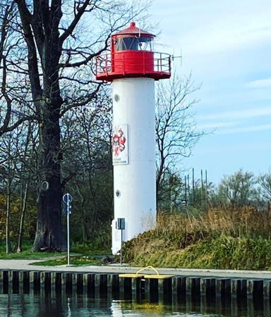
Ueckermünde Light, Ueckermünde, November 2021
Instagram photo by Katrin Lück

Greifswald Lighthouse
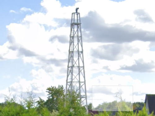
* Eldena (Oberfeuer)
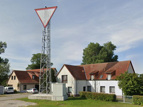
Date unknown. Active; focal plane 22 m (72 ft); white, red, or green light depending on direction, occulting twice every 10 s. 19 m (62 ft) square skeletal tower, painted white. The tower also carries a diamond-shaped daymark, painted white with a red border. Google has the distant 2022 street view seen at right, Trabas has Eckhard Meyer's photo, and the light is centered in a Google satellite view. This light was formerly the rear light of a range, but it has been converted to a directional light. It guides vessels entering the Ryck estuary from Greifswald Bay (Greifswalder Bodden). Located in a residential neighborhood on the east side of Greifswald. Site and tower closed (private property), but the light can be seen from nearby streets. DE 221300; Admiralty C2655.2; NGA 6004.

Greifswalder Oie Lighthouses
Greifswalder Oie is an island of about 54 ha (120 acres) in the Pommerschen Bucht (Pomeranian Bay), about 10 km (6 mi) east of Rügen and 12 km (7.5 mi) north of Usedom. (The unusual-looking word Oie is the Low German word for an island, corresponding to the Swedish ö and Danish ø.)

Greifswalder Oie Leitfeuer (3)
2000 (station established 1962). Active; focal plane 14 m (46 ft); white, red or green light depending on direction occulting once every 6 s. 4 m (13 ft) square white metal cabinet. Trabas has Helmut Seger's photo and Google has a satellite view. Located at the island's harbor. Site open, tower closed. DE 219481; Admiralty C2664.
Greifswalder Oie (1)
1832. Inactive since 1855. Approx. 12 m (40 ft) octagonal pyramidal red brick tower; lantern replaced by a square cap. The Anke/Jens site has a great closeup photo, and Google has a satellite view. Located near the 1855 lighthouse. Site open, tower closed.

Eldena Light, Greifswald, July 2022
Google Maps street view
Greifswalder Oie (2)
1855 (station established 1832). Active; focal plane 49 m (161 ft); white flash every 3.8 s. 39 m (128 ft) octagonal brick tower with lantern and double gallery rising from a square 1-story base. Tower is unpainted red brick, lantern and galleries painted black. A magnificent 3-faceted 1st order Fresnel lens (1913) is in use. 2-1/2 story square brick keeper's house. A 2024 photo by Jule Koops is at the top of this page, Werning has a very good page for the lighthouse, Huelse has a great photo, Trabas has a photo by Klaus Potschien, Bärbel Huster-Timm has a 2022 photo, B.F. Fertig has a 2014 photo, Hennicken Dorfer has a 2021 photo, and Google has a satellite view of the station. A beautiful but rarely visited light station, this is the traditional landfall light for ships approaching Stralsund from the northeast. From 1937 to 1945 the island was a launch site for the German missile development program; A4 and A5 rockets were tested here. The East German government continued the use of the island as a military base. The tiny island, a critical nesting and stopover site for birds, is now a nature preserve (Naturschutzgebiet Greifswalder Oie) managed by the Verein Jordsand, the German equivalent of the Audubon Society in the U.S. Visits to the island require a permit from the Verein or participation in one of the association's activities. The lighthouse is located at the northeastern corner of the island, 1.4 km (0.9 m) from the protected harbor at the other southwestern end. Accessible only by boat and hiking the length of the island, about 1.6 km (1 mi). Site open, tower closed. Operator: WSA Ostsee. Site manager: Verein Jordsand. . ARLHS FED-006; DE 219470; Admiralty C2662; NGA 5940.

Ruden Area Lighthouses
Ruden is a small island on the south side of the entrance to Greifswald Bay, just off the town of Peenemünde.

Neptungrund
1972. Active; focal plane 10 m (33 ft); two very-quick flashing white lights, one on either side of the structure. 10 m (33 ft) round concrete caisson carrying two antenna masts. Trabas has Hartmann's photo and Bing has a satellite view. This structure was built by the East German government as part of its air traffic control for the Peenemünde air force base. The former base is now a civilian airport and the structure is not in use for its original purpose. It's navigational purpose is marking the east side of an extensive shoal. Located about 4 km (2.5 mi) southwest of Ruden island. Accessible only by boat. Site open, tower closed. Admiralty C2658.8.
Tonnenbank
1972. Active; focal plane 10 m (33 ft); two very-quick flashing white lights, one on either side of the structure. 10 m (33 ft) round concrete caisson carrying two antenna masts. Trabas has Hartmann's photo, another photo is available, and Google has a satellite view. This structure was built by the East German government as part of its air traffic control for the Peenemünde air force base. The former base is now a civilian airport and the structure is not in use for its original purpose. Located in the water 1 km (0.6 mi) northwest of the airport. Accessible only by boat. Site open, tower closed. Admiralty C2659.03.
Ruden Nord
1954. Active; focal plane 25 m (82 ft); white, red, or green light, depending on direction, occulting once every 6 s. 23 m (75 ft) square skeletal tower with gallery. Tower painted white; NGA lists a red lantern but there is no lantern shown in Trabas's photo by Helmut Seger. Google has a satellite view. The light guides vessels on a due-east reach across Greifswald Bay. Located at the north end of the island of Ruden about 2.5 km (1.5 mi) north of the Peenemünde airport. Accessible only by boat. Site status unknown. Operator:WSA Ostsee. DE 220240; Admiralty C2656.6; NGA 5944.
Ruden Unterfeuer
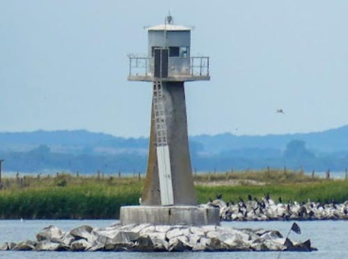
1954. Active; focal plane 8 m (26 ft); white light occulting once every 6 s. 9 m (30 ft) round tapered gray concrete tower with lantern and gallery, unpainted. Peter Wilhelm has the 2022 photo seen at right, Trabas has Werner Seiler's photo, Hartmann has a page for the range, Werning has a page for the lighthouse, and Google has a satellite view. The range guides vessels southwest toward Ruden and Peenemünde. Located off the east side of the low island of Ruden, about 6 km north of the mainland near Peenemünde. Accessible only by boat. Site and tower closed. Operator: WSA Ostsee. ARLHS FED-312; DE 219800; Admiralty C2657.9; NGA 5956.
Ruden Oberfeuer (2)
2014 (station eastablished 1954. Active; focal plane 16 m (52 ft); white light occulting once every 6 s. 15 m (49 ft) steel post carrying a hexagonal lantern. The lighthouse is white with a red balnd at the base and a small black band near the top. Trabas has Hartmann's photo and Google has a satellite view. The light replaced a skeletal tower also seen on Hartmann's page. Located near the south end of Ruden, about 700 m (0.44 mi) west southwest of the front light. Accessible only by boat. Site open, tower closed. Operator: WSA Ostsee. ARLHS FED-313; DE 219801; Admiralty C2658.1 NGA 5960.

Ruden Unterfeuer, Peenemünde, July 2022
Google Maps photo by Peter Wilhelm
Peenemünde
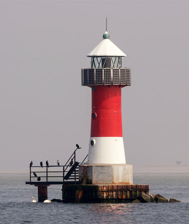
1954. Active; focal plane 12 m (39 ft); white, red, or green light, depending on direction, occulting once every 6 s. 11 m (33 ft) round concrete tower with lantern and gallery. Lighthouse painted red with a white horizontal band at the base; lantern roof is also white. A photo is at right, Werning's page has a photo, Trabas also has a good closeup by Helmut Seger, a 2021 photo is available, and Google has a satellite view. This lighthouse carries two directional lights, one aimed north northeast and the other west northwest. Located about 4 km (2.5 mi) offshore north of Peenemünde and southeast of the Ruden Unterfeuer. Accessible only by boat. Site and tower closed. Operator: WSA Ostsee. . ARLHS FED-189; DE 220100; Admiralty C2659; NGA 5968.

Peenemünde, Peenestrom and Usedom Lighthouses
Usedom is a long island along the south shore of the Baltic Sea; the island extends eastward across the international border into Poland. The town of Peenemünde is at the west end of Usedom. The Peenestrom is the strait separating Usedom from the mainland. The narrow strait leads southeast from Peenemünde to the Stettiner Haff (also called the Oderhaff in Germany and the Szczecin Lagoon in Poland), a large lagoon on the south side of Usedom. A large number of range lights guide navigation on the Pennestrom; only the larger towers are described here.

*
Zinnowitz
2006. Active; focal plane about 14 m (46 ft); yellow flash every 4 s. 14 m (46 ft) post carrying a large round diving bell (Tauchgondol) that can be lowered on the post. Trabas has Eckhard Meyer's photo, Bernd Fechner has a 2016 photo, and Google has a pier view and a satellite view. The diving bell is a tourist attraction, one of several such attractions on Germany's Baltic coast. Located near the end of the pier at Zinnowitz, a resort town about 15 km (9 mi) southeast of Peenemünde. Site and diving bell open. DE 224800; Admiralty C2666.
Tonnenbank Oberfeuer
Date unknown. Active; focal plane 25 m (82 ft); red light occulting once every 6 s. Approx. 13 m (46 ft) square white skeletal tower carrying a large diamond-shaped red slatted daymark. Trabas has Eckhard Meyer's photo and Google has a satellite view. This is the approach range from the north to Peenemünde. The front light is on a much shorter tower. Located at the edge of the forest behind Freest, a town on the west side of the entrance to the Peenestrom. Site status unknown. DE 222541; Admiralty C2659.06.

Peenemünde Light, Peenemünde, May 2019
Wikimedia Creative Commons photo by Unokorno
* Knaakrücken Rinne Unterfeuer
Date unknown. Active; focal plane 16 m (52 ft); white light, 4 s on, 4 s off. 15 m (49 ft) square skeletal tower carrying a triangular daymark, point up. Trabas has a photo and Google has a satellite view. Located on the east side of the Peenemünde yacht harbor. Site appears open, tower closed. DE 222500; Admiralty C2659.1.
* Knaakrücken Rinne Oberfeuer
Date unknown. Active; focal plane 33 m (108 ft); white light, 4 s on, 4 s off. 31 m (102 ft) square cylindrical skeletal tower carrying a triangular daymark, point down. Trabas has Eckhard Meyer's photo and Google has a satellite view. This is the approach range from the northwest to Peenemünde. Located on the Flughafenring in Peenemünde. Site appears open, tower closed. DE 222501; Admiralty C2659.11.
* Peenemünde Sud
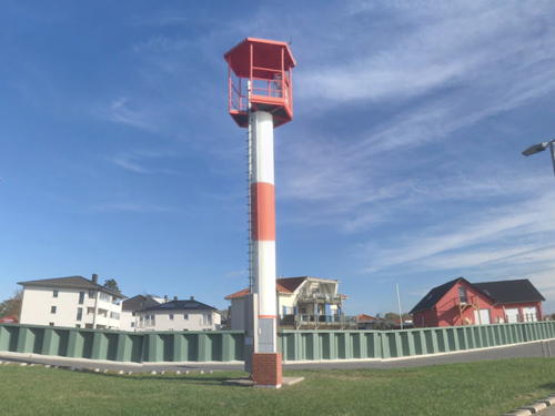
2012. Active; focal plane 12 m (39 ft); white, red or green light depending on direction occulting once every 6 s. Approx. 10 m (33 ft) robust steel mast carrying a hexagonal lantern. Lighthouse painted with red and white horizontal bands. A photo is at right, Trabas has Hartmann's photo, and Google has the street view seen at right and a satellite view. This leading light guides vessels approaching Peenemünde northbound in the Pennestrom. Located on the waterfront of Peenemünde. Site open, tower closed. DE 222900; Admiralty C2659.13; NGA 5969.
Hollendorfer Rack Unterfeuer
2004. Active; focal plane 16 m (52 ft); white light occulting four times every 15 s. 16 m (52 ft) square white skeletal tower carrying a triangular daymark, point up. Trabas has a photo and Google has a satellite view. This range guides eastbound vessels. Located in a field southwest of Karlshagen. Site status unknown. DE 223220; Admiralty C2659.46.
Hollendorfer Rack Oberfeuer
2004. Active; focal plane 20 m (66 ft); white light occulting four times every 15 s. Approx. 19 m (62 ft) square white skeletal tower carrying a triangular daymark, point down. Trabas has a photo and Google has a satellite view. Located in a field southwest of Karlshagen. Site status unknown. DE 223221; Admiralty C2659.47.
Rankwitz Nord Oberfeuer
Date unknown. Active; focal plane 15 m (49 ft); white light occulting once every 6 s. 15 m (49 ft) square skeletal tower carrying a tringular daymark, point down. Trabas has Eckhard Meyer's photo and Google has a satellite view. The front light is on an 8 m (26 ft) skeletal tower. Located off the Peeneweg in the village of Rankwitz. Site open, tower closed. DE 223881; Admiralty C2659.91.
 

Peenemünde Sud Light, Peenemünde, October 2019
Google Maps street view by Richard
Rankwitz-Krienke Oberfeuer
1955. Active; focal plane 27 m (89 ft); two white lights: one occulting four times every 15 s for the southbound Rankwitz range and one occulting twice every 10 s for the north bound Krienke range. Approx. 25 m (82 ft) square skeletal tower, painted white with a red horizontal band. The tower also carries two diamond-shaped daymarks, painted white with red borders, one for each range. Trabas has a photo and Google has a satellite view. The Rankwitz and Krienke front lights are on much shorter towers. Located in a farm field on the west side of Usedom, about 3 km (2 mi) south of Rankwitz. Site and tower closed but the light can be seen from the road. DE 223861 (Rankwitz) and 223862 (Krienke); Admiralty C2659.87.
* Zecherin Oberfeuer
Date unknown. Active; focal plane 23 m (75 ft); white light occulting three times every 15 s. 21 m (69 ft) square skeletal tower carrying a large triangular daymark, point down. Daymark painted white with a red border. Google Maps has the 2022 street view seen at right, Trabas has a photo, Piotr Deresiński has another photo, Marko Hanke has a street view, and Google has a satellite view. This range guides southbound vessels approaching the narrowest passage of the Peenestrom. The front light is on a small skeletal mast. Located on the grounds of a restaurant and guesthouse beside the east end of the Zecheriner Bridge, which connects the mainland to Usedom at the southwestern corner of the island. Site open, tower closed. Site manager: Peene-Idyll. DE 223941; Admiralty C2659.98.
Jahnkenort Oberfeuer
Date unknown. Active; focal plane 17 m (56 ft); white light occulting twice every 10 s. Approx. 16 m (52 ft) square skeletal tower carrying a large triangular daymark, point down. Daymark painted white with a black border. Trabas has a photo and Google has a satellite view. The range guides southbound vessels after they pass the Zecheriner Bridge. The front light is on a much shorter tower. Located in a farm field west of Anklamer. Site status unknown. DE 224041; Admiralty C2660.08.

Zecherin Oberfeuer, Usedom, August 2022
Google Maps street view
* Anklamer West Oberfeuer
1955. Inactive since 2021. Approx. 16 m (52 ft) square skeletal tower carrying a large triangular daymark, point down. Daymark painted white with a black border. Trabas has a photo and Google has a satellite view. The range guided northbound vessels after they enter the Peenestrom. The front light was on a similar but shorter tower. Located beside the Anklamer Fähre (Anklamer Ferry) road. Site open, tower closed. ex-DE 224101; ex-Admiralty C2660.15.

Stettiner Haff (Oderhaff) Lighthouses
The Stettiner Haff (or Oderhaff) is a large lagoon at the mouth of the Oder River, which forms the border between Germany and Poland. Only the western third of the lagoon lies in Germany. In Polish the lagoon is called the Zalew Szczecinski.

*
Kamp-Karnin Oberfeuer (2)
2009 (station established 1965). Active; focal plane 25 m (82 ft); white light occulting three times every 15 s. Approx. 20 m (66 ft) robust square steel mast painted white. Hartmann has a page on the range, Trabas has Hartmann's photo, and Google has a satellite view. This light replaced a 24 m (79 ft) square skeletal tower with a square lantern and gallery, painted white with a red lantern roof. Leuchtturm-Atlas has a photo of the former tower and Hartmann has a 1979 photo on his page. This range guides vessels leaving the Oderhaff for the Peenestrom channel, which leads around the western end of Usedom. Located in a field at the extreme western end of the Oderhaff, on the south side of the Strom entrance. Site open, tower closed. Operator: WSA Ostsee. Active light: DE 224201; Admiralty C2867.1; NGA 6492.
* Ueckermünde Westmole (4)
2000 (station established 1844). Active; focal plane 11 m (36 ft); white light occulting once every 6 s. 11 m (36 ft) round cylindrical fiberglass tower with lantern and gallery. Tower is white, lantern and gallery red; the arms of the city of Ueckermünde are displayed on the front of the tower. Katrin Lück's 2021 photo is at the top of this page, Mathias Fechner has a good 2009 photo, Wikimedia has a 2020 photo, the Anke/Jens site has excellent photos, Trabas has a good closeup by Helmut Seger, Hartmann has a page for the lighthouse, and Google has a street view and a satellite view. This light marks the entrance to the River Uecker at Ueckermünde on the southwest shore of the Oderhaff. Michel Forand has a 1916 postcard view of the second lighthouse and a much later postcard view of the third lighthouse, a skeletal tower built in 1925. Hartmann has a historic photo of the third lighthouse. WSA Stralsund saved the shell of the lantern of the third light and it is installed now behind the headquarters of WSA Ostsee at the end of Wamper Weg in Stralsund; in Google's satellite view the lantern is at the edge of the trees behind the building. Site open, tower closed. Operator: WSA Ostsee. ARLHS FED-244; DE 224360; Admiralty C2860; NGA 6484.

Lighthouse Relocated Inland

Fürstenwalde Lighthouse
Vierendehlgrund (relocated from Barhöft)
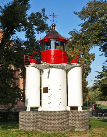
1910 (Julius Pintsch). Inactive since 1982. 13 m (43 ft) round cylindrical cast iron tower with lantern and gallery, originally mounted on a concrete pier. Lighthouse painted white, lantern red. This is the front tower of a pair of range lights at Barhöft abandoned by the East German government when a shift in the channel made them obsolete. The rusting lighthouse became a roosting and nesting site for seabirds. The Leuchtturm Atlas site has a distant photo of the lighthouse on its original station and Werning also has a distant view. In 2006 the lighthouse was removed, leaving only the stone base. After restoration, it was reassembled at the city museum in Fürstenwalde, southeast of Berlin. Thus the lighthouse returned home: Fürstenwalde is where it had been prefabricated by the firm of Julius Pintsch. The reconstruction was completed in June 2007. Peter Dargatz has the closeup photo of the relocated lighthouse seen at right, Hartmann has a page for the lighthouse, Wolfgang Peth has a closeup street view, and Google has an indistinct satellite view. Located on the Domplatz in Fürstenwalde. Site open, museum open daily except Mondays, tower closed. Owner/site manager: Städtisches Museum Fürstenwalde. ARLHS FED-246; ex-Admiralty C2572.

Information available on lost lighthouses:

Notable faux lighthouses:


Vierendehlgrund Light, Fürstenwalde, September 2008
ex-Panoramio Creative Commons photo by Peter Dargatz

Adjoining pages: North: Denmark: Sjælland Region | East: Poland: Świnoujście Area | West: Vorpommern-Rügen

Return to the Lighthouse Directory index | Ratings key

Posted April 9, 2005. Checked and revised June 1, 2024. Lighthouses: 25; lightships: 1. Site copyright 2024 Russ Rowlett and the University of North Carolina at Chapel Hill.