Lighthouses of Western Algeria

The People's Democratic Republic of Algeria (al-dzāyīr in Algerian Arabic) is a North African country with a 1280 km (800 mi) long coastline on the southwestern shore of the Mediterranean Sea opposite France and Spain. French troops captured the city of Algiers in 1830 and subdued the country gradually over several decades of fighting. The country remained a French colony through World War II. A bitter struggle in the 1950s led to independence in 1962.

Algeria is divided into 58 provinces. This page describes lighthouses in the six provinces west of the the Algiers area. There are separate pages for lighthouses of Central Algeria and Eastern Algeria. Oran is the major port of western Algeria and the second largest city in the country.

Arabic is an official language of Algeria and most residents speak a variety of Arabic called Darja. French is widely used in government and media and more than half of the population also speaks French. The Arabic word for a lighthouse is mnarh or manara (منارة). Ra's is a cape, jaza'ir or jazirat is an island, shi'b is a reef, shira' is a bay, and marfa is a harbor. In French phare is the word for a lighthouse, île is an island, cap is a cape, pointe is a promontory or point of land, roche is a rock, récife is a reef, baie is a bay, estuaire is an estuary or inlet, détroit is a strait, rivière is a river, and havre is a harbor.

Aids to navigation in Algeria are operated by the Office National de Signalisation Maritime (ONSM). Most of the historic French lighthouses are being maintained and most still have resident keepers.

ARLHS numbers are from the ARLHS World List of Lights. Admiralty numbers are from volume E of the Admiralty List of Lights & Fog Signals. U.S. NGA List numbers are from Publication 113.

General Sources
Phares et Feux de Jalonnement
Lighthouse information posted by ONSM; photos of the major lighthouse are included.
Online List of Lights -Algeria
Photos by various photographers posted by Alexander Trabas.
World of Lighthouses - Algeria
Photos by various photographers posted by Lightphotos.net.
Phares d'Afrique
Photos of African lighthouses posted by Alain Guyomard and Robert Carceller on the Phares du Monde web site.
Lighthouses in Algeria
Photos by various photographers available from Wikimedia.
Afrikanische Leuchttürme auf historischen Postkarten
Historic postcard images posted by Klaus Huelse.
GPSNauticalCharts
Navigational chart information for Algeria.
Navionics Charts
Navigational chart for Algeria.


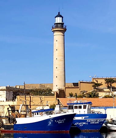
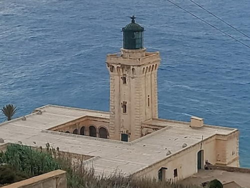
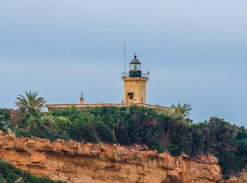
Cherchell Light, Cherchell, October 2020
Wikimedia Creative Commons photo by A. Nasser Hakem
Tlemcen Province (Marsa Ben M'hidi and Ghazaouet) Lighthouses
Ghazaouet (called Nemours in colonial times) is a port town of about 35,000 about 25 km (15 mi) east of the Moroccan border.
* Marsa Ben M'hidi Jetty (West Breakwater)
Date unknown. Active; focal plane 12 m (39 ft); two green flashes every 4 s. 8 m (26 ft) round concrete tower with lantern and gallery, painted white with a green top. Ali Mehadji has a 2018 photo (this light on the left), a 2021 photo is available, Boubakeur Rouichi has a 2021 distant view, Wikimedia has Habib Kaki's distant view and Google has a satellite view. Located on the main breakwater of the marina at Marsa Ben M'hidi, a new resort just east of the Moroccan border. Site open, tower closed. Admiralty E6740.
Marsa Ben M'hidi Inner (East) Breakwater
Date unknown. Active; focal plane 12 m (39 ft); two red flashes every 4 s. 8 m (26 ft) round concrete tower with lantern and gallery, painted white with a red top. Ali Mehadji has a 2018 photo (this light on the right), a 2021 photo is available, and Google has a satellite view. Located on the inner breakwater of the marina at Marsa Ben M'hidi. Site status unknown. Admiralty E6742.
* Ghazaouet (Nemours)
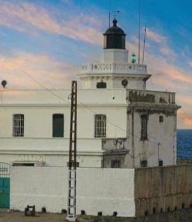
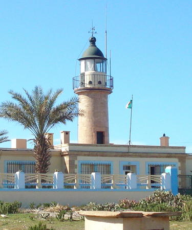
1868. Active; focal plane 92 m (302 ft); three white flashes every 15 s. 15 m (49 ft) round cylindrical tower rising from the center of a 1-story keeper's house. Entire building painted white. A n ONSM photo is at right, Forand has a historic postcard view, and Google has a satellite view. This is the landfall light for Ghazaouet. Located atop a steep hill at the southwestern corner of the harbor. Site open, tower closed. ARLHS ALG-038; Admiralty E6720; NGA 22700.
Rocher des Deux Frères
Date unknown. Active; focal plane 26 m (85 ft) (?); two green flashes every 6 s. 6 m (20 ft) black post mounted on a square base. Base painted white, lantern black. Yassine Marcimini has a 2021 photo, another 2021 photo and a more distant view are available, A. Benmansour has a street view, and Google has a satellite view. The Rocher des Deux Frères (Two Brothers Rock) is a giant split rock sitting right in the entrance to Ghazaouet harbor, no more than 200 meters (220 yd) south of the north jetty light. Accessible only by boat, and landing must be quite a feat. Site and tower closed. ARLHS ALG-054; Admiralty E6732; NGA 22704.
Ghazaouet Môle E
Date unknown. Active; focal plane 8 m (26 ft); continuous green light. 6 m (20 ft) post centered on a round 1-story concrete base. Post painted black. Djamel Lialaoui has a photo and Google has a satellite view. Located at the end of the west pier in Ghazaouet harbor. Site status unknown. Admiralty E6726; NGA 22716.
Ghazaouet Môle D
Date unknown. Active; focal plane 8 m (26 ft); continuous (?) green light. 6 m (20 ft) post centered on a round 1-story concrete base. Post painted black. Djamel Lialaoui has a photo and Google has a satellite view. Located at the end of the east pier in Ghazaouet harbor. Site status unknown. Admiralty E6724.

Ghazaouet Light, Ghazaouet
Office National de Signalisation Maritime photo
* Ghazaouet Jetée Nord Spur
Date unknown. Active; focal plane 8 m (26 ft); continuous red light. 6 m (20 ft) post centered on a round 1-story concrete base. Post painted red. Aimed Chaieb has a closeup (note the Rocher des Deux Frères at the right in this photo), A. Benmansour has a street view, and Google has a satellite view. This light and the preceding light frame the entrance to the inner harbor. Located on a spur of the main breakwater of Ghazaouet harbor. Accessible by walking the pier. Site open, tower closed. Admiralty E6722.2; NGA 22712.
* Ghazaouet Jetée Nord
Date unknown. Active; focal plane 17 m (56 ft); red light occulting once every 4 s. 15 m (49 ft) post mounted on a round cylindrical concrete equipment room. Base painted white, post red. A. Benmansour has a street view, Maarouf Beider has a sunset photo, and Google has a satellite view. Located at the end of the breakwater at Ghazaouet. Accessible by walking the pier. Site open, tower closed. ARLHS ALG-037; Admiralty E6722; NGA 22708.

Aïn Témouchent Province Lighthouses
Île Rachgoun (Béni Saf)
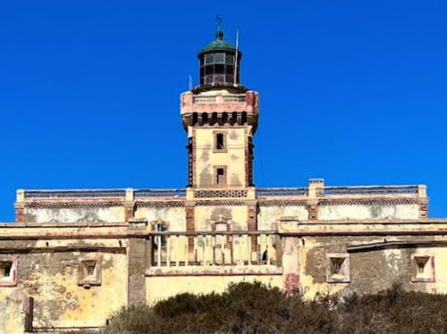
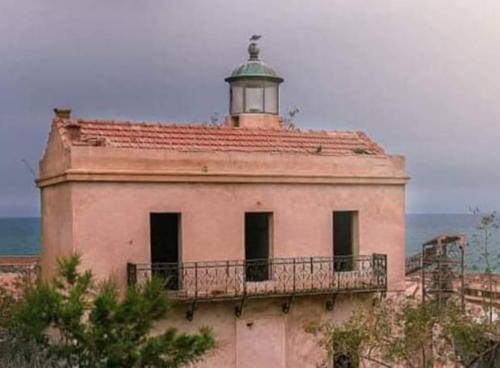
1870. Active; focal plane 81 m (266 ft); two red flashes every 10 s. 15 m (49 ft) square cylindrical masonry tower with lantern and gallery, rising from a 1-story keeper's house. Lighthouse is buff with deep red trim; lantern and gallery black. Aci Kamel's 2022 photo is at right, Aala Ahmed has a 2022 closeup, Brahim Arif has a 2019 photo, Riad Hakiki has a photo, the ONSM page has a view from the sea, and Google has a good satellite view. A 2020 photo shows the lighthouse in need of restoration. Located atop an island about 8 km (5 mi) west of Béni Saf. Accessible only by boat. Site and tower closed. ARLHS ALG-002; Admiralty E6718; NGA 22696.
Îles Habibas
1879. Active; focal plane 112 m (367 ft); white flash every 5 s. 12 m (39 ft) square masonry tower with lantern and gallery, rising from a 1-story keeper's house. Lighthouse painted white, lantern and gallery black. Trabas has Capt. Peter Mosselberger's photo, the Degree Confluence Project has the same photo, and Google has a satellite view. The Captain's photo also shows a stone obelisk that may have served as a daymarker before the lighthouse was built. The Îles Habibas consist of two rocky islands about 11 km (7 mi) northwest of Cap Sigale. Located at the summit of the western island. Accessible only by boat. Site and tower closed. Site manager: Réserve Naturelle Marine des Îles Habibas. ARLHS ALG-001; Admiralty E6714; NGA 22684.

Îles Rachgoun Light, Béni Saf, September 2022
Google Maps photoby Aci Kamel

Oran Province Lighthouses
Oran is a major port and the second largest city in Algeria, with an estimated population of 6 million in the metropolitan area.

Île Plane
Date unknown. Active (?); focal plane 24 m (79 ft); two white flashes every 6 s. 6 m (20 ft) round stone tower with lantern and gallery. 1-story keeper's cottage or utility building. Tower painted with red and black horizontal bands (an internationally recognized "isolated danger" daymark). Trabas has Capt. Peter Mosselberger's distant view and Google has a satellite view. Endangered: The tower appears dilapidated in Mehdi Seddiki's 2022 closeup photo. Note: there is also an Île Plane ("flat island") lighthouse in Tunisia. Located on a small island about 7 km (4.5 mi) due west of Cap Falcon. Accessible only by boat. Site status unknown. Admiralty E6712; NGA 22676.
Cap Falcon
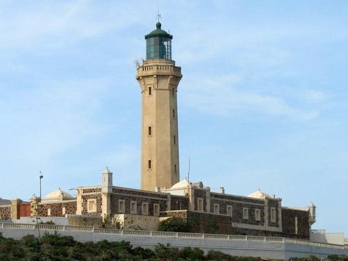
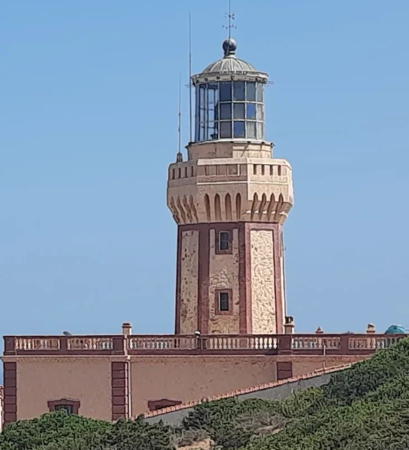
1868. Active; focal plane 104 m (341 ft); four white flashes every 25 s. 27 m (89 ft) octagonal cylindrical stone tower with lantern and gallery, attached to the front of a 1-story stone keeper's house. An ONSM photo is at right, Mohamed Bisker has a 2007 photo, a 2021 photo is available, Trabas has Capt. Peter Mosselberger's distant view, Forand has a historic postcard view, and Google has a good satellite view. The lighthouse marks the western entrance to the Bay of Oran and is the traditional landfall light for Oran. Located on the cape, about 5 km (3 mi) northwest of Aïn el-Türck. Site status unknown. ARLHS ALG-003; Admiralty E6708; NGA 22672.
[Mers el-Kebir]
1868. Destroyed during World War II, this was a 23 m (75 ft) octagonal tower rising from a keeper's house. The lighthouse was not replaced after the war. Alain Michot has posted a prewar photo and a 1963 photo. A 2022 photo shows only the foundations of the light station. Google has a satellite view. The lighthouse was at the eastern end of a historic fortress. Located on a sharp promontory north of Mers-el-Kebir, at the western entrance to the Bay of Oran. ARLHS ALG-025.
 

Cap Falcon Light, Aïn el-Türck
Office National de Signalisation Maritime photo
Oran Jetée du Large (Jetée Fellaoucene) (2)
1905 (station established 1868). Active; focal plane 21 m (69 ft); three white flashes, in a 2+1 pattern, every 15 s. 15 m (49 ft) tripod cast iron tower with lantern, gallery, and watch room. Lighthouse painted white, lantern black. A distant view is available and Google has a satellite view. This lighthouse replaced the enclosed cast iron tower shown in Forand's postcard view; that lighthouse was overthrown by a storm in November 1900. Located at the end of the breakwater mole at Oran. Site status unknown, but there should be good views from the waterfront. ARLHS ALG-039; Admiralty E6678; NGA 22584.
Cap de l'Aiguille
1906. Active; focal plane 62 m (203 ft); two white flashes every 10 s. 10 m (33 ft) round tower with lantern and gallery. Tower painted white, lantern dark green. Aymen Abdelali has a 2020 photo, a 2021 photo is available, and Google has a satellite view. The cape is sharp enough to be called l'Aiguille (The Needle), but there is also a rocky pinnacle just off the cape that has that name. Located on a sharp cape at the eastern entrance to the Bay of Oran, about 30 km (20 mi) northeast of the city. Site status unknown. ARLHS ALG-027; Admiralty E6674; NGA 22580.
Îlot d'Arzew (2)
1848. Active; focal plane 19 m (62 ft); red flash every 5 s. 12 m (39 ft) round tower with lantern and gallery, rising from a 1-story keepers house. Lighthouse painted white, lantern dark green. A 2023 photo is at right, Sofiane Oulahcene' has a 2022 photo, Guyomard and Carceller have a photo, François Canto has a 2009 photo, Maya-Anaïs Yataghène has a 2011 photo, Abdelkader Cherki has a photo, Lightphotos.net has a photo, a 2007 photo is available, Forand has a historic postcard view, and Google has a satellite view. Located on a small island off Cap Arzew, about 2.5 km (1.5 mi) northeast of the port of Arzew. Accessible only by boat, although there are clearly good views from the mainland. Site and tower closed. ARLHS ALG-052; Admiralty E6672; NGA 22540.
Arzew Jetée du Large
Date unknown. Active; focal plane 15 m (49 ft); four white flashes every 6 s. 14 m (46 ft) concrete tower painted white with a black top. No photo available but Google has a satellite view. Located at the end of the main breakwater of Arzew, a mostly industrial port 40 km (25 mi) east of Oran. Site status unknown. Admiralty E6670; NGA 22552.

Îlot d'Arzew Light, Arzew, August 2023
Google Maps photo by EmaD K

Mostaganem Province Lighthouses
Mostaganem is a seaport about 75 km (47 mi) east of Oran. The city has a population of about 250,000.

*
Mostaganem (2)
1859 (station established 1844). Inactive (since 1914?). Approx. 12 m (39 ft) square cylindrical tower with lantern attached to a keeper's house. Mohamed Belmedy has the 2021 photo seen at right, he has another 2021 photo, Lightphotos.net has a closeup photo and Google has a satellite view. This historic lighthouse does not seem to be well known. Located at the north end of the Rue Martin Luther King, overlooking the harbor of Mostaganem. Site open, tower closed. ARLHS ALG-062.
Mostaganem Traversée Sud Ouest
Date unknown. Active; focal plane 13 m (43 ft); green light occulting twice every 6 s. 7 m (23 ft) post centered on a 1-story hexagonal concrete equipment room. Lighthouse unpainted, post painted green. Trabas has Capt. Peter Mosselberger's photo, Lucian Oniscu has a photo, and Google has a satellite view. Located at the end of the west breakwater mole at the entrance to Mostaganem harbor. Site status unknown. Admiralty E6662; NGA 22532.
Mostaganem Môle de la Libération (Jetée du Sud-Ouest) (3)
Date unknown (station established 1903). Active; focal plane 11 m (36 ft); green flash every 4 s. 7 m (23 ft) post centered on a 1-story hexagonal concrete equipment room. Lighthouse unpainted, post painted green. Trabas has Capt. Peter Mosselberger's photo and Google has a satellite view. The original light was a short pylon; Forand has a postcard view of a cast iron tourelle that probably replaced it around 1914. Located at the end of the quay opposite the Jetée Nord Spur Light. Site status unknown. ARLHS ALG-059; Admiralty E6664; NGA 22528.

Mostaganem Light, Mostaganem, July 2021
Google Maps photo by Mohamed Belmedy
Mostaganem Jetée Nord Spur (3)
Date unknown (station established 1899). Active; focal plane 11 m (36 ft); red light occulting twice every 6 s. 7 m (23 ft) post centered on a 1-story hexagonal concrete equipment room. Lighthouse unpainted, post painted red. Trabas has Capt. Peter Mosselberger's photo and Google has a satellite view. The original light was a short pylon; a cast iron tourelle replaced it around 1914. Huelse has a historic postcard view showing this tourelle on the left and the Jetée du Sud-Ouest light at the extreme right. Located on a short spur of the breakwater mole marking the entrance to the inner harbor of Mostaganem. Site status unknown; the light must be easy to see from the waterfront. ARLHS ALG-058; Admiralty E6661; NGA 22536.
Mostaganem Jetée Nord (2)
Date unknown (station established 1902). Active; focal plane 17 m (56 ft); four flashes every 15 s, white or red depending on direction. 10 m (33 ft) round cylindrical concrete tower with lantern and gallery. Upper half of the lighthouse painted red, lower half white. Trabas has Capt. Peter Mosselberger's photo, Lucian Oniscu has a photo, a distant view is available, and Google has a satellite view. The modern light replaced a cast iron tourelle. Forand has a postcard view that shows all three of the cast iron lights, this one being at the far left. Located on the end of the breakwater mole at Mostaganem. Site status unknown; the light must be easy to see from the waterfront. ARLHS ALG-041; Admiralty E6660; NGA 22524.
* Cap Ivi (Cap Ouillis)
1898. Active; focal plane 118 m (387 ft); white flash every 5 s. 18 m (59 ft) octagonal stucco-clad masonry tower with lantern and castellated gallery, rising from a 2-story keeper's house. The lighthouse is painted white; formerly it was painted yellow with brown trim. A 2022 photo is at right, a 2008 closeup photo and a 2010 view are available, and Google has a satellite view. Located on a headland about 25 km (15 mi) northeast of Mostaganem, directly on the N11 coastal highway. Site open, tower closed. . ARLHS ALG-013; Admiralty E6658; NGA 22520.

Cap Ivi Light, Mostaganem, September 2022
Instagram photo by my_discovery_dz

Chlef Province (Ténès Area) Lighthouses
Ténès is an ancient seaport founded by Phoenician sailors some 2800 years ago. Located about 200 km (125 mi) west of Algiers, the town has a population of about 35,000.

Pointe Columbi (El Marsa, Nadji)
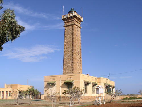
Date unknown. Active; focal plane 60 m (197 ft); three white flashes every 15 s. 29 m (95 ft) square cylindrical stone tower with lantern and gallery attached to a 1-story keeper's house. An ONSM photo is at right, Mesrine Merie has a photo, Mosta Motard has a closeup, Wikimedia has a photo, a 2021 photo is available, and Google has a good satellite view. Located on a headland about 5 km (3 mi) northeast of El Marsa. Site status unknown. ARLHS ALG-042; Admiralty E6656; NGA 22512.
Ténès Jetée Ouest
Date unknown. Active; focal plane 10 m (33 ft); green light occulting twice every 6 s. 7 m (23 ft) stone post mounted on a 1-story stone base. The lighthouse is unpainted. Fayssal Babouri has a very distant view and Google has a satellite view. Located at the end of the west breakwater at Ténès. Site status unknown. ARLHS ALG-067; Admiralty E6650; NGA 22496.
Ténès Jetée Est
Date unknown. Active; focal plane 10 m (33 ft); red light occulting twice every 6 s. 8 m (26 ft) stone post mounted on a 1-story stone base. The lighthouse is unpainted. Fayssal Babouri has a very distant view and Google has a satellite view. Located at the end of the east breakwater at Ténès. Site status unknown. ARLHS ALG-066; Admiralty E6651; NGA 22492.
* Cap Ténès
1865. Active; focal plane 89 m (292 ft); two white flashes every 10 s. 31 m (102 ft) square cylindrical stone tower with lantern and gallery rising from the front of a 2-story stone keeper's house. Lighthouse painted white, lantern dark green. Mohamed Benzira's 2023 photo is at right, a 2008 photo is available, Lightphotos.net has Kamel Lebtahi's photo and a view by Ghalem Arsalan, Forand has a historic postcard view, and Google has a good satellite view. Located on a headland about 8 km (5 mi) northeast of Ténès. Site open, tower closed. . ARLHS ALG-018; Admiralty E6646; NGA 22488.
* Beni Haoua Secondary Jetty
Date unknown. Active; focal plane about 16 m (52 ft); white light, pattern unknown. Approx. 12 m (39 ft) round cylindrical white concrete tower. Fahed Chater has a photo, Abdelsamie Toubal has a distant view and Google has an indistinct satellite view. Located on the inner (west) breakwater at Beni Haoua, a small port in eastern Chlef Province. Site open, tower closed. Admiralty E6645.2.
* Beni Haoua Main Jetty
Date unknown. Active; focal plane about 16 m (52 ft); red light, pattern unknown. Approx. 10 m (33 ft) round cylindrical white concrete tower. Fahed Chater has a photo, Abdelsamie Toubal has a distant view and Google has an indistinct satellite view. Located on the main (east) breakwater at Beni Haoua. Site open, tower closed. Admiralty E6645.3.

Tipaza Province Lighthouses
Îlot Tokikt (Tokih Indich) (2)
2021. Active; focal plane 12 m (39 ft); two white flashes every 6 s. 8 m (26 ft) round tower painted with black and red horizontal bands. A 2021 photo is available and Google has a satellite view. This light replaced a square white concrete tower; Haouchine Hamza has a 2020 photo showing that lighthouse was demoloshed. Located on an isolated rocky reef about 5 km (3 mi) northeast of Larhat. Accessible only by boat. Site status unknown. Admiralty E6644; NGA 22486.
Cherchell (Fort Joinville)
1855. Active; focal plane 37 m (121 ft); three white flashes, in a 2+1 pattern, every 15 s. 26 m (85 ft) round stone tower with lantern and gallery. Long unpainted, the lighthouse has been painted white in recent years; lantern painted black. A. Nasser Hakem's 2020 photo appears at the top of the page, Amine Lido has a 2021 photo, Wikimedia has several photos, a panoramic view is available, Habib Kaki also has a wide view, and Google has a satellite view. Cherchell is a small port about 90 km (55 mi) west of Algiers. It has an illustrious history dating back to an Egyptian settlement dating to about 1500 BC; in Roman times it was known as Caesarea and served as the capital of the Roman kingdom of Mauretania. The lighthouse is inside the walls of Fort Joinville, built by the French on an island sheltering the harbor. The island is connected to land by a breakwater. Site status unknown. ARLHS ALG-019; Admiralty E6636; NGA 22468.


Pointe Columbi Light, Ténès
Office National de Signalisation Maritime photo


Cap Ténès Light, Ténès, August 2023
Google Maps photo by Mohamed Benzira

Grand Hammam (Hamman)
Date unknown. Active; focal plane 13 m (43 ft); quick-flashing white light. 12 m (39 ft) solid white concrete pillar. The light is atop an old acetylene cylinder at the peak of the tower. Mohand Mouhou has a photo and Google has a satellite view. Located on a rocky reef just outside Cherchell harbor. Accessible only by boat. Site status unknown. Admiralty E6637; NGA 22484.
* Ra's el Kalia (Tipaza)
1869. Active; focal plane 32 m (105 ft); white light occulting once every 4 s. 11 m (36 ft) square cylindrical masonry tower with lantern and gallery, attached to a 1-story keeper's house. Lighthouse painted white, lantern dark green. A photo is at right, Trabas also has a photo, Guyomard and Carcellet have a distant view by Alexandre Faulx-Briole, Forand has a historic postcard view, and Google has a satellite view. This lighthouse is in a restricted area and no closeup photos have been found. Located at the tip of a peninsula about 2 km (1.2 mi) northeast of Tipasa. Site and tower closed. ARLHS ALG-053; Admiralty E6630; NGA 22444.
* Tipaza Pierhead (New Mole)
Date unknown. Active; focal plane 8 m (26 ft); green flash every 2.5 s. 6 m (20 ft) hexagonal white concrete tower with a green band on the gallery. A 2019 photo is available, Omar Hamdi has a photo showing all three Tipaza lighthouses, and Google has a satellite view. Located on the inner breakwater of Tipaza harbor. Site open, tower closed. Admiralty E6630.6.
* Tipaza Jetée Est
Date unknown. Active; focal plane 11 m (33 ft); continuous red light. 10 m (33 ft) hexagonal white concrete tower with a red band on the gallery. A 2020 closeup photo is available, Habib Kaki has a closeup photo, Omar Hamdi has a photo showing all three Tipaza lighthouses, Blida Ziane has a street view, and Google has a satellite view. Located on the outer breakwater of Tipaza harbor. Site open, tower closed. Admiralty E6630.5.

Tipaza Light, Tipaza, February 2016
Google Maps photo by R Hotel

Information available on lost lighthouses:

Notable faux lighthouses:

Adjoining pages: East: Central Algeria | West: Northeastern Morocco

Return to the Lighthouse Directory index | Ratings key

Posted August 8, 2005. Checked and revised June 9, 2024. Lighthouses: 34. Site copyright 2024 Russ Rowlett and the University of North Carolina at Chapel Hill.