Lighthouses of Northern Tunisia

Smallest of the North African nations, the Republic of Tunisia was a province of the Ottoman Empire until it was occupied by French troops in 1881 and declared a French protectorate. In World War II Allied forces converged on Tunisia from east and west and used it as the springboard for the invasions of Sicily and southern Italy. The country resumed its independence in 1956.

Northern Tunisia faces north on the western basin of the Mediterranean while the rest of the country faces east on the eastern basin. Cape Bon (Ra's at-Taib), east of the capital city of Tunis, is where the coast makes a right angle turn from one basin to the other.

Tunisia is divided into 24 governates (wilayat, sing. wilayah). This page describes the lighthouses of the northern governates, from the Algerian border through the Cape Bon Peninsula.

Arabic is the official language of Tunisia and nearly all residents speak a variety of Arabic called Tounsi. French is widely used in government and media and more than half of the population also speaks French. The Arabic word for a lighthouse is mnarh or manara (منارة). Ra's is a cape, jaza'ir or jazirat is an island, shi'b is a reef, shira' is a bay, and marfa is a harbor. In French phare is the word for a lighthouse, île is an island, cap is a cape, pointe is a promontory or point of land, roche is a rock, récife is a reef, baie is a bay, estuaire is an estuary or inlet, détroit is a strait, rivière is a river, and havre is a harbor.

Most of Tunisia's lighthouses were built by the French within the first 20 years of their colonial government. Today the lighthouses are maintained by Tunisian Lighthouse Services, an agency of the Tunisian Navy. It appears that most of them are maintained by resident civilian keepers with the original French lenses still in place.

ARLHS numbers are from the ARLHS World List of Lights. Admiralty numbers are from volume E of the Admiralty List of Lights & Fog Signals. U.S. NGA List numbers are from Publication 113.

General Sources
La signalisation maritime en Tunisie (1881-1920)
Article (in French) by Jean-Christophe Fichou on the development of Tunisian lighthouses. The article appeared in December 2010 in the Revue des mondes musulmans et de la Méditerranée.
Phares d'Afrique
Photos posted by Alain Guyomard and Robert Carceller as part of their Phares du Monde web site.
Online List of Lights - Tunisia
Photos by various photographers posted by Alexander Trabas.
World of Lighthouses - Tunisia
Photos available from Lightphotos.net.
Leuchttürme in Tunesien
Photos posted by Bernd Claußen.
Lighthouses in Tunisia
Photos by various photographers available from Wikimedia.
Afrikanische Leuchttürme auf historischen Postkarten
Historic postcard images posted by Klaus Huelse.
GPSNauticalCharts
Navigational chart information for Tunisia.
Navionics Charts
Navigational chart for Tunisia.

Ra's Enghela Light
Ra's Enghela Light, Bizerte, 2009
photo copyright Bekir Dildar; used by permission

Jendouba Governate (Tabarka Area) Lighthouses
Tabarka is small seaport in the northwest corner of Tunisia, near the Algerian border.

* Tabarka (Jazirat Tabargah) (2)
1906 (station established 1891). Active; focal plane 72 m (236 ft); white flash every 2.5 s. Approx. 14 m (46 ft) tower with lantern and gallery, rising from a 1-story keeper's house. Tower painted white, lantern and gallery black. A photo is at right, Wikimedia also has a closeup of the lantern, Trabas has a distant view, Gianfranco Conte has a 2018 sunset photo, Jordan Sudermann has a 2004 photo, Tahir Diaa has a view from the harbor, and Google has a satellite view. The lighthouse is built on top of a 16th century fort built by Genoa. Located at the highest point of a former island (now joined to the mainland) that protects the harbor of Tabarka, near the northwestern corner of Tunisia. Tours of the fort are available. Site open, tower closed. . ARLHS TUN-017; Admiralty E6460; NGA 22148.
Tabarka Fishing Harbor North Mole
Date unknown. Active; focal plane 10 m (33 ft); green flash every 4 s. 8 m (26 ft) round cylindrical stone tower, painted green. A 2023 closeup photo is available, Trabas has a photo, and Google has a satellite view. Located at the end of the north mole of the fishing harbor, just east of the Genoese fortress. Site status unknown. Admiralty E6462; NGA 22152.
Tabarka Fishing Harbor East Mole Elbow
Date unknown. Active; focal plane 10 m (33 ft); red flash every 5 s. 8 m (26 ft) square (?) stone tower, painted red. Trabas has a distant view and Google has a satellite view. Located at a bend of the east mole of the fishing harbor, just east of the Genoese fortress. Site status unknown. Admiralty E6462.4; NGA 22156.
Tabarka Light
Tabarka Light and Fort de Tabarka, Tabarka, December 2014
Wikimedia Creative Commons photo by Citizen59

Bizerte (Banzart) Governate Lighthouses
Bizerte is a historic city of about 150,000 residents. Founded by the Phoeniceans about 1100 BCE, it was called Hippo in Roman times. A short canal connects the sea to a large lake that forms the inner harbor. Because the city was an important French naval base, France kept control of the city after Tunisia became independent in 1956. The French finally withdrew in 1963 as a result of pressure from the United Nations.
Galiton de l'Ouest
1920. Active; focal plane 168 m (551 ft); four white flashes every 20 s; a continuous red light is shown over a narrow sector to the west southwest. 14 m (46 ft) square cylindrical tower with lantern and gallery rising from a 2-story keeper's house. Light tower and lantern painted black; keeper's house is gray with white trim. Lightphotos.net has a photo, Wikimedia has Issam Barhoumi's distant photo (a portion is seen at right), Trabas has a distant view by Capt. Peter Mosselberger, and Google has a satellite view. The Galite Islands are small, precipitous islands located about 30 km (19 mi) northwest of Cap Serrat. The lighthouse is perched on the highest point of an island at the west end of the group. Its construction was delayed repeatedly by high costs and engineering difficulties. Accessible only by boat. Site and tower closed. ARLHS TUN-016; Admiralty E6464; NGA 22144.
Sidi Mechrig (Mechreg) Outer
Date unknown. Active; focal plane 10 m (33 ft); green flash every 4 s. 5 m (16 ft) round strongly conical stone tower painted green. Leith Abidi has a 2019 photo showing both Sidi Mechrig lights (this one on the left) and Google has an indistinct satellite view. Located on the south side of the entrance to the small port of Sidi Michreg, about 16 km (10 mi) southwest of Cap Serrat. Site status unknown. Admiralty E6459.1; NGA 22139.
Sidi Mechrig (Mechreg) West Jetty
Date unknown. Active; focal plane 10 m (33 ft); red flash every 5 s. 5 m (16 ft) round strongly conical unpainted stone tower. Leith Abidi has a 2019 photo showing both Sidi Mechrig lights (this one on the right), Hiba Zouaghi has a 2020 photo, and Google has an indistinct satellite view. Located on a jetty on the north side of the entrance to the small port of Sidi Michreg, about 16 km (10 mi) southwest of Cap Serrat. Site status unknown. Admiralty E6459; NGA 22138.
Cap Serrat
1890. Active; focal plane 199 m (653 ft); two white flashes every 10 s; red flashes are shown in a sector close to shore to the southwest. 13 m (43 ft) square cylindrical tower with lantern and gallery, rising from a 1-story keeper's house. Lighthouse painted black with a broad white horizontal band under the gallery. The coastal management agency has a photo of the station, a view from the sea is available, Wikimedia has a very distant view, and Google has a satellite view. Located atop a steep bluff about halfway between Bizerte and Tabarka. Site status unknown (the lighthouse is in a remote area). ARLHS TUN-015; Admiralty E6458; NGA 22136.

Galiton de l'Ouest Light, Îles de la Galite, October 2015
Wikimedia Creative Commons photo by Issam Barhoumi
Ra's Enghela (Cap Angela)
1890. Active; focal plane 38 m (125 ft); white flash every 2.5 s; red flashes are shown in a sector close to shore to the southwest. 15 m (49 ft) square cylindrical tower with lantern and gallery, rising from a 1-story keeper's house. Lighthouse painted black with a broad white horizontal band under the gallery. An 8 m (26 ft) square white tower carries a red panel that creates the red sector of the light. Bekir Dildar contributed the photo at the top of this page (note the secondary tower with the red panel), Jacem Guezguez has a 2023 photo, Aymen Akkari has a view from a nearby beach, another view is available, and Google has a satellite view of the station. This is the northernmost lighthouse of the African continent, standing in latitude 37° 20.7' N. Construction began in 1888. Located on a headland about 12 km (7.5 mi) northwest of Bizerte. Site status unknown. ARLHS TUN-026; Admiralty E6456; NGA 22132.
Bizerte Outer Breakwater North End
Date unknown. Active; focal plane 10 m (33 ft); two red flashes every 10 s. 8 m (26 ft) round concrete tower, painted red. Nizar Grindi has a closeup street view and Google has a satellite view. Located at the northwest end of the detached outer breakwater of Bizerte. Accessible only by boat. Site and tower closed. Admiralty E6422; NGA 22076.
Bizerte Outer Breakwater South End
Date unknown. Active; focal plane 15 m (49 ft); green light, 2 s on, 2 s off. 8 m (26 ft) round concrete tower, painted green (NGA says white with a black top, but this is an error). Dominique Touel has a photo of a dolphin passing the lighthouse, Nizar Grindi has a distant street view, and Google has a satellite view. Located at the southwest end of the detached outer breakwater of Bizerte. Accessible only by boat. Site and tower closed. Admiralty E6420; NGA 22068.
* Bizerte Jetée Nord
Date unknown. Active; focal plane 15 m (49 ft); continuous green light. 8 m (26 ft) round concrete tower, painted green. Wikimedia has a photo, Harzi Zied has a 2020 photo, Youssef Trabelsi has a closeup street view, and Google has a satellite view. Located at the end of the north breakwater of Bizerte; accessible by walking the pier. Site open, tower closed. ARLHS TUN-014; Admiralty E6426; NGA 22080.
Bizerte Jetée Est (2)
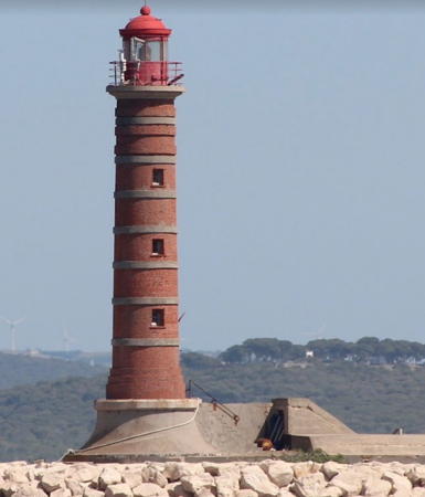
1914 (station established 1895). Active; focal plane 24 m (79 ft); red light, 2 s on, 2 s off. 17 m (56 ft) tower with lantern. The lighthouse appears to be unpainted red stone; lantern painted red. Frank Zhang's 2023 photo is at right, Hamza Hnini has a 2016 closeup photo, a distant view is available, Nizar Grindi has a distant street view, and Google has a satellite view. The height listed, 17 m, seems too low for the focal plane. Located at the end of the east inner jetty of Bizerte harbor. Site status unknown. Admiralty E6428; NGA 22084.
* Pointe de Sebra
1895. Active; focal plane 16 m (52 ft); isophase white light, period not listed. 15 m (49 ft) square cylindrical skeletal tower with enclosed upper portion. Lantern removed. The enclosed portion is painted with black and white vertical stripes; the rest of the tower is painted white. No current photo available but Google has a satellite view. This light helps guide ships through the Goulet, the short canal connecting the Bizerte harbor to Lake Bizerte. Located on a point of land on the north shore of Lake Bizerte that is aligned with the channel of the canal. Site and tower closed. ARLHS TUN-025; Admiralty E6440; NGA 22104.

Jetée Est (East Jetty) Light, Bizerte, April 2023
Google Maps photo by Frank Zhang
* Menzel Bourguiba
Date unknown. Inactive since 2011. 20 m (66 ft) round tower, rising from the port captain's office. Lighthouse painted white. No photo available but Google has a satellite view. Menzel Bourguiba (named for Tunisia's longtime president Habib Bourguiba) is the former Ferryville (named for Jules Ferry, the French prime minister who sent troops to occupy Tunisia in 1881). Located on the southwestern shore of Lake Bizerte. Site open, tower closed. ARLHS TUN-030; ex-Admiralty E6444; ex-NGA 22108.
Bizerte Port de Pêche (Menzel-Abderrahman)
Date unknown. Active; focal plane 9 m (30 ft); red flash every 5 s. 8 m (26 ft) round concrete tower painted red. Ghorbel Rached has a 2020 photo, Frédéric Bastiani has a very distant view and Google has a satellite view. Located on the main breakwater of a small boat harbor on the north shore of Lake Bizerte. Accessible by walking the pier. Site open, tower closed. Admiralty E6454; NGA 22106.
Cap Zebib (Ras as Zabib) East Jetty
Date unknown. Active; focal plane 10 m (33 ft); green flash every 4 s. 5 m (16 ft) round green concrete tower. Jihed Dghaies has a distant view, Zine Kou has a view of both jetty lights, and Google has a satellite view. Located on the outer breakwater of a fishing harbor on a cape about 16 km (10 mi) east of Bizerte. Site status unknown. Admiralty E6418; NGA 22065.
Cap Zebib (Ras as Zabib) West Jetty
Date unknown. Active; focal plane 10 m (33 ft); red flash every 5 s. 7 m (23 ft) round red concrete tower. Zine Kou has a view of both jetty lights and Google has a satellite view. Located on the inner breakwater of the harbor of Cap Zebib. Site status unknown. Admiralty E6418.1; NGA 22066.
Îles Cani (Dog Rocks)
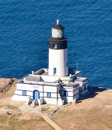
1860. Active; focal plane 39 m (128 ft); two flashes every 10 s, white or red depending on direction. 21 m (69 ft) round stone tower with lantern and gallery rising from 1-story keeper's house complex. Lighthouse painted with black and white horizontal bands; lantern is black. Dilou Anis has a photo (also seen at right), Bessrour Ridha has a 2020 view from the sea, Wikimedia has a historic postcard view, and Google has a fine satellite view. This is Tunisia's second oldest lighthouse; it was built by the British, with the permission of the Bey of Tunis, after the 1856 wreck of HMS Spartan stranded British soldiers on the island. The Îles Cani are two small islands about 12 km (7.5 mi) off Ra's Zebib, on the approaches to Bizerte. Located on Grand Île Cani. Accessible only by boat. Site and tower closed. ARLHS TUN-004; Admiralty E6416; NGA 22064.

Îles Cani Light, Bizerte, August 2017
Google Maps photo by Dilou Anis
Île Plane (Jazirat al Mussattahah)
1888. Active; focal plane 20 m (66 ft); two white flashes every 10 s; red flashes are shown over a sector to the west. 12 m (39 ft) square stone tower with lantern and gallery, attached to a 1-story stone keeper's house. Lighthouse painted with red and white horizontal bands. Wikimedia has Ahmed Abdelmoumen's photo, Samir Abdallah has a distant view, and Google has a satellite view. Note: there is also an Île Plane lighthouse near Oran in Western Algeria. Located on Île Plane, a remarkably flat-topped island about 2 km (1.2 mi) off Cape Farina (Ra's Sidi Ali el-Mekki) near Ghar el-Mehl at the northwestern entrance to the Gulf of Tunis. Accessible only by boat. Site and tower closed. ARLHS TUN-024; Admiralty E6414; NGA 22056.

Tunis Governate Lighthouses
The national capital of Tunis has a metropolitan population of about 2.7 million. As at Bizerte a short canal leads to an interior lake, but Lake Tunis is much smaller than Lake Bizerte.
* Ra's Qatarjamah (Sidi Bou Saïd, Cape Carthage)
1840. Active; focal plane 146 m (479 ft); white flash every 4 s. 12 m (39 ft) round cylindrical tower with lantern and gallery. Tower painted white with a black band at the top; lantern and gallery painted black. A photo is at right, Lightphotos.net has a 2013 closeup photo, Brent Scheneman has a photo, Trabas has a photo by Rainer Arndt, Huelse has a historic postcard view, Fares Bouhlila has a street view, and Google has a satellite view. This lighthouse, Tunisia's oldest, stands atop a high hill at the northern entrance to the Bay of Carthage (now the Bay of Tunis). The hill is called Jebel el-Manar, "Fire Mountain," because fires were built here as long ago as Phoenician times to guide sailors into the bay. The Moslem saint Abu Said Ibn Khalef Ibn Yahia el-Beji, who was called Bou Saïd, was buried here in 1231, making this a famous place of pilgrimage. Located near La Marsa, about 20 km (13 mi) northeast of Tunis. Site open, tower closed. ARLHS TUN-012; Admiralty E6412; NGA 22040.
Tunis Dique Nord (North Breakwater)
Date unknown. Active; focal plane 9 m (30 ft); green flash every 4 s. 7 m (23 ft) round concrete tower with four ribs. Entire lighthouse is green. Gert Löffler has a photo, Trabas has Rainer Arndt's photo (light in the foreground) and a distant view from an arriving ship, and Google has a satellite view. Located on the long, curved north breakwater at the entrance to Tunis. Site and tower closed (the breakwater is not walkable). Admiralty E6397; NGA 22002.
Tunis Jetée Nord (North Jetty)
Date unknown. Active; focal plane 13 m (43 ft); red flash every 5 s. 11 m (36 ft) red concrete tower. Trabas has Rainer Arndt's photo (light in the background), Loic le Brusq has a photo, Trabas has Rainer Arndt's photo (light in the center), and Google has a satellite view. Located on a short jetty off the end of the main pier. Site status unknown. Admiralty E6397.5; NGA 22000.
* La Goulette (Tunis Jetée Nord)
Date unknown (station established 1850). Active; focal plane 13 m (43 ft); three white flashes every 12 s. 10 m (33 ft) lantern, gallery, and watch room mounted on four concrete legs. The legs are unpainted; lantern, gallery and watch room painted green. Hassène Alaya has a view from the harbor, Joerg Poelmeyer has a similar view, and Google has a satellite view. La Goulette is the commercial port of Tunis. The light is located at the end of the main pier, so there should be a good view from arriving cruise ships and trans-Mediterranean ferries. Site open, tower closed. Admiralty E6396; NGA 21996.
Tunis Canal No. 21
Date unknown. Active; focal plane about 7 m (23 ft); green light, pattern unknown. Approx. 7 m (23 ft) round green metal tower atop a round stone tower. Google has a street view and a satellite view. The Tunis Canal is a dredged channel leading to an inner harbor basin. Located on the north side of the canal near its beginning. Easy to see from shore. Site open, tower closed. Admiralty E6409.21.
Sidi Bou Said Light
Sidi Bou Saïd Light, Tunis, October 2006
Wikimedia Creative Commons photo by Kassus
Tunis Dique Sud (South Breakwater) (2?)
Date unknown. Active; focal plane 9 m (30 ft); red flash every 5 s. 7 m (23 ft) round concrete tower with four ribs. Entire lighthouse is red. Marcus Weiß has a photo, Julia Roth also has a photo, and Google has a satellite view. NGA describes a conical tower. Located on the long, curved south breakwater at the entrance to Tunis. Site and tower closed (the breakwater is not walkable). Admiralty E6399; NGA 22004.

Nabeul Governate (Cape Bon Peninsula) Lighthouses
Cape Bon (Ra's at-Taib) is the tip of a mountainous peninsula enclosing the east side of the Gulf of Tunis. The cape is at the narrowest point of the Mediterranean Sea; from here it is only 145 km (90 mi) northeast to Sicily.

* Sidi Daoud Jetée Sud (South Jetty) (2)
Date unknown. Active; focal lane about 10 m (33 ft); two green flashes evry 10 s. Approx. 8 m (26 ft) round green concrete tower. Odai Marisi has a photo and Google has a satellite view. NGA lists a light with a focal plane of only 3 m (10 ft). Located on the south jetty at Sidi Daoud, a fishing port about 30 km (19 mi) southwest of Cap Bon. Probably accessible by walking the pier. Site open, tower closed. Admiralty E6394.61; NGA 21991.
* Sidi Daoud Jetée Nord (North Jetty) (2)
Date unknown. Active; focal lane about 10 m (33 ft); two red flashes evry 10 s. Approx. 8 m (26 ft) round red concrete tower. Trabas has a photo, Odai Marisi has a photo, and Google has a satellite view. NGA lists a light with a focal plane of only 3 m (10 ft). Located on the north jetty at Sidi Daoud. Probably accessible by walking the pier. Site open, tower closed. Admiralty E6394.5; NGA 21990.
Île Zembretta (1)
Date unknown. Inactive. 8 m (26 ft) square cylindrical tower with gallery attached to a keeper's house. Originally the lantern and top of tower were painted black, the rest of the tower white. Seif Eddine Khedhri's 2017 view from the sea shows that the lantern has been removed and the light has been moved to a skeletal mast (focal plane 59 m (194 ft); white flash every 4 s). Ayoub Cherif has a distant view and Google has a satellite view. The islands of Zembra and Zembretta lie off the northwest side of the Cap Bon peninsula; they were declared an international biosphere reserve in 1977. Located about 12 km (7.5 mi) west of Cap Bon. Accessible only by boat. Site and tower closed. ARLHS TUN-028. Active light: Admiralty E6394; NGA 21988.
Ra's al Ahmar
Date unknown. Active; focal plane about 12 m (39 ft); red flash every 5 s. Approx. 7 m (23 ft) red tower. No photo available but Google has a satellite view. Located on a rocky point about 16 km (10 mi) west of Cap Bon. Site status unknown. Admiralty E6393.
Cap Bon (Ra's at-Taib)
1875. Active; focal plane 126 m (413 ft); three white flashes every 20 s. 20 m (66 ft) tower with lantern and gallery, attached to the seaward side of a keeper's house. Lantern and top of tower painted black, rest of tower white. Jihed Hameda has the 2019 drone view at right, Jacques Morin has a 2017 photo and closeup, Claußen has a distant view, and Google has a satellite view. Located atop a steep bluff at the extreme northeastern corner of Tunisia. Site status unknown. . ARLHS TUN-006; Admiralty E6392; NGA 21984.
 

Cap Bon Light, Haouaria, March 2019
Google Maps drone view by Jihed Hameda
 
El Haouaria East Breakwater
Date unknown. Active; focal plane about 12 m (39 ft); green flash every 4 s. Approx. 6 m (20 ft) round green concrete tower. Medbechir Romdhan has a closeup photo, Anis Tounsi has a view across the harbor, another view shows this light just left of center, and Google has a satellite view. Located on the east (outer) breakwater of El Haouaria, a small port sheltered by the headland of Cap Bon. Site status unknown. Admiralty E6392.6.
El Haouaria West Inner Breakwater
Date unknown. Active; focal plane about 12 m (39 ft); white flash every 5 s. Approx. 6 m (20 ft) round red concrete tower. A view of the harbor shows this light on the right and Google has a satellite view. Located on what was probably the original west breakwater, now an inner breakwater of El Haouaria. Site status unknown. Admiralty E6392.64.
* Qulaybiyah (Kélibia, Ra's Mostefa)
1888. Active; focal plane 82 m (269 ft); four white flashes every 20 s. 18 m (59 ft): square tower with lantern mounted on the east bastion of the Kélibia fortress. Tower painted white, lantern black. Youssef ben Saad's photo is at right, a similar 2008 photo is available, Wikimedia also has Wael Ghabara's photo, Frank Trieu has a street view from the other end of the fort, and Google has an indistinct satellite view. Built in the late 6th century, the great fortress of Kélibia crowns a hill near the northeasternmost point of Tunisia with a spectacular view of the central Mediterranean. Located at Qulaybiyah near the eastern point of the Cap Bon peninsula. Site and fortress open, tower closed. ARLHS TUN-001; Admiralty E6390; NGA 21980.
Qulaybiyah (Kélibia) South Breakwater (2)
Date unknown. Active; focal plane about 14 m (46 ft); two white flashes every 8 s. Approx. 11 m (36 ft) round white concrete tower. Jihed Hameda has a distant view and Google has a satellite view. NGA lists a 5 m (16 ft) pylon. Located on the south (main) breakwater of the Kélibia fishing port, in the shadow of the fortress. Site status unknown. Admiralty E6390.4; NGA 21977.
* Beni Khiar (Nabeul)
Date unknown. Active; focal plane 6 m (20 ft); red flash every 5 s. Approx. 7 m (23 ft) round concrete tower with gallery, painted red. Bogdan Augustyn has a photo, another photo is available, and Google has a satellite view. We need information on the history of this lighthouse. Located at the end of the old south jetty, now within the protected harbor of Beni Khiar, about 15 km (9 mi) northeast of Hammamet. Probably accessible by walking the jetty, but if not the lighthouse can be seen from nearby. Site open, tower closed. Admiralty E6389.8.

Qulaybiyah (Kélibia) Light, Qulaybiyah, August 2016
Wikimedia Creative Commons photo by Youssef ben Saad
* Hammamet
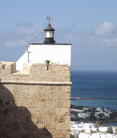
1912. Active; focal plane 17 m (56 ft); two white flashes every 6 s. 14 m (46 ft): white cylindrical lantern atop the wall of the Kasbah (citadel). Trabas has a closeup, Wikimedia has a photo, Lightphotos.net has a photo, Claußen also has a photo, Mohamed Ghomrasni has a street view, and Google has a satellite view. Located in Hammamet, a resort town at the base of the Cap Bon peninsula about 100 km (60 mi) southeast of Tunis. Site open, tower closed. ARLHS TUN-029; Admiralty E6386; NGA 21976.5.
* Port Yasmine
2009(?). Active; focal plane 17 m (56 ft); two long (2.5 s) white flashes every 15 s. Lantern mounted atop a 3-story harbormaster's office building. Bernard Ancel has a closeup photo of the building, a view from the harbor is available, and Google has a satellite view. Port Yasmine is a recently-developed yacht harbor about 13 km (8 mi) southwest of Hammamet. Located on the east side of the harbor entrance. Site and building open. Site manager: Port Yasmine. Admiralty E6386.1; NGA 21976.51.

Information available on lost lighthouses:

Notable faux lighthouses:

Adjoining pages: South: Southern Tunisia | West: Eastern Algeria

Return to the Lighthouse Directory index | Ratings key

Posted July 21, 2005. Checked and revised May 15, 2023. Lighthouses: 37. Site copyright 2023 Russ Rowlett and the University of North Carolina at Chapel Hill.