Lighthouses of Eastern Estonia

The Republic of Estonia (Eesti in Estonian) is a small country with a surprisingly long coastline. Surrounded on 2-1/2 sides by water, it faces the Gulf of Riga (Liivi Laht) on the southwest, the Baltic Sea (Läänemere) on the west, and the Gulf of Finland (Soome Lahe) on the north. The country includes two large islands in the Baltic, Saaremaa and Hiiumaa, and countless small islands. To guard these coasts, Estonia has more than 100 lighthouses and a well-developed lighthouse administration.

Estonia's independence is recent. The country was part of the Swedish Empire from 1625 to 1710 and then part of the Russian Empire from 1710 until the end of World War I in 1918. After two decades of independence it was incorporated into the Soviet Union from 1940 to 1990. Thus the older lighthouses are from the Russian Imperial period and some of the newer ones are of Soviet construction.

Estonia is divided into 15 counties (maakonnad) and the counties are subdivided into towns (linnad) and rural parishes (vallad). This page includes the lighthouses of eastern Estonia, including the counties of West and East Viru and the shores of Lake Peipsi. Viru, or Virumaa, is the region known historically as Vironia.

In Estonian a lighthouse is a tuletorn (fire tower), a tulepaak (fire beacon), or a majakas (borrowed from the Finnish word majaka for a lighthouse). A daybeacon is called a päevamärk, saar is an island, poolsaar is a peninsula, madal or parv is shoal, kari is a reef, neem is a cape or headland, väin is a strait, jõgi is a river, and sadam is a port or harbor.

Names in curly brackets {} are non-Estonian former names (Swedish or German).

Lighthouses in Estonia were operated previously by the Estonian Maritime Administration (Veeteede Amet, or VTA). In 2021 the functions of VTA were folded into the Estonian Transport Administration (Transpordiamet).

ARLHS numbers are from the ARLHS World List of Lights. VTA numbers are from the web site of the Estonian Maritime Administration. Admiralty numbers are from volume C of the Admiralty List of Lights & Fog Signals. U.S. NGA List numbers are from Publication 116.

General Sources
Navigatsioonimärkide andmekogu (Database of navigation signs)
Copied from the former VTA web site, photos and data for all the VTA beacons.
Eesti Tuletorni Selts
Web site of the Estonian Lighthouse Society (in Estonian).
Online List of Lights - Estonia
Photos by various photographers posted by Alexander Trabas.
Leuchttürme in Estland
Photos by Andreas Köhler taken in the summer of 2016.
Lighthouses in Estonia
Photos by various photographers available from Wikimedia.
World of Lighthouses - Estonia
Photos by various photographers available from Lightphotos.net.
Leuchttürme an der estländischen Ostseeküste
Photos of 8 Estonian lighthouses posted by Bernd Claußen.
Lighthouses Estonia
Photos by Joke Reijnen.
Six Remarkable Estonian Lighthouses
Information posted by Cybernetica AS, an Estonian manufacturer of aids to navigation.
Estonian Lighthouse Postcards
Historic postcard images posted by Michel Forand.
Leuchttürme...auf historischen Postkarten
This page, posted by Klaus Huelse, has 18 historic postcard views of Estonian lighthouses.
List of Lights - Estonia
The official light list for Estonia, with text in both Estonian and English, can be downloaded as a pdf document.
GPSNauticalCharts
Navigational chart information for Estonia.
Navionics Charts
Navigational chart for Estonia.

Vergi Light
Vergi Light, Vergi, July 2007
Wikimedia Creative Commons photo by Sven Vaarandi


Moldova Light, Moldova, September 2011
Wikimedia Creative Commons photo by Sven Vaarandi

Lääne-Viru (West Viru) County Lighthouses

Haljala Parish Lighthouses
* Käsmu
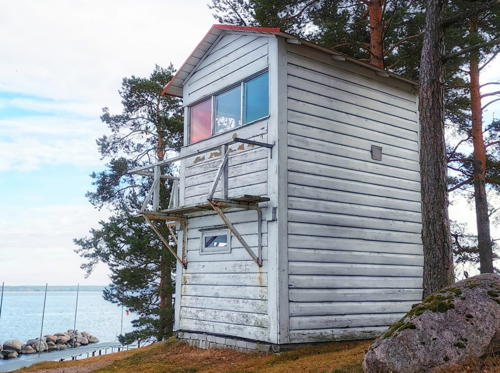
1892. Inactive since the mid 1990s. Approx. 7 m (23 ft) 2-story wood building, painted white; the light was shown through a window. Wikimedia has a photo, Köhler has a 2016 photo, Yuri Zibrin has a 2019 closeup, Oxana Savelyeva has a 2021 closeup, and Michel Forand has a historic postcard view. The little lighthouse is partly obscured by trees in Google's satellite view. This light and the Suurupi Range Front Light (see Northern Estonia) are the only surviving wood lighthouses in Estonia. In 1990, shortly before it was deactivated, the lighthouse had to be moved back from the receding shoreline. In 1998 it was declared to be a protected cultural monument. The lighthouse is only a few steps from the Käsmu Maritime Museum, but it's not known if the lighthouse is managed by the museum. Located just off the beach at Käsmu. Site open, tower closed. . ARLHS EST-086; ex-Admiralty C3870.
* Vergi (3)
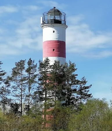
1936 (station established 1917). Active; focal plane 11 m (36 ft); flash every 3 s, white, red, or green depending on direction. 10 m (33 ft) round cylindrical concrete tower with lantern and gallery, painted white; lantern roof is black. Vaarandi's photo is at the top of this page, Trabas has VTA's winter closeup photo, Wikimedia also has Tony Bowden's 2010 closeup, Köhler has a 2016 photo, and Google has a satellite view. The station was established with a small beacon, which was upgraded to a skeletal tower in 1924. The present lighthouse was restored and repainted sometime in recent years. NGA describes the light as being on an island, but apparently the island is now joined to the mainland. Located on the point of Cape Vergi, near the town of Vergi. Site open, tower closed. . ARLHS EST-058; VTA 080; Admiralty C3872; NGA 12920.
Vergi Range Front (2)
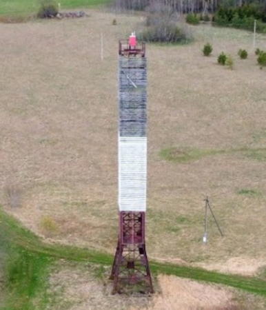
1973 (station established 1935). Inactive since 2003 but maintained as a dayrange. 10 m (33 ft) square cylindrical skeletal tower; the front of the tower carries a slatted daymark painted white with a red vertical stripe. Köhler has a 2016 photo and Google has a distant street view and an indistinct satellite view. Located 1.1 km (0.7 mi) southwest of the Vergi lighthouse. Site status unknown. VTA 085; ex-Admiralty C3873.
Vergi Range Rear (2)
1973 (station established 1935). Inactive since 2003 but maintained as a dayrange. 17 m (56 ft) square cylindrical skeletal tower; the front of the tower carries a slatted daymark painted white with a red vertical stripe. Köhler has a 2016 photo and Bing has an indistinct satellite view. Located 170 m (550 ft) west southwest of the front light. Site status unknown. VTA 086; ex-Admiralty C3873.1.
* Vainupea (Vainupää)
1958. Active; focal plane 24 m (79 ft); white flash every 6 s. 20 m (66 ft) square cylindrical skeletal tower, covered with a white slatted daymark. Trabas has VTA's photo, Köhler has a 2016 photo, and Bing has a satellite view. Located on a headland about 15 km (9 mi) northwest of Kunda. Parking seems to be available next to the light tower, although it is marked as closed in a 2011 street view. Site open, tower closed. VTA 075; Admiralty C3874; NGA 12924.
Vaindloo {Stenskär} (5?)
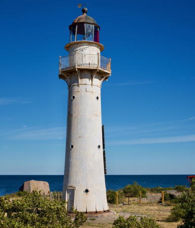
1864 (relocated here in 1871; station established 1718). Active; focal plane 20 m (66 ft); flash every 15 s, white or red depending on direction. 17 m (56 ft) round cast iron tower with lantern and gallery, painted white; lantern dome is red. 1-story crew quarters buildings, stone oil house, and other buildings in a fenced enclosure. Close to the lighthouse is a 50 m (164 ft) skeletal tower used by the Estonian Border Guard. Vaarandi's photo is at right, Trabas has the photo from VTA's page, Harold Biktasev has a closeup, and a distant view is available, but Google has only a fuzzy satellite view. The lighthouse replaced a series of wooden lighthouses, patched and rebuilt many times; the last one collapsed in 1868. This lighthouse was relocated from Vormsi in 1871. It is one of three cast iron lighthouses prefabricated in England for the Russian government of Estonia; the other two are the Kihnu Light, which survives (see Southwestern Estonia), and the first Virtsu Light, now destroyed. The island of Vaindloo, 26 km (16 mi) out in the Gulf of Finland, is the northernmost point of Estonia. The Estonian Border Guard staffs the station as an assertion of Estonian sovereignty. The island is also visited from time to time by birders and researchers. Located on an island about 16 km (10 mi) north of Kunda. Accessible only by boat. Site and tower closed. . ARLHS EST-057; VTA 045; Admiralty C3876; NGA 12928.
Vaindloo Light
Vaindloo Light, July 2005
Wikimedia Creative Commons photo by Sven Vaarandi

Viru-Nigula Parish Lighthouse
* Kunda (2)
1909 (station established 1896). Inactive at least since 1999. Originally this was a 17 m (56 ft) square pyramidal wood tower with lantern and gallery, mounted on a square 1-story limestone base. Only the stone base survives. Google has an indistinct satellite view. The wooden tower was destroyed by fire in the summer of 1999. A historic photo (thumbnail in second row) and Michel Forand's postcard view show its original appearance. In recent years the National Heritage Board has secured the building and added a roof to protect it from further deterioration; perhaps the light tower can be rebuilt in the future. Located near the base of the jetty in Kunda. Site status unknown. Owner/site manager: Muinsuskaitseamet. ARLHS EST-069.
Uhtju (4?)
2000 (station established 1821). Active; focal plane 17.5 m (57 ft); white flash every 4 s. 13 m (43 ft) slender round cylindrical tower carrying a large round lantern structure. The lantern and lower half of the tower are gray metallic; the upper half of the tower is painted red. Trabas has VTA's photo and Bing has a satellite view. Located on a small island, the highest point of a dangerous shoal area, about 25 km (15 mi) north of Kunda. Accessible only by boat. Site open, tower closed. VTA 042; Admiralty C3877; NGA 12935.
* Letipea (3)
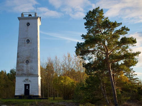
1951 (station established 1815). Reactivated (inactive 1993-95); focal plane 17 m (56 ft); four white flashes every 18 s. 14 m (43 ft) Virtsu-type square concrete tower with gallery but no lantern, mounted on a square concrete block base. Entire lighthouse painted white. A photo by Sven Vaarandi is at right, Koljay Petrov has a closeup photo, Trabas has VTA's photo, and Bing has a satellite view. This light guides ships approaching the port of Kunda. The first lighthouse was privately built and active only briefly in 1815-16. The Estonian Maritime Museum has a historic photo of the concrete tower built here in 1936; it was blown up in 1941 during World War II. From 1995 to 2007 the light was a directional light with white, red and green sectors. Located at the tip of Cape Letipea, about 12 km (7 mi) northeast of Kunda. Site open, tower closed. . ARLHS EST-031; VTA 040; Admiralty C3884; NGA 12940.

Letipea Light, Kunda, May 2006
Wikimedia Creative Commons photo by Sven Vaarandi

Ida-Viru (East Viru) County Lighthouses

Lüganuse Parish Lighthouse
* Moldova
1958. Active; focal plane 85 m (279 ft); white flash every 3 s. 28 m (92 ft) square steel skeletal tower, painted red; the upper 2/3 of the lighthouse is enclosed by a slatted daymark painted black on the upper third of the tower and white in the middle third. Vaarandi has a 2011 photo (seen at the top of this page), Trabas has VTA's photo, and Google has a satellite view. Located on a hill at Moldova, about 10 km (6 mi) west of Kohtla-Järve. Site open, tower closed. ARLHS EST-074; VTA 030; Admiralty C3888; NGA 12944.

Kohtla-Järve Parish Lighthouses
#Valaste (2)
1950s (station established 1928). Inactive since 2006 and demolished sometime in the 2010s. 15 m (49 ft) square cylindrical skeletal tower. Three sides of the tower were covered by a slatted daymark; the upper 2/3 of the daymark were painted red and the lower third white. Vaarandi has a 2012 photo but no tower is seen in Google's satellite view. Formerly located a short distance northeast of the modern tower.
* Valaste (3)
2006 (station established 1928). Active; focal plane 70 m (230 ft); white flash every 2 s. 50 m (164 ft) square cylindrical skeletal communications tower topped by a rectangular platform and a radar antenna. Tower painted in red and white horizontal bands. Trabas has VTA's photo, and Google has a good satellite view and a distant street view. Located just off the beach at Valaste, about 8 km (5 mi) north of Jõhvi. Site open, tower closed. VTA 025; Admiralty C3890; NGA 12948.

Narva-Jõesuu City Lighthouses
Narva (Narva-Jõesuu) (3)
1957 (station established 1725). Active; focal plane 34 m (112 ft); two long (1.5 s) white flashes every 12 s. 30 m (98 ft) round concrete block tower with lantern and gallery, mounted on a 1-story stone base. Tower painted with red and white horizontal bands; lantern painted black; base unpainted gray stone. Fresnel lens in use. A VTA photo is at right, Lighthouse Digest has an older VTA photo, Julia Nikolina has a 2021 photo, Kristjan Lust has a 2023 drone view, Wikimedia has a 2008 photo, Trabas has the photo from VTA's page, and Google has a satellite view. Narva is a historic port city on the frontier between Estonia and Russia. Nothing is known of the 1725 tower but Huelse has a historic postcard view of the 1808 lighthouse, which was destroyed during World War II. Lighthouse located in Narva-Jöesuu, on the west bank at the entrance to the Narva River. Site status uncertain; the area near the mouth of the river is gated but many recent photos indicate the area is open. Tower closed. ARLHS EST-036; VTA 001; Admiralty C3894; NGA 12956.
* Narva-Jõesuu Range Rear (2?)
1954 (station established 1911). Active; focal plane 16.5 m (54 ft); red light, 2 s on, 2 s off. 12 m (39 ft) square cylindrical skeletal tower, painted red. The tower carries a slatted daymark, painted white with a black triangle, point down. Trabas has VTA's photo, Google has a 2023 street view, and Bing has a satellite view. This is an entrance range for the Narva River. The front light is on a similar but shorter tower. Located on the west side of the river in Narva-Jõesuu. Site open, tower closed. VTA 016; Admiralty C3897.1; NGA 12957.1.
Narva Light
Narva Light, Narva-Jõesuu
Estonian Maritime Administration photo

Lake Peipsi (Peipus) Lighthouses

Lake Peipsi (Peipsi Järv or Lake Peipus) is a large lake that occupies more than half of Estonia's eastern border with Russia. The lake drains to the Gulf of Finland through the Narva River. Lake Pihkva, the southernmost section of Lake Peipsi, is connected to the main section by a strait at Mehikoorma. Estonia and Russia have established a joint commission to encourage use of these waterways by pleasure craft. No lighthouses are known on the Russian side of the lake.

Ida-Viru County: Narva City Lighthouse
* Rannapungerja
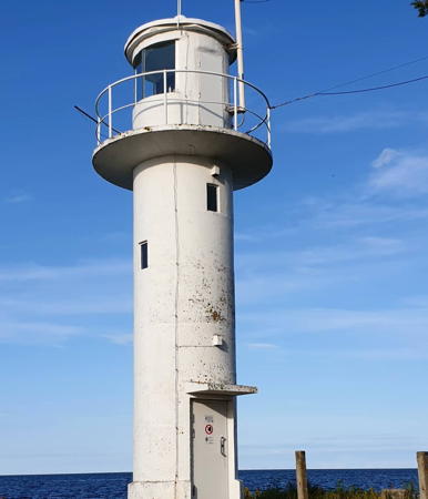
1930s. Active; focal plane about 12 m (39 ft); white flash every 4 s. 8 m (26 ft) round cylindrical concrete tower with lantern and gallery, painted white; lantern roof is black. A photo is at right, Wikimedia has several photos, a 2020 closeup is available, and Google has a distant satellite view. Located at the entrance to the Rannapungerja River on the northwestern shore of the lake. Site open, tower closed. . ARLHS EST-048; VTA P01.

Tartu County: Peipsiääre Parish Lighthouse
* Ninaküla
1938. Active; focal plane about 15 m (49 ft); white flash every 4 s. 10 m (34 ft) round cylindrical concrete tower with lantern and gallery, painted white; lantern roof is black. Kalev Kevad has a photo, Oliver Ojamaa has a photo, Oleg Skrynnik has a night time photo of the lighthouse in action, Wikimedia has several good photos, a 2021 photo is available, and Google has a satellite view. Located on a headland near Nina, in front of an Orthodox church (Nina Õigeusu Kirik), in Peipsiääre Parish about 5 km (3 mi) south of Kallaste on the west side of the lake. Site open, tower closed. . ARLHS EST-037; VTA P12.

Põlva County: Räpina Parish Lighthouse
* Mehikoorma
1930s. Active; focal plane about 20 m (66 ft); white flash every 4 s. 15 m (49 ft) round cylindrical white concrete tower with lantern and gallery. Guy Juton has a good photo, Antti Lauri has a photo, Wikimedia has photos, and Google has a street view and a satellite view. Located on a headland at the narrowest point of the strait connecting Lakes Lämmi and Pihkva about 3 km (2 mi) east of the town of Meeksi. Accessible by road; parking provided. Site open, tower closed. . ARLHS EST-033; VTA P30.

Rannapungerja Light, Lake Peipsi, July 2022
Instagram photo by kt.bilder

Information available on lost lighthouses:

Notable faux lighthouses:

Adjoining pages: North and East: Ingria | West: Northern Estonia

Return to the Lighthouse Directory index | Ratings key

Posted May 1, 2005. Checked and revised July 16, 2023. Lighthouses: 17. Site copyright 2023 Russ Rowlett and the University of North Carolina at Chapel Hill.