Lighthouses of Russia: Ingria

Russia (Россия, Rossiya in Russian) is by far the world's largest country, spanning a little over 150° in longitude. It is organized as the Russian Federation (Rossiyskaya Federatsiya) with members known as federal subjects (sub'yekty federatsii). Russia is primarily a continental nation but it has important coastlines on the Baltic, Black, and Caspian Seas and very long coastlines on the Arctic Ocean and North Pacific Oceans. To guard these coasts it operates hundreds of lighthouses, many of them historic.

The Gulf of Finland, the eastern arm of the Baltic Sea, extends about 425 km (265 mi) to end at St. Petersburg, Russia's traditional western outlet to the sea. For most of its length the Gulf is 60-120 km (38-75 mi) wide. The eastern quarter of the Gulf's length is surrounded by Russian territory and the western 3/4 separates Finland on the north from Estonia on the south. Finland and Estonia were both parts of the Russian Empire before World War I and Estonia was a member republic of the Soviet Union from 1940 until 1991.

The region on the south side of the Gulf between St. Petersburg and the Estonian border is known as Ingria (Inkeri in Finnish, Ingermanland in Swedish). Ingria has been part of Russia since it was conquered by Peter the Great in the early 1700s. Today Ingria represents a large part of Russia's Leningrad Oblast (province), one of the 85 federal subjects. Leningrad Oblast is divided into 17 districts (raions) and one city district (gorodskoy okrug). This page covers the Kingisepp and Lomonosov Districts and the Sosnovy Bor City District.

Curly braces {} are used to enclose former Finnish names of some of the light stations in the Gulf of Finland region that were controlled by Finland between the two world wars.

The Russian word for a lighthouse is mayak (маяк); ostrov is an island, rif is a reef, mys is a cape, bukhta is a bay, zaliv is a larger bay or gulf, proliv is a strait, reka is a river, and gavan' is a harbor.

Russian lighthouses are owned by the Russian Navy and maintained by the Office of Navigation and Oceanography (Управление навигации и океанографии).

ARLHS numbers are from the ARLHS World List of Lights. Admiralty numbers are from volume C of the Admiralty List of Lights & Fog Signals. U.S. NGA List numbers are from Publication 116.

General Sources
Online List of Lights - Russia - Baltic Sea
Photos by various photographers posted by Alexander Trabas. Photos of the Gulf islands lights are by Capt. Peter Mosselberger.
World of Lighthouses - Russia - Baltic Sea and Gulf of Finland
Photos by various photographers available from Lightphotos.net.
Lighthouses in Russia
Photos by various photographers available from Wikimedia.
Russische Leuchttürme auf historischen Postkarten
Postcard views of historic Russian lighthouses posted by Klaus Huelse.
Navionics Charts
Navigation chart for the Gulf of Finland.


Gogland (Pohjoiskorkia) Light, May 2007
Wikimedia Creative Commons photo by Islander

Kingisepp District: Gulf of Finland Islands Lighthouses

Between Finland and Estonia, near the centerline of the Gulf, there is a ragged string of islands that were under Finnish control between World Wars I and II. Occupied by Soviet troops during the Winter War of 1939-40, they were attached to the Russian Federation and remained as Russian possessions after the breakup of the Soviet Union.

Rodsher and Gogland Lighthouses
Gogland (Suursaari in Finnish, Hogland in Swedish, Hochland in German, all names meaning "high island") is the largest of the central Gulf islands and the closest to the Finnish coast. Now without permanent residents, it is the site of a Russian military base with a heliport. Rodsher (Ruuskeri in Finnish), a tiny island about 22 km (14 mi) west southwest of Gogland, is the westernmost point of Russia except for Kaliningrad.

Ostrov Rodsher (2) {Ruuskeri, Rödskär}
1886 (station established 1806). Active; focal plane 20 m (66 ft); two white flashes, separated by 3 s, every 15 s. 19 m (62 ft) octagonal cylindrical concrete tower with lantern and double gallery. The tower is unpainted dark red stone; lantern dome painted dark red to match. 1-story keeper's houses in poor condition. Lightphotos.net has Ilya Tarasov's closeup photo, Viktor Tsarevskiy has additional photos, Qsl.net has two more photos, the Degree Confluence Project has a photo, Trabas has a very distant view, and Bing has a satellite view of the station. The light station is now a research station with half a dozen 1-story buildings. The original wood lighthouse was replaced in 1886 by a round brick tower; this tower was later encased by the current octagonal concrete shell. Accessible only by boat. Site and tower closed. ARLHS ERU-058; Admiralty C3932; NGA 13544.
Severnyy (Northern) Virgin (Ostrova Lensiviri)
Date unknown. Active; focal plane 12.5 m (41 ft); white flash every 4 s. 13 m (43 ft) square pyramidal skeletal tower partially enclosed by a slatted daymark painted red; at the top the tower carries a daymark with 2 balls under a cross. Lightphotos.net has Alexandr Zhukov's closeup photo, Radio amateurs have two photos (third and fourth photos on the page), Trabas has a very distant view, and Google has a distant satellite view. The two Virgin islands are about 12 km (7.5 mi) east of Rodsher and the same distance southwest of Gogland. Located on the northern island. Accessible only by boat. Site status unknown. Admiralty C3934; NGA 13548.
Gogland (Severnyy Goglandskiy) {Suursaari, Pohjoiskorkia, Hogland, Hochland} (5)
1965 (station established 1723). Active (?); focal plane 133 m (436 ft); white light, 3 s on, 4.5 s off. Approx. 17 m (56 ft) round cylindrical concrete block tower with lantern and gallery, painted with red and white horizontal bands. 1-story keeper's house and other light station buildings. A photo is at the top of this page, Zahar Mironov has an excellent 2006 closeup photo, a distant view is available, Lightphotos.net has Alexey Solovev's excellent photo, Trabas has a very distant view, and Google has a satellite view. Peter I had a lighthouse built here in 1723, but it's not known how long that light survived. In 1807 the station was established as a range with lights on short stone towers. In 1861 the rear light was replaced by a keeper's house with a large lantern on the roof; Huelse has a historic postcard view of this lighthouse and a 1931 photo is available. The 1861 lighthouse probably did not survive World War II, when Gogland was a base for Soviet troops. It was replaced after the war by a skeletal tower and then by the masonry lighthouse in 1965. A Russian travel agency has built a hotel on the island and is offering tours from Primorsk. Located atop Pohjoiskorkia, a steep hill at the northern end of the island. Accessible only by boat. Site open, tower closed. ARLHS ERU-056; Admiralty C5374; NGA 13556.
Mys Lounatrivi (Gogland Yuzhny, Hoglands Södra) (3)
1906 (station established 1726). Active; focal plane 27 m (89 ft); white flash every 6 s. 25.5 m (84 ft) round brick tower with lantern and gallery, mounted on a hexagonal stone base. The tower is unpainted red brick with trim painted white. Sergey Gudik's photo is at right, Lightphotos.net has Dmitry Rostopshin's photo, the Degree Confluence Project has a photo of the station, Trabas has a distant photo by Capt. Peter, and Google has a satellite view. This is (or was) a light and research station with half a dozen 1-story buildings, and the lighthouse is dwarfed now by a tall communications tower used as part of the vessel traffic separation scheme for the Gulf. Located at the southern tip of the island. Accessible only by boat; a Russian travel agency has built a hotel on the island and is offering tours from Primorsk. Site and tower closed. ARLHS ERU-020(=213); Admiralty C5378; NGA 13552

Mys Lounatrivi Light, Gogland, August 2016
Google Maps photo by Sergey Gudik

Tyuters Lighthouses
Malyy Tyuters (Little Tyuters) Northwest
Date unknown. Active; focal plane 14 m (46 ft); white flash every 6 s. 8 m (26 ft) square skeletal tower. One side of the tower carries a slatted daymark painted white with a red vertical stripe. A distant view is available (halfway down the page) but the tower is not seen in Google's distant satellite view. Malyy Tyuters is a small island about 25 km (15 mi) south of Gogland. Located at the northwestern tip of the island. Accessible only by boat. Site open, tower closed. Admiralty C3939.4.
Malyy Tyuters (Little Tyuters) Southeast
Date unknown. Active; focal plane 14 m (46 ft); white flash every 6 s. 8 m (26 ft) square skeletal tower. The tower carries a slatted daymark painted white with a red (?) vertical stripe. No photo available and the tower is not seen in Google's distant satellite view. Located at the end of a long spit extending southeastward from the island. Accessible only by boat. Site open, tower closed. Admiralty C3939.42.
Bol'shoy Tyuters (Great Tyuters) {Tytärsaari} (2)
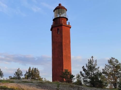
1904. Active; focal plane 75 m (246 ft); white light, 1 s on, 1 s off, 3 s on, 9 s off. 21 m (69 ft) hexagonal brick tower. A photo is at right, Emilia Dzyuba has a good photo, Lightphotos.net has Vladimir Suloev's photo, a 1985 photo is available, and Google has a satellite view. Huelse has a historic postcard view showing the original appearance of the lighthouse. Bol'shoy Tyuters is about 15 km (9 mi) east of Malyy Tyuters and 25 km (15 mi) southeast of Gogland. In 2004 the island was incorporated within the Ingermanlandsky National Nature Reserve, part of an international biosphere reserve developed in cooperation with Finland. The island is dangerous due to unexploded World War II mines; in 2005 Swedish and Russian teams removed over 30,000 mines but it is feared that others may remain. Located on the highest point of the island, about 30 km (19 mi) south of Kotka, Finland, and 80 km (50 mi) west northwest of Kurgolovo, Russia. Accessible only by boat. Site and tower closed. ARLHS ERU-017; Admiralty C3938; NGA 12960.

Bol'shoy Tyuters Light, Bol'shoy Tyuters, August 2021
Google Maps photo

Sommers and Nerva Lighthouses
Sommers (Someri, Sommars, Ostrov Mayak) {Sommarö} (3)
1945 (station established 1808). Active; focal plane 53 m (174 ft); two white flashes every 10 s. 37 m (121 ft) square steel skeletal tower with gallery, painted red; the upper 2/3 of the tower is surrounded by a slatted daymark painted with red and white horizontal bands. Aleksey Krasovsky's photo at right shows the tall radar and communications tower built on the island, Lightphotos.net has Ilya Tarasov's photo, Trabas has a distant photo by Capt. Peter, Swedish Wikipedia has an article on the island with a distant view, and Google has a satellite view. Several keeper's houses and other structures survive at this station. The first two lighthouses were round masonry towers about 9 m (30 ft) tall; the second, built in 1866, was destroyed by Finnish troops at the start of the Winter War in 1939. Sommers is a small island about 12 km (7.5 mi) northwest of Moshchnyy and 18 km (11 mi) south of Hanski on the Finnish coast. The shipping lanes for St. Petersburg and for Vyborg diverge on the east side of the island. Accessible only by boat. Site and tower closed. ARLHS ERU-065; Admiralty C3944; NGA 13276.
Nerva (Ostrov Nerva) (2)
1945 (station established 1867). Active; focal plane 44 m (144 ft); white flash every 8 s. 37 m (121 ft) square steel skeletal tower with gallery, painted red; the upper half of the tower is surrounded by a slatted daymark painted white with a black horizontal band at the top. Lightphotos.net has Alexandr Zhukov's photo and a good view from the sea by Alexey Solovev, Trabas has a distant photo by Capt. Peter, and Bing has a satellite view. Several keeper's houses and other structures survive at this station. This light is a leading light for vessels on the reach between Gogland and Sommers. The original lighthouse was a 28 m (92 ft) round masonry tower; it did not survive World War II. Located on a small island about 18 km (11 mi) east northeast of Sommers. Site and tower closed (landing on the island is forbidden). ARLHS ERU-053; Admiralty C3946; NGA 13272.
Sommers Light
Sommers Light (left) and Traffic Control Tower, July 2010
ex-Panoramio photo by Aleksey Krasovsky

Moshchny Lighthouses
Moshchny (Lavansaari in Finnish and Lövskär in Swedish) is a roughly circular island about 4 km (2.5 mi) in diameter and about 20 km (13 mi) northwest of Kurgolovo.

Vigrund
Date unknown. Active; focal plane 22 m (72 ft); white flash every 5 s. 20 m (66 ft) square pyramidal skeletal tower, painted red. Mikhail Pozdnyakov has a 2010 photo and Bing has a satellite view. Located on a small island about 25 km (15 mi) southwest of Moschnyy. Accessible only by boat. Site status unknown. ARLHS ERU-230; Admiralty C3940; NGA 12964.
Moshchny (Moschny, Bashnya) {Lavensaari}
1910. Active; focal plane 30 m (98 ft); three white flashes every 10 s. 29 m (95 ft) hexagonal cast iron skeletal tower with lantern and gallery, painted red; lantern dome painted white. Wikimapia's photo is at right and Lightphotos.net has Ilya Tarasov's closeup photo but the tower is not seen in Google's distant satellite view. Located on the northern tip of the island. Accessible only by boat. Site and tower closed. ARLHS ERU-154; Admiralty C3952; NGA 13280.
Ostrov Moshchny Range Front
Date unknown. Active; focal plane 20 m (66 ft); white light, 1.5 s on, 1.5 s off. 19 m (62 ft) square concrete tower, painted white with a black vertical stripe on the range line. Lightphotos.net has Ilya Tarasov's closeup photo, Wikimapia has a photo, and Bing has a satellite view. Located on the northeast side of the island. Accessible only by boat. Site and tower closed. Admiralty C3954.
Ostrov Moshchny Range Rear
Date unknown. Active; focal plane 34 m (112 ft); white light, 1.5 s on, 1.5 s off. 29 m (95 ft) square concrete tower, painted red; the tower also carries a rectangular daymark painted white with a black vertical stripe on the range line. This tower is in the background of an Ilya Tarasov photo of the front light and Bing has an indistinct satellite view. Located 415 m (1/4 mi) behind the front light. Accessible only by boat. Site and tower closed. Admiralty C3954.1.
Promezhutochny Range Front
Date unknown. Active; focal plane 20 m (66 ft); quick-flashing white light. 16 m (52 ft) square skeletal tower, painted red; the tower also carries a rectangular daymark painted white with a black vertical stripe on the range line. No photo available and shadow hides the tower in Bing's satellite view. Located on the east side of Ostrov Moshchny. Accessible only by boat. Site and tower closed. Admiralty C3958.

Moshchnyy Light
Wikimapia Creative Commons photo
Promezhutochny Range Rear
Date unknown. Active; focal plane 35 m (115 ft); white light, 2 s on, 2 s off. 26 m (82 ft) square skeletal tower, painted red; the tower also carries a rectangular daymark painted white with a black vertical stripe on the range line. No photo available but Bing has an indistinct satellite view. Located 410 m (1/4 mi) behind the front light. Accessible only by boat. Site and tower closed. Admiralty C3958.1.
Ostrov Malyy
Date unknown. Active; focal plane 37 m (121 ft); white light, 2 s on, 4 s off. 27 m (89 ft) skeletal tower, painted red. The tower carries a slatted daymark painted white with a red vertical stripe. No photo available and the tower is not seen in Google's distant satellite view. Mikhail Pozdnyakov has a photo of the view from atop the tower. Ostrov Malyy is a small island about 8 km (5 mi) due east of Moshchny. Located on the highest point of the island. Accessible only by boat. Site and tower closed. ARLHS ERU-219; Admiralty C3964; NGA 13284.

Seskar Lighthouses
Easternmost of the Gulf of Finland islands, Seskar (Seiskari in Finnish) once had a Finnish community of more than 800 residents, but it is now uninhabited.

Seskar {Seiskari} (3)
1858 (station established in the 1600s). Active; focal plane 30 m (98 ft); two white flashes, separated by 6.5 s, every 30 s. 31 m (101 ft) round tower with lantern and gallery, painted red with a broad white horizontal band covering most of the lower half. A large clamshell Fresnel lens is in use. The keepers houses were occupied by keepers as of 1998. Matvey Churakov's photo is at right, Lightphotos.net has Vladimir Suloev's closeup photo and an aerial view, Marina Mokshina has a closeup, Trabas has a photo of the light in action, Huelse has a historic postcard view, and Google has a satellite view of the station. Sweden built a lighthouse here in the 17th century; Russia replaced it with a brick tower in 1807 before building the present lighthouse in 1858. The status of this site is unclear; Pete Amass visited the station and climbed the tower in 1998 but there is a 2004 report that the island has only recently been opened to foreign visitors. Located on the northwestern point of Ostrov Lesnoy, the main island of the Seskar island group, about 16 km (10 mi) northwest of Mys (Cape) Kolgampja. Accessible only by boat. Site status unknown. ARLHS ERU-005; Admiralty C3968; NGA 13288.
Seskar South (Pen-Kheta-Stor)
Date unknown. Active; focal plane 26 m (85 ft); two white flashes every 4 s. 24 m (79 ft) square skeletal tower, painted red. The upper 2/3 of the tower is enclosed with a slatted daymark painted white with red vertical stripes. Andrey Chemizov has a closeup photo, Trabas has a photo, Wikimapia has a view from the sea (fourth photo in the row), and Google has a satellite view. Located on the southeastern tip of Ostrov Lesnoy. Accessible only by boat. Site status unknown. ARLHS ERU-223; Admiralty C3972; NGA 13292.

Seskar Light, January 2022
Google Maps photo by Matvey Churakov

Kingisepp District: Mainland Lighthouses

Kurgalsky Peninsula Lighthouses
The blunt Kurgalsky Peninsula projects about 15 km (9 mi) into the Gulf of Finland, separating Narva Bay on the west from Luzhskaya (Luga) Bay to the east.
Kaybolovo (Kaibolovo)
Date unknown. Active; focal plane 61 m (20 ft); white light, 4 s on, 4 s off. 37 m (121 ft) square cylindrical skeletal tower, the top half covered by a slatted daymark. Tower painted black, daymark white. A photo is available and Google has a satellite view. In 2003 thieves broke into the lighthouse to steal non-ferrous metals. They discarded the radioisotope thermoelectric generator (RTG) that powered the lighthouse, creating a serious case of radioactive pollution. (Soviet-era RTG's were powered by highly radioactive strontium 90, and the presence of these increasingly dilapidated and dangerous power units in unattended lighthouses was and is a matter of grave international concern.) Located about 7 km (4 mi) southwest of Kurgolovo. Site status unknown. ARLHS ERU-139; Admiralty C3918; NGA 12972.
* Mys Pikhlisaar
Date unknown. Active; focal plane 29 m (95 ft); white flash every 4 s. 25 m (82 ft) square cylindrical skeletal tower, the top half covered by a slatted daymark. Tower painted red, daymark white. Wikimapia's photo is at right, Sergey Kanzuba has a 2018 photo, Juhann Uspäivä has another photo, and Bing has an indistinct satellite view. Like Kaybolovo, this lighthouse was stripped by vandals who dumped the RTG in the Gulf of Finland. Located on Cape Pikhlisaar, marking the western entrance to the Luzhskaya bay about 6 km (3.5 mi) east of Kurgolovo. Site open, and apparently nothing prevents vistors from climbing the tower. ARLHS ERU-142; Admiralty C3976; NGA 12984.
Mys Luto
Date unknown. Active; focal plane 25 m (82 ft); white flash every 3 s. 21 m (69 ft) square cylindrical skeletal tower, the top half covered by a slatted daymark. Tower painted red, daymark white with a black vertical stripe. No closeup photo available but Google has a good satellite view. There is a very distant view of the tower at 0:10 in a short video by Yuri Litvinovich. Located on a promontory near the middle of the west side of Luzhskaya bay. Site status unknown. Admiralty C3977; NGA 12985.
Pustoshskiy Range Front
Date unknown. Active; focal plane 13 m (43 ft); quick-flashing white light. 12 m (39 ft) skeletal tower with gallery; the tower carries a rectangular daymark painted white with a black vertical stripe. No photo available but Bing has a satellite view. This range guides ships bound for Ust-Luga around a shoal in the center of Luga Bay. Located at the southwestern corner of Luzhskaya bay. Site status unknown. Admiralty C3978.
Pustoshskiy Range Rear
Date unknown. Active; focal plane 26 m (85 ft); white light occulting once every 3.5 s. 15 m (49 ft) skeletal tower with gallery; the tower carries a rectangular daymark painted white with a black vertical stripe. Google has a street view and a satellite view. Located 340 m (372 ft) west of the front light. Site status unknown. Admiralty C3978.1.
Mys Pikhlisaar Light
Mys Pikhlisaar Light, Kurgolovo
Wikimapia Creative Commons photo

Ust-Luga Lighthouses
Ust-Luga is a town on the east side of the mouth of the Luga River where it flows into the south end of Luga Bay. The river is navigable as far as the district capital of Kingisepp.

Ust'Luzhskiy Rechnoy Range Front
Date unknown. Active; focal plane about 15 m (49 ft); green light, pattern unknown. Approx. 12 m (39 ft) tower. A photo is available and Google has a satellite view. This the entrance range for the Luga River. Located on the waterfront within the port complex. Site and tower closed. Admiralty C3978.5.
Ust'Luzhskiy Rechnoy Range Rear
Date unknown. Active; focal plane about 26 m (85 ft); green light, pattern unknown. Approx. 23 m (75 ft) round cylindrical concrete tower. Google has a street view and a satellite view. Located about 400 m (1/4 mi) southwest of the front light just outside the harbor area. Site appears open, tower closed. Admiralty C3978.6.
Ust'Luzhskiy Morskoy Range Front (2?)
Date unknown. Active; focal plane about 18 m (59 ft); white light, pattern unknown. Approx. 12 m (39 ft) tower. No photo available but Google has a satellite view. This is the approach range for the Luga River. Google also has a satellite view of a similar structure about 125 m (410 ft) to the west; this may be an earlier range light. Navionics charts all four towers with white lights. Located in a forested area east of the river's mouth. Site status unknown. Admiralty C3979.5.
Ust'Luzhskiy Morskoy Range Rear (2?)
Date unknown. Active; focal plane about 30 m (98 ft); white light, pattern unknown. Approx. 12 m (39 ft) tower. No photo available but Google has a satellite view. Google also has a satellite view of a similar structure about 200 m (650 ft) to the northwest; this may be an earlier range light. Located about 400 m (1/4 mi) south of the front light. Site status unknown. Admiralty C3979.6.
Morskogo Kanala Porta (Luzhskiy Morskoy) Range Front
Around 1999. Active; focal plane about 25 m (82 ft); red flash every 1.5 s. Approx. 22 m (72 ft) triangular skeletal tower; the front face carries a slatted daymark painted red with a broad white vertical stripe. Google has a distant street view and a satellite view. The Ust-Luga Port was developed beginning in 1997 as a terminal for bulk commodities such as coal and fertilizer formerly shipped to Baltic ports through what is now Belarus and Lithuania. Located in the middle of the port area. This is the entrance range for the port. Site status unknown. Admiralty C3981; NGA 12986.
Morskogo Kanala Porta (Luzhskiy Morskoy) Range Rear (2)
2019 (?) (station established around 1999). Active; focal plane about 45 m (148 ft); red light occulting once every 3 s. Approx. 40 m (121 ft) triangular skeletal tower; the front face carries a slatted daymark painted red with a broad white vertical stripe. Around 2019 a new tower was built 160 m (525 ft) south of the original. Google has a satellite view of the new light and a 2013 street view (seen at right) of the earlier light. Located about 860 m (0.53 mi) south of the front light. Site status unknown. Admiralty C3981.1; NGA 12987.

Morskogo Kanala Porta Range Rear Light, Ust-Luga, June 2013
Google Maps street view

Soikinsky Peninsula Lighthouses
The wedge-shaped Soikinsky Peninsula projects about 25 km (15 mi) into the Gulf of Finland, separating Luzhskaya (Luga) Bay on the west from Koporye Bay on the east.

Yugantovskiy Range Front
2012. Active; focal plane 44 m (144 ft); red flash every 1.5 s. 42 m (138 ft) square skeletal tower carrying rectangular daymark painted white with a black vertical stripe. No photo available but Google has a satellite view and a distant street view. This is an approach range guiding vessels across Luga Bay to the Ust-Luga port. Located in a densely forested area on the east side of Luzhskaya Bay. Site status unknown. Admiralty C3982.1; NGA 12987.8.
Yugantovskiy Range Rear
2012. Active; focal plane 68 m (223 ft); red flash every 1.5 s. 67 m (220 ft) square skeletal tower carrying rectangular daymark painted white with a black vertical stripe. Google has a street view and a satellite view. Located at a facility of unknown nature about 800 m (1/2 mi) east southeast of the front light.. Site status unknown. Admiralty C3982.2; NGA 12987.81.
Vistinskiy
Date unknown. Active (?); focal plane about 15 m (49 ft); red light, pattern unknown. Approx. 12 m (39 ft) round white tower; the upper portion is surrounded by a white cylindrical daymark. No photo available but Bing has a satellite view. This light has been dropped from the Admiralty list. Located on a promontory near Vistino. Site status unknown. ex-Admiralty C3984.
Novaya Gavan' Ruch'i Range Front
Date unknown. Active; focal plane about 14 m (46 ft); red light, pattern unknown. Approx. 13 m (43 ft) skeletal tower carrying a daymark painted orange with a white vertical stripe. No photo available but Bing has a satellite view. The range guides ships to a new harbor (novaya gavan') at Vistino. Site status unknown. Admiralty C3985.
Novaya Gavan' Ruch'i Range Rear
Date unknown. Active; focal plane 18 m (59 ft); red light, 2.5 s on, 2.5 s off. 18 m (39 ft) skeletal tower carrying a daymark painted orange with a white vertical stripe. Google has a distant street view and Bing has a satellite view. Located about 125 m (400 ft) east of the front light. Site status unknown. Admiralty C3985.1.
Gorki (Gorky)
Date unknown. Active; focal plane 181 m (594 ft); white light, 3 s on, 3 s off. 41 m (135 ft) round tower with a large round control room and other facilities, rising from a substantial building. Tower painted with red and white horizontal bands. Google has a street view and the shadow of the tower is conspicuous in a Google satellite view. This tower is a vessel tracking tower of the Automated Identification System. Located north of Vistino on the east side of the Luzhskaya bay, about 10 km (6 mi) south southwest of Cape Kolgampya. Site status unknown, probably closed. ARLHS ERU-138; Admiralty C3986; NGA 12988.
Mys Kolganpya (Kolgampya, Kolgompya) Range Front
Date unknown. Active; focal plane 24 m (79 ft); quick-flashing white light. 21 m (69 ft) square cylindrical skeletal tower, the top half covered by a slatted daymark. Daymark painted white with a red vertical stripe. A photo is at right, Lightphotos.net has the same photo, Sergey Babushkin has a photo, and Bing has a satellite view. The range guides vessels approaching the Luga Bay ports from the east. Located on the tip of Mys Kolganpya, the prominent cape at the northern end of the Soikinsky Peninsula. Site status unknown. ARLHS ERU-076; Admiralty C3988; NGA 12992.
Mys Kolganpya (Kolgampya, Kolgompya) Range Rear
Date unknown. Active; focal plane 31 m (102 ft); white light, 2 s on, 2 s off, visible only on the range line. 15 m (49 ft) square pyramidal skeletal tower, painted white. The north side of the tower carries a large slatted daymark painted white with a black vertical stripe. No photo available, but Bing has a distant satellite view. Located about 1.2 km (3/4 mi) south of the front light and the cape. Site status unknown. Admiralty C3988.1; NGA 12996.

Mys Kolganpya Range Front Light, Krivoruch'ye, August 2016
ex-Google Maps photo by Vyuga

Sosnovy Bor City Lighthouse

#Mys Ustinskiy (Sosnovy Bor)
Date unknown. Inactive. This was a 29 m (95 ft) square cylindrical skeletal tower, the upper half covered on all sides by a slatted daymark. No photo available and Google's satellite view shows that the tower has been removed. Sosnovy Bor ("Pine Forest") is a new town built in connection with a large nuclear power plant but now also the site of a number of research institutes. Formerly located on Mys Ustinskiy, a sharp cape marking the eastern entrance to Koporye Bay, about 8 km (5 mi) west of Sosnovy Bor. Site open, tower closed. ARLHS ERU-143; ex-Admiralty C3996.

Lomonosov District Lighthouses

* Mys Shepelevskiy (Shepelevsky)
1910. Active; focal plane 37 m (121 ft); two long white flashes every 16 s, white or red depending on direction. 36 m (118 ft) round cast iron tower with lantern and gallery. Tower painted with horizontal red and white bands; gallery painted black. Keeper's house and other light station buildings. Near the lighthouse is a new communications tower, more than twice the height of the lighthouse, also painted with horizontal red and white bands. A photo is at right, Trabas has a photo, Sergey Nelinov has an early spring photo, Wikimapia has several photos, and Google has a street view and a satellite view. This lighthouse was prefabricated in France. It is an important light station guarding the south side of the entrance to the Gulf of Kronstadt, the narrow extension of the Gulf of Finland leading to St. Petersburg. Located on the headland of Mys (Cape) Shepelevskiy about 60 km (37.5 mi) west of St. Petersburg and 30 km (19 mi) west of Lomonosov. Accessible by road but some local guidance may be needed to find the entrance. Site open, tower closed unless the keeper can be persuaded to give a tour. . ARLHS ERU-007; Admiralty C4004; NGA 13004.
* Krasnaya Gorka Common Range Rear (2)
1957 (station established before 1950). Active; focal plane 60 m (197 ft); white light, 1.5 s on, 1.5 s off. 38 m (125 ft) square cylindrical steel skeletal tower with lantern and gallery. Fresnel lens in use. Lighthouse painted red; the upper half of the tower is enclosed by a slatted daymark painted with red and white vertical stripes. 1-story wood service building, painted white. Trabas has a distant view and Bing has a satellite view. The light is about 1.6 km (1 mi) east of the historic Krasnaya Gorka fortress. Founded by Peter the Great, the fortress was the location of Russia's first lighthouse in 1721. Located on the south shore of the Gulf of Finland on the west side of Lebyazhye and about 20 km (13 mi) west of Lomonosov. Site open, tower closed. ARLHS ERU-141; Admiralty C4006; NGA 13008.
* Krasnaya Gorka 212° Range Front
Date unknown. Active; focal plane 37 m (121 ft); continuous red light. Approx. 20 m (66 ft) robust post light carrying a large drum-shaped daymark. Tower painted white, daymark red with a white vertical stripe on the apparent range line. Yuri Tupitsin has a street view, Trabas has a photo, and Google has a satellite view. The Krasnaya Gorka Ranges are described as a "deviation range." Located beside the coastal highway on the west side of Lebyazhye, about 335 m (1100 ft) north northwest of the Krasnaya Gorka lighthouse. Site open, tower closed. Admiralty C4005.9.
* Krasnaya Gorka 220° Range Front
Date unknown. Active; focal plane 37 m (121 ft); continuous red light. Approx. 20 m (66 ft) robust post light carrying a large drum-shaped daymark. Tower painted white, daymark red with a white vertical stripe on the apparent range line. Trabas has a photo and Google has a street view and a satellite view. Located on the same road about 80 m (90 ft) east of the 212° front light. Site open, tower closed. Admiralty C4006.1

Mys Shepelevskiy Light, Lomonsov, June 2021
Google Maps photo by Larisa I

Information available on lost lighthouses:

Notable faux lighthouses:

Adjoining pages: North: Southern Finland | East: St. Petersburg | Southwest: Northern Estonia

Return to the Lighthouse Directory index | Ratings key

Posted May 22, 2005. Checked and revised July 23, 2023. Lighthouses: 42. Site copyright 2023 Russ Rowlett and the University of North Carolina at Chapel Hill.