Lighthouses of Southwest Finland

The Republic of Finland (Suomi in Finnish) is a country of northern Europe with coastlines facing south on the Gulf of Finland (Suomenlahti) and west on the Gulf of Bothnia (Pohjanlahti), both arms of the Baltic Sea. Finland also administers the Åland Islands (Ahvenanmaa), an archipelago at the junction of the two gulfs. After centuries of rule by Sweden, Finland was conquered by Russia in 1809 and became an autonomous grand duchy within the Russian Empire. The country declared its independence from Russia at the start of the Russian Revolution in 1917. It lost some of its eastern territory to Russia as a result of World War II but has retained its independence.

Finland is divided into nineteen regions (maakunta) and the regions are divided into municipalities. This page includes the lighthouses of the Southwest Finland (Varsinais-Suomi, "Finland Proper") Region, located at the southwestern tip of Finland. The region is called "Finland Proper" because it is the original home of the Finnish people. Much of the region faces the Archipelago Sea (Skärgardshavet in Swedish, Saaristomeri in Finnish): the islands-strewn sea between the mainland and the Åland Islands.

The Finnish word for a lighthouse is majakka (plural majakat). Saari is an island, luoto is an islet or skerry, niemi is a cape or headland, niemimaa is a peninsula, lahti is a bay, salmi is a strait, joki is a river, and satama is a port or harbor. Swedish is a second official language in Finland and some of the lighthouses are commonly known by their Swedish names.

Lighthouses in Finland are maintained by the Waterways Section of the Finnish Transport Infrastructure Agency (Liikennevirasto).

ARLHS numbers are from the ARLHS World List of Lights. SU numbers are from the official Finnish light list. Admiralty numbers are from volume C of the Admiralty List of Lights & Fog Signals. U.S. NGA List numbers are from Publication 116. However, NGA has no listings for lights of the Archipelago Sea.

General Sources
Online List of Lights - Finland
Photos by various photographers posted by Alexander Trabas. Many photos from this area are by Klaus Kern.
Finskt fyrväsende
Photos and information posted by the Swedish Lighthouse Society.
Finnish Lighthouses
Excellent photos of the some of the better known lighthouses, posted to Flickr by Mikko Rauhala.
Lighthouses in Finland
Photos by various photographers available from Wikimedia.
World of Lighthouses - Finland
Photos by various photographers available from Lightphotos.net.
Lighthouses in Finland
Aerial photos posted by Marinas.com.
Weitere Europäische Leuchttürme auf historischen Postkarten
Historic postcard images posted by Klaus Huelse.
List of Lights
The Finnish light list is available for download.
Finnish Lighthouse Society
The national lighthouse preservation association.
GPSNauticalCharts
Navigational chart information for southwestern Finland.
Navionics Charts
Navigational chart for southern Finland.


Bengtskär Light, Gulf of Finland, July 2009
Wikimedia Creative Commons photo
by Pöllö
Bengtskär Lighthouse
**** Bengtskär
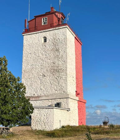
1906 (Florentin Granholm). Active; focal plane 51 m (167 ft); three white flashes every 20 s. 46 m (151 ft) round granite tower with lantern and gallery, attached to one end of a 3-1/2 story granite keeper's house. The lighthouse is unpainted; lantern dome is greenish metallic. Clamshell Fresnel lens in use. A photo appears at the top of this page, Trabas has an excellent photo by Kern, Wikimedia has a large portfolio of photos, Rauhala also has a good photo, Finnish Wikipedia has a page with a photo and historical information, Sebastiaan Jonckheere has a 2017 street view, and Google has a satellite view. This lighthouse, the tallest Finnish lighthouse and one of Finland's best known lighthouses, was built after the steamship Helsingfors wrecked nearby in 1905. The light marks the north side of the entrance to the Gulf of Finland from the Baltic Sea. It is also marks the southernmost inhabited land in Finland. The lighthouse was shelled by German ships during World War I but was not badly damaged. In World War II Soviet troops attempted to storm the island on 26 July 1941, but they were driven off after a fierce battle. Soviet air raids damaged the keeper's house but spared the tower. After repairs the lighthouse was reactivated in 1950. Automated in 1968, the lighthouse gradually deteriorated and it was in poor condition by 1985, when it was leased to the Pro Bengtskär Association. When the Association failed to raise sufficient funds for a restoration the lease was transferred to the Centre of Extension Studies of the University of Turku. Restored in the early 1990s, the lighthouse now includes overnight accommodations, a lecture hall, conference rooms, a café, museum, and post office. Located on a small island about 25 km (15 mi) west southwest of Hanko. Passenger ferry service to the lighthouse is available from Kasnäs in the Åland Islands. Site open, lighthouse and tower open daily June 1 through August 31. Site manager: University of Turku. . ARLHS FIN-001; SU-11475; Admiralty C4906; NGA 15268.

Kimitoön Lighthouse
Fjärdskär
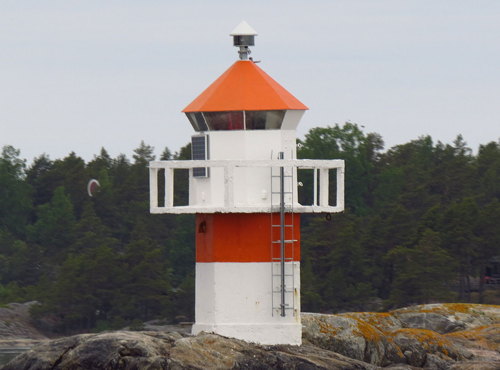
Date unknown. Active; focal plane 5 m (17 ft); flash every 3 s, white, red or green depending on direction. 5 m (17 ft) octagonal cylindrical concrete tower with lantern and gallery, painted white with one red horizontal band; lantern roof is red. Trabas has Darlene Chisholm's photo (also seen at right) and Google has a satellite view. This light guides vessels in an east-west channel through a maze of islands. Located on a rock off the south coast of Fjärdskär. Accessible only by boat. Site open, tower closed. SU-3450; Admiralty C4746.2; NGA 15508.

Pargas Area Lighthouses
These lights guide vessels in a narrow channel through the islands southwest of the town of Pargas.

Svartholm
Date unknown. Active; focal plane 6 m (20 ft); flashing light, white, red or green depending on direction. 6 m (20 ft) concrete tower with lantern and gallery, painted white and mounted on an octagonal concrete pier. Trabas has a photo and Google has a satellite view. Located off the east side of Svartholmen. Accessible only by boat. Site open, tower closed. SU-3531; Admiralty C4833.
Kärrholm
Date unknown. Active; focal plane 6 m (20 ft); flashing light, white, red or green depending on direction. 6 m (20 ft) concrete tower with lantern and gallery, mounted on an octagonal concrete pier. Tower painted red, lantern white with a red roof. Trabas has a photo and Google has a satellite view. Located off the south side of Stora Bässholmen. Accessible only by boat. Site open, tower closed. SU-3530; Admiralty C4830.

Fjärdskär Light, Kimitoön
photo copyright Darlene Chisholm; used by permission
Prostvikkalven (Prostvikskalven)
Date unknown. Active; focal plane about 10 m (33 ft); flashing light, white, red or green depending on direction. Approx. 6 m (20 ft) stone tower with lantern and gallery; lantern painted white. Trabas has a photo, Wikimedia also has a photo, and Google has a satellite view. Located at the northeastern tip of an island off the northeastern tip of the large island of Lillandet. Site status unknown. Site open, tower closed. SU-3373; Admiralty C4829.

Utö Lighthouses
Utö is a small island about 60 km (37.5 mi) southwest of Turku; it is the southernmost island in what is known in Finland as the Archipelago Sea (Saaristomeri), a maze of islands between the mainland and the Åland Islands. The permanent population on the island is about 40.

Lillharun
Date unknown. Active; focal plane 17 m (56 ft); flash every 7 s, white, red or green depending on direction. 12 m (39 ft) round cylindrical concrete tower with lantern and gallery, painted black; lantern painted white. A photo is available but Google has only a fuzzy satellite view of the skerry. Located on a reef about 6.5 km (4 mi) south southeast of Utö. Accessible only by boat. Site open, tower closed. SU-3296; Admiralty C4732; NGA 15780.
* Utö (2)
1814 (station established 1753). Active; focal plane 40 m (131 ft); two white flashes every 12 s. 24 m (79 ft) square granite tower with lantern and gallery. Lighthouse painted with red and white vertical stripes; lantern painted red; lantern dome is greenish metallic. Merja Laitervo's photo is at right, Rauhala has a good photo, Trabas has Kern's photo, Wikimedia has a portfolio of photos, Finnish Wikipedia has a page with a photo and historical information, Markus Kartano has a street view, and Bing has a satellite view. The first lighthouse on the island was destroyed during the Russian-Swedish War in 1808. As the most substantial building on the island, the present lighthouse served as a church and town hall for the islanders during the mid nineteenth century. Like Bengtskär, the lighthouse was shelled by German ships during World War I but not badly damaged. A Soviet raid on the island was repulsed during the Winter War of 1939. Located on the highest point of the island. Site open, tower closed. . ARLHS FIN-090; SU-3187; Admiralty C4736; NGA 15800.
Utö Sector
Date unknown. Active; focal plane 13 m (43 ft); quick-flashing light, white, red, green or yellow depending on direction. 6 m (20 ft) lantern on a platform supported by piles. Next to this light is a square skeletal tower carrying a quick-flashing yellow range light. Lightphotos.net has a photo and Bing has a satellite view. Located on the western tip of Utö. Site open, tower closed. SU-20125; Admiralty C4734; NGA 15808.
Bokullankivi
Date unknown (station established 1958). Active; focal plane 9 m (30 ft); flash every 5 s, white, red or green depending on direction. 9 m (30 ft) round cylindrical concrete tower with lantern and gallery, painted white with one black horizontal band. Trabas has Kern's photo and Google has a satellite view. Located on a shoal about 8 km (5 mi) north northeast of Utö. Accessible only by boat. Site open, tower closed. SU-3205; Admiralty C4743.2; NGA 15860.

Utö Light, Utö, July 2023
Instagram photo
by Merja Laitervo

Turku Southern Approach Lighthouses
Lights in this group guide vessels approaching Turku on a channel from the south that begins near Utö.

Norparskärssten
Date unknown. Active; focal plane 10 m (33 ft); flashing light, white, red or green depending on direction. 10 m (33 ft) tower painted with black and white horizontal bands and mounted on a round concrete pier. No photo available but Google has a satellite view. Located about 30 km (19 mi) northeast of Utö. Site open, tower closed. SU-3605; Admiralty C4765.2.
Flatö Range Rear
Date unknown. Active; focal plane 29.5 m (100 ft); long white flash every 6 s. Approx. 25 m (82 ft) square skeletal mast carrying a large rectangular daymark colored red with a yellow vertical stripe. Trabas has Kern's photo and Google has a satellite view. Located on the northeastern corner of the island of Flatö. Site status unknown. SU-3517; Admiralty C4766.48.
Nötö Range Rear
Date unknown. Active; focal plane 35 m (115 ft); long white flash every 8 s. Approx. 25 m (82 ft) square skeletal mast carrying a large rectangular daymark colored red with a yellow vertical stripe. Trabas has Kern's photo and Google has a satellite view. Located on the northwest coast of the island of Nötö. Site status unknown. SU-3208; Admiralty C4765.61.
Bondsten
Date unknown. Active; focal plane 7 m (23 ft); white, red or green light depending on direction, occulting twice every 6 s. 6 m (20 ft) round cylindrical concrete tower with lantern and gallery painted with black and white horizontal bands. Trabas has Kern's photo and Google has a satellite view. Located on a skerry on the east side of the ship channel about 5 km (3 mi) northwest of Nötö. Accessible only by boat. Site open, tower closed. SU-3213; Admiralty C4766.6.
Lång Ljusskär
Date unknown. Active; focal plane 7 m (23 ft); flashing light, white, red or green depending on direction. 5 m (17 ft) square concrete tower with lantern and gallery. Tower painted black, lantern white. Trabas has Kern's photo and Google has a satellite view. Located on a skerry on the east side of the ship channel about 4 km (2.5 mi) north of the Bondsten lighthouse. Accessible only by boat. Site open, tower closed. SU-3580; Admiralty C4767.3.
Kalvholm
Date unknown. Active; focal plane 7 m (23 ft); white, red or green light depending on direction, occulting twice every 6 s. 7 m (23 ft) square concrete tower with lantern and gallery. Tower painted orange, lantern white. Trabas has Kern's photo and Google has a satellite view. Located on an island on the west side of the ship channel south of Lohm. Accessible only by boat. Site open, tower closed. SU-3581; Admiralty C4767.7.
Fagerholm (Range Front)
Date unknown. Active; focal plane 7 m (23 ft); quick-flashing light, white, red or green depending on direction. 6 m (20 ft) square concrete tower with lantern and gallery. Entire lighthouse painted white. A daymark panel colored yellow with an orange vertical stripe stands next to the lighthouse. Trabas has Kern's photo, Markku Miettinen has a distant view from the sea, and Google has a satellite view. This light marks a sharp bend in the channel. Located on an island on the east side of the ship channel off the east end of Ängsö. Accessible only by boat. Site open, tower closed. SU-3218; Admiralty C4768.
Tärngrund (Range Front)
Date unknown. Active; focal plane 6 m (20 ft); quick-flashing light, white, red or green depending on direction. 6 m (20 ft) square concrete tower with lantern and gallery. Entire lighthouse painted white. Jukka Lukkari has a view from the sea (a portion is seen at right) and Google has a satellite view. Located on a skerry off the northwest corner of Killingholm, about 1.6 km (1 mi) west of the Fagerholm lighthouse. Accessible only by boat. Site open, tower closed. SU-3582; Admiralty C4770.
Holstanäs (2?)
Date unknown. Active; focal plane 8 m (26 ft); flash every 3 s, white, red or green depending on direction. 5 m (17 ft) square concrete tower with lantern and gallery. Entire lighthouse painted white. A daymark panel colored yellow with an orange vertical stripe stands next to the lighthouse. Trabas has Kern's photo, a view from the sea is available, and Google has a satellite view. Located on a headland on the southeast side of Korpo. Site status unknown. SU-3222; Admiralty C4773.
 

Tärngrund Light, Archipelago Sea, June 2015
Google Maps photo
by Jukka Lukkari
 
Lydarudd Range Rear
Date unknown. Active; focal plane 21 m (69 ft); long white flash every 6 s. Approx. 25 m (82 ft) square skeletal tower carrying a large rectangular daymark colored red with a yellow vertical stripe. Trabas has a photo and Google has a satellite view. The range guides southbound vessels. Located at the water's edge on the west side of Storlandet. Site status unknown. SU-3227; Admiralty C4777.41.
Vandrock Range Front
Date unknown. Active; focal plane 27 m (89 ft); quick-flashing white light. Approx. 30 m (98 ft) square skeletal tower carrying a large rectangular daymark colored red with a yellow vertical stripe. Trabas has a photo and Google has a satellite view. The range guides northbound vessels. Located at the water's edge on the west side of Vandrock. Site status unknown. SU-3584; Admiralty C4777.2.
Vandrock Range Rear
Date unknown. Active; focal plane 35.5 m (117 ft); long white flash every 6 s. Approx. 20 m (66 ft) square skeletal tower carrying a radar antenna and a large rectangular daymark colored red with a yellow vertical stripe. Trabas has a photo and Google has a satellite view. Located on Vandrock about 500 m (0.3 mi) north northeast of the front light. Site status unknown. SU-3606; Admiralty C4777.21.

Turku Approach Lighthouses
Turku (formerly called Åbo under Swedish rule) is an important seaport and the capital of the Southwest Finland region. Ferries arrive here from Stockholm and Kapelskar in Sweden and Mariehamn in Åland. The city has a metropolitan population of about 200,000.

Kaitkivi
Date unknown. Active; focal plane 5 m (17 ft); flash every 4 s, white, red or green depending on direction. 5 m (17 ft) square concrete tower with lantern and gallery. Entire lighthouse painted white. Trabas has a photo and Google has an indistinct satellite view. Located on a reef southwest of Innamo, on the north side of the ship channel. Accessible only by boat. Site open, tower closed. SU-3292; Admiralty C4778.9.
Petäis
Date unknown. Active; focal plane 7 m (23 ft); flashing light, white, red or green depending on direction. 5 m (17 ft) square concrete tower with lantern and gallery. Entire lighthouse painted white. Trabas has a photo and Google has a satellite view. Located at the west end of Västra Petisholmen, on the south side of the ship channel. Accessible only by boat. Site open, tower closed. SU-3327; Admiralty C4781.6.
Haapaluoto Range Front
Date unknown. Active; focal plane 27 m (89 ft); quick-flashing white light. Approx. 20 m (66 ft) triangular skeletal mast carrying a large rectangular daymark colored red with a white vertical stripe. Trabas has a photo and Google has a satellite view. This range guides westbound vessels leaving Turku. The rear light is shown from a large daymark panel. Located on a skerry on the north side of the ship channel opposite the Petäis lighthouse. Accessible only by boat. Site open, tower closed. SU-3329; Admiralty C4783.
Kaskisgrundet Range Rear
Date unknown. Active; focal plane 20.5 m (67 ft); long white flash every 6 s. 20.5 m (67 ft) tapered square skeletal tower carrying a large rectangular daymark colored red with a yellow vertical stripe. Trabas has a photo and Google has a satellite view. The front light is shown in the center of a daymark panel. Located a skerry on the south side of the ship channel east of Innamo. Accessible only by boat. Site open, tower closed. SU-3294; Admiralty C4778.81.
Rönngrund
Date unknown. Active; focal plane 8 m (26 ft); two very quick flashes every 6 s, white, red or green depending on direction. 5 m (17 ft) square concrete tower with lantern and gallery. Entire lighthouse painted white. Trabas has a photo and Google has a satellite view. This light guides vessels in a branch channel connecting Turku to the northern coast of the province. Located on a skerry north of Innamo. Accessible only by boat. Site open, tower closed. SU-3152; Admiralty C4785.
Seilinriutta
1909. Active; focal plane 8 m (26 ft); flashing light, white, red or green depending on direction. 6 m (20 ft) square tower with lantern and gallery mounted on a square concrete pier. Entire lighthouse painted white. A photo is at right, Trabas has a photo and Google has a satellite view. The lantern was removed and either restored or replaced in 2021; a photo shows the tower without the lantern. The Admiralty reported the light back in service in February 2022. Located on the south side of the ship channel northwest of Själlö. Accessible only by boat. Site open, tower closed. SU-3170; Admiralty C4788.

Seilinriutta Light, Turku, August 2013
Wikimedia Creative Commons photo
by Esquilo
Orhisaari
1903. Active; focal plane about 25 m (82 ft); flashing light, white, red or green depending on direction. Approx. 22 m (72 ft) square pyramidal skeletal tower with lantern and gallery, painted white. Trabas has a photo and Google has a satellite view. This light marks a pronounced bend in the passage to Turku. Its height was doubled, apparently in 1938. Located on a skerry south of Kramppi. Accessible only by boat. Site open, tower closed. SU-3331; Admiralty C4794.
Skogholm
Date unknown. Active; focal plane 5.5 m (19 ft); flashing light, white, red or green depending on direction. 5 m (17 ft) square concrete tower with lantern and gallery. Entire lighthouse painted white. Trabas has a photo and Google has a satellite view. Located on a skerry on the east side of the ship channel, due east of Orhisaari. Accessible only by boat. Site open, tower closed. SU-3529; Admiralty C4796.
Rajakari
Date unknown. Active; focal plane 13 m (43 ft); flash every 4 s, white, red or green depending on direction. Approx. 10 m (33 ft) round cylindrical concrete tower with lantern and gallery, painted white with one red horizontal band. A tall skeletal tower next to lighthouse carries a radar antenna. A photo is at right, Trabas has a photo and Google has a satellite view. This light marks a fork in the channels and the entry to the Turku harbor area. Located on a skerry about 15 km (9 mi) southwest of Turku. Accessible only by boat.Site status unknown. SU-3334; Admiralty C4798.
Loistokari (Kauppakari) (1)
Date unknown. Inactive. The light was shown from a lantern set in the side of a 1-story cottage. The cottage still stands: Wikimedia has Timo Renberg's photo, another photo and a historic photo are available, and Google has a satellite view. Trabas has a photo of the modern light, listed as Kauppakari, mounted on a white post (focal plane 5.5 m (18 ft); two quick red flashes every 6 s). Cruises from Turku sometimes stop at the island. Located on an islet about 5 km (3 mi) northeast of the Rajakari lighthouse and 10 km (6 mi) southwest of Turku. Accessible only by boat. Site open, tower closed. SU-3525; Active light: C4800.

Rajakari Light, Turku, August 2013
Wikimedia Creative Commons photo
by Esquilo
Ruissalo Range Rear
Date unknown. Active; focal plane about 35 m (115 ft); long white flash every 6 s. Approx. 35 m (115 ft) triangular skeletal tower, painted with orange and white horizontal bands and carrying a radar antenna and a large rectangular daymark colored red with a yellow vertical stripe. Trabas has a photo and Google has a satellite view. This is the approach range for Turku's main harbor. The front light is on a mast. Located at the water's edge on the south side of Ruissalo. Site status unknown. SU-3351; Admiralty C4804.1.
* Turku (Forum Marinum)
Date unknown. Active; focal plane 7.5 m (25 ft); flashing light, white, red or green depending on direction. Approx. 6 m (20 ft) round concrete tower with lantern and gallery, painted white with one red horizontal band. Kaj Carlson has the closeup photo at right, Trabas has a closeup photo, Kalervo Pohjanen has a 2014 photo, and Google has a sea view, a street view, and a satellite view. This lighthouse is an exhibit of the Forum Marinum, Turku's maritime museum. Presumably it was relocated here. Located on the grounds of the museum, on the north side of the Aura River in downtown Turku. Site open, tower closed. Site manager: Forum Marinum. SU-51564; Admiralty C4808.

Archipelago Sea Channel Lighthouses
These lights guide vessels in a north-to-south channel that also forms the border between Southwest Finland and Åland. Lights on the west side of the channel are described on the Åland page.

Berghamnskobbe
Date unknown. Active; focal plane 7.5 m (25 ft); flashing light, white, red or green depending on direction. Approx. 6 m (20 ft) octagonal cylindrical concrete tower with lantern and gallery, painted white. Trabas has a photo and Google has a satellite view. Located on a skerry of the northeast side of Storlandet. Accessible only by boat. Site open, tower closed. SU-3166;Admiralty C4660.
Snöbådan (2)
Date unknown. Active; focal plane about 19 m (62 ft); flashing light, white, red or green depending on direction. Approx. 18 m (60 ft) mast carrying an elongated lantern structure. Paul Gäddnäs has a photo and Google has a satellite view. This light marks a crossing of the north-south and an east-west channel; it serves as a directional light for all four directions. A historic photo shows the (more conventional) earlier lighthouse. Located southeast of Korsö. Accessible only by boat. Site open, tower closed. SU-6222; Admiralty C4652.

Forum Marinum Light, Turku, April 2012
Google Maps photo
by Kaj Carlson
Kungsholm
Date unknown. Active; focal plane 5 m (17 ft); flashing light, white, red or green depending on direction. 5 m (17 ft) octagonal cylindrical concrete tower with lantern and gallery, painted orange with a narrow white horizontal band. Trabas has a photo and Google has a satellite view. This light guides vessels entering the north-south channel from Turku. Located on a skerry about 5 km (3 mi) west of Vuosnainen. Accessible only by boat. Site open, tower closed. SU-3133; Admiralty C4682.4.
Korra
Date unknown. Active; focal plane 7.5 m (25 ft); two quick flashes every 6 s, white, red or green depending on direction. Approx. 6 m (20 ft) cylindrical concrete tower with lantern and gallery. No photo available but Google has a satellite view. This light leads vessel through the turn at the northern end of the north-south Archipelago Sea channel. Located on a small island northwest of Lanskeri. Accessible only by boat. Site open, tower closed. SU-3558; Admiralty C4680.7.

Uusikaupunki Area Lighthouses
The Uusikaupunki ("New Town") municipality is in the northwestern corner of the Southwest Finland region, facing the Bothnian Sea. A Mercedes-Benz auto factory is the principal employer.

Keskikallio
Date unknown. Active; focal plane 21 m (69 ft); four flashes every 6 s, white, red or green depending on direction. 16 m (52 ft) octagonal cylindrical concrete tower with lantern and gallery. Upper half of the tower painted black, lower half white; lantern painted yellow. Grigory Schmerling's view from the sea is at left, another photo is available (lower right of the four lighthouses depicted), and Google has a satellite view. Located on Keskikallio (Central Rock) an islet about 3 km (2 mi) southeast of Isokari. Accessible only by boat. Site open, tower closed. ARLHS FIN-079; SU-3104; Admiralty C4453; NGA 16972.
Keskikallio Light
Keskikallio Light, Uusi, 2012
ex-Panoramio Creative Commons photo by Grigory Schmerling
*** Isokari (Kustavi, Enskär) (2) Range Rear
1833 (Gustaf Brodd). Active; focal plane 29 m (161 ft); continuous white light with a long (2.3 s), more intense flash every 20 s. 37 m (121 ft) round old-style masonry tower with lantern and gallery. Fresnel lens in use. Lighthouse painted with red and white horizontal bands. Keeper's house and other light station buildings are preserved and the pilot station for Uusikaupunki is nearby. Grigory Schmerling's photo is at right, the Swedish Lighthouse Society has a page for the lighthouse, Mikko Rauhala has a photo, Jukka Liedes has another photo, Risto Lukkari has a 2022 photo, Marinas.com has aerial photos, Finnish Wikipedia has an article with a good photo, and Google has a satellite view. This historic lighthouse is the one of oldest of the Gulf of Bothnia. It has a classic Russian Imperial design and is said to have been patterned after the well-known Tolbukhin lighthouse on the approach to St. Petersburg (although the two lighthouses differ in many details). The exterior of the lighthouse was restored in 2020; Seija Pihl has a photo of the tower wrapped in scaffolding. Isokari is an island about 20 km (13 mi) west of Uusikaupunki and is accessible by ferry from that port. Located on the highest point of the island, accessible by a short hike from the ferry terminal. Site open, and apparently the tower is also open during the summer season. . ARLHS FIN-010; SU-3100; Admiralty C4450; NGA 16968.
Sandbäck
1963. Active; focal plane 13 m (43 ft); three white flashes every 10 s. 10 m (33 ft) round cylindrical concrete tower with lantern, double gallery, and a helipad on top. Lighthouse painted orange with a white horizontal band. The Swedish Lighthouse Society has a page for the lighthouse and Ahti Veijola has a photo but the light is not shown in Google's satellite view. Located on a shoal about 13 km (8 mi) northwest of Isokari island. Accessible only by boat. Site open, tower closed. ARLHS FIN-054; SU-3099; Admiralty C4450.4; NGA 16952.
[Lyökki]
1757. Daybeacon, never carrying a light. 22 m (72 ft) round stone tower painted in a red and white checkered pattern. Another photo is available and Google has a satellite view. Located on the island of Lyökki, about 3 km (2 mi) southwest of Hylkkari. Accessible only by boat. Site open, tower closed.
Hylkkari
Date unknown. Active; focal plane 8 m (26 ft); two quick flashes every 6 s, white, red or green depending on direction. 6 m (20 ft) round concrete tower, painted red with a white horizontal band. No photo available but Google has a satellite view. Located on an island about 7 km (4.5 mi) west northwest of Kammela. Accessible only by boat. Site status unknown. SU-3549; Admiralty C4445; NGA 17248.

Isokari Light, Uusi, 2012
ex-Panoramio Creative Commons photo by Grigory Schmerling
Kajakulma (Range Front)
Date unknown. Active; focal plane 12 m (39 ft); flash every 2 s, white, red or green depending on direction. 10 m (33 ft) round concrete tower, painted white with a red band at the top. No photo available but the tower is seen in Google's satellite view. In addition, the tower formerly carried the rear light of the Kajaniemi range together with a daymark panel painted red with a yellow vertical stripe, but both the Kajakulma and Kajaniemi ranges have been discontinued. Located on a reef off the north coast of Kajakulma, an island about 4 km (2.5 mi) north of Hyllkari. Accessible only by boat. Site status unknown. SU-3083; Admiralty C4440; NGA 17252.

Information available on lost lighthouses:

Notable faux lighthouses:

Adjoining pages: North: Satakunta | East: Uusimaa | West: Åland Islands

Return to the Lighthouse Directory index | Ratings key

Posted August 14, 2017. Checked and revised September 23, 2023. Lighthouses: 42. Site copyright 2023 Russ Rowlett and the University of North Carolina at Chapel Hill.