Lighthouses of Northern Greece

The nation of Greece occupies a complex peninsula at the southeastern corner of Europe plus a large number of islands in the Aegean Sea to the east and the Ionian Sea to the west. The name Greece is of Roman origin (Graecia in Latin); the traditional name of the country is Hellas (Ἑλλάς) and its official name is the Hellenic Republic (Ελληνική Δημοκρατία, Ellinikí Demokratía).

The modern Greek nation is a relatively recent creation. After several centuries of rule by the Ottoman (Turkish) Empiresouthern Greece won its independence in a bitter struggle during the 1820s. When its independence was recognzied in 1830 Greece included the southern half of the Greek Peninsula plus the islands of the Cyclades. The nation expanded northward in several steps. Thessaly became part of Greece in 1881, Epirus and Macedonia were added after the Balkan Wars of 1912-13, and West Thrace became Greek in 1920. following World War I.

Greece is divided into thirteen administrative regions called periferies (περιφέρειες) and the periferies are subdivided into districts called regional units (enótites, ενότητες). This page covers lighthouses of mainland Greece north of Attica (the Athens area) and the Gulf of Corinth, including the regions of East Macedonia and Thrace, Central Macedonia, Thessaly, Central Greece, Epirus, and the portion of West Greece north of the Gulf of Corinth. This includes the lighthouses of Euboea, a large island barely separated from the mainland, and several smaller islands of the northwestern Aegean attached administratively to Thessaly or Central Greece. Lighthouses of Attica, Peloponnese, and the southern part of West Greece are on the Southern Greece page. There are separate pages for the Ionian Islands, for Crete, and for the Aegean Islands.

The Greek word for a lighthouse, pháros or fáros (φάρος), is the root for the words for lighthouse in many Western European languages. In Greek nisi is an island, ýfalos is a shoal or reef, akrotíri or ákra is a cape or headland, kolpós is a bay or gulf, ekvolí is an estuary, potámi is a river, and limáni is a port or harbor.

Lighthouses in Greece are maintained by the Hellenic Navy Lighthouse Service.

ARLHS numbers are from the ARLHS World List of Lights. Admiralty numbers are from volume N of the Admiralty List of Lights & Fog Signals. U.S. NGA List numbers are from Publication 113.

General Sources
Lighthouses of Greece
A comprehensive site posted by amateur radio operator Pavlidis Savas (SV2AEL); it includes data and photos for 120 traditional Greek lighthouses.
Lighthouse Service - Photographs
A large collection of unlabeled (!) photos of lighthouses.
Online List of Lights - Greece
Photos by various photographers posted by Alexander Trabas. Many photos for Greece are by Eckhard Meyer.
Lighthouses in Greece
Aerial photos posted by Marinas.com.
Lighthouses in Greece
Photos by various photographers available from Wikimedia.
World of Lighthouses - Greece
Photos by various photographers available from Lightphotos.net.
Greece Lighthouses
Photos by Larry Myhre.
Leuchttürme an der griechischen Küste
Photos by various photographers posted by Bernd Claußen.
GPS NavigationCharts
Navigational chart information for Greece.
Navionics Charts
Navigational chart for Greece.

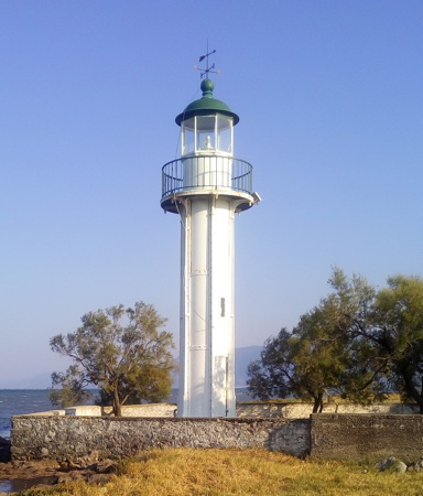
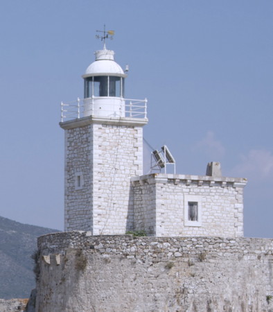
Arkitsa Light, Phthiotis, June 2019
Google Maps photo by Xristos Xa


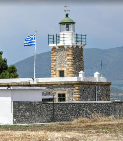
Avlida Light, Euboea, October 2020
Google Maps photo by n.p. production

East Macedonia and Thrace Region Lighthouses

East Macedonia and Central Macedonia were ceded to Greece following the Balkan Wars of 1912-13. Western Thrace was assigned then to Bulgaria, but Bulgaria ceded the territory to Greece in the Treaty of Lausanne in 1923. In 1987 East Macedonia and Western Thrace were combined in forming the Eastern Macedonia and Thrace Region.

Western Thrace: Evros District Lighthouse
* Alexandroúpoli (Alexandroupolis, Dedeagatch)
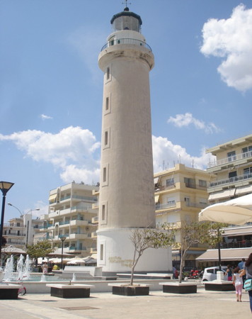
1880 (Ottoman). Active; focal plane 31 m (102 ft); three white flashes every 15 s. 27 m (89 ft) round masonry tower with lantern and gallery. Entire lighthouse painted white, except the lantern dome is green. A photo by Dimitris Siskopoulos is at right, Trabas has a closeup photo, Christina Bakaloglou has a 2017 closeup, Kyriakos Karapetros has a good 2018 photo, the Navy has a closeup of the light in action, and Google has a street view and a satellite view. Alexandroúpoli is the easternmost city of the Greek mainland, located about 15 km (9 mi) from the Turkish border. The city is relatively new; it was developed by the Ottoman Empire in the late 19th century and originally known as Dedeagatch. Greek forces took control in 1920 and renamed the city after Alexander I, who was then king of Greece. This handsome lighthouse is located right on the city's waterfront boulevard at the base of the main quay, making it one of the most accessible of all Greek lighthouses. Site open, tower closed. . ARLHS GRE-005; Admiralty N4554; NGA 16836.

Western Thrace: Rhodope District Lighthouse
* Ákra Fanári
Date unknown. Active; focal plane 40 m (131 ft); white light, 1.5 s on. 6.5 s off. 5 m (17 ft) skeletal tower mounted atop a large round water tank. Tank painted white. Trabas has a photo and Google has a satellite view. The Greek word fanári means a signal light, such as a traffic light. Located on a forested headland at Fanári, a village on the east side of the entrance to the bay of Vistonias. Site open, tower closed. Admiralty N4550; NGA 16796.

East Macedonia: Kavala District Lighthouses
Greek Macedonia, located at the northwestern end of the Aegean Sea, should not be confused with the landlocked former Yugoslav republic of Macedonia, now the independent nation known as North Macedonia. East Macedonia and the adjoining region of Central Macedonia became part of Greece in 1913.

*
Ákra Kará Ormán (Kavála, Kabála)
Date unknown. Active; focal plane 33 m (108 ft); white flash every 5 s. 4 m (13 ft) round lantern, painted white, mounted on a concrete pad. Trabas has a closeup photo, another photo is available, Kwstas Salonikios has a street view, and the lantern is visible in a Google satellite view. Kavála, located on the mainland opposite the island of Thasos, is the principal port of eastern Macedonia. Located at the tip of a blunt peninsula that shelters the east side of the harbor of Kavála. Site open, tower closed. Admiralty N4540; NGA 16736.
Alexandroupolis Light
Alexandroúpoli Light, Alexandroúpoli, May 2013
Flickr Creative Commons photo by Dimitris Siskopoulos
* Kavála (Kabála) North Breakwater
Date unknown. Active; focal plane 11 m (36 ft); red flash every 2 s. 11 m (36 ft) post light on a hexagonal base, standing atop a 1-story stone pierhead building. Lighthouse painted white with one narrow red band around the hexagonal section. Trabas has a photo , Andrey Bar has a 2019 street view, and Google has a satellite view. Located at the end of the north (really west) breakwater of Kávala. Accessible by walking the pier. Site open, tower closed. Admiralty N4542; NGA 16744.

Central Macedonia Region Lighthouses

Chalkidikí District Lighthouses
* Kassándra (Posidi)
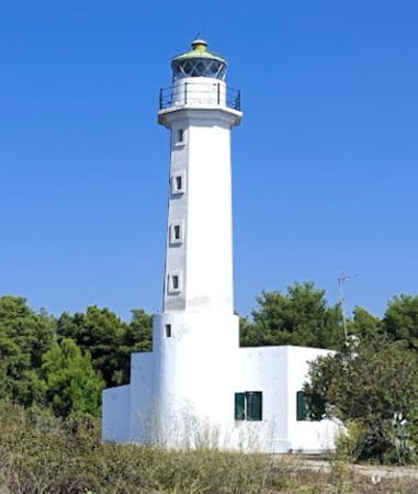
1864 (Ottoman). Active; focal plane 19 m (62 ft); two white flashes every 15 s. 14.5 m (47 ft) octagonal masonry tower with lantern and gallery, attached to a 1-story masonry keeper's house. Entire lighthouse painted white, except the lantern dome is green. A photo by Aleksei Shekhin is at right, Trabas has a closeup photo, Mihai Voicu has a good 2018 photo, Aleksandar Lazović has a 2017 closeup, the Navy has a photo, and Google has a street view of the tower and a satellite view of the station. There are three long, fingerlike peninsulas pointing into the Aegean in the Chalkidikí district of Central Macedonia. This lighthouse is on the south side of the Kassándra peninsula, the westernmost of the three. Located about about 2 km (1.2 mi) southwest of Posidi. Site open, tower closed. ARLHS GRE-138; Admiralty N4488; NGA 16640.

Thessaloníki District Lighthouses
Thessaloniki, known historically as Salonica, is the capital of Central Macedonia and second-largest city of Greece, with an urban population of more than 800,000. One of the largest seaports in the Eastern Mediterranean, it handles cargo to and from all of the Balkan countries to the north.

*
Megálo Émvolon (Megalou Emvolou, Karabournaki)
Date unknown (station established 1864). Active; focal plane 30 m (98 ft); flash every 10 s, white or red depending on direction. 10.5 m (35 ft) round cylindrical masonry tower with lantern and gallery, rising from one corner of a square 1-story masonry keeper's house. Fresnel lens in use. Entire lighthouse painted white, except the lantern dome is green. Fog horn (one blast every 60 s). Trabas has a good photo, a 2018 closeup is available, Nikos Giannopoulos has a 2016 photo, the Navy has a photo, Marita Kaloglou has a street view, and Google has a satellite view. This lighthouse stands on Ákra Megálo Émvolon and marks the east side of the entrance to the bay of Thessaloníki at the extreme northwestern corner of the Aegean Sea. According to Savas the area was part of a Hellenic Navy base and was closed to civilians, but it appears that this is no longer the case. Located on the cape about 5 km (3 mi) northwest of Nea Mihaniona and about 15 km (9 mi) southwest across the bay from Thessaloníki. Site open, tower closed. ARLHS GRE-096; Admiralty N4498; NGA 16576.
* Órmos Thessaloníkis
Date unknown. Active; focal plane 9 m (30 ft); three white flashes every 20 s (?). 8 m (26 ft) mast atop a square 2-story building. Trabas has a photo and Google has a street view and a satellite view. Although NGA describes only the white light, red and green lights are also seen on the tower. This is a leading light for the approach to Thessaloníki. Located on the yacht club pier on the east side of Thessaloníki harbor. Site open, tower closed. Admiralty N4503; NGA 16608.

Kassandra Light, Posidi, September 2021
Google Maps photo by Aleksei Shekhin
* Thessaloníki Harbor Office
Date unknown. Active; focal plane 18 m (59 ft); green light, 1.5 s on, 2.5 s off. Approx. 14 m (46 ft) square 3-story masonry tower at one corner of a 2-story masonry office building; the light is displayed from a short skeletal tower on the roof. Trabas has a good photo and Google has a street view and a satellite view. The light guides vessels entering the inner harbor of Thessaloníki, which is protected by a detached breakwater. Located at the end of Pier 1, the easternmost pier of the commericial harbor area. Accessible by walking or driving the pier. Site open, tower closed. Admiralty N4504; NGA 16628.
Axios (Kávoura)
1960. Active; focal plane 9 m (36 ft); two flashes every 12 s, white, red or green depending on direction. 8 m (26 ft) skeletal mast mounted at one end of a 1-story rectangular building. Fog horn (one long and one short blast every 60 s). Trabas has a closeup photo, Christopher Barbas has a photo, Mariano Ntrougkas has a 2020 photo, and Google has a satellite view. This is a leading light for entrance to the bay of Thessaloníki. The lighthouse stands on an island off the delta of the Axios River and marks the west side of the entrance to the bay at the extreme northwestern corner of the Aegean Sea. The attached building may have been a keeper's house but it is currently described as a church. Accessible only by boat. Site and tower closed. ARLHS GRE-047; Admiralty N4497; NGA 16584.

Pieria District Lighthouse
Ákra Atherídha
Date unknown. Active; focal plane 12 m (39 ft); white flash every 5 s. 9 m (30 ft) square iron skeletal tower rising from a 1-story iron equipment shelter. Trabas has a closeup photo, Sávvas Seïtarídis has a 2017 photo, and Google has a satellite view. This light marks the southern entrance to the Thermaic Gulf (Gulf of Salonika) leading to Thessaloníki. Located on a prominent cape about 10 km (6 mi) southeast of Methoni. Site status unknown. Admiralty N4496; NGA 16572.

Thessaly Region Lighthouses

The historic region of Thessaly was transferred from the Ottoman Empire to Greece in 1881 as part of the complex territorial adjustments arranged by the European powers following Ottoman losses in the Russo-Turkish war of 1877-78.

Magnesia District: Northern Sporades Lighthouses
Magnesia, a district in southeastern Thessaly, includes the major port of Volos and the chain of Aegean islands known as the Northern Sporades. The region surrounds the Pagasetic Gulf, a circular inlet of the Aegean Sea.
Psathoúra
1895. Active; focal plane 40 m (131 ft); white flash every 10 s. 25 m (82 ft) round stone tower with lantern and gallery, attached to a 1-story stone keeper's house. The lighthouse is unpainted, lantern painted white with a green dome. Niki Liakou has a 2017 photo, the Navy has a closeup photo, Vasilis Laringakis has a good view from the sea, and Bing has a distant satellite view. Psathoúra is a small, uninhabited island at the northeastern end of the Voriai (Northern) Sporades. The light guides ships bound for Thessaloníki around this island chain. Located at the highest point of the island. Accessible only by boat. Site open, tower closed. ARLHS GRE-029; Admiralty N4482; NGA 16464.
Ákra Téleio
Date unknown. Active; focal plane 21 m (69 ft); three white flashes every 12 s. 4 m (13 ft) round lantern, white with a red roof. Trabas has a photo, Gherardo Sanita' has a street view, and Google has a satellite view. Located at the southwestern tip of Alónnisos, one of the Northern Sporades islands, marking the narrow channel between that island and Skópelos. Site open, tower closed. Admiralty N4478; NGA 16472.
* Ákra Gouroúni (Guruni, Skópelos)
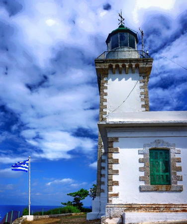
1884. Active; focal plane 70 m (230 ft); three white flashes every 30 s. 14 m (46 ft) square stone tower with lantern and gallery, rising from a 1-story stone keeper's house. Lighthouse painted white with unpainted stone trim; lantern dome painted green. A photo is at right, a fine 2007 closeup is available, Barnabas Redly has a closeup photo, Trabas has a fine photo, Claußen also has good photos by Olaf Riesenberg, Thomas Pößnecker has a street view from the base of the lighthouse, and Google has a satellite view. This lighthouse is on the island of Skópelos, largest of the chain of islands off the coast of Thessaly known as the Voriai (Northern) Sporades. This light and the next one frame a deep water passage used by coastwise shipping between the islands of Skíathos and Skópelos. The lighthouse appears to be in excellent condition. Skópelos is about 20 km (13 mi) long and has a population of about 5000. Located at the northwestern tip of the island, about 4 km (2.5 mi) northwest of Glossa. Accessible by an unpaved road. Site open, tower closed. . ARLHS GRE-071; Admiralty N4474; NGA 16480.
Répi (Repion)
1914. Active; focal plane 42 m (138 ft); two flashes every 10 s, white or red depending on direction. 15 m round masonry tower with lantern and gallery, attached to a 1-story masonry keeper's house. Lighthouse painted white; lantern dome painted green. Claußen has good photos, Trabas has a closeup photo, and Google has a satellite view. Located on Répi, a small island off the east coast of Skíathos and about 4 km (2.5 mi) east southeast of Skíathos village. Accessible only by boat. Site status unknown. ARLHS GRE-137; Admiralty N4472; NGA 16496.

Ákra Gouroúni Light, Skópelos, October 2020
Instagram photo by Aegean Blues - About GREECE

Magnesia District: Mainland Lighthouses
Ákra Sépia (Sipiás)
Date unknown. Active; focal plane 105 m (344 ft); white light, 2 s on, 8 s off. 4 m (13 ft) round cast iron lantern, painted white, mounted on a concrete pad. Trabas has a closeup photo and Google has a distant satellite view. Located on a prominent cape about 8 km (5 mi) northeast of Platania, marking the entrance to the strait between the mainland and the island of Skiathos. Site status unknown. Admiralty N4464; NGA 16520.
* Trikeri (Ákra Kavoúlia)
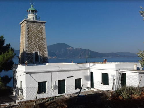
1864 (Ottoman). Active; focal plane 22 m (72 ft); three long (2 s) white flashes every 20 s. 14 m (46 ft) square rubblestone tower with lantern and gallery, attached to a 1-story masonry keeper's house. The lighthouse is unpainted stone; lantern painted white with a green dome; keeper's house painted white. Sofia Siatravani's photo is at right, she has a second photo, Trabas has a photo, the Navy has a photo, and Google has a satellite view. The lighthouse was built by French engineers for the Ottoman Empire; it became Greek when Thessalia (Thessaly) was ceded to Greece in 1881. It stands at the end of a long, hook-shaped peninsula that encloses the Pagasetic Gulf. Located on Ákra Kavoúlia, about 3 km (2 mi) west of Trikeri. Site open, tower closed. ARLHS GRE-128; Admiralty N4442; NGA 16528.
Argironisos
1899. Active; focal plane 32 m (105 ft); white flash every 5 s. 7 m (23 ft) round cylindrical tower with lantern and gallery, attached to a square 1-story keeper's house. Lighthouse painted white; lantern dome painted dark green. Claußen has good photos by Olaf Riesenberg, the Navy has a photo, Giorgos Russos has a view from the sea, Trabas has Meyer's distant view, and Google has a satellite view. This lighthouse marks the eastern entrance to the Oreon strait, which separates the northwestern end of Euboea from the mainland. Located on an island about 3 km (2 mi) east of Agios Dimitrios on the mainland, and about 5 km (3 mi) northwest of Kanatadika on Euboea. Accessible only by boat. Site status unknown. ARLHS GRE-041; Admiralty N4440; NGA 16420.

Trikeri Light, Trikeri, October 2017
Google Maps photo by Sofia Siatravani

Lighthouses of Central Greece

Phthiotis District Lighthouses
Phthiotis is the mainland region of Central Greece facing Euboea from the west, across the Gulf of Euboea.

*
Anteros (Cape Chiliomili, Ákra Khiliomíli)
1890. Active; focal plane 10 m (33 ft); three white flashes every 15 s. 8 m (26 ft) round cylindrical cast iron tower with lantern and gallery, painted white; lantern dome painted dark green or black. Kleánthis Mavrópoulos has the 2016 closeup at right showing the lighthouse freshly painted, Trabas has Meyer's closeup photo, Kostantinos Champipis has a 2015 closeup, and Bing has a satellite view. This little lighthouse is a typical French tourelle, a type of prefabricated lighthouse installed in countries all over the world in the years just before and after 1900. Located on a sharp cape at the south side of the entrance to the Maliakos Kolpós, about 5 km (3 mi) north of Skarfia. Site open, tower closed. ARLHS GRE-057; Admiralty N4424; NGA 16388.
* Arkítsa
1908. Active; focal plane 15 m (49 ft); two white flashes every 5 s. 15 m (49 ft) square cylindrical stone tower with lantern and gallery, rising from the seaward side of a square 1-story masonry keeper's house. The lighthouse is unpainted stone with white trim; lantern dome painted dark green. A photo by Xristos Xa is at the top of this page, Trabas has a photo, Christos Lappas has a good photo, Nikos Zafash has a 2022 photo, the Navy has a photo, a portfolio of photos is available, and Google has a street view and a satellite view. Located on Ákra Arkítsa, a sharp cape projecting into the Evvoikós Kolpós (Gulf of Euboea) at the town of Arkítsa. Site open, tower closed. . ARLHS GRE-042; Admiralty N4416; NGA 16360.
[Atalánti]
Date unknown. Active; focal plane 10 m (33 ft); white flash every 1.5 s. 5 m (17 ft) short post atop a skeletal tower, painted white. Behind the light is a ruined stone keeper's cottage. Trabas has Meyer's photo and Google has a satellite view. Located on an islet off the northern tip of Atalánti, an island in the Gulf of Euboea about 3 km (2 mi) southeast of Livanates. Accessible only by boat. Site open, tower closed. Admiralty N4412; NGA 16352.

Anteros Light, Skarfia, September 2016
ex-Google Plus photo by Kleánthis Mavrópoulos

Euboea District Lighthouses
Euboea is a mountainous island, about 180 km (110 mi) long but nowhere more than 50 km (30 mi) wide, close to the Greek mainland north of Attica. The southeast end of the island is separated from Attica by the Gulf of Petalion, and the northeast end is separated from the mainland of Boeotia and Phthiotis by the narrow Gulf of Euboea. In the center, at Chalcis, the separation between Euboea and the Boeotian mainland is the very narrow Eúripus Strait believed to have been opened several thousand years ago by an earthquake. Two bridges cross the strait at Chalcis, linking Euboea to the mainland.
* Kakokefalí (Halkida, Chalkida, Chalkis)
1886. Active (?); focal plane 21 m (69 ft); two red flashes every 18 s. 12 m (39 ft) square cylindrical masonry tower with lantern and gallery. Trabas has Meyer's photo, Claußen has a photo by Olaf Riesenberg, Vasilis Poul has a nice photo, a 2018 closeup is available, Petros Politis has a 2022 closeup, the Navy also has a closeup, and Google has a satellite view. Although NGA continues to describe the lighthouse in its listing, it appears that the active light has been moved to the skeletal tower in front of the building. The name Kakokefalí means "bad cape," a reference to the dangerously strong tidal currents through the narrow Eúripus Strait. Located in Halkida, marking the northern entrance to the narrow strait separating Euboea from the mainland. Site status unknown but probably open, tower closed. ARLHS GRE-075; Admiralty N4378; NGA 16328.
Strongíli
1870. Active; focal plane 41 m (135 ft); two flashes every 10 s, white or red depending on direction. 9 m (30 ft) round tower with lantern and gallery, attached to a 1-story keeper's house. Lighthouse painted white; lantern dome is dark green or black. Claußen has photos by Olaf Riesenberg, Trabas has Meyer's photo, Alexander Chalkidis has a 2020 photo, and Google has a satellite view. Located on a small island in the Gulf of Euboea off the western tip of the island of Euboea. Accessible only by boat. Site status unknown. ARLHS GRE-124; Admiralty N4420; NGA 16380.
* Vasilína
1892. Active; focal plane 9 m (30 ft); white or green light, depending on direction, occulting once every 5 s. 10 m (33 ft) square cylindrical stone tower with lantern and gallery, attached to the seaward side of a square 1-story masonry keeper's house. The lighthouse is unpainted stone with white trim; lantern painted white with a dark green dome. Tibor Zágonyi has a 2018 photo (also seen at right), Trabas has a photo, Claußen has a photo by Olaf Riesenberg, Pavlos Vlazakis has a 2022 photo, the Navy has a closeup photo, Marita Kaloglou has a photo and a street view, and Google has a satellite view. This lighthouse marks the western entrance to the Oreon strait, which separates the northwestern end of Euboea from the mainland. Located on Akra Vasilina, a point of land projecting into the strait, about 5 km (3 mi) north of Ágios Geórgios. Site open, tower closed. . ARLHS GRE-129; Admiralty N4432; NGA 16408.
Pontikonísi (Ákra Artemision)
1907. Active; focal plane 62 m (203 ft); two flashes every 15 s, white or red depending on direction. 19 m (62 ft) round masonry tower with lantern and gallery, attached to the seaward side of a square 1-story stone keeper's house. The lighthouse is unpainted; lantern painted white with a dark green dome. Mariana Angelidou has a 2023 photo, Tom Karanakis has a photo, Matína Stathakopoúlou has a view from the sea, Trabas has a photo, and Google has a satellite view. The light guides ships around Ákra Artemision, the northernmost point of Euboea, into the strait of Skiathou. Located on a small island about 2.5 km (1.5 mi) northeast of Ákra Artemision. Accessible only by boat. Site status unknown. ARLHS GRE-110; Admiralty N4458; NGA 16516.

Vasilína Light, Ágios Geórgios, June 2018
Google Maps photo by Tibor Zágonyi
Prasoúda (Prasuda)
1897. Active; focal plane 42 m (138 ft); white flash every 5 s. 18 m (56 ft) round stone tower with lantern and gallery, attached to a 1-story stone keeper's house. The lighthouse is unpainted stone; lantern painted white with a dark green dome. Vangelis Moutafis has a 2019 photo, the Navy has a closeup photo, Trabas has Meyer's photo, and Google has a satellite view of the station. The light guides ships around a prominent cape on the northeastern coast of Euboea. Located on a small island about 12 km (7.5 mi) northeast of Kimi. Accessible only by boat. Site status unknown. ARLHS GRE-112; Admiralty N4453; NGA 16432.
Lithári (Skíros, Skyros)
1894. Active; focal plane 96 m (315 ft); three white flashes every 30 s. 12 m (39 ft) round stone tower with lantern and gallery, attached to a 1-story stone keeper's house. The lighthouse is unpainted, lantern painted white with a green dome. Trabas has a photo by Capt. Peter Mosselberger, a 2020 photo is available, Dimitris Tzannis has a view from above, and Google has a satellite view. Skíros (Skyros), the southernmost of the Sporades, is located about 40 km (25 mi) northeast of Kimi, Euboea. The island is about 25 km (15 mi) long and has a population of about 3000. The lighthouse is located on Ákra Lithári, the southeastern tip of the island. Land access is difficult; the lighthouse is at least 5 km (3 mi) from the nearest road, over very rough terrain. Site status unknown. ARLHS GRE-092; Admiralty N4454; NGA 16444.
Mandili (Mandiloú)
1925. Active; focal plane 83 m (272 ft); three white flashes every 20 s. 10 m (33 ft) round tower with lantern and gallery, attached to a 1-story keeper's house. Lighthouse painted white. Trabas has Capt. Peter Mosselberger's photo (also seen at right), Markus Wimmer has a 2016 photo, and Google has a satellite view. Located atop an island off the southeastern tip of Euboea, marking the entrance to the Kolpós Petalion, the gulf separating southern Euboea from the Attic peninsula. Accessible only by boat. Site status unknown. ARLHS GRE-094; Admiralty N4451; NGA 16228.
* Avlída (Stenó Avlídhas, Ákra Avlís)
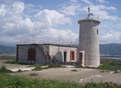
1880. Reactivated; focal plane 9 m (30 ft); two white flashes every 12 s. 9 m (30 ft) square cylindrical masonry tower with lantern and gallery, rising from the seaward side of a square 1-story masonry keeper's house. Lighthouse painted white; lantern dome painted dark green. A 2020 photo is at the top of this page, Trabas has Meyer's closeup photo, Dimitris Katsoulas has a 2019 photo, Claußen has a photo by Olaf Riesenberg, the Navy has a closeup photo, and Google has a street view and a satellite view. This lighthouse marks the southern entrance to the narrow strait separating Euboea from the mainland. (Avlída is on the mainland, but it is part of the Chalcis municipality on Euboea.) It appears that the light was moved to a skeletal mast for a time, but recent photos show the light returned to a restored lighthouse. Located on the waterfront in Avlída. Site open, tower closed. . ARLHS GRE-046; Admiralty N4366; NGA 16308.

Mandili Light, Euboea
photo copyright Capt. Peter Mosselberger; used by permission

Boeotia District Lighthouse
Boeotia and Phocis are districts of the Central Greece region that are located on the north side of the Gulf of Corinth and the south side of the Attica Peninsula. Lighthouses of Attica (including the Athens area) are described on the Southern Greece page.

*
Antíkyra (Antikira)
2003(?). Active; focal plane 10 m (33 ft); green flash every 4 s. 10 m (33 ft) round cylindrical concrete block tower with lantern and gallery. The tower is unpainted white concrete; lantern dome painted green. Stairs lead to an observation platform atop an equipment shelter attached to the tower. Trabas has Meyer's photo, another closeup photo is available, Dimitris Karras has a 2021 photo, Wikimedia has a photo, and Google has a street view and a satellite view. NGA misspells the name as "Andikira." Located at the end of the pier at Antíkyra. Accessible by walking the pier. Site and observation deck open, tower closed. Admiralty N3970.5; NGA 14833.

Phocis District Lighthouses
[Apsifiá (Galaxidí, Agios Georgios)]
Date unknown. Active; focal plane 13 m (43 ft); white flash every 7 s. 5 m (17 ft) skeletal tower atop a short post, painted white. Behind the light is a ruined stone keeper's cottage. Trabas has a distant photo, a drone view is available, and Google has a satellite view. Located on Apsifiá island, about 1.5 km (1 mi) east of Galaxidi. Accessible only by boat. Site open, tower closed. Admiralty N3960; NGA 14816.
Psaromyta
1894. Active; focal plane 65 m (213 ft); two white flashes every 15 s. 9 m (30 ft) round rubblestone tower with lantern and gallery, attached to the seaward side of a 1-story rubblestone keeper's house. The lighthouse is unpainted; lantern painted white, lantern roof dark green. Eleni Tsitoura's 2023 photo is at right, Trabas has Meyer's photo, Agelva Vangelis has a 2021 photo, Níkos Karastáthis has a closeup, the Navy also has a closeup, Maria Panagiotopoulou has a 2018 photo, and Google has a satellite view. Located on a prominent cape on the north side of the Gulf of Corinth, about 4 km (2.5 mi) southeast of Agios Nikolaos. According to Savas the light is at the end of dirt road that intersects the main coastal highway 1.5 km (1 mi) southeast of Agios Nikolaos. This entrance is unmarked but not gated. 4WD recommended. Site apparently open, tower closed. ARLHS GRE-114; Admiralty N3956; NGA 14804.

Psaromyta Light, Ágios Nikólaos, July 2023
Google Maps photo by Eleni Tsitoura

Northern West Greece Region Lighthouses

Aetolia-Acarnania (Aitoloakarnanía) Lighthouses
Aetolia-Acarnania is the district of the West Greece region that lies north of the Gulfs of Patras and Corinth. The northern border of the district is on the south shore of the Ambracian Gulf (Gulf of Amvrakikos), while the southern border is mostly on the Gulf of Patras. The Gulf of Patras is connected to the Gulf of Corinth by a narrow strait at Antirrío in the southeastern corner of the prefecture. Lighthouses of the West Greece region south of the Gulf of Patras are described on the Southern Greece page.
* Nafpaktos (Naupactus)
1909. Active; focal plane 13 m (43 ft); green flash every 2 s. 6 m (20 ft) square cylindrical unpainted stone tower with a pyramidal top; the light is mounted at the peak. The light tower is built atop the wall of a fortification that protected the harbor. A closeup photo is available, Trabas has Meyer's photo, there is an aerial photo of the harbor, Ilías Spanós has a street view across the harbor entrance, and Google has a satellite view. Located on the east side of the harbor entrance at Nafpaktos, about 10 km (6 mi) northeast of Antiríon. Site open, tower closed. ARLHS GRE-134; Admiralty N3942; NGA 14792.
* Antirrío (Antiríon)
1880. Active; focal plane 16 m (52 ft); two white flashes every 10 s. 9 m (30 ft) round stone tower with lantern and gallery, built atop the wall of a ruined Ottoman castle. The lighthouse is unpainted; lantern painted white; lantern roof is gray metallic. Valeriy Pikulskyy has a photo; her photo was probably taken from the spectacular Ríon-Antírrion Bridge, which was completed in 2004. A photo is at right, Trabas has Meyer's photo, Thomas Knoblauch has a closeup, the Navy has a photo of the light in action, Giorgos Roussos has a view from the sea, Marita Kaloglou has a street view, and Google has a satellite view. Cape Antirrion is a sharp promontory forming the north side of the Ríon Strait, the 1.9 km (1.2 mi) wide entrance to the Gulf of Corinth. Sultan Bayazet II built castles on both sides of the strait in 1500, as the Ottoman Empire was in the process of conquering western Greece from Venice. Site open, tower closed; parking is available at the ferry terminal just outside the castle walls. ARLHS GRE-006; Admiralty N3938; NGA 14784.
Ágios Sóstis
1859. Active; focal plane 12 m (39 ft); flash every 5 s, white or red depending on direction. 11 m (36 ft) stone tower with lantern and gallery, attached to the seaward side of a 1-story keeper's house. The tower is unpainted white stone; lantern and keeper's house painted white; lantern roof is green. Panagiotis Theodoridis has a closeup 2022 photo, aerial photo is available, Trabas has a photo, and Google has a satellite view. The island of Ágios (Saint) Sostís lies on the north side of the Gulf of Patraikós in the entrance to the bay of Mesolóngi about 8 km (5 mi) southwest of the city of Mesolóngi. The only other structures on the small island are a ruined customshouse and the chapel of St. Sostis. Accessible only by boat. Site open, tower closed. ARLHS GRE-055; Admiralty N3912; NGA 14756.
Vrachonisída Kalógiros (Nisis Kaloyeros)
Date unknown. Active; focal plane 31 m (102 ft); white flash every 4 s. 4 m (13 ft) round white lantern. Trabas has a photo and Google has a satellite view. The light guides ships bound for the town of Astakos. Located on the northern end of Kalógiros, an island in the entrance of the bay of Astakou. Accessible only by boat. Site status unknown. Admiralty N3896; NGA 14616.
Antirrio Light
Antírrio Light, Antirrío, May 2010
ex-Panoramio photo copyright M CM LXX IV; permission requested
[Voliós]
1913. Active; focal plane 8 m (26 ft); one quick flash every 1.5 s, white or red depending on direction. 4.5 m (15 ft) square stone post light standing in front of a ruined 1-story stone keeper's cottage. Trabas has a photo, a 2020 photo and a view from the sea are available, and Google has a satellite view. This light marks the southern entrance to the strait separating Lefkada from the mainland; it is located on a small island just off the mainland about 6 km (3.5 mi) south of the Lefkada bridge. (It is not on Lefkada, as both Savas and ARLHS imply.) Site status unknown. ARLHS GRE-130; Admiralty N3842; NGA 14584.
* Lefkáda (Lefkas, Santa Maura)
1861 (British). Active; focal plane 17 m (56 ft); two flashes every 12 s, white or red depending on direction. 6 m (20 ft) square cylindrical stone tower with lantern and gallery, attached to a small 1-story keeper's cottage. The lighthouse is unpainted; lantern painted white. The lighthouse is built on one corner of the 14th century Byzantine fortress of Santa Maura (Agia Mavra), which is otherwise in ruins. Patrizia Ferri's photo is at right, Trabas has an excellent photo, George Zaf has a 2021 photo, Claußen has photos by Olaf Riesenberg, Wikimedia has a photo, and Google has an excellent street view and a satellite view. The northern end of the island of Lefkáda, one of the Ionian Islands, is separated from the mainland only by a narrow channel, now crossed by a causeway and floating bridge. The citadel protects the northern entrance to this channel and is located on the east (mainland) side, just north of the bridge, in the city of Palairos. Site open, tower closed. ARLHS GRE-184; Admiralty N3832; NGA 14560.
* Áktio (Akteon) Range Front
1928. Active; focal plane 5 m (16 ft); quick-flashing yellow light. 4 m (13 ft) 1-story keepers house; the light is displayed from a small platform over the front door. There is a triangular red daymark mounted above the light. House painted white with a red tile roof. Trabas has Meyer's closeup photo, Spiros Baracos has a similar photo, and Google has a street view and a satellite view. The range guides ships through the narrow entrance to the Ambracian Gulf. The rear light is on a small skeletal tower. Located on the beach on the south side of the entrance, in Áktio. Accessible by road, but the turnoff to the lighthouse is unmarked. Site open, tower closed. Admiralty N3804; NGA 14504.
Ákra Panagía
Date unknown. Active; focal plane 6.5 m (19 ft); green light, 2.5 s on, 5 s off. 4.5 m (15 ft) round lantern painted white with a narrow green horizontal band. Trabas has a distant view and Google has a satellite view. Located at the tip of a long peninsula projecting into the south side of the Ambracian Gulf. May be accessible only by boat. Site status unknown. Admiralty N3812; NGA 14556.
Faros Lefkada
Lefkáda Light, Palairos, August 2009
Flickr Creative Commons photo by Patrizia Ferri

Epirus Region Lighthouses

Epirus occupies the northwestern corner of the Greek mainland, adjoining Albania. The region is mountainous and has no major ports. The southern border of the region is on a large, nearly land-locked bay, the Ambracian Gulf (Gulf of Amvrakikos), which is connected to the Ionian Sea by a narrow channel, the Strait of Preveza. Like Thessaly, most of Epirus was transferred from the Ottoman Empire to Greece in 1881 as part of the complex territorial adjustments arranged by the European powers following Ottoman losses in the Russo-Turkish war of 1877-78.

Arta District Lighthouse
** Koprenas (Ákra Kópraina)
1893. Active; focal plane 9 m (30 ft); two flashes every 16 s, white or red depending on direction. 9 m (30 ft) round stone tower with gallery; lantern removed. The lighthouse is unpainted white stone with trim painted red. The small 1-story keeper's cottage, standing next to the lighthouse, was restored as a museum in 2000. A photo by G. Karpathakis is at right, Vangelis Kousoulas has a fine 2018 photo, the Navy has a good closeup, Trabas has a good closeup photo, and Bing has a satellite view. This site is very popular with birders. Located at the end of a long, sandy spit projecting into the northeastern corner of the Gulf of Amvrakikos about 1.5 km (1 mi) south of Aliki. Site open, museum schedule unknown, tower probably open when the museum is open. ARLHS GRE-085; Admiralty N3820; NGA 14536.

Thesprotía District Lighthouse
Murtos (Mavro Oros, Syvota, Sívota)
1884 (Ottoman). Active; focal plane 87 m (285 ft); three white flashes every 20 s. 14 m (46 ft) octagonal stone tower with lantern and gallery, attached to the ruins of a keeper's house. The lighthouse is unpainted; lantern painted white. A 2018 closeup photo is available, Vangelis Doutsios has a photo, Larry Myhre has a distant view, and Google has a satellite view and a street view from the gallery. This lighthouse was built by French contractors for the Ottoman Empire; the area was ceded to Greece in 1913 at the end of the Balkan Wars. The lighthouse marks the southern enrance to the Kérkyra (Corfu) Strait seprating that island from the mainland. Located on a very steep promontory at the western end of the island of Sívota, about 3 km (2 mi) west of the mainland town of the same name. Accessible only by boat; there does not appear to be any land access. Site status unknown. ARLHS GRE-118; Admiralty N3786; NGA 14476.
Koprenas Light
Koprenas Light, Arta
ex-Panoramio photo copyright G. Karpathakis; used by permission

Information available on lost lighthouses:

Notable faux lighthouses:

Adjoining pages: North: North Macedonia | Northeast: European Turkey | East: Aegean Islands | South: Southern Greece | West: Ionian Islands | Northwest: Albania

Return to the Lighthouse Directory index | Ratings key

Posted November 27, 2006. Checked and revised October 23, 2023. Lighthouses: 38. Site copyright 2023 Russ Rowlett and the University of North Carolina at Chapel Hill.