Lighthouses of Indonesia: Western Sulawesi (Celebes)

The Republic of Indonesia has been independent since 1945 after having been the Dutch East Indies for more than 350 years. It is a huge country, stretching along both sides of the Equator for more than 46 degrees of longitude (roughly 5100 km or 3200 miles). Comprised of some 17,000 islands (more than 6000 inhabited islands), it has hundreds of major aids to navigation.

Sulawesi (Celebes) is a major island in the northern part of the country. Shaped like an artistically drawn letter K, Sulawesi consists mostly of four narrow peninsulas. The Makassar Strait separates Sulawesi from Kalimantan (Borneo) to the west. The Celebes Sea is north of the island, the Molucca Sea is on the northeast, the Banda Sea is to the southeast, and the Flores Sea is on the south. Makassar, also called Ujung Pandang, is the major port.

Indonesia is divided into 38 provinces (provinsi) and the provinces are subdivided into county units called regencies (kabupaten). This page covers the west side of Sulawesi including the province of West Sulawesi and the west coast of Central Sulawesi Province.

On 28 September 2018 a magnitude 7.5 earthquake caused severe damage to the southern half of the Minahasa Peninsula and swamped the port of Palu by a tsunami. Information was scarce on damage to the lighthouses of this area.

More than 700 languages are spoken in Indonesia. The official national language, Indonesian (Bahasa Indonesia), was standardized from a form of Malay that served as a lingua franca across the archipelago. In Indonesian a lighthouse is a mercusuar or a menara suar. Tanjung is a cape, ujung is a headland or point of land, bukit is a hill, sungai is a river, kuala or muara is an estuary or river mouth, pulau is an island, karang is a reef, batu is a rock, laut is a sea, selat is a strait, teluk is a bay, pelabuhan is a harbor, and labuhan is a port.

Aids to navigation in Indonesia are operated and maintained by the Directorate of Marine Navigation within the Directorate General of Sea Transportation.

ARLHS numbers are from the ARLHS World List of Lights. DSI numbers, whwre available, are the Indonesian light list numbers. Admiralty numbers are from volumes F and Q of the Admiralty List of Lights & Fog Signals. U.S. NGA List numbers are from Publication 112.

General Sources
Online List of Lights - Indonesia - Sulawesi - Vol. F and Vol. Q
Photos by various photographers posted by Alexander Trabas. Volume F includes lights north of the Equator and Volume Q includes lights south of the Equator.
Indonesian Lighthouses
Historic postcard views from the collection of Michel Forand.
World of Lighthouses - Indonesia
Photos by various photographers available from Lightphotos.net.
Navionics Charts
Navigation chart for Sulawesi.

Teluk Palu Light, Donggala, January 2017
ex-Radar Sulteng Online photo by Muhammed
Sulawesi Barat (West Sulawesi) Province Lighthouses

West Sulawesi Province was separated from South Sulawesi Province in 2004. West Sulawesi faces the Strait of Makassar and has a population of about 1.5 million. Because of shoals extending from the coast of Kalimantan (Borneo) the shipping channel in the Strait passes close to the coast of West Sulawesi.

Polewali Mandar Regency Lighthouses
Polewali Mandar Regency faces south on Mandar Bay (Teluk Mandar), a bight on the east shore of the Makassar Strait.

* Tanjung Silopo (Polewali)
Date unknown. Active; listed with focal plane 14 m (46 ft); white flash every 3 s. Approx. 14 m (46 ft) square white skeletal tower with gallery. Kyanza Channel has a 2019 photo, Iyan Arisandi also has a 2019 photo, the tower is the right edge of Syahril Nasdem's 2018 photo, and Google has a satellite view. The regency capital of Polewali is the second largest town of West Sulawesi Province with a population of about 60,000. The listed location of this light is 10 km (6 mi) northwest, offshore of downtown Polewali. The older port there appears to be abandoned in favor of the newer Tanjung Silopo port and the light has also moved, unknown to the Admiralty. Located on the quay of the Tanjung Silopo harbor in southeast Polewali. Site open, tower closed. Admiralty Q1500; NGA 25485.

Majene Regency Lighthouses
The regency capital of Majene is a historic seaport sheltered by Tanjung Rangasa (Cape Mandar) at the northern entrance to Mandar Bay.
* Majene (2)
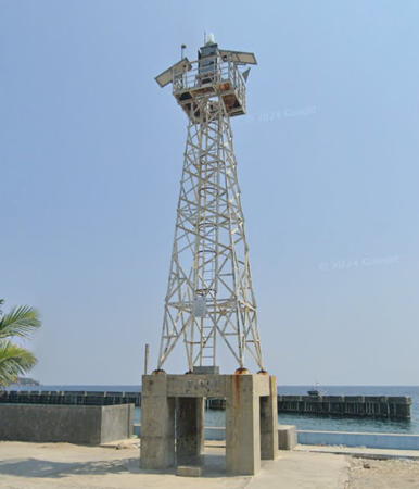
Date unknown. Active; focal plane about 25 m (82 ft); continuous white light. Approx. 22 m (72 ft) square white skeletal tower with gallery mounted on a concrete platform supported by piles. Fadly Muh has a photo, Hasbullah Asruddin has a closeup street view, and Google has a satellite view. NGA lists a tower only 6 m (20 ft) tall. Located on the quay at Majene, a town at the western end of Teluk Mandar. Site open, tower closed. Admiralty Q1498; NGA 25488.
Majene South
Date unknown. Active; focal plane 15 m (49 ft); red flash every 4 s. 15 m (49 ft) skeletal tower on a platform supported by piles. Google has a street view and a satellite view. Located at the edge of a large shoal area about 2 km (1.25 km) southwest of Majene. Accessible only by boat. Site open, tower closed. Admiralty Q1497.
* Pelabuhan Baru Majene
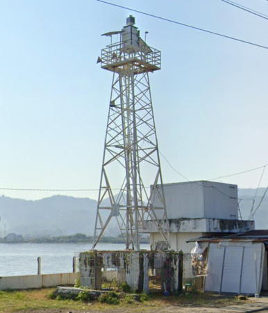
2017-18. Active; focal plane about 20 m (66 ft); white light, pattern unknown. Approx. 17 m (56 ft) square white skeletal tower with gallery mounted on a 1-story equipment shelter. Reski Syam has the 2018 photo seen at right and Google has a satellite view. "Pelabuhan Baru" mean "New Harbor." Located on a wharf about 2 km (1.25 mi) southwest of the original Majene harbor. Site open, tower closed. Admiralty Q1496.6.
Passanrangan North
Date unknown. Active; focal plane 14 m (46 ft); red flash every 3 s. 14 m (46 ft) barbell-shaped tower on a platform supported by piles. No photo available but Google has a satellite view. Located on the east edge of a large shoal area about 500 m (0.3 mi) south southeast of the Pelabuhan Baru Majene harbor. Accessible only by boat. Site open, tower closed. Admiralty Q1496.7.
Passanrangan South
Date unknown. Active; focal plane 14 m (46 ft); red flash every 4 s. 14 m (46 ft) barbell-shaped tower on a platform supported by piles. Google has a 2023 street view and a satellite view. Located off the east edge of a large shoal area about 500 m (0.3 mi) south southeast of the Passanrangan North Light. Accessible only by boat. Site open, tower closed. Admiralty Q1496.8.

Pelabuhan Baru Majene Light, Majene, June 2018
Google Maps photo by Reski Syam
Tanjung Rangasa (Cape Mandar)
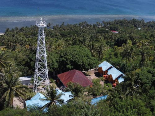
Date unknown. Active; focal plane 105 m (344 ft); white flash every 5 s. 25 m (82 ft) white iron skeletal tower. Several coast guard buildings. Muhammad Ridwan has a closeup 2021 drone view and the more distant drone view seen at right; Google has a satellite view. Located on a prominent cape in Banggae, a town about 5 km (3 mi) southwest of Majene (Madjene). Site status unknown. ARLHS IDO-325; DSI-5080; Admiralty Q1496; NGA 25492.
Tanjung Rangasa West
Date unknown. Active; focal plane 14 m (46 ft); white flash every 5 s. 14 m (46 ft) square white skeletal tower on a platform supported by piles. Google has a 2023 street view and a satellite view. Located on the edge of shoals about 1 km (0.6 mi) west of the point of Tanjung Rangasa. Accessible onky by boat. Site open, tower closed. DSI-5081; Admiralty Q1496.5.
Tanjung Binanga
Date unknown. Active; focal plane 24 m (79 ft); white flash every 6 s. Approx. 20 m (66 ft) square pyramidal skeletal tower, painted white. No photo available but Google has a satellite view. Located on a promontory at Palangpalang, about 40 km (25 mi) north of Majene (Madjene). Site probably open, tower closed. Admiralty Q1494; NGA 25494.
Tanjung Ongkone
Date unknown. Active; focal plane 14 m (46 ft); white flash every 4 s. 14 m (46 ft) square white skeletal tower. Google has a distant 2021 street view through trees and a satellite view. Located on a remote point of land about 40 km (25 mi) south of Mamuju. Site status unknown. Admiralty Q1493; NGA 25496.

Tanjung Rangasa (Cape Mandar) Light, Majene, July 2021
ex-Google Maps photo by Muhammad Ridwan

Mamuju Regency: Mainland Lighthouses
A city of about 120,000 residents, Mamuju is the capital of West Sulawesi Province.

Tanjung Kai (Tanjung Ngalo Mumuju)
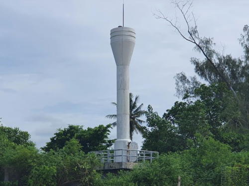
Date unknown. Active; focal plane 16 m (52 ft); white flash every 5 s. 10 m (33 ft) round barbell-shaped white fiberglass tower. Ikhwan Mahmud has the 2020 photo also seen at right, Rovi Glblues has a 2020 closeup and Google has a fuzzy satellite view. Located on a sharp cape about 20 km (13 mi) southwest of Mamuju. Site status unknown. Admiralty Q1491; NGA 25502.
* Tanjung Rangas (Sumare)
Date unknown. Active; focal plane 99 m (325 ft); white flash every 6 s. 21 m (69 ft) white iron skeletal tower. Several coast guard station buildings. Rovi Glblues has a 2020 closeup photo and Google has a satellite view and a very distant street view. Located on a prominent cape about 10 km (6 mi) northwest of Mamuju. Accessible by road and a short, very steep hike; the entrance is marked. Site status unknown. ARLHS IDO-324; Admiralty Q1490; NGA 25500.
Simboro Mamuju West
Date unknown. Active; focal plane 13 m (43 ft); green flash every 5 s. 13 m (43 ft) square skeletal tower painted green and mounted on a square platform supported by piles. Etty Atthur has a distant view, Asdar Munandar has the view from the ferry pier, and Google has a street view and an indistinct satellite view. Note: NGA has reversed the Admiralty numbers of the two Mumuju lights. Simboro is a town and ferry port on the western edge of Mamuju City. Located close offshore north of the Mumuju ferry harbor. Accessible only by boat. Site open, tower closed. Admiralty Q1490.15; NGA 25503.

TYanjung Kai Light, Mamuju, November 2020
Google Maps photo by Ikhwan Mahmud
* Simboro Mamuju
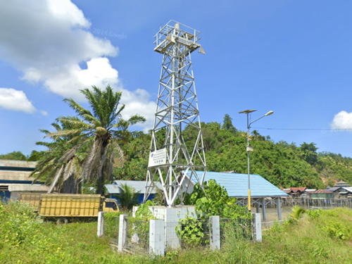
Date unknown. Active; focal plane 15 m (49 ft); white flash every 3 s. 13 m (43 ft) square skeletal tower painted white. Douglas McArthur Wihyawari has a 2024 view from the end of the pier, Google has a 2023 street view (also seen at right) and a satellite view. Located on the quay of the Mumuju ferry harbor. Site open, tower closed. Admiralty Q1490.1; NGA 25503.5.
Simboro Mamuju North
Date unknown. Active; focal plane 16 m (52 ft); red flash every 4 s . 16 m (52 ft) square skeletal tower painted red and mounted on a square platform supported by piles. Faisal Reza Sukmawan has a very distant view and Google has a satellite view. Located at the west end of a reef about 500 m (0.3 mi) northeast of Mumuju's eastern harbor. Accessible only by boat. Site open, tower closed. Admiralty Q1490.4.
* Pelabuhan Mamuju
Date unknown (recent). Active; focal plane about 15 m (49 ft); white flash every 5 s. Approx. 15 m (49 ft) square white skeletal tower mounted on a square platform supported by piles. A 2017 photo is available, Arman Husain has a 2020 photo, Novrizal Herdananto has an aerial view, and Google has a 2023 street view and a satellite view. Located at Mumuju's eastern harbor. Site open, tower closed. Admiralty Q1490.5.
Belang-Belang No. 1
Date unknown. Active; focal plane about 14 m (46 ft); green flash every 5 s. Approx. 14 m (46 ft) square skeletal tower painted green and mounted on a square platform supported by piles. Google has a street view from shore and an indistinct satellite view. NGA lists these three Belang-Belang lights with heights of 7 m (23 ft) but it is clear that they are taller. Located at the north end of shoal in the approach to the small port of Belang-Belang, about 40 km (25 mi) northeast of Mamuju. Accessible only by boat. Site open, tower closed. Admiralty Q1489.2; NGA 25503.6.
Belang-Belang No. 2
Date unknown. Active; focal plane about 14 m (46 ft); red flash every 4 s. Approx. 14 m (46 ft) square skeletal tower painted red and mounted on a square platform supported by piles. Google has a street view from shore and an indistinct satellite view. Located at the south end of shoal in the approach to the port of Belang-Belang. Accessible only by boat. Site open, tower closed. Admiralty Q1489.1; NGA 25503.65.

Simboro Mamuju Light, Mamuju, October 2023
Google Maps street view
Belang-Belang No. 3
Date unknown. Active; focal plane about 14 m (46 ft); red flash every 4 s. Approx. 14 m (46 ft) square skeletal tower painted red and mounted on a square platform supported by piles. Google has a street view from shore and a distant satellite view. Located at the south end of shoal in the approach to the small port of Belang-Belang. Accessible only by boat. Site open, tower closed. Admiralty Q1489; NGA 25503.7.
Pulau Liutang
Date unknown. Active; focal plane 90 m (295 ft); white flash every 5 s. 15 m (49 ft) slender white skeletal tower. Andang Rohman has a distant view (light at the highest point of the island) and Google has an indistinct satellite view. Located atop an island sheltering the port of Belang-Belang. Site status unknown. Admiralty Q1488.8.

Mamuju Regency: Balabalagan Islands Lighthouses
The Balabalagan Islands are reefs and islets in Makassar Strait emerging from a dangerous reef extending southeastward from Kalimantan (Borneo). Geographically and geologically the islands are associated much more with Kalimantan (Borneo) than with Sulawesi, but administratively they are governed as a district of Mamuju Regency.

Kepulauan Balabalagan (Pulau Balabalagan, Pulau Ambo)
Date unknown. Active; focal plane 40 m (131 ft); three white flashes every 20 s. 40 m (131 ft) skeletal tower, painted white. E.R. Ilenker has a distant drone view (a portion is seen at right) and Bing has a satellite view. Located on the southeasternmost of the islands in the middle of the Makassar Strait about 175 km (110 mi) southeast of Balikpapan. Accessible only by boat. Site status unknown. ARLHS IDO-177; Admiralty Q1488.5; NGA 24944.

Pulau Balabalagan Light, Makassar Strait, December 2017
Google Maps photo by E.R. Ilenker
Pulau Seturian
Date unknown. Active; focal plane 13 m (43 ft); quick-flashing white light. 13 m (43 ft) tower mounted on a square platform supported by piles. This light is described as a cardinal beacon with the upper half of the tower painted black, lower half yellow. However a distant 2023 view by Azis Rembang Rembang shows a white tower. Bing has a distant satellite view. Located off the north side of a tiny island in the central part of the Balabalagan chain. Accessible only by boat. Site open, tower closed. Admiralty Q1487; NGA 24942.
Pulau Ambungi
Date unknown. Active; focal plane 33 m (108 ft); quick-flashing white light. 30 m (98 ft) skeletal tower. Upper half of the tower painted black, lower half yellow. No photo available and the island is only a blur in Google's satellite view. Located on an island at the northwestern end of the Balabalagan group about 130 km (80 mi) southeast of Balikpapan. Accessible only by boat. Site status unknown. ARLHS IDO-190; Admiralty Q1486.4; NGA 24946.

Central Mamuju Regency Lighthouses
Tanjung Lalereh
Date unknown. Active; focal plane 42 m (138 ft); white flash every 5 s. Approx. 38 m (125 ft) tapered square skeletal tower with lantern and gallery, painted white. Three red- and blue-roofed coast guard station buildings. Irfansrie Aliefsatria has a 2023 photo of the lighthouse behind trees and Google has a satellite view. Located on a cape about 80 km (50 mi) north of Mamuju. Site status unknown. DSI-5100; Admiralty Q1485; NGA 25503.8.

Pasangkayu Regency Lighthouse
Tanjung Pasangkayu (Pasaugkajoe) (1)
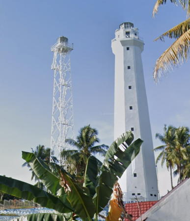
Date unknown. Inactive since 2022 or 2023. 37 m (131 ft) skeletal tower with lantern and gallery, painted white. The lighthouse is near the left edge of a view from the sea and Google has a 2019 street view, a 2023 street view of the two lighthouses, and a satellite view. Located beside the new lighthouse (next entry). Site status unknown.
Tanjung Pasangkayu (Pasaugkajoe) (2)
2022-23. Active; focal plane 56 m (184 ft); three white flashes every 24 s. 37 m (131 ft) octagonal white concrete tower with lantern and gallery. Google has a 2023 street view (also seen at right) and a satellite view. Located on a promontory about 2.5 km (1.5 mi) west of Pasangkayu. Site status unknown. ARLHS IDO-044; Admiralty Q1484; NGA 25504.
 

Tanjung Pasangkayu Light, Pasangkayu, October 2023
Google Maps street view
 

Sulawesi Tengah (Central Sulawesi) Province West Coast Lighthouses

Despite its name Central Sulawesi Province is mostly in the northern part of the island; it includes the southern half of the long northern peninsula. Its west coast faces the Strait of Makassar and, to the north, the Celebes Sea. The population of the province is about 3 million. Lighthouses of the province's east coast are described on the Northeastern Sulawesi page.

Southern Donggala Regency (Palu Gulf) Lighthouses
Donggala Regency includes a long section of the the northwest coast of Sulawesi interrupted by the Palu Gulf, a long, narrow bay leading to the provincial capital of Palu.

* Teluk Palu (Tanjung Karang, Palu Gulf)
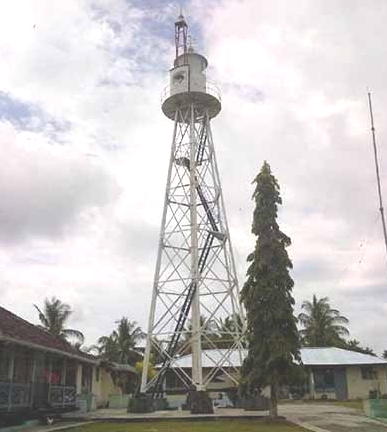
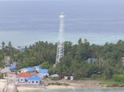
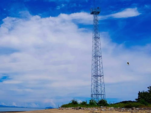
1907. Active; focal plane 82 m (269 ft); four long (2 s) white flashes every 25 s. 21 m (69 ft) hexagonal white iron skeletal tower with lantern and gallery. Several coast guard station buildings. A photo is at the top of this page, a 2018 closeup photo is available, Felix Ronaldi Rambi has a 2023 closeup, and Google has a good satellite view of the station. One of Indonesia's not-so-well-known Dutch lighthouses. Located on a prominent cape on the west side of the entrance to the narrow Palu Gulf, about 25 km (15 mi) northwest of Palu, the capital of Central Sulawesi. Site status unknown, but it should be possible to drive to this station from Palu. ARLHS IDO-339; Admiralty Q1476; NGA 25508.
Donggala
Date unknown. Active; focal plane 13 m (43 ft); white flash every 3 s. Approx. 10 m (30 ft) round white barbell-shaped tower on a square concretet base. Zaenudin Saktiwibowo has a 2021 closeup photo, Ipul Muis has a 2017 photo, Rob Ang has a street view, and Google has a satellite view. Located at the north end of the quay at Donggala, on the northwest coast of the Palu Gulf. Site status unknown. DSI-5111; Admiralty Q1478; NGA 25510.
Pantai Taipa (Taipa Beach)
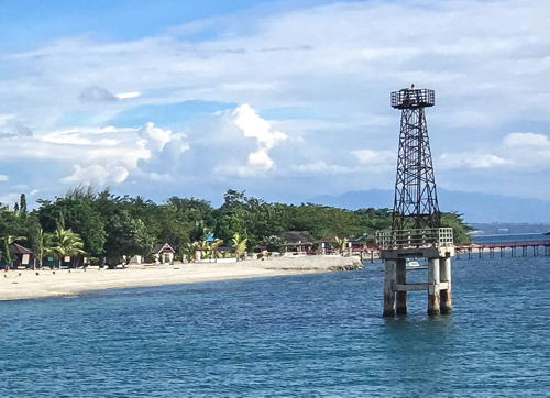
Date unknown. Apparently inactive. Approx. 15 m (49 ft) square skeletal tower mounted on a square platform supported by piles. Anastasiya Ivanova has a 2016 photo (a portion is seen at right), Miloslav Petrtyl has a 2017 photo, Wahyu Indra Sakti has a 2021 photo, Google has a 2016 street view, and Google has an indistinct satellite view. Located just offshore on the southeast coast of the Palu Gulf. Easily seen from shore. Site open, tower closed. ex-Admiralty Q1481.2.
Taipa Jetty (1 and 2)
Date unknown. Current light: focal plane 10 m (33 ft); white flash every 5 s. The original light was an approx. 13 m (43 ft) round barbell-shaped white fiberglass tower. Following the 2018 earthquake this light was in the water with a pronounced lean, as seen in a December 2019 photo and Mohamad Yani's June 2019 view from the sea. Google's satellite view shows that it is still present but has been replaced by a post light on the jetty. Located just north of the ferry pier at Taipa. Site open, tower closed. Admiralty Q1481.
* Pantoloan
Date unknown. Active; focal plane 18 m (59 ft); white flash every 5 s. 15 m (49 ft) square white skeletal tower mounted on a square white equipment shelter. A 2019 photo is available, the tower is the far right in a photo of the port by Bagus Roby and Google has an indistinct satellite view. NGA spells the name as Panteluan. Located at the south end of the quay at Pantoloan, a port on the east side of the Palu Gulf. Site open, tower closed. Admiralty Q1480; NGA 25512.

Pantai Taipa Light, Palu Gulf, November 2016
ex-Google Plus photo by Anastasia Ivanova

Northern Donggala Regency Lighthouses
Tanjung Manimbaya
Date unknown. Active; focal plane 50 m (164 ft); two white flashes every 20 s. 40 m (131 ft) square skeletal tower with lantern and gallery; tower painted white, lantern red. Three coast guard station buildings. A 2017 closeup photo and a 2020 photo are available and Google has a satellite view of the station. This lighthouse is built almost precisely on the Equator. Located at the tip of a long promontory extending into the Strait of Makassar about 30 km (19 mi) northwest of Mapaga. Site status unknown. DSI-5115; Admiralty F2040; NGA 25114.
Pulau Tuguan (Pulau Toguan, Pulau Tugguan, Noordwachter)
1902. Active; focal plane 92 m (302 ft); white flash every 5 s. 20 m (66 ft) hexagonal white iron skeletal tower with lantern and gallery. Sabar Petualangan has a 2019 photo of the station (also seen at right) and Bing has a satellite view of the station. This lighthouse marks the east side of the entrance to the Strait of Makassar from the Celebes Sea. Not to be confused with another, better known Noordwachter ("Northern Guard") in the Java Sea. Pulau Tuguan means "Monument Island." Located on an island in the strait about 25 m (15 mi) northwest of Munte in northwestern Sulawesi. Accessible only by boat. Site status unknown. ARLHS IDO-031; DSI-5120; Admiralty F2044; NGA 25120.
* Ogoamas (1)
Date unknown. Inactive since 2017. Approx. 16 m (52 ft) square white skeletal tower. Ahmad Djaya has a 2021 photo, the tower is near the left edge in Achmed Panguriseng's 2023 drone view, the top of the lighthouse is at the right in a February 2018 photo of the port by Ar Rahman Ar Rahim and Google has a satellite view. The light was moved to a much taller tower (next entry). Located near the base of the T-shaped pier at Ogoamas. Site open, tower closed.
* Ogoamas (2)
2017. Active; focal plane 35 m (115 ft); white flash every 3 s. Approx. 25 m (82 ft) square white skeletal tower. Salim Isme has a 2020 photo and Google has a street view and a satellite view. Located on the waterfront at Ogoamas. Site open, tower closed. Admiralty F2044.8.

Tolitoli Regency Lighthouses
Tolitoli Regency and Buol Regency occupy the northwestern corner of Sulawesi facing the Celebes (Sulawesi) Sea. The former Buol Tolitoli Regency was divided in 2000.

Tanjung Yaga (Pelabuhan Perikanan)
2019. Active; focal plane 19 m (62 ft); white flash every 15 s. 16 m (52 ft) square white skeletal tower. Iwan Saputra has a 2021 closeup photo and a view from the sea and Google has an indistinct satellite view. Located at Pelabuhan Perikanan, a new port on a mainland cape facing Pulau Lingian across a narrow strait. Site status unknown. Admiralty F2044.9.

Pulau Tuguan Light, Strait of Makassar, August 2019
Google Maps photo by Sabar Petualangan
Lingian
Date unknown. Active; focal plane 15 m (49 ft); white flash every 3 s. 15 m (49 ft) square white post or barbell-shaped tower mounted on a platform suported by piles. No photo available but Google has a distant satellite view. Located on the northwest tip of a large reef off Tanjung Aga, about 25 km (15 mi) southwest of Pulau Simatang. Accessible only by boat. Site open, tower closed. Admiralty F2045; NGA 25119.
* Pulau Simatang (Sematan)
Date unknown. Active; focal plane 31 m (102 ft); two white flashes every 8 s. Approx. 28 m (92 ft) square white skeletal tower. No photo available but Google has a satellite view. Located at the northern tip of Pulau Simatang. Accessible only by boat. Site status unknown but certainly the light can be seen from nearby, tower closed. Admiralty F2046; NGA 25118.
Pulau Kabetan (Pulau Kapetan, Tanjung Paligisan)
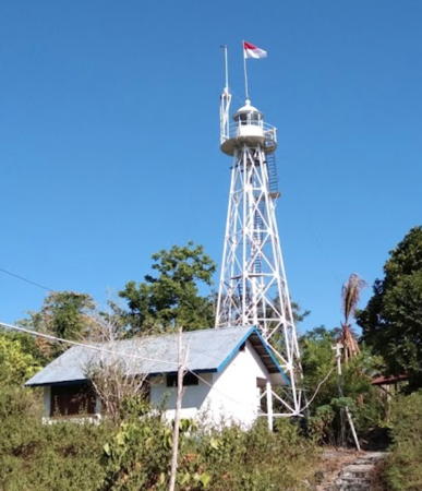
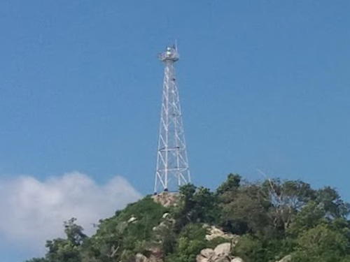
Date unknown. Active; focal plane 31 m (102 ft); white flash every 10 s. Approx. 28 m (92 ft) skeletal tower with gallery. Lighthouse painted white. A photo is at right, a 2021 photo is available, Fatur Mamat has a 2022 photo, a closeup is available, and Google has a satellite view. Located on the southeastern tip of Pulau Kabetan, an island on the approach to Botakna Bunga. Accessible only by boat. Site status unknown. Admiralty F2047; NGA 25121.
Pulau Lutungan
Date unknown. Active; focal plane 45 m (148 ft); two white flashes every 8 s. Approx. 25 m (82 ft) skeletal tower with gallery. Lighthouse painted white. No photo available but Google has a satellite view. NGA spells the name Latungan. Located at the northern tip of Pulau Lutungan, an island in the entrance to the harbor of Tolitoli. Accessible only by boat. Site status unknown. Admiralty F2047.5; NGA 25122.

Pulau Kabetan Light, Tolitoli
unattributed photo from identitastolitoli.com (no longer online)
* Tolitoli
Date unknown. Active; focal plane about 14 m (46 ft); green light, pattern unknown. Approx. 12 m (39 ft) skeletal tower, painted white. Ruci Helmi Reinaldhi has a 2024 street view and Google has a satellite view. Located at the older ferry terminal in Tolitoli. Site open, tower closed. Admiralty F2047.8.
* Tanjung Labuan Dedeh
Date unknown. Active; focal plane 16 m (52 ft); white flash every 3 s. 15 m (49 ft) skeletal tower, painted white. Novander Ulag has a photo, Denny Setiawan has a view from the sea, Hendra To has a 2021 drone view, and Google has a satellite view. Located at the newer ferry terminal in Tolitoli. Site open, tower closed. Admiralty F2048; NGA 25116.
Pulau Salando (Tanjung Malagka, Pulau Silando Timur, Stroomenkaap) (2)
Date unknown (station established 1913). Active; focal plane 57 m (187 ft); white flash every 5 s. 25 m (82 ft) white iron skeletal tower. Part of Paul Johan Lumatalale's 2018 view is at right and Google has an indistinct satellite view. This lighthouse marks the northeastern entrance to the Strait of Makassar. The original lighthouse had a focal plane height of 46 m (151 ft). Located on an island just off Tanjung (cape) Malagka, the northwestern corner of Sulawesi. Accessible only by boat. Site status unknown. ARLHS IDO-312; Admiralty F2050; NGA 25112.
Pulau Dolongan
Date unknown. Active; focal plane 23 m (75 ft); white flash every 6 s. 23 m (75 ft) square white skeletal tower mounted on a platform supported by piles. No photo available but Google has an indistinct satellite view. This light faces the Celebes Sea, marking the extreme northwest corner of Sulawesi. Located off the northern tip of an island about 10 km (6 mi) northeast of Tanjung Malagka. Site status unknown. Admiralty F2051; NGA 25111.7.

Pulau Salando Light, Tolitoli, May 2018
Google Maps photo by Paul Johan Lumatalale

Buol Regency Lighthouses
Tanjung Kandi
Date unknown. Active; focal plane 120 m (394 ft); three white flashes every 20 s. Approx. 65 m (213 ft) square skeletal tower with lantern and gallery. Lighthouse painted white, lantern red. Four 1-story station buildings. Simon Potter has a view from the sea (also seen at right) and Google has a good satellite view. Located on a very prominent cape about 65 km (40 mi) east of Pulau Dolongan. Site status unknown. Admiralty F2052; NGA 25113.
Teluk Bilang
Date unknown. Active; focal plane probably about 15 m (49 ft); white light, pattern unknown. No description available, presumably a white tower on a platform supported by piles. No photo available and the light is not shown in Google's satellite view. Located on a shoal marking the south side of the entrance to Bilang Bay, a harbor sheltered by Tanjung Kandi. Accessible only by boat. Site status unknown. Admiralty F2053.
* Leok
Date unknown. Active; focal plane 18 m (59 ft); white flash every 4 s. 15 m (49 ft) square white skeletal tower. Yonnas Grey has a view from the sea and Google has a 2024 street view and a satellite view. Located at the ferry terminal in Leok, a fishing port about 15 km (9 mi) south of Tanjung Kandi. Site open, tower closed. Admiralty F2054; NGA 25124.
* [Paleleh]
Date unknown. Active; focal plane about 10 m (33 ft); red light, pattern unknown. Approx. 8 m (26 ft) white post. Rudi Hartono has a distant view and Google has a street view and a fuzzy satellite view. Located at the ferry terminal at Paleleh, a small port at the eastern border of Central Sulawesi Province. Site open, tower closed. Admiralty F2056.

Information available on lost lighthouses:

Notable faux lighthouses:


Tanjung Kandi Light, April 2010
ex-Panoramio photo by Simon Potter

Adjoining pages: North: Northern Sulawesi | East: Northeastern Sulawesi | South: South Sulawesi Mainland | West: Eastern Kalimantan

Return to the Lighthouse Directory index | Ratings key

Posted December 18, 2008. Checked and revised June 15, 2024. Lighthouses: 48. Site copyright 2024 Russ Rowlett and the University of North Carolina at Chapel Hill.