Lighthouses of Indonesia: Northeastern Sulawesi (Celebes)

The Republic of Indonesia has been independent since 1945 after having been the Dutch East Indies for more than 350 years. It is a huge country, stretching along both sides of the Equator for more than 46 degrees of longitude (roughly 5100 km or 3200 miles). Comprised of some 17,000 islands (more than 6000 inhabited islands), it has hundreds of major aids to navigation.

Sulawesi (Celebes) is a major island in the northern part of the country. Shaped like an artistically drawn letter K, Sulawesi consists mostly of four narrow peninsulas. The Makassar Strait separates Sulawesi from Kalimantan (Borneo) to the west. The Celebes Sea is north of the island, the Molucca Sea is on the northeast, the Banda Sea is to the southeast, and the Flores Sea is on the south.

Indonesia is divided into 34 provinces and the provinces are subdivided into regencies (kabupaten). This page includes lighthouses on the east side of the island facing the Gulf of Tomini in the northern half of Sulawesi Tengah (Central Sulawesi) Province. Lighthouses on the east side of the island facing the Banda Sea in the southern half of the province are described on the Eastern Sulawesi page. The province also has a coast on the west side of the island; lighthouses on that coast are described on the Western Sulawesi page.

More than 700 languages are spoken in Indonesia. The official national language, Indonesian (Bahasa Indonesia), was standardized from a form of Malay that served as a lingua franca across the archipelago. In Indonesian a lighthouse is a mercusuar or a menara suar. Tanjung is a cape, ujung is a headland or point of land, bukit is a hill, sungai is a river, kuala or muara is an estuary or river mouth, pulau is an island, karang is a reef, batu is a rock, laut is a sea, selat is a strait, teluk is a bay, pelabuhan is a harbor, and labuhan is a port.

Aids to navigation in Indonesia are operated and maintained by the Directorate of Marine Navigation within the Directorate General of Sea Transportation.

ARLHS numbers are from the ARLHS World List of Lights. Admiralty numbers are from volumes F and Q of the Admiralty List of Lights & Fog Signals. U.S. NGA List numbers are from Publication 112.

General Sources
Online List of Lights - Indonesia - Sulawesi - Vol. F and Vol. Q
Photos by various photographers posted by Alexander Trabas. Lights in Volume F are north of the Equator and those in Volume Q are south of the Equator.
Indonesian Lighthouses
Historic postcard views from the collection of Michel Forand.
World of Lighthouses - Indonesia
Photos by various photographers available from Lightphotos.net.
Sulawesi Map
A useful map from orangesmile.com.
Navionics Charts
Navigation chart for Sulawesi.

Ampana Light, Ampana, November 2017
ex-Google Plus photo by Arlin Windaryanti
Parigi Moutong Regency Lighthouses
Parigi Moutong is a narrow coastal regency that curves in a semicircle around the west end of the Gulf of Tomini, the gulf separating the Minnehasa (North) Peninsula and the East Peninsula of Sulawesi.

* Moutong (Mautang)
Date unknown. Active; focal plane 12 m (39 ft); continuous red light. 12 m (39 ft) square white skeletal tower with gallery. A 2022 photo is available, Kurniawan Stell has a 2021 distant view, and Google has an indistinct satellite view. Located near the quay at Moutong, a village on the central north coast of the Gulf of Tomini. Site open, tower closed. Admiralty F2086; NGA 25236.
Pulau Panabean
Date unknown. Active; focal plane 31 m (102 ft); two white flashes every 8 s. Approx. 28 m (92 ft) skeletal tower apparently with lantern, gallery and a central cylinder. No photo available but Bing has a satellite view. Located on a dangerous reef in the Gulf of Tomini about 23 km (14 mi) south of Moutong. Accessible only by boat. Site open, tower closed. Admiralty F2086.5; NGA 25238.
Tomini
Around 2016. Active; focal plane 14 m (46 ft); two white flashes every 8 s. Approx. 12 m (39 ft) square skeletal tower. Google has a distant street view but the tower is not seen in Google's satellite view. Located in or near the village of Tomini on the northwestern coast of the Gulf. Site status unknown. Admiralty F2087; NGA 25237.
* Tinombo
2016. Active; focal plane 15 m (49 ft); white flash every 3 s. 12 m (39 ft) square white skeletal tower with gallery. Yanti Ilham has a 2023 photo and Google has a street view and a satellite view. Located at the quay at Tinombo, a town on the northwestern coast of the Gulf of Tomini. Site open, tower closed. Admiralty F2087.5.
Karang Ampibabo
Date unknown. Active; focal plane 15 m (49 ft); white flash every 3 s. 15 m (49 ft) white skeletal tower mounted on a platform supported by piles. No photo available but Google has a satellite view. Located at the south end of long reef off the village of Ampibabo at the extreme west end of the Gulf of Tomini. Accessible only by boat. Site open, tower closed. Admiralty Q1576.8.
* Paranggi
Date unknown. Active; focal plane about 20 m (66 ft); light characteristic unknown. Yeremia Apridianto has the 2022 photo seen at right, a 2021 photo is avilable, and Google has a satellite view and a distant street view. Located on the waterfront of Paranggi, the harbor district of Ampibabo. Site open, tower closed. Not listed by the Admiralty.

Paranggi Light, Ampibabo, June 2022
Google Maps photo by Yeremia Apridianto
Karang Rode Loji
Date unknown. Active; focal plane about 14 m (46 ft); quick-flashing white light. Approx. 14 m (46 ft) skeletal tower mounted on a platform supported by piles. Upper half of the tower painted black, lower half yellow. No photo available but Bing has a satellite view. Located on a reef about 8 km (5 mi) northeast of Parigi. Accessible only by boat. Site open, tower closed. Admiralty Q1576.5.
* Parigi (Logi) (2)
Date unknown. Active; focal plane about 32 m (105 ft); white flash every 7 s. Approx. 30 m (98 ft) tapered square white skeletal tower. Farid Rohman Sholeh has a 2016 photo, the tower is seen at the far left in Muh Fadjar's photo, Who Naski has a 2022 view from the sea, and Google has the street view seen at right and a satellite view. NGA lists a 7 m (23 ft) tower said to be "on the beach." Located behind the ferry terminal at Parigi, the regency capital, on the southwestern shore of the Gulf of Tomini. Site open, tower closed. Admiralty Q1576; NGA 25240.
Pasir Laut
Date unknown. Active; focal plane 16 m (52 ft); white flash every 3 s. Approx. 14 m (46 ft) "white beacon," probably a square white skeletal tower. No photo available and the light is not shown in Google's satellite view. This light marks a reef in the entrance to the southwestern bay of the Gulf of Tomini, the Pasir Laut ("Sand Sea"). Located about 100 km (60 mi) north of Poso. Accessible only by boat. Site open, tower closed. Admiralty Q1573.5.

Poso Regency Lighthouse
Poso is a city of nearly 50,000 residents and an important regional port at the southwestern corner of the Gulf of Tomini.

Poso Fuel Depot
Date unknown. Active; focal plane 10 m (33 ft); white flash every 5 s. 9 m (30 ft) square white skeletal tower. The light is a little to the right of center in Moh Akbar Ladjada's 2024 aerial view and Google has a satellite view. Located at the Pertamina oil terminal about 6 km (4 mi) west of Poso. Site and tower closed. Admiralty Q1575; NGA 25244.
* Poso
Date unknown. Active; focal plane 16 m (52 ft); white light, 2 s on, 1 s off. 15 m (49 ft) square white skeletal tower. In a 2023 photo the light is on the right, partly hidden by the building. Google has a street view and a satellite view. Located at the ferry terminal at Poso. Site open, tower closed. Admiralty Q1574; NGA 25248.

Parigi Light, Parigi, November 2021
Google Maps street view

Tojo Una-Una Regency: Mainland Lighthouses
Tojo Una-Una Regency includes the central south coast of the Gulf of Tomini and the Togian Islands, an archipelago in the center of the Gulf. Ampana, the regency capital, is a mainland town with a population of about 45,000.
* Ampana
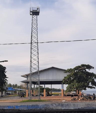
Date unknown. Active; focal plane 10 m (33 ft); white flash every 3 s. 10 m (33 ft) square white skeletal tower. Arlin Windaryanti has a 2017 photo (a portion appears at the top of this page) and Google has a 2023 street view and an indistinct satellite view. Located on the quay at Ampana, a town on the south shore of the Gulf of Tomini. Site open, tower closed. Admiralty Q1572.8.
Ampana Fuel Depot
Date unknown. Active; focal plane about 12 m (39 ft); flashing white light, pattern unknown. Approx. 10 m (33 ft) square white skeletal tower. Two sides of the tower are covered by white daymark panels. Wahyu Hidayat has a photo and Google has a satellite view. Located at the oil depot on the northeast side of Ampana. Site and tower closed. Admiralty Q1573.
Uebone
Date unknown. Active; focal plane about 20 m (66 ft); light characteristic unknown. Approx. 17 m (56 ft) square skeletal tower. Sabeeque Rozzan has a distant 2023 photo, Iwan Rusly has a sunrise 2022 photo, and Google has a distant street view and an indistinct satellite view. Located at the Uebone ferry terminal, about 10 km (6 mi) southeast of Ampana. Site status unknown. Not listed by the Admiralty.
* Mangtangisi
2019. Active; focal plane focal plane 20 m (66 ft); white flash every 3 s. 15 m (49 ft) square white skeletal tower. Google has a street view (a portion is seen at right), Husmin Fajrin's 2024 video shows the lighthouse, and the tower is near the left edge of a 2019 photo but the tower is apparently too new to appear in Bing's satellite view. Located at Barang Mangtangisi, a new port under development about 25 km (15 mi) east of Ampana. Site open, tower closed. Admiralty Q1572.65.

Tojo Una-Una Regency: Togian Islands Lighthouses
Pulau Bukabuka
Date unknown. Active; focal plane 15 m (49 ft); white flash every 7 s. Approx. 12 m (39 ft) square white skeletal tower. A distant aerial view is available (lighthouse on the point, left of center) and Google has a satellite view. Located on the northern tip of Pulau Bukabuka, an island midway between the mainland and the western end of the Togian Islands. Site status unknown. Admiralty Q1572.7; NGA 25261.
Pasir Tengah (Middle Sand)
Date unknown. Active; focal plane 15 m (49 ft); white flash every 4 s. 15 m (49 ft) white tower on a platform supported by piles. No photo available but Bing has a satellite view. Located at the north end of a sandy reef about 10 km (6 mi) north of Pulau Batudaka, the westernmost of the Togian Islands. Accessible only by boat. Site open, tower closed. Admiralty Q1578; NGA 25239.

Mangtangisi Light, Ampana, Sepetmber 2021
Google Maps street view
Pulau Una-Una
Date unknown. Active; focal plane 13 m (43 ft); white flash every 3 s. Approx. 10 m (33 ft) square white skeletal tower. No photo available but Google has an indistinct satellite view. Una-Una is an isolated volcanic island north of the Togian Islands in the Gulf of Tomini; the Colo volcano that forms the island erupted in 1983. Located at the foot of the pier at the settlement on the east side of the island. Site open, tower closed. Admiralty Q1577; NGA 25238.5.
* Wakai
Date unknown. Active; focal plane 16 m (52 ft); white flash every 3 s. Approx. 14 m (46 ft) square white skeletal tower mounted on a square white 1-story equipment building. Edi Yamin has a 2018 view, the top of the tower is seen over the building in Lasahido Saleh's photo, Daniel van Hauten has a fuzzy street view, and Google has a satellite view. Located on the quay at Wakai, a fishing port at the northeastern corner of Pulau Batudaka, the westernmost of the Togian Islands. Site open, tower closed. Admiralty Q1579.
Malenge
2019(?). Active; focal plane 20 m (66 ft); white flash every 3 s. 15 m (49 ft) square white skeletal tower. No photo available and the tower is probably too new to appear in Bing's partially-clouded satellite view. Located on the waterfront of Malenge, a village on Pulau Malenge, an island on the north side of the Togian Islands. Site probably open, tower closed. Admiralty Q1579.5.
Tanjung Komali (Komnali)
Date unknown. Active; focal plane 50 m (164 ft); two white flashes every 8 s. Approx. 15 m (49 ft) square white skeletal tower. No photo available but Bing has an indistinct satellite view. This light guides vessels entering the Gulf of Tomini from the south. Located on the northwestern tip of Pulau Waleabahi, the easternmost of the Togian Islands. Site status unknown. Admiralty Q1580; NGA 25262.
Selat Walera (Walera Strait)
Date unknown. Active; focal plane 19 m (62 ft); three white flashes every 20 s. 13 m (43 ft) square white skeletal tower mounted on a platform supported by piles. No photo available but Bing has a satellite view. This light guides vessels in a narrow passage through a reef connecting the southeast end of the Togian Islands and the mainland. Accessible only by boat. Site open, tower closed. Admiralty Q1572; NGA 25260.

Banggai Regency: North Coast Lighthouses
Banggai Regency occupies the eastern 2/3 of the Northeast Peninsula of Sulawesi. Lighthouses on the south coast of the regency are described on the Eastern Sulawesi page.

* Bunta
Date unknown. Active; focal plane 16 m (52 ft); continuous red light. 15 m (49 ft) square white skeletal tower. Syahir Ihwar has a closeup photo (also seen at right), M. Nurul Falah has a 2023 evening view, and Google has a distant satellite view. Located at the ferry terminal at Bunta, a town on the mainland opposite the Togian Islands. Site open, tower closed. Admiralty Q1572.6.

Bunta Light, Bunta, May 2017
Google Maps photo by Syahir Ihwar
Pagimana
Date unknown. Active; focal plane 40 m (131 ft); two white flashes every 8 s. Approx. 25 m (82 ft) square skeletal tower. Google has the 2021 street view seen at right and a satellite view. This appears to be an appropriate tower for this light; it does not match the location listed by the Admiralty but does agree with the position charted by C-Map. Located on a bluff behind the waterfront of Pagimana. Site status unknown. Admiralty Q1572.4; NGA 25258.
Pagimana West
Date unknown. Active (?); focal plane about 15 m (49 ft); light characteristic unknown; charted as unlit but it appears active. Approx. 21 m (69 ft) square skeletal tower mounted on a platform supported by piles. Seen in the foreground at the right edge of a photo by Jemmy Dimitrius and Google has a satellite view. Located on a shoal just off the waterfront at Pagimana. Accessible only by boat. Site open, tower closed. Not listed by the Admiralty.
Karang Pagimana (2)
Date unknown. Active; focal plane about 15 m (49 ft); red flash every 4 s. Approx. 14 m (46 ft) square skeletal tower mounted on a platform supported by piles. Seen in the distance at the right edge of a photo by Jemmy Dimitrius, Hindun Effendy has a distant view from shore, and Google has a satellite view. Located at the west end of a shoal about 400 m (1/4 mi) off the ferry port at Pagimana. Accessible only by boat. Site open, tower closed. Admiralty Q1572.5; NGA 25248.5.
* Pelabuhan Pagimana
Date unknown. Active; focal plane about 16 m (52 ft); white light, characteristic unknown. Approx. 14 m (46 ft) square white skeletal tower mounted on a square white 1-story equipment building. Kasvili Mangerongkonda has a photo, Fendi Sky has a 2018 photo, Hindun Effendy has a 2023 view, Ronald Rumampuk has a street view, and Google has an indistinct satellite view. Located at the port authority regional office adjacent to the ferry terminal at Pagimana. Site open, tower closed. Not listed by the Admiralty.
Tanjung Batuhitam (Pulau Tinalapu)
2019(?). Active; focal plane 16 m (52 ft); white flash every 3 s. 16 m (52 ft) square white skeletal tower mounted on a platform supported by piles. No photo available but Google has a satellite view. The light marks a narrow passage around a very prominent cape. Accessible only by boat. Site open, tower closed. Admiralty Q1572.2.

Pagimana Light, Pagimana, October 2021
Google Maps street view
Pulau Pasir ("Sand Island")
Date unknown. Active; focal plane 15 m (49 ft); white flash every 6 s. 15 m (49 ft) square skeletal tower on a platform supported by piles. No photo available but Bing has a satellite view. The light and the next one mark openings in a long reef extending northwest from the end of the East Peninsula of Sulawesi. Located on a reef about 25 km (15 mi) north of the east end of the peninsula. Accessible only by boat. Site open, tower closed. Admiralty Q1571.5; NGA 25260.2.
Pulau Sendiri
Date unknown. Active; focal plane 15 m (49 ft); two white flashes every 6 s. 15 m (49 ft) "white beacon," probably a square skeletal tower on a platform supported by piles. No photo available but Bing has a distant satellite view. The light and the previous one mark openings in a long reef extending northwest from the end of the East Peninsula of Sulawesi. NGA misspells the name as Sensiri. Located on a reef abour 15 km (9 mi) north of the east end of the peninsula and 15 km (9 mi) east of Pulau Pasir. Accessible only by boat. Site open, tower closed. Admiralty Q1571; NGA 25260.5.

Information available on lost lighthouses:

Notable faux lighthouses:

Adjoining pages: North: Northern Sulawesi | East: North Maluku | Southeast: Central Maluku | South: Eastern Sulawesi | West: Western Sulawesi

Return to the Lighthouse Directory index | Ratings key

Posted December 18, 2008. Checked and revised July 8, 2024. Lighthouses: 30. Site copyright 2024 Russ Rowlett and the University of North Carolina at Chapel Hill.