Lighthouses of Japan: Awaji Shima

The nation of Japan, known in Japanese as Nihon or Nippon (日本), occupies an archipelago off the east coast of Asia. The four main islands are Hokkaidō in the north, Honshū (the largest) in the center, Shikoku in the south, and Kyūshū in the southwest. The country includes thousands of other islands of all sizes; among them the Ryūkyū (Nansei) Islands are a long chain extending to the southwest and including the large island of Okinawa, and the Nanpō Islands are another long chain extending south into the Pacific Ocean. Much of Japan is mountainous but the coastal regions are densely populated and urbanized; the country's population is about 126 million.

Japan is divided into 47 prefectures. Awaji is a large island of Hyōgo Prefecture in central Japan. Awaji is about 105 km (66 mi) long, stretching across the eastern end of the Seto Inland Sea (Seto Naikai) south of Kōbe. About 160,000 people live on the island. The northeastern end of Awaji is separated from Honshū by the narrow Akashi Strait, while the southwestern end is separated from Shikoku by the even more narrow Naruto Strait. The Kōbe-Awaji-Naruto Expressway crosses the island lengthwise and provides a high-speed link between Shikoku and Honshū. The expressway crosses the Akashi Strait by the Akashi Kaikyō Bridge, which currently has the world's second longest suspension span (1991 m or 6532 ft). Ōsaka Bay is the portion of the Seto Inland Sea to the east of Awaji, and Harima Bay is on the west.

In Japanese the word for a lighthouse is tōdai or toudai (灯台). The words saki and misaki are for capes and headlands, hana ("nose") is a promontory, hantō is a peninsula, shima (also spelled sima or jima) is an island, bae is a reef, iwa or shi is a rocky reef, amase or se is a shoal, wan is a bay, nada is a sound or basin, kaikyō is a strait, kawa is a river, and or minato is a harbor.

Lighthouses in Japan are operated and maintained by the Japanese Coast Guard's Maritime Safety Agency. On Honshū there is at least one Coast Guard Section Office in each prefecture, often two. The lighthouses of Awaji Shima are maintained by the Kōbe office.

ARLHS numbers are from the ARLHS World List of Lights. JCG numbers are the Japanese Coast Guard's light list numbers. Admiralty numbers are from volume M of the Admiralty List of Lights & Fog Signals. U.S. NGA List numbers are from Publication 112.

General Sources
Lighthouses in Japan - Hyōgo
A site providing photos and data for most major Japanese lighthouses.
Lighthouse-Japan.com - Hyōgo
Another comprehensive site with photos and notes from visits to many lighthouses.
Form of a Lighthouse - Hyōgo
Another site with many photos of Japanese lighthouses and notes on how to find them; cited below as FOAL.
Kiso's Lighthouses
This site has many excellent photos of Japanese lighthouses.
Misty's Japanese Lighthouse Tour - Hyōgo
Photos and a few notes for lighthouses in all parts of the country.
Online List of Lights - Japan
Photos by various photographers posted by Alexander Trabas.
Lighthouses in Hyōgo Prefecture
Photos by various photographers available from Wikimedia.
Richard Henry Brunton
Wikipedia article on the Scottish engineer who built most of Japan's oldest lighthouses.
Japan: Modern Lighthouses
Historic postcard views posted by Michel Forand.
Navionics Charts
Navigation chart for the Inland Sea.


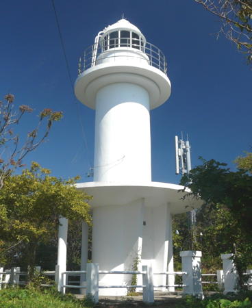
Numa Shima Light, Minamiawaji, July 2020
Instagram photo by kutakutatoto
Awaji City Lighthouses
Awaji City occupies the northern half of Awaji Shima; it has a population of about 45,000.

* Gunge (Gunke) Kō
Date unknown (station established 1929). Active; focal plane 12 m (39 ft); continuous red light with a more intense flash every 3 s. 9 m (30 ft) concrete post rising from a square 1-story concrete service building. Entire lighthouse is red. Trabas has a closeup photo, FOAL's page has photos, and Google has a street view and a satellite view. Located at the end of the main breakwater of Gunge, a small port on the northwestern coast of Awaji Shima. Accessible by walking the pier. Site open, tower closed. ARLHS JPN-1776; JCG-3958; Admiralty M5800; NGA 7952.
* Ozaki Kō
1979. Active; focal plane 12 m (39 ft); red light, 2 s on, 2 s off. 9 m (30 ft) concrete post rising from a square 1-story concrete service building. Entire lighthouse is red. Trabas has a closeup photo, FOAL's page has photos, and Google has a street view and a satellite view. Located at the end of the west (outer) breakwater of Ozaki. Accessible by walking the pier. Site open, tower closed. ARLHS JPN-1787; JCG-3959; Admiralty M5799.5; NGA 7956.
* Awaji (Murotsu) Kō
1965. Active; focal plane 13 m (43 ft); continuous red light with a more intense flash every 7 s. 9 m (30 ft) concrete post rising from a square 1-story concrete service building. Entire lighthouse is red. Trabas has a closeup photo, FOAL's page has photos, and Google has a street view and a satellite view. Located at the end of the main breakwater of the Morotsu harbor of Awaji. Accessible by walking the pier. Site open, tower closed. ARLHS JPN-1774; JCG-3957; Admiralty M5799; NGA 7948.
Ikuha Kō
Date unknown. Active; focal plane 12 m (39 ft); red flash every 5 s. 8.5 m (28 ft) concrete post rising from a square 1-story concrete service building. Entire lighthouse is red. Trabas has a closeup photo, FOAL's page has photos, and Google has a street view and a satellite view. Located at the east end of the detached breakwater of the Ikuha harbor of Awaji. Accessible only by boat. Site open, tower closed. JCG-3956; Admiralty M5798.6; NGA 7944.
* Toshima (Tosima) Kō
1956. Active; focal plane 13 m (43 ft); red light, 2 s on, 2 s off. 10 m (33 ft) round concrete tower, flared at the top and attached to a small equipment shelter. Entire lighthouse is red. Trabas has a closeup photo, FOAL's page has photos, Takahiro Ueoka has a 2023 view, and Google has a street view and a satellite view. Located at the end of the main breakwater of the Toshima harbor of Awaji. Accessible by walking the pier. Site open, tower closed. ARLHS JPN-1796; JCG-3954; Admiralty M5797; NGA 7936.
* E Saki
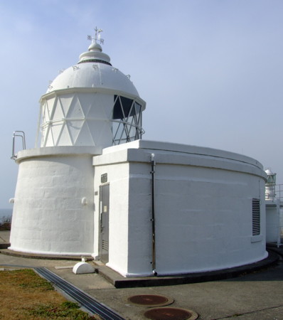
1871 (Richard Henry Brunton). Active; focal plane 49 m (161 ft); flash every 5 s, alternately red and white. 8 m (26 ft) round stone tower with lantern and gallery, surrounded on one side by a semicircular 1-story keeper's house. Entire lighthouse painted white. A 2nd order Fresnel lens is in use. A photo is at right, Lighthouse-Japan.com has a page with several photos, Trabas has a closeup photo, FOAL's page has excellent photos, Misty's Tour has a nighttime photo, Sada Sumi has a 2022 photo, and Google has a 2022 street view and a satellite view. This is one of Japan's oldest active lighthouses and an important historic site. The lighthouse was carefully repaired after being damaged by the great earthquake of 17 January 1995, which caused heavy damage throughout Awaji and the Kōbe area. The smaller lighthouse at the foot of the bluff, seen in a Google street view, is a faux lighthouse decorating a small park (according to FOAL it has a decorative blue neon light). Located on a bluff above the northernmost point of Awaji, a short distance west of the Akashi Kaikyō Bridge. Limited parking is available but it's a steep climb up many steps to the lighthouse. Site open, tower closed. . ARLHS JPN-056; JCG-3801; Admiralty M5796; NGA 7648.
Iwaya Kō Inner Breakwater
Date unknown. Active; focal plane 13 m (43 ft); red flash every 4 s. 9.5 m (31 ft) round concrete tower, flared at the top, attached to a small equipment shelter. Entire lighthouse is red. A photo is available, Trabas has a closeup photo and Google has a satellite view. Located at the east end of the inner breakwater of Iwaya, opposite the Outer Breakwater light. Accessible only by boat. Site open, tower closed. ARLHS JPN-1777; JCG-3714; Admiralty M5834; NGA 7640.
E Saki Light
E Saki Light, Awaji, January 2011
Wikimedia Creative Commons photo by Pinqui
Iwaya Kō Outer Breakwater
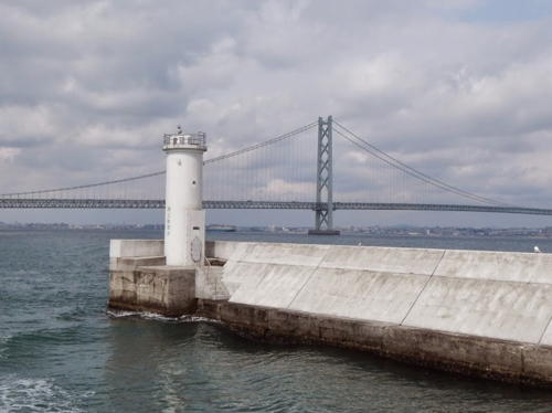
Date unknown. Active; focal plane 12 m (39 ft); green flash every 3 s. 10 m (33 ft) round cylindrical concrete tower, painted white. A photo (also seen at right) is available, Trabas has a closeup photo and Google has a satellite view. Located at the end of the detached west breakwater of Iwaya, a small boats port about 1.5 km (1 mi) southeast of the Akashi Kaikyō Bridge. Accessible only by boat. Site open, tower closed. ARLHS JPN-1778; JCG-3715; Admiralty M5834.2; NGA 7644.
* Ura Kō South Breakwater
1963. Active; focal plane 11 m (36 ft); green light, 2 s on, 2 s off. 8 m (26 ft) round hourglass-shaped white concrete tower. Trabas has a closeup photo, FOAL's page has photos, a 2022 photo is available, and Google has a street view and a satellite view. Located at the end of the main breakwater of Ura Kō, a small harbor about 13 km (8 mi) south of the Akashi Kaikyō Bridge. Accessible by walking the pier. Site open, tower closed. ARLHS JPN-1799; JCG-3711; Admiralty M5828; NGA 7628.
Kariya Kō East Breakwater
Date unknown. Active; focal plane 13 m (43 ft); green flash every 3 s. 8.5 m (28 ft) square concrete post rising from a square 1-story concrete service building. Entire lighthouse is white. Trabas has a closeup photo and Google has a satellite view and a distant street view. Located at the end of the detached east breakwater at Kariya. Accessible only by boat. Site open, tower closed. ARLHS JPN-1779; JCG-3701; Admiralty M5822.8; NGA 7624.
* Kariya Kō South Breakwater
Date unknown. Active; focal plane 12 m (39 ft); green light, 3 s on, 3 s off. 8.5 m (28 ft) square concrete post rising from a square 1-story concrete service building. Entire lighthouse is white. Trabas has a closeup photo, a 2023 photo is available, and Google has a street view and a satellite view. Located at the end of the south breakwater at Kariya. Accessible by walking the pier. Site open, tower closed. ARLHS JPN-1780; JCG-3700; Admiralty M5822.6; NGA 7620.

Iwaya Kō Outer Breakwater, Awaji, March 2015
Google Maps photo by Mission Specialist
* Sano Minami (Sanoniijima)
Date unknown. Active; focal plane 11 m (36 ft); green light occulting once every 4 s. 9 m (30 ft) round concrete post rising from a square 1-story concrete service building. Entire lighthouse is white. Trabas has a closeup photo and Google has a satellite view and a distant street view. Located at the end of a short breakwater extending from the north end of Sanoniijima, a mostly-artificial island on the north side of Tsuno. Accessible by walking the pier. Site open, tower closed. ARLHS JPN-1788; JCG-3699; Admiralty M5822.4; NGA 7616.
Tsuno (Tuno) Kō Ikuho East Breakwater
Date unknown. Active; focal plane 11 m (36 ft); green flash every 3 s. 8.5 m (28 ft) concrete post rising from a square 1-story concrete service building. Entire lighthouse is white. Trabas has a closeup photo, Takashi Izumi has a distant 2022 view, and Google has a satellite view and a very distant street view. Tsuno Kō is a port district that extends for almost 8 km (5 mi) along the east coast of Awaji. Located on a detached breakwater at the entrance to the Ikuho basin of Tsuno Kō. Accessible only by boat. Site status unknown. JCG-3698; Admiralty M5822.3; NGA 7612.
Tsuno (Tuno) Kō Shizuki South Breakwater
Date unknown. Active; focal plane 12 m (39 ft); two green flashes every 7 s. 8.5 m (28 ft) concrete post rising from a square 1-story concrete service building. Entire lighthouse is white. FOAL's page has photos (second row right and last row left), Trabas has a closeup photo, a 2023 photo is available, and Google has a street view and a satellite view. Located at the end of the south breakwater of the Shizuki basin of Tsuno Kō. Site status unknown. ARLHS JPN-1789; JCG-3695; Admiralty M5822.16; NGA 7604.
Tsuno (Tuno) Kō Shiota South Breakwater
Date unknown. Active; focal plane 12 m (39 ft); continuous green light with three more intense flashes every 13 s. 8.5 m (28 ft) concrete post rising from a square 1-story concrete service building. Entire lighthouse is white. FOAL's page has photos, Trabas has a closeup photo, a 2023 photo is available, and Google has a satellite view and a distant street view. This lighthouse was relocated around 2013 to a new detached breakwater, off the end of the south breakwater of the Shiota basin of Tsuno Kō. Accessible only by boat. Site status unknown. ARLHS JPN-1790; JCG-3694; Admiralty M5822.12; NGA 7600.

Sumoto City East Coast (Taka Saki Area) Lighthouses
Sumuto spans across the central portion of Awaji Shima. Like Awaji City, it has about 45,000 residents.

Awaji Yura Kō
Date unknown. Active; focal plane 11 m (36 ft); continuous green light with a more intense flash every 6 s. 8.5 m (28 ft) concrete post rising from a square 1-story concrete service building. Entire lighthouse is white. Trabas has a closeup photo and Google has a satellite view and a distant street view. Located on a short breakwater protecting the east side of Yura harbor. Site status unknown. ARLHS JPN-1800; JCG-3685; Admiralty M5816; NGA 7528.
Naruyama (Naruga) Shima
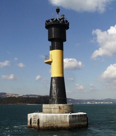
Date unknown. Active; focal plane 19 m (62 ft); three quick white flashes every 10 s. 17 m (56 ft) round hourglass-shaped concrete tower mounted on an octagonal concrete pier. Lighthouse painted black with a broad yellow horizontal band. A Coast Guard photo is at right, Trabas has a photo, FOAL has a photo (seventh row left), and Google has a satellite view. Located in the water off Naruyama Shima, on the east side of Awaji about 1.6 km (1 mi) due north of Taka Saki. Accessible only by boat. Site and tower closed. JCG-3684; Admiralty M5815.5; NGA 7524.
Naruga Shima Light
Nurayama Shima Light, Sumoto
Japanese Coast Guard Fifth Region photo
Taka Saki
Date unknown (1970s?). Active; focal plane 28 m (92 ft); white light occulting once every 4 s. 10 m (33 ft) round hourglass-shaped concrete tower, painted white. Lighthouse-Japan.com has a page with a photo, Trabas has a photo, FOAL has a photo (seventh row right). Misty's Tour has photos taken from the sea, and Google has a satellite view. This lighthouse and the Tomoga Shima lighthouse (see the Northern Wakayama page) frame the westernmost entrance to Ōsaka Bay from the Kii Strait. Located at the southern tip of a small island just off the southeasternmost point of Awaji. Site status unknown, but probably accessible; tower closed. . ARLHS JPN-610; JCG-3683; Admiralty M5815; NGA 7520.
* Oishino (Oisino) Hana
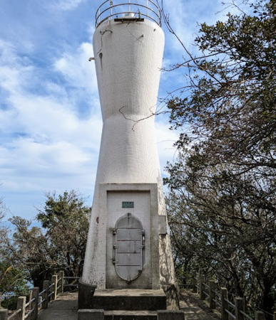
1974. Active; focal plane 118 m (387 ft); white flash every 5 s. 10 m (33 ft) round hourglass-shaped concrete tower, painted white. The tower also carries a spotlight (JCG-3682) that illuminates a nearby reef. K. Hikaru's 2023 photo is at right, Lighthouse-Japan.com has a page with a photo, Trabas has a closeup photo, Wikimedia has a photo, FOAL's page has photos (top of the page), a closeup photo is available, Misty's Tour has additional photos, and Google has a satellite view. This light and the Taka Saki light seem to be a pair. The lighthouse is in Oishi Park, a unit of the Setonaikai National Park. Located on the heights above and about 1.2 km (3/4 mi) to the southwest of Taka Saki. Accessible by road, but the entrance is marked only by a small sign. Parking is available about 300 m (0.2 mi) away at the end of the road. Site open, tower closed. . ARLHS JPN-476; JCG-3681; Admiralty M5814.6; NGA 7516.

Minamiawaji City (Naruto Strait) Lighthouses
Minamiawaji (South Awaji) occupies the southern end of Awaji Shima.

Nu (Numa) Shima (Nushima)
1961. Active; focal plane 133 m (436 ft); white flash every 10 s. 12 m (39 ft) round cylindrical concrete tower with lantern and gallery, painted white. A 2020 photo is at the top of this page, Lighthouse Japan.com has a page with several photos, FOAL's page has good photos, Kazuhiro Yasui has a 2020 photo, Misty's Tour has additional photos, Trabas has a distant view, and Google has a satellite view. Nu Shima is a small island in the Kii Strait about 4 km (2.5 mi) south of Awaji's southern coast. The island is inhabited and boat transportation is available, but it's a substantial hike to the lighthouse. Located on the highest point of the island. Site open, tower closed. . ARLHS JPN-438; JCG-3461; Admiralty M5570; NGA 7184.
* Nikoro (Niko) Kō
Date unknown. Active; focal plane 12 m (39 ft); green flash every 3 s. 9.5 m (31 ft) round concrete tower with a flared top attached to a small 1-story concrete equipment shelter. Entire lighthouse is white. Trabas has a closeup photo, Ryuuichi Sugimoto has a 2022 photo, and Google has a satellite view. Located at a small harbor near the southern tip of Awaji Shima. Accessible by walking the pier. Site open, tower closed. JCG-3460.5; Admiralty M5814.25; NGA 7183.

Oishino Hana Light, Sumoto, March 2023
Google Maps photo by K. Hikaru
Fukura (Hukura) Kō
Date unknown. Active; focal plane 9 m (30 ft); green flash every 3 s. 8.5 m (28 ft) concrete post attached to a square 1-story concrete equipment shelter. Entire lighthouse is white. Chihiro Okada has a photo, Trabas has a photo, FOAL has photos, and Bing has an indistinct satellite view. This light seems to have been dropped by the Admiralty but according to FOAL it is still active. Located on the east side of Kemuri Shima, a small island in the entrance to Fukura harbor. Accessible only by boat. Site open, tower closed. JCG-3460; ex-Admiralty M5814; NGA 7180.
* Tarushima (Tsurishima) Hana
1955. Active; focal plane 26 m (85 ft); white flash every 3 s. 9.5 m (31 ft) round concrete tower rising from a round 1-story equipment room. Entire lighthouse is white. Lighthouse-Japan.com has a page with several photos, Misty's Tour has additional photos, Trabas has a photo, a closeup is available, and Google has a satellite view. Located on a promontory marking the north side of the entrance to the harbor of Nandan from the Naruto Strait, at the southwestern end of Awaji. Accessible by a short hike but parking at the trailhead is limited. Site open, tower closed. . JCG-3459; Admiralty M5812; NGA 7176.
** To Saki
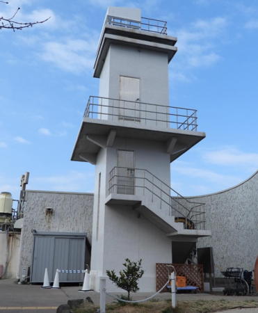
1964. Active; focal plane 59 m (194 ft); two white flashes every 8 s. 12 m (39 ft) square cylindrical concrete tower with double gallery, adjacent to a 1-story museum building. Entire lighthouse is white. Yukihiro Matsumura's photo is at right, Trabas has a photo, Lighthouse-Japan.com has a page with several photos, FOAL's page has good photos, and Google has a satellite view and a street view from the neighboring Kōbe-Awaji-Naruto Expressway. The adjoining building is a restaurant with a small museum devoted to Naruto Strait and its whirlpools. Located near the tip of a very sharp promontory overlooking the northern end of the Ōnaruto Bridge, which crosses the Naruto Strait and joins Awaji to Shikoku. Accessible by a scenic drive that winds to the tip of the promontory. Site open and visitors can climb the external stairway to an observation level halfway up the tower. . ARLHS JPN-650; JCG-3458; Admiralty M5811.4; NGA 7172.
* Minato Kō West Breakwater
1976. Active; focal plane 12 m (39 ft); two red flashes every 7 s. 9.5 m (31 ft) round cylindrical concrete tower. Entire lighthouse is red. FOAL has a photo, Trabas has a closeup photo, and Google has a street view and a satellite view. Located at the end of the west breakwater of Minato, a small port on the southwest coast of Awaji Shima. Accessible by walking the pier. Site open, tower closed. ARLHS JPN-1782; JCG-3966; Admiralty M5809; NGA 7980.
* Minato Kō East Breakwater (2?)
Date unknown (station established 1930). Active; focal plane 11 m (36 ft); two green flashes every 7 s. 9.5 m (31 ft) round concrete tower, flared at the top, attached to a small equipment shelter. Entire lighthouse is white. FOAL has a photo, Trabas has a closeup photo, S. Katsuragi has a 2023 photo, and Google has a street view and a satellite view. Located at the end of the east breakwater of Minato. Accessible by walking the pier. Site open, tower closed. ARLHS JPN-1781; JCG-3965; Admiralty M5809.2; NGA 7976.

To Saki Light, Minamiawaji, July 2020
Instagram photo by Yukihiro Matsumura

Information available on lost lighthouses:

Notable faux lighthouses:

Adjoining pages: North: Kōbe and Akashi | South: Tokushima

Return to the Lighthouse Directory index | Ratings key

Posted December 22, 2006. Checked and revised September 26, 2023. Lighthouses: 26. Site copyright 2023 Russ Rowlett and the University of North Carolina at Chapel Hill.