Lighthouses of Japan: Okayama

The nation of Japan, known in Japanese as Nihon or Nippon (日本), occupies an archipelago off the east coast of Asia. The four main islands are Hokkaidō in the north, Honshū (the largest) in the center, Shikoku in the south, and Kyūshū in the southwest. The country includes thousands of other islands of all sizes; among them the Ryūkyū (Nansei) Islands are a long chain extending to the southwest and including the large island of Okinawa, and the Nanpō Islands are another long chain extending south into the Pacific Ocean. Much of Japan is mountainous but the coastal regions are densely populated and urbanized; the country's population is about 126 million.

Japan is divided into 47 prefectures. This page lists lighthouses of the prefecture of Okayama, located near the southwestern end of the main island of Honshū west of Kōbe. Okayama faces south on the Seto Inland Sea (Seto Naikai), a network of sounds and channels separating Honshū from Shikoku.

In Japanese the word for a lighthouse is tōdai or toudai (灯台). The words saki and misaki are for capes and headlands, hana ("nose") is a promontory, hantō is a peninsula, shima (also spelled sima or jima) is an island, bae is a reef, iwa or shi is a rocky reef, amase or se is a shoal, wan is a bay, nada is a sound or basin, kaikyō is a strait, kawa is a river, and or minato is a harbor.

Lighthouses in Japan are operated and maintained by the Japanese Coast Guard's Maritime Safety Agency. On Honshū there is at least one Coast Guard Section Office in each prefecture, often two or more. Okayama has two offices, at Tamano and Mizushima (Kurashiki).

ARLHS numbers are from the ARLHS World List of Lights. JCG numbers are the Japanese Coast Guard's light list numbers. Admiralty numbers are from volume M of the Admiralty List of Lights & Fog Signals. U.S. NGA List numbers are from Publication 112.

General Sources
Lighthouses in Japan - Okayama
This site covers major lighthouses throughout the country.
Lighthouse-Japan.com - Okayama
A large site with photos and notes from recent visits.
Form of a Lighthouse - Okayama
A large and growing web site based on recent visits; cited below as FOAL.
Tamano Coast Guard Beacons
Information and photos for all the lights of the Tamano Coast Guard District.
Lighthouses in Okayama Prefecture
Photos by various photographers available from Wikimedia.
Online List of Lights - Japan
Photos by Alexander Trabas.
Japan: Modern Lighthouses
Historic postcard views posted by Michel Forand.
Navionics Charts
Navigation chart for the Inland Sea.


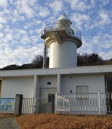
Mu Shima Light, Kasaoka, February 2022
Wikimedia Creative Commons photo by Barsaka2
Tamano Coast Guard District Lighthouses

Bizen City Lighthouses
Unoisi Hana
1964. Active; focal plane 24 m (79 ft); three white flashes every 14 s. 8.5 m (28 ft) round cylindrical concrete white tower. Trabas has a photo, FOAL has a view from the sea (bottom of the page), another view from the sea and a 2021 drone view are available, and Google has a satellite view. Located on a promontory at the southeastern tip of Kakui Shima, an island just off the coast south of Bizen. Site status unknown. ARLHS JPN-716; JCG-3899; Admiralty M5755.3; NGA 7816.
Hinase Kō
1961. Active; focal plane 12 m (39 ft); red flash every 3 s. 8.5 m (28 ft) concrete post rising from a square 1-story concrete equipment room. Entire lighthouse is red. Trabas has a closeup photo, the Coast Guard has a page for the lighthouse, FOAL's page has photos, and Google has a sea view and a satellite view. Located at the end of a detached breakwater protecting the entrance to Hinase harbor in Bizen. Accessible only by boat. Site open, tower closed. ARLHS JPN-1883; JCG-3900; Admiralty M5755; NGA 7820.
Ōtsabu (Ōtabu) Shima
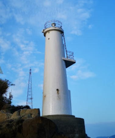
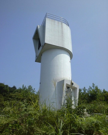
1994. Active; focal plane 31 m (102 ft); white light, 3 s on, 3 s off. 11 m (36 ft) white concrete tower with gallery. The tower also has a spotlight (JCG-3901.2, Admiralty M5754.8) illuminating a nearby shoal. A Coast Guard photo is at right, Lighthouse-Japan.com has good photos, FOAL's page has photos, Gothloli Miku has a 2018 closeup, a 2023 closeup is available, Trabas has a distant view, and Google has a satellite view. Located on a small island in the northwest corner of Harima Bay about 10 km (6 mi) southwest of Ako. Accessible only by boat. Site status unknown. ARLHS JPN-467; JCG-3901.1; Admiralty M5754.85; NGA 7826.
Takagono Sho (Syo)
1960. Active; focal plane 11 m (36 ft); two white flashes every 5 s. 11 m (36 ft) concrete post rising from one end of an elliptical 1-story concrete equipment shelter. Lighthouse painted black with one red horizontal band. Trabas has a good photo, the Coast Guard has a page for the lighthouse, and Google has a satellite view. Located on a dangerous rock in Bizen harbor. Accessible only by boat. Site open, tower closed. JCG-3913; Admiralty M5754; NGA 7828.

Setouchi City Lighthouses
Kamiikada (Kami Ikada)
1950. Active; focal plane 10 m (33 ft); one short and one long green flash every 8 s. 8 m (26 ft) round cylindrical concrete tower mounted on a large concrete pier. Entire lighthouse is green. Trabas has a photo, a distant 2022 view is available, and Google has a satellite view. Located on the seaward side of a reef about 4 km (2.5 mi) northeast of Ushimado. Accessible only by boat. Site open, tower closed. JCG-3916; Admiralty M5752.4; NGA 7840.
Ōtsabu Shima Light
Ōtsabu Shima Light, Bizen
Japanese Coast Guard Tamano Office photo
Ki Shima (Bizen Ki Shima, Kishima)
1971. Active; focal plane 17 m (56 ft); white flash every 4 s. 12 m (39 ft) round cylindrical white concrete tower, rising through a square platform. Kenichiro Asai has a 2023 photo and Google has a satellite view. Located on the southeast tip of O Shima, a small island about 3 km (2 mi) southeast of Ushimado. Accessible only by boat. Site status unknown. ARLHS JPN-1886; JCG-3917; Admiralty M5752.2; NGA 7844.
* Ushimado Kō
1971. Active; focal plane 13 m (43 ft); continuous white light with a more intense flash every 3 s. 11 m (36 ft) round white concrete tower with a small gallery. FOAL's page has photos (top half of the page), Trabas has a closeup, the Coast Guard's page has a good photo, Adam Stuart has a fuzzy photo, Kunio Muraoka has a 2021 drone view, and Google has a satellite view and a distant street view. Located on a rocky point on the northwest side of Maejima, the island sheltering the harbor of Ushimado, about 1 km (0.6 mi) east of the town's waterfront. Site open, tower closed. ARLHS JPN-1903; JCG-3918; Admiralty M5751.8; NGA 7848.
* Ushimado
Date unknown. Inactive. Approx. 12 m (39 ft) square traditional wood tower with a pyramidal roof, mounted on a square stone pedestal. FOAL's page has photos (near the bottom of the page) and Google has a street view and a satellite view. A well-preserved historic lighthouse. Located on the waterfront at the entrance to Ushimado harbor. Site open, tower closed.
#Ushimado Kō Breakwater (1)
1950. Replaced. This was a 12 m (39 ft) white concrete post rising from a square 1-story concrete equipment room. Yuko Honda has a sunset photo, Lighthouse-Japan has a page with a photo, FOAL's page has photos (middle of the page), Trabas has a closeup, and Reinhard & Ulrike Berns have a photo in which the light is seen in the upper left corner. The lighthouse has been replaced by a light (focal plane 12 m (39 ft); green flash every 3 s) on an 8 m (26 ft) white post; Google has a street view and a satellite view of the new light. Located at the end of a detached breakwater at Ushimado, a small and very scenic port about 25 km (15 mi) east southeast of Okayama. Accessible only by boat. Site open, tower closed. ARLHS JPN-1904. Active light: JCG-3919; Admiralty M5752; NGA 7852.
Yomogi Saki (Yomogisaki)
1962. Active; focal plane 10 m (33 ft); white flash every 5 s. 8 m (26 ft) round cylindrical concrete tower with double gallery, mounted on a square concrete pier. Entire lighthouse is white. The Coast Guard has a page with a closeup photo, Trabas has a closeup photo, FOAL's page has good photos, and Google has a satellite view. Located at the foot of a promontory about 4 km (2.5 mi) southwest of Ushimado. The author of Lighthouse-Japan.com reached the lighthouse on foot but found the going difficult. Site open, tower closed. ARLHS JPN-1905; JCG-3921; Admiralty M5751.6; NGA 7856.

1950 Ushimado Kō Breakwater Light, Ushimado, April 2010
Flickr Creative Commons photo by Yuko Honda

Okayama City Lighthouses
Inu Shima Shiraishi (Inujima Siroisi)
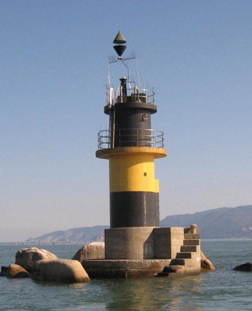
1964. Active; focal plane 10 m (33 ft); three quick white flashes every 10 s. 10 m (33 ft) round cylindrical concrete tower mounted on a concrete pier. Lighthouse painted black with one yellow horizontal band. The photo from the Coast Guard's page is at right, a closeup 2019 photo is available, FOAL has distant views (3/4 the way down the page), Trabas also has a distant view, and Google has a satellite view. Inu Shima is a small, inhabited island about 6 km (4 mi) southeast of the entrance to Okayama harbor. Located on a reef off the east coast of Inu Shima. Accessible only by boat. Site open, tower closed. JCG-4008; Admiralty M5751.4; NGA 8036.
* Saidaiji (Saidaizi) Kō
1943. Active; focal plane 13 m (43 ft); red light, 3 s on, 3 s off. 9.5 m (31 ft) round cylindrical concrete tower. Entire lighthouse is red. Trabas has a closeup photo, FOAL has photos (fifth row on the page), and Google has a street view and a satellite view. Located at the end of the east breakwater of a small boat harbor in Okayama. Accessible by walking the pier. Site open, tower closed. JCG-4011; Admiralty M5749; NGA 8048.
Tsubushisho (Tubusi Syo)
1958. Active; focal plane 11 m (36 ft); two red flashes, one short and one long, every 8 s. 11 m (36 ft) round concrete tower with gallery, mounted on a round concrete pier. Tower painted red. The Coast Guard's page has a closeup photo, FOAL has photos (third and fourth row on the page), Trabas has a closeup, Tomohiro Okada has a 2023 photo, and Google has a satellite view and a distant street view. Located on a shoal in Okayama harbor. Accessible only by boat. Site and tower closed. JCG-4012; Admiralty M5751; NGA 8052.
Kome Saki (Komesaki)
1966. Active; focal plane 25 m (82 ft); white light, 3 s on, 3 s off. 10 m (30 ft) round white concrete tower rising from a 1-story equipment building. FOAL has two photos (halfway down the page), Trabas has a photo, the Coast Guard's page has a photo, a 2023 closeup is available, and Google has a satellite view. Located on the promontory on the west side of the entrance to the well-protected harbor of Okayama. Site status unknown. Site open, tower closed. ARLHS JPN-284; JCG-4009; Admiralty M5748.6; NGA 8040.

Tamano City Lighthouses
Ohiru Shima
1938. Active; focal plane 35 m (115 ft); white flash every 5 s. 14 m (46 ft) 2-stage round concrete tower with gallery. The lower stage appears to be a 5 m (16 ft) round concrete lighthouse; the lantern was removed and replaced with a 9 m (30 ft) round cylindrical stage. Entire lighthouse is white. Trabas has a photo, Kenichiro Asai has a 2022 view from the sea, and Google has a satellite view. Located on a small island in a narrow passage about 16 km (10 mi) south of Okayama. Accessible only by boat. Site and tower closed. JCG-4026; Admiralty M5748; NGA 8070.
Inujima Shima Light
Inu Shima Shiraishi Light, Okayama
Japanese Coast Guard Tamano Office photo
Uno Kō
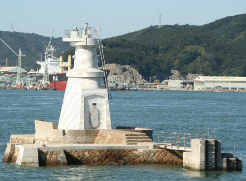
1911. Active; focal plane 11 m (36 ft); white flash every 3 s. 9 m (30 ft) round strongly conical tower, painted white and mounted on a rectangular concrete pier. There is an equipment closet in the base, but access to the light is by an external ladder. The photo from the Coast Guard page at right, FOAL has a closeup photo (bottom of the page), Trabas also has a closeup, Kenichiro Asai has a 2022 photo, and Google has a sea view and a satellite view. This small lighthouse is a rare example of an early Japanese harbor light. Located on a shoal in Uno harbor in Tamano, off the northeast coast of Naoshima. Accessible only by boat. Site and tower closed. ARLHS JPN-2481; JCG-4037; Admiralty M5740; NGA 8082.
Inumodori Hana (2?)
Date unknown (station established 1927). Active; focal plane 13 m (43 ft); one long and two short green flashes every 13 s. 13 m (43 ft) concrete post centered on a square 1-story equipment shelter, all mounted on a round stone pier. Entire lighthouse is green. Trabas has a closeup photo, the Coast Guard page has a good photo, Kenichiro Asai has a 2023 photo, and Google has a sea view and a satellite view. It seems likely that the stone pier originally carried a smaller light. Located about 30 m (100 ft) off a promontory between the Uno and Hibi harbors of Tamano. Accessible only by boat. Site and tower closed. JCG-4045; Admiralty M5738; NGA 8098.
* Hibi Kō East Breakwater
1971. Active; focal plane 13 m (43 ft); red flash every 3 s. 9.5 m (31 ft) concrete post rising from a square 1-story concrete equipment room. Entire lighthouse is red. FOAL's page has photos, Trabas has a closeup, the Coast Guard has a page for the lighthouse, and Google has a satellite view. Located at the end of the east breakwater of Hibi harbor in Tamano. Accessible by walking the pier. Site open, tower closed. ARLHS JPN-1881; JCG-4046; Admiralty M5737.7; NGA 8102.
 

Uno Kō Light, Tamano
Japanese Coast Guard Tamano Office photo

Mizushima Coast Guard District Lighthouses

Kurashiki City Lighthouses
* Kotoura Kō East Breakwater
1954. Active; focal plane 11 m (36 ft); red light, 3 s on, 3 s off. 9 m (30 ft) concrete post rising from a square 1-story concrete equipment room. Entire lighthouse is red. FOAL's page has photos, Trabas has a closeup, and Google has a street view and a satellite view. Located at the end of the east breakwater of Kotoura harbor in Kurashiki. Accessible by walking the pier. Site open, tower closed. ARLHS JPN-1889; JCG-4053; Admiralty M5737.5; NGA 8110.
Kusumi (Kusume) Hana
1942. Active; focal plane 12 m (39 ft); one short and one long green flash every 11 s. 11 m (36 ft) round concrete tower, flared at the top, with gallery. Entire lighthouse painted green. Kenichiro Asai's 2023 photo is at right, FOAL's page has photos, Trabas has a closeup, additional photos are available, and Google has a satellite view. Seen in the background of the several of the photos is the Shimotsui-Seto Bridge, the northernmost in a chain of six bridges on the Seto-Chuo Expressway connecting Honshū and Shikoku. The lighthouse is located just off the end of a sharp promonotory about 1.6 km (1 mi) east of the north end of the bridge. Site status unknown. ARLHS JPN-317; JCG-4056; Admiralty M5737; NGA 8114.
#Shimotsui Kō (1)
Date unknown. Active; focal plane 10 m (33 ft); continuous red light with two more intense flashes every 8 s. This was an 8.5 m (28 ft) round concrete tower with gallery, attached to a square 1-story equipment room. Lighthouse painted red. Yoshizumi Endo has a 2009 photo. This light was replaced in March 2016 with a simple red post. FOAL's page has April 2017 photos of the new light, Trabas also has a photo, and Google has a satellite view. Located at the end of the breakwater mole at Shimotsui, a short distance west of the north end of the Shimotsui-Seto Bridge. Site and tower closed. ARLHS JPN-1899; JCG-4058; Admiralty M5735; NGA 8118.
Mizushima Kō West Breakwater
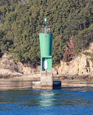
Date unknown. Active; focal plane 13 m (43 ft); two green flashes every 5 s. 10 m (33 ft) round hourglass-shaped concrete tower attached to a small equipment shelter. Entire lighthouse is white. Trabas has a photo, Kenichiro Asai has a photo, and Google has a satellite view. Located on a breakwater on the west side of the main entrance to Mizushima harbor. Site status unknown. JCG-4275; Admiralty M5733; NGA 8272.
Tamashima (Tamasima) Outer Breakwater
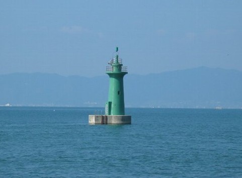
1993. Active; focal plane 12 m (39 ft); green flash every 3 s. 9 m (30 ft) round concrete tower, flared at the top, attached to a small equipment shelter. Entire lighthouse is white. Trabas has a closeup photo, FOAL has a photo (fourth row, right), Kenichiro Asai has a photo, and Google has a satellite view and a distant street view. Located at the southeast end of a detached breakwater at Mizushima. Accessible only by boat. Site status unknown. ARLHS JPN-1901; JCG-4288; Admiralty M5732.3; NGA 8280.

Kusumi Hana Light, Kurashiki, February 2023
Google Maps photo by Kenichiro Asai

Kasaoka City (Kasaoka Islands) Lighthouses
The city of Kasaoka includes a chain of islands, known as the Kasaoka Islands, stretching south southeast across the Inland Sea.
Hyaken (Hyakken)
Date unknown. Active; focal plane 13m (43 ft); one short and one long green flash every 8 s. 10 m (33 ft) round concrete tower with gallery, mounted on a round concrete pier. Entire lighthouse painted green. A Coast Guard photo is at right, Kenichiro Asai has a 2023 photo, Trabas has a distant view, and Google has a satellite view and a distant sea view. Not to be confused with the Hyaken Shima Light in Hiroshima Prefecture, this is one of several lights guiding ships through a particularly difficult and narrow passage in the Inland Sea. Located about 400 m (1/4 mi) northwest of the Shiraishi light. Accessible only by boat. Site and tower closed. JCG-4293; Admiralty M5731.9; NGA 8304.
Shiraishi (Okinosiraisi)
1938. Active; focal plane 15 m (49 ft); white flash every 3 s. 15 m (49 ft) psot rising from a 1-story equipment shelter. Entire lighthouse is white. Kenichiro Asai has a photo and a distant view and Google has a satellite view and a closeup street view. This is one of several lights guiding ships through a particularly difficult and narrow passage between the islands of Taka Shima and Shiraishi Shima. The post was added in 2017 to raise the height of the light. Located on a skerry obstructing the narrow channel, about 8 km (5 mi) south of Kasaoka. Accessible only by boat. Site and tower closed. ARLHS JPN-1896; JCG-4292; Admiralty M5732; NGA 8300.
* Shiraisishima Kō
Date unknown. Active; focal plane 12 m (39 ft); continuous red light with a more intense flash every 5 s. 8.5 m (28 ft) concrete post rising from a square 1-story concrete equipment room. Entire lighthouse is red. A photo is available and Google has a satellite view and a closeup sea view. Located at the end of the main breakwater of Shiraisi Shima. Accessible by walking the pier. Site open, tower closed. ARLHS JPN-1900; JCG-4291; Admiralty M5732.02; NGA 8296.

Hyaken Light, Kasaoka
Japanese Coast Guard photo
* Manabeshima Kō
1982. Active; focal plane 13 m (43 ft); continuous red light with a more intense flash every 6 s. 9.5 m (31 ft) concrete post rising from a square 1-story concrete equipment room. Entire lighthouse is red. Google has a sea view and a satellite view. Located at the end of the main breakwater of Manabe Shima. Accessible by walking the pier. Site open, tower closed. ARLHS JPN-1890; JCG-4289; Admiralty M5732.15; NGA 8284.
Mu Shima (Mushima)
1922. Active; focal plane 70 m (230 ft); white light, 3 s on, 3 s off. 13 m (43 ft) round cylindrical concrete tower with lantern and gallery, rising from a 1-story concrete keeper's house. Entire lighthouse is white. A 2022 photo appears at the top of this page, Lighthouse-Japan.com has a page with good photos, a 2012 closeup photo is available, Trabas has a photo, Kazuhiro Okano has a closeup, and Google has a satellite view. This lighthouse stands at the eastern entrance to Hiiuchi Bay, one of the wider sections of the Inland Sea. Located on an island about 6 km (3.5 mi) northwest of Hako Saki on Shikoku. Accessible only by boat. Site status unknown. . ARLHS JPN-375; JCG-4401; Admiralty M5500; NGA 8380.

Information available on lost lighthouses:

Notable faux lighthouses:

Adjoining pages: East: Himeji Area | South: Kagawa | West: Onomichi Area

Return to the Lighthouse Directory index | Ratings key

Posted January 25, 2007. Checked and revised October 12, 2023. Lighthouses: 28. Site copyright 2023 Russ Rowlett and the University of North Carolina at Chapel Hill.