Lighthouses of Japan: Himeji Area

The nation of Japan, known in Japanese as Nihon or Nippon (日本), occupies an archipelago off the east coast of Asia. The four main islands are Hokkaidō in the north, Honshū (the largest) in the center, Shikoku in the south, and Kyūshū in the southwest. The country includes thousands of other islands of all sizes; among them the Ryūkyū (Nansei) Islands are a long chain extending to the southwest and including the large island of Okinawa, and the Nanpō Islands are another long chain extending south into the Pacific Ocean. Much of Japan is mountainous but the coastal regions are densely populated and urbanized; the country's population is about 126 million.

Japan is divided into 47 prefectures. This page includes lighthouses of the southwestern coast of the Japanese prefecture of Hyōgo, including the Himeji metropolitan area and the Ieshima Islands. This area was in the former province of Harima.

Southern Hyōgo faces south on the eastern end of the Seto Inland Sea (Seto Naikai), which separates Honshū from Shikoku. Hyōgo also includes the large island of Awaji, which nearly spans the Seto Inland Sea and comes very close to connecting Honshū and Shikoku. Lighthouses of the Kōbe Area and Awaji Shima are on separate pages. In addition, Hyōgo Prefecture also has a northern coast facing the Sea of Japan. Lighthouses of that coast are described on the Tottori Area page.

In Japanese the word for a lighthouse is tōdai or toudai (灯台). The words saki and misaki are for capes and headlands, hana ("nose") is a promontory, hantō is a peninsula, shima (also spelled sima or jima) is an island, bae is a reef, iwa or shi is a rocky reef, amase or se is a shoal, wan is a bay, nada is a sound or basin, kaikyō is a strait, kawa is a river, and or minato is a harbor.

Lighthouses in Japan are operated and maintained by the Japanese Coast Guard's Maritime Safety Agency. On Honshū there is at least one Coast Guard Section Office in each prefecture, often two. The lighthouses on this page are maintained by the Himeji office.

ARLHS numbers are from the ARLHS World List of Lights. JCG numbers are the Japanese Coast Guard's light list numbers. Admiralty numbers are from volume M of the Admiralty List of Lights & Fog Signals. U.S. NGA List numbers are from Publication 112.

General Sources
Lighthouses in Japan - Hyōgo
A comprehensive site covering the major lighthouses of Japan.
Lighthouse-Japan.com - Hyōgo
A large site with photos and notes from recent visits.
Form of a Lighthouse - Hyōgo
Another large web site with recent photos, cited below as FOAL.
Misty's Japanese Lighthouse Tour - Hyōgo
Photos and a few notes for lighthouses in all parts of the country.
Main Beacons of Himeji Coast Guard Jurisdiction
This page has small photos of lights maintained by the Himeji Coast Guard office.
Online List of Lights - Japan
Photos by Alexander Trabas.
Lighthouses in Hyōgo Prefecture
Photos by various photographers available from Wikimedia.
Navionics Charts
Navigation chart for Hyōgo.


Akō Misaki Light, Akō, January 2010
Wikimedia Creative Commons photo by 663highland
Harima Town Lighthouses
#Beppu East Harbor West Breakwater
Date unknown. Inactive since 2008 and since demolished. This was an 8.5 m (28 ft) round white concrete tower. No photo available and the tower is not seen in Google's satellite view of the location. What was once a breakwater is now the east edge of Higashiniijima, a large area filled for industrial development. Located at the southeastern corner of Higashiniijima. Site open, tower closed. ex-JCG-3840; ex-Admiralty M5776; ex-NGA 7688.
Beppu (Befu, Higashi-Harima) Kō East Breakwater
Date unknown. Active; focal plane 17 m (56 ft); red light, 2 s on, 2 s off. 16 m (52 ft) round cylindrical concrete tower with lantern and gallery. Entire lighthouse is red. Trabas has a photo, Shuppo Oyamano has a closeup photo showing a tall ship passing the lighthouse, FOAL has a distant view (last row left), and Google has a satellite view. Located at the end of the east breakwater of the main harbor of Harima. Site open, tower closed. JCG-3838; Admiralty M5774.4; NGA 7680.

Kakogawa City Lighthouses
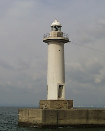
Beppu (Befu, Higashi-Harima) Kō West Breakwater
Date unknown. Active; focal plane 17 m (56 ft); green light, 2 s on, 2 s off. 16 m (52 ft) round cylindrical concrete tower with lantern and gallery. Entire lighthouse is white. A Coast Guard photo is at right, Miko Coffey has a photo, Trabas has a photo, Teruyuki Noma has a photo, FOAL has a distant view (last row right), and Google has a satellite view. Located at the end of the west breakwater of the main harbor of Harima. Site and tower closed. ARLHS JPN-1880; JCG-3839; Admiralty M5774; NGA 7684.
Beppu West Port (Nisiko) Breakwater
Date unknown. Active; focal plane 11 m (36 ft); two green flashes every 7 s. 8.5 m (28 ft) round hourglass-shaped concrete tower. Entire lighthouse is white. Trabas has a photo, the Coast Guard has a fuzzy photo, and Google has a satellite view. Located at the end of a very long breakwater at the west end of Harima. Accessible only by boat. Site open, tower closed. JCG-3845; Admiralty M5773; NGA 7700.

Takasago City Lighthouses
Takasago East Breakwater
Date unknown. Active; focal plane 13 m (43 ft); two red flashes every 6 s. 10 m (33 ft) 10 m (33 ft) concrete post attached to a square 1-story concrete equipment room. Entire lighthouse is red. Trabas has a photo, FOAL has a photo (bottom row left), the Coast Guard has a fuzzy photo, and Google has a satellite view. Located on a detached breakwater on the east side of the entrance to Takasago harbor. Accessible only by boat. Site open, tower closed. ARLHS JPN-1538; JCG-3846; Admiralty M5772.5; NGA 7704.
Beppu West Breakwater Light
Beppu Kō West Breakwater Light, Kakogawa
Japanese Coast Guard Fifth Region photo
* Takasago West Breakwater
Date unknown. Active; focal plane 13 m (43 ft); green light, 6 s on, 2 s off. 10 m (33 ft) 10 m (33 ft) concrete post attached to a square 1-story concrete equipment room. Entire lighthouse is white. Trabas has a closeup photo, FOAL has a photo (bottom row right), and Google has a satellite view. Located on the breakwater on the west side of the entrance to Takasago harbor. Accessible by walking the pier. Site open, tower closed. ARLHS JPN-1539; JCG-3847; Admiralty M5772; NGA 7708.
Takasago Nisiko West Breakwater
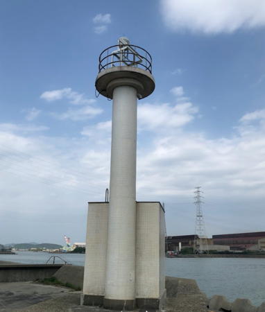
Date unknown. Active; focal plane 12 m (39 ft); green flash every 4 s. 10 m (33 ft) round hourglass-shaped white concrete tower. Trabas has a closeup photo and Google has a satellite view. This light is in an industrial area with no public access. Located at the end of a short breakwater at the west breakwater of Takasago. Site and tower closed. ARLHS JPN-1522; JCG-3849; Admiralty M5771.6; NGA 7712.
* Ibo Kō East Breakwater
Date unknown. Active; focal plane 13 m (43 ft); three red flashes every 13 s. 8.5 m (28 ft) concrete post attached to a square 1-story concrete equipment shelter. Entire lighthouse is white. Trabas has a closeup photo, FOAL has photos (bottom row on the page), and Google has a satellite view. Located on a short breakwater on the east side of the entrance to Ibo harbor in Takasago. Site open, tower closed. JCG-3851; Admiralty M5771; NGA 7720.
* Ibo Kō West Breakwater
1930. Active; focal plane 10 m (33 ft); green light, 3 s on, 3 s off. 8.5 m (28 ft) concrete post attached to a square 1-story concrete equipment shelter. Entire lighthouse is white. A photo is at right, Trabas has a closeup photo and Google has a satellite view and a distant street view. Located on the west side of the entrance to Ibo harbor in Takasago. Site open, tower closed. ARLHS JPN-1497; JCG-3850; Admiralty M5770; NGA 7716.

Himeji City: Mainland Lighthouses
Himeji is a historic city, the former capital of Harima Province, and a major port. It has a population of more than half a million.

*
Yagi Kō
Date unknown. Active; focal plane 11 m (36 ft); green light, 3 s on, 3 s off. 8.5 m (28 ft) concrete post attached to a square 1-story concrete equipment shelter. Entire lighthouse is white. Trabas has a closeup photo and Google has a satellite view. Located at the end of a breakwater in the Yagi ward of Himeji. Site open, tower closed. ARLHS JPN-1546; JCG-3852; Admiralty M5769; NGA 7724.
 

Ibo Kō West Breakwater Light, Takasago, April 2021
Google Maps photo by myrmno
* Mega (Himeji) Gyoko
Date unknown. Active; focal plane 13 m (43 ft); red light, 2 s on, 2 s off. 10 m (33 ft) concrete post attached to a square 1-story concrete equipment shelter. Entire lighthouse is red. Trabas has a photo and Google has a satellite view and a closeup street view. Located at the end of the east (main) breakwater of a small boat harbor on the east side of Himeji. Accessible by walking the pier. Site open, tower closed. ARLHS JPN-1514; JCG-3853.3; Admiralty M5767; NGA 7726.
* Himeji (Mega) Kō East Outer Breakwater
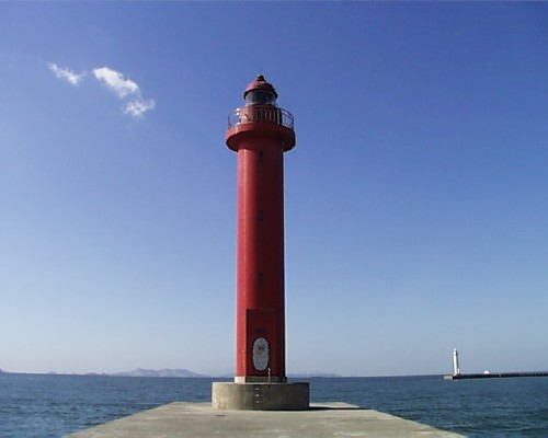
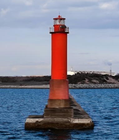
Date unknown. Active; focal plane 20 m (66 ft); red flash every 4 s. 19 m (62 ft) round cylindrical concrete tower with lantern and gallery. Entire lighthouse is red. The Coast Guard's photo appears at right, Trabas has a photo, FOAL has photos (second and sixth rows, right), and Google has a satellite view. Himeji is a major port area about 10 km (6 mi) west of Kakogawa. Mega Kō is the eastern basin of the harbor complex. Located at the end of a short mole on the east side of the entrance to Mega Kō. Accessible by walking the pier. Site open, tower closed. ARLHS JPN-1515; JCG-3856; Admiralty M5766.3; NGA 7728.
Himeji (Mega) Kō West Outer Breakwater
Date unknown. Active; focal plane 20 m (66 ft); green flash every 3 s. 19 m (62 ft) round cylindrical concrete tower with lantern and gallery. Entire lighthouse is white. Trabas has a photo, FOAL has photos (third and seventh rows, left), the lighthouse can be seen in the right background of the photo of the East Breakwater Light at right, and Google has a satellite view. Located at the southeast end of a detached breakwater. Accessible only by boat. Site and tower closed. JCG-3858; Admiralty M5766.5; NGA 7736.
Himeji (Mega) Kō West Breakwater
Date unknown. Active; focal plane 17 m (56 ft); green flash every 3 s. 16 m (52 ft) round concrete tower. Entire lighthouse is white. Trabas has a photo, FOAL has photos (second and sixth rows, left), and Google has a satellite view. Located at the end of the older west breakwater of Himeji Kō. Site and tower closed. JCG-3857; Admiralty M5766; NGA 7732.
Himeji Ko East Breakwater Light
Himeji (Mega) Kō East Outer Breakwater Light, Himeji
Japanese Coast Guard Fifth Region photo
* Himeji (Mega) Kō (1) (relocated)
1937. Inactive since 1966. 7.5 m (25 ft) round unpainted concrete tower, rising from a square base. Google has a street view and a satellite view. This small light formerly stood at the Himeji harbor entrance; in 1993 it was restored and relocated to a waterfront park just west of the Ieshima and Shodoshima ferry terminal. Site open, tower closed.
Shikama (Sikama) Kō East Breakwater
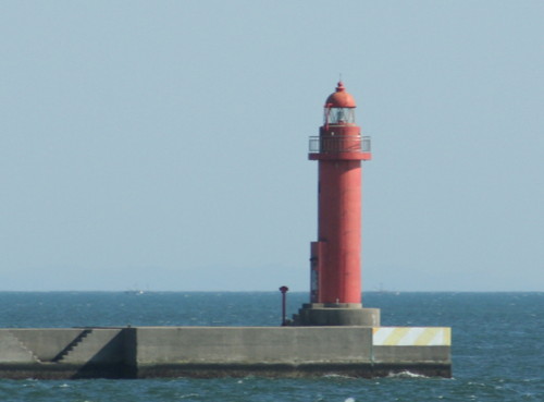
Date unknown. Active; focal plane 15 m (49 ft); two red flashes every 6 s. 14 m (46 ft) round concrete tower with lantern and gallery, painted red. Wikimedia has the photo at right and another photo, Trabas has a photo, FOAL has several photos (near the bottom of the page), a 2023 view from the sea is available, and Google has a satellite view. Shikama Kō is the central basin of the Himeji port complex. Located at the end of the east mole at the entrance to Sikama Kō. Site and tower closed. ARLHS JPN-1535; JCG-3861; Admiralty M5764.6; NGA 7740.
Shikama (Sikama) Kō East Breakwater No. 2
Date unknown. Active; focal plane 13 m (43 ft); red flash every 3 s. 10 m (33 ft) concrete post attached to a square 1-story concrete equipment shelter. Entire lighthouse is red. Trabas has a closeup photo, FOAL has a photo (bottom of the page), a 2021 view from the sea is available, and Google has a street view and a satellite view. Located at the end of the original (now inner) east breakwater at Sikama Kō. Site and tower closed. ARLHS JPN-1534; JCG-3863; Admiralty M5764; NGA 7748.
Shikama (Sikama) Kō West Breakwater
Date unknown. Active; focal plane 15 m (49 ft); two green flashes every 6 s. 14 m (46 ft) round concrete tower with lantern and gallery, painted white. Trabas has a photo, FOAL has several photos (near the bottom of the page), and Google has a satellite view. Located at the end of the east mole at the entrance to Sikama Kō. Site and tower closed. ARLHS JPN-1536; JCG-3862; Admiralty M5764.8; NGA 7744.
Shikama East Breakwater Light
Shikama East Breakwater Light, Himeji, May 2009
Wikimedia Creative Commons photo by Corpse Reviver
Hirohata Kō (East Breakwater)
Date unknown. Active; focal plane 17 m (56 ft); red light, 2 s on, 2 s off. 17 m (56 ft) round concrete tower with lantern and gallery, painted red. Kenichiro Asai's 2023 photo is at right, Trabas has a photo, FOAL has a photo (third row from the bottom of the page), and Google has a satellite view. Hirohata Kō is a basin on the west side of the Himeji port complex. The area is heavily industrial, centering on a large Nippon Steel plant. Located at the end of the east mole at the entrance to Hirohata Kō. Site and tower closed. ARLHS JPN-1493; JCG-3873; Admiralty M5762; NGA 7752.
Hirohata Kō Range Front
Date unknown. Active; focal plane 30 m (98 ft); continuous red light. 28 m (92 ft) square steel skeletal tower with gallery. Trabas has a photo and Google has a satellite view. Located on the waterfront at the Nippon Steel plant. Site and tower closed. ARLHS JPN-1494; JCG-3874; Admiralty M5763.5; NGA 7756.
Hirohata Kō Range Rear
Date unknown. Active; focal plane 47 m (154 ft); continuous red light. 45 m (148 ft) square steel skeletal tower with gallery. Trabas has a photo and Google has a satellite view. Located 510 m (1673 ft) due north of the front light. Site and tower closed. ARLHS JPN-1495; JCG-3875; Admiralty M5763.6; NGA 7760.
Aboshi (Abosi) Kō
Date unknown. Active; focal plane 11 m (36 ft); green flash every 4 s. 8.5 m (28 ft) round hourglass-shaped concrete tower. Entire lighthouse is white. Trabas has a closeup photo, a 2013 photo is available, and Google has a satellite view and a very distant street view. Located at the end of a guidewall on the east side of the entrance to Aboshi harbor, near the west end of the Himeji waterfront. Accessible only by boat. Site status unknown. ARLHS JPN-1478; JCG-3876; Admiralty M5761; NGA 7764.
* Naka Kawa West Breakwater
Date unknown. Active; focal plane 13 m (43 ft); green light, 3 s on, 3 s off. 10 m (33 ft) concrete post attached to a square 1-story concrete equipment shelter. Entire lighthouse is white. Trabas has a photo, FOAL has photos (bottom of the page), and Google has a street view and a satellite view. Located on a breakwater at the western edge of Himeji. Accessible by walking the pier. Site open, tower closed. JCG-3882; Admiralty M5759.6; NGA 7776.

Hirohata Kō Light, Himeji, March 2023
Google Maps photo by Kenichiro Asai

Himeji City: Ieshima Lighthouses
The Ieshima Islands are a chain of small islands, four of them inhabited, lying about 15 km (9 mi) off the north coast of Harima Bay between Himeji and Akō. The former Town of Ieshima was merged with Himeji City in 2006.

Kami Shima (Ueshima)
Date unknown. Active; focal plane 60 m (197 ft); two flashes every 8 s. 14 m (46 ft) round cylindrical concrete tower with lantern and gallery. Entire lighthouse is white. A view from the sea is available, Trabas has a very distant view, Kenichiro Asai has a 2023 view, and Google has a satellite view. Located atop a small island in Harima Bay about 10 km (6 mi) south of Himeji. Site status unknown. ARLHS JPN-787; JCG-3923; Admiralty M5768; NGA 7860.
Kurakake Shima
Date unknown. Active; focal plane 67 m (220 ft); four white flashes every 20 s. 16 m (52 ft) round cylindrical concrete tower with gallery, attached to a small 1-story square concrete equipment room. Lighthouse painted with red and white horizontal bands. A view from the sea is available, Trabas has a very distant view, Kenichiro Asai has a 2021 view from the sea, and Google has a satellite view. Kurakake Shima, the easternmost of the Ieshima Islands, is a small, uninhabited island. Located on the highest point of the island. Accessible only by boat. Site status unknown. ARLHS JPN-306; JCG-3924; Admiralty M5758.4; NGA 7864.
Tanga Shima
1959. Active; focal plane 76 m (249 ft); white flash every 6 s. 12 m (39 ft) round white concrete tower with a flared top. A closeup photo is available, and Google has a satellite view. Tanga Shima is about 1.5 km (1 mi) in diameter; a large part of the island has been removed by quarrying operations. Located on the south side of the island. Site status unknown. ARLHS JPN-626; JCG-3926; Admiralty M5758; NGA 7868.
* Osaki Hana (Ieshima)
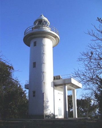
1954. Active; focal plane 70 m (230 ft); white light, 3 s on, 3 s off. 9 m (30 ft) round concrete tower with gallery, mounted on a square 1-story concrete equipment room. Entire lighthouse is white. FOAL has closeup photos (lower half of the page), Tomio Tatsumi has another photo (also seen at right), and Google has a satellite view. The lighthouse guides ships into the harbor of Ieshima, the principal town of the islands, on the north side of the island of Ieshima. Located on a promontory sheltering the west side of the approach to the harbor. Site open, tower closed. ARLHS JPN-499; JCG-3928; Admiralty M5757.6; NGA 7880.

Osaki Hana Light, Ieshima, December 2004
Google Maps photo by Tomio Tatsumi

Inge Shima
Date unknown. Active; focal plane 73 m (240 ft); two white flashes every 10 s. 11 m (36 ft) round concrete tower with gallery. Entire lighthouse is white. Yumi no Suke has a 2021 drone view, Trabas has a very distant view, and Google has a satellite view. Inge Shima is a small, uninhabited island at the western end of the Ieshima group. Located near the western end of the island. Accessible only by boat. Site status unknown. ARLHS JPN-168; JCG-3932; Admiralty M5757.3; NGA 7888.
Matsu (Matu) Shima
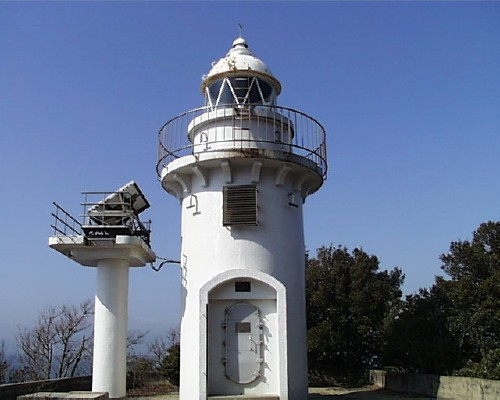
Date unknown. Active; focal plane 51 m (167 ft); white flash every 3 s. 9 m (30 ft) round cylindrical concrete tower with lantern and gallery. Entire lighthouse is white. The Coast Guard's photo is at right and Google has a satellite view. Matsu Shima is a small, uninhabited island south of the main Ieshima group, about 12 km (7.5 mi) southwest of Ieshima island. Located at the southwestern tip of the island. Site status unknown. ARLHS JPN-1513; JCG-3933; Admiralty M5757; NGA 7892.

Tatsuno City Lighthouse
* Murotsu Kō
Date unknown. Active; focal plane 11 m (36 ft); red flash every 3 s. 8.5 m (28 ft) concrete post attached to a square 1-story concrete equipment shelter. Entire lighthouse is red. Trabas has a closeup photo, a 2023 photo is available, and Google has a street view and a satellite view. Located on the east breakwater of Murotsu harbor. Accessible by walking the pier. Site open, tower closed. ARLHS JPN-1518; JCG-3885; Admiralty M5756.8; NGA 7784.

Matsu Shima Light, Ieshima
Japanese Coast Guard Fifth Region photo

Aioi City Lighthouse
Kazura Shima
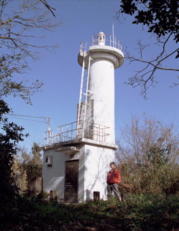
Date unknown. Active; focal plane 53 m (174 ft); three white flashes every 13 s. 13 m (43 ft) round cylindrical concrete tower with lantern and gallery, attached to a small 1-story equipment room. Entire lighthouse is white. The Coast Guard's closeup photo is at right, FOAL has a page with distant views, Takashi Mizuno has a 2019 drone view, Trabas has a photo, the Hyōgo Forest Office has a page with a photo taken during a visit to the lighthouse, and Google has a satellite view. Kazura Shima is small, rounded island in Harima Bay about 8 km (5 mi) east of the entrance to Akō harbor. The island is a forest reserve. Located on the highest point of the island. Accessible only by boat. Site status unknown. Site manager: Hyōgo Forest Management Office. ARLHS JPN-253; JCG-3886; Admiralty M5756.4; NGA 7788.

Akō City Lighthouse
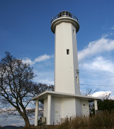
* Akō Misaki
1963. Active; focal plane 84 m (276 ft); white flash every 10 s. 16 m (52 ft) octagonal cylindrical concrete tower with lantern and gallery. Entire lighthouse is white. A photo is at the top of this page, Wikimedia has several good photos, Trabas has a closeup photo, FOAL has a good page with photos, Hiro Naka has a 2021 photo, Katsuhiko Fujita has a 2022 photo, and Google has a satellite view. This is one of the few lighthouses in the area that is accessible to the public and it commands a sweeping view of Harima Bay. However, the narrow road leading to the lighthouse does not appear to be marked so local guidence may be needed. Located on a promontory on the east side of Akō. Site open, tower closed. . ARLHS JPN-014; JCG-3889; Admiralty M5755.6; NGA 7800.
Akō
Date unknown. Active; focal plane 9 m (29 ft); six quick white flashes followed by one long white flash every 15 s. 9 m (29 ft) round cylindrical concrete tower mounted on a square pier. Upper half of the tower painted yellow, lower half black. Trabas has a photo, FOAL has a photo (halfway down the page), a 2023 photo and another photo are available, and Google has a satellite view. Located about 500 m (0.3 mi) off Akō Misaki. Accessible only by boat. Site open, tower closed. JCG-3890; Admiralty M5756; NGA 7804.
Kazura Shima Light
Kazura Shima Light, Aioi
Japanese Coast Guard Fifth Region photo

Information available on lost lighthouses:

Notable faux lighthouses:

Adjoining pages: East: Kōbe and Akashi | Southeast: Awaji Shima | West: Okayama

Return to the Lighthouse Directory index | Ratings key

Posted December 22, 2006. Checked and revised October 3, 2023. Lighthouses: 33. Site copyright 2023 Russ Rowlett and the University of North Carolina at Chapel Hill.