Lighthouses of Japan: Northern Ōita

The nation of Japan, known in Japanese as Nihon or Nippon (日本), occupies an archipelago off the east coast of Asia. The four main islands are Hokkaidō in the north, Honshū (the largest), Shikoku in the south, and Kyūshū in the southwest. The country includes thousands of other islands of all sizes; among them the Ryūkyū (Nansei) Islands are a long chain extending to the southwest and including the large island of Okinawa, and the Nanpō Islands are another long chain extending south into the Pacific Ocean. Much of Japan is mountainous but the coastal regions are densely populated and urbanized; the country's population is about 126 million.

Located at the southwestern end of the Japanese archipelago, Kyūshū is divided into seven of the prefectures. This page includes lighthouses of the northern half of Ōita Prefecture on the northeastern coast of the island. Northern Ōita faces northeast on the Seto Inland Sea, which separates Kyūshū from Honshū. It is centered on the Kunisaki Peninsula, a roughly circular bulge dominated by Mount Futago, a dormant volcano having a height of 72l m (2365 ft).

In Japanese the word for a lighthouse is tōdai or toudai (灯台). The words saki and misaki are for capes and headlands, hana ("nose") is a promontory, hantō is a peninsula, shima (also spelled sima or jima) is an island, bae is a reef, iwa or shi is a rocky reef, amase or se is a shoal, wan is a bay, nada is a sound or basin, kaikyō is a strait, kawa is a river, and or minato is a harbor.

Lighthouses in Japan are operated and maintained by the Japanese Coast Guard's Maritime Safety Agency. There is at least one Coast Guard Section Office in each prefecture, often two or more. Lighthouses in Ōita Prefecture are all maintained by the Ōita Coast Guard Office.

ARLHS numbers are from the ARLHS World List of Lights. JCG numbers are the Japanese Coast Guard's light list numbers. Admiralty numbers are from volume M of the Admiralty List of Lights & Fog Signals. U.S. NGA List numbers are from Publication 112.

General Sources
Lighthouses in Japan - Ōita
This site has photos and data for nearly all of the major lighthouses.
Lighthouse of Japan - Ōita
A comprehensive site covering the majority of the lights.
Form of a Lighthouse - Ōita
Another site with many photos of Japanese lighthouses, cited below as FOAL.
Lighthouse Visits
This site has photos for many lighthouses in this area.
Our Lighthouses in Ōita Prefecture
A comprehensive collection of photos of Ōita lighthouses.
Main Lighthouses of Ōita Prefecture
Information on the major lighthouses posted by the Ōita Coast Guard Office.
Online List of Lights - Japan
Photos by various photographers posted by Alexander Trabas.
Lighthouses in Ōita Prefecture
Photos by various photographers avilable from Wikimedia.
Navionics Charts
Navigational chart information for Ōita.
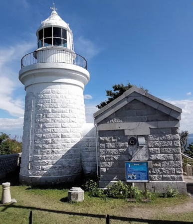

Hime Shima Light, Kunisaki, June 2022
Google Maps photo by M T
North Coast (Suō-nada) Lighthouses

This coast faces north on Suō-nada (Suō Bay), the westernmost basin of the Seto Inland Sea, southeast of the metropolitan area of Kitakyūshū.

Nakatsu City Lighthouses
Nakatsu Kō
Date unknown. Active; focal plane 12 m (39 ft); two white flashes, one short and one long, every 8 s. 9.5 m (31 ft) round concrete tower with gallery, mounted on a concrete pier. Entire lighthouse is red. Trabas has a photo and FOAL has photos (bottom of the page) but the light is not shown in Bing's satellite view. Located on a shoal off the mouth of the Yamakuni River at the western end of Nokatsu. Accessible only by boat. Site open, tower closed. JCG-5266; Admiralty M4977; NGA 9726.
Nakatsu West Breakwater
Date unknown. Active; focal plane 12 m (39 ft); one short and one long red flash every 8 s. 9.5 m (31 ft) concrete post attached to a square 1-story concrete equipment room. Entire lighthouse is red. FOAL has another page for the light, Lighthouse Visit also has a page, Trabas has a closeup photo, and Google has a satellite view. Located at the end of the detached west breakwater of Nakatsu. Accessible only by boat. Site open, tower closed. ARLHS JPN-2322; JCG-5265; Admiralty M4978; NGA 9720.
Imazu
Date unknown. Active; focal plane 14 m (46 ft); two white flashes every 5 s. 13 m (43 ft) round concrete tower attached to a small equipment shelter, mounted on a concrete pier. Lighthouse painted black with one red horizontal band. Trabas has a photo, Lighthouse Visit has a photo (bottom of the page), FOAL has a photo (second row, right), Google has a very distant street view and an indistinct satellite view. Located on a shoal off the entrance to Imazu. Accessible only by boat. Site open, tower closed. JCG-5264; Admiralty M4976.2; NGA 9716.
* Buzen Imazu Kō
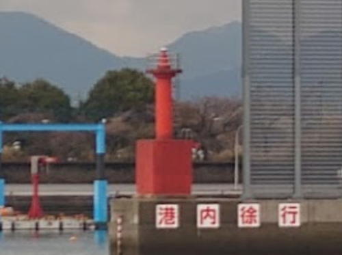
1928. Active; focal plane 12 m (39 ft); red light, 2 s on, 2 s off. 8.5 m (28 ft) concrete post attached to a square 1-story concrete equipment room. Entire lighthouse is red. A 2023 photo is at right, FOAL has another page for the light, Lighthouse Visit has photos, Trabas has a photo, a 2023 closeup is available, and Google has a street view and a satellite view. Located at the end of a pier enclosing the small boat harbor of Imazu. Accessible by walking the pier. Site open, tower closed. ARLHS JPN-2305; JCG-5263.8; Admiralty M4975.5; NGA 9714.
 

Buzen Imazu Kō Light, Nakatsu, February 2023
Google Maps photo by Quappi S.
 

Usa City Lighthouse
* Buzen Nakatsu Kō
1961. Active; focal plane 11 m (36 ft); red light, 4 s on, 4 s off. 8 m (26 ft) concrete post attached to a square 1-story concrete equipment room. Entire lighthouse is white. FOAL has another page for the light, Lighthouse Visit also has a page, Trabas has a closeup photo, a 2023 photo is available, and Google has a street view and a satellite view. ARLHS JPN-2306; JCG-5263; Admiralty M4975; NGA 9712.

Bungotakada City Lighthouses
Bungotakada (Bungo Takada)
Date unknown. Active; focal plane 11 m (36 ft); two red flashes every 8 s. 8 m (26 ft) concrete post attached to a square 1-story concrete equipment room. Entire lighthouse is red. FOAL's page for the light has photos, Trabas has a closeup photo, a 2023 photo is available, and Google has a satellite view. Located at the end of a 2.6 km (1.6 mi) long training wall along the west side of the entrance channel for the Bungo Takada harbor. Accessible only by boat. Site open, tower closed. JCG-5262; Admiralty M4974.6; NGA 9708.
#Kakazi (Kakaji) Kō North Breakwater
1964. Removed in 2015. This was an 8.5 m (28 ft) concrete post attached to a square 1-story concrete equipment room. Entire lighthouse was red. FOAL's page has photos (lower half of the page) taken in 2012, additional photos are available, and Google has a 2013 street view, but Google's satellite view confirms the removal of the light. In 2015 the breakwater was extended and the lighthouse was replaced by a post light (focal plane 11 m (36 ft); continuous red light with a more intense flash every 6 s) at the end of the extension. Lighthouse Visit has a photo of the new light (bottom of the page) and Trabas has a closeup photo. Located at the end of the north breakwater of Kakazi. Accessible by walking the pier. Site open, tower closed. ARLHS JPN-2313. New light: JCG-5261; Admiralty M4974.2; NGA 9704.
* Kakazi (Kakaji, Kak Azi, Naga Saki)
1951. Active; focal plane 24 m (79 ft); white light, 4 s on, 4 s off. 8 m (26 ft) concrete post attached to a semi-elliptical 1-story concrete equipment room. Entire lighthouse is white. Kazuhisa Mori's 2023 photo is at right, FOAL's page has photos, Lighthouse Visit has a page, several Coast Guard photos and additional photos are available, Trabas has a photo, and Google has a street view and a satellite view. Located at the tip of a long promontory sheltering the east side of the harbor of Kakazi. Accessible by road in a municipal park. Site open, tower closed. . ARLHS JPN-2312; JCG-5260; Admiralty M4974; NGA 9700.

Kakazi Light, Bungotakada, October 2023
Instagram photo by Kazuhisa Mori

Northern Kunisaki City (Taketatsu Area) Lighthouses
Biwa Saki
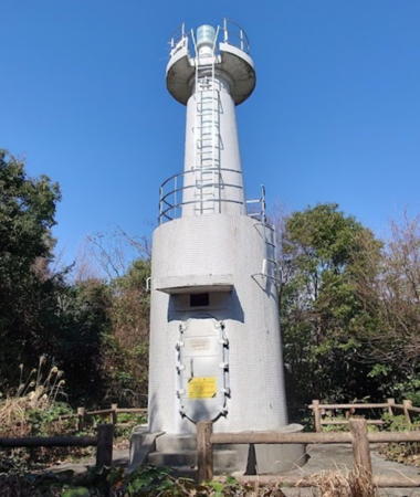
1950. Active; focal plane 50 m (164 ft); white flash every 5 s. 10 m (33 ft) round concrete tower rising from a round 1-story concrete equipment room. Entire lighthouse is white. A 2023 photo is at right, Lighthouse-Japan.com has a page with photos, FOAL's page has photos (halfway down the page), Lighthouse Visit has photos (lower half of the page), additional photos are available, Trabas has a distant view, and Google has a satellite view. Accessible by a short hike but some local guidance will be needed to locate the trail. Located on a promontory about 3 km (2 mi) east of Kakazi. Site open, tower closed. ARLHS JPN-046; JCG-5259; Admiralty M4971; NGA 9696.
* Taketatsu (Takeda, Taketazu) Kō North Breakwater
1964. Active; focal plane 12 m (39 ft); continuous red light with a more intense flash every 6 s. 8.5 m (28 ft) concrete post attached to a square 1-story concrete equipment room. Entire lighthouse is red. FOAL's page has photos, Lighthouse Visit has photos, Trabas has a closeup photo, additional photos, a 2023 closeup, and a view from the sea are available, and Google has a satellite view. This port is the terminal for ferries crossing the Seto Inland Sea to Tokuyama in Yamaguchi Prefecture, Honshū. Located at the end of the main breakwater of Taketatsu. Accessible by walking the pier. Site open, tower closed. ARLHS JPN-2336; JCG-5258; Admiralty M4972; NGA 9692.
Tarō Iwa
1970. Active; focal plane 42 m (138 ft); continuous white light. 7 m (23 ft) round hourglass-shaped concrete tower with a large round concrete lantern. Entire lighthouse is white. This lighthouse shines a beam directly on a reef vessels must avoid. Trabas has a closeup photo, FOAL's page has photos, Lighthouse Visit has photos, additional photos are available, and Google has a satellite view. Located on a promontory at Taneda, on the east side of the entrance to Taketatsu. Accessible by a short hike but some local guidance will be needed. Site open, tower closed. JCG-5257; Admiralty M4971.4.
* Imi Kō North Breakwater
1964. Active; focal plane 13 m (43 ft); continuous red light with a more intense flash every 5 s. 8.5 m (28 ft) concrete post attached to a square 1-story concrete equipment room. Entire lighthouse is red. FOAL's page has photos, Lighthouse Visit also has a page, additional photos and a 2023 closeup are available, Trabas has a closeup, and Google has a distant street view and a satellite view of the breakwater. Located at the end of the north breakwater of Imi, the terminal for ferries to Hime Shima. Accessible by walking the pier. Site open, tower closed. ARLHS JPN-2310; JCG-5256; Admiralty M4969; NGA 9688.

Biwa Saki Light, Kunisaki, February 2023
Google Maps photo by Quappi S.

Himeshima Town Lighthouses
Himeshima ("Princess Island") is an island about 5 km (3 mi) long and a similar distance off the northeastern coast of Ōita. The island has a permanent population of about 2000 and is accessible by ferries from Imi harbor.

Himeshima Kō Outer Breakwater
Date unknown. Active; focal plane 12 m (39 ft); two red flashes every 6 s. 8 m (26 ft) concrete post attached to a square 1-story concrete equipment room. Entire lighthouse is red. FOAL's page has photos, Lighthouse Visit has photos (first lighthouse on the page), Trabas has a distant view, and Google has a satellite view. Located at the west end of the detached outer breakwater of Hime Shima harbor. Accessible only by boat. Site open, tower closed. Admiralty M4968.7; JCG-5253.8.
* Himeshima Kō East Breakwater
1966. Active; focal plane 13 m (43 ft); continuous red light with a more intense flash every 3 s. 10 m (33 ft) concrete post attached to a square 1-story concrete equipment room. Entire lighthouse is red. FOAL's page has photos, additional photos are available, Lighthouse Visit has photos (second lighthouse on the page), Trabas has a distant view, and Google has a street view and a satellite view. Located at the end of the east breakwater of Hime Shima, the terminal for ferries from Imi. Accessible by walking the pier. Site open, tower closed. JCG-5254; Admiralty M4968.6; NGA 9684.
* Hime Shima
1904. Active; focal plane 57 m (187 ft); four white flashes every 30 s. 12 m (39 ft) round stone tower with lantern and gallery, attached to a small 1-story stone keeper's cottage. Fresnel lens in use. Entire lighthouse painted white. A 2022 photo is at the top of this page, Lighthouse-Japan.com has a page with several photos, the Ōita Coast Guard Office has a page for the lighthouse, the Coast Guard has a closeup photo, Lighthouse Visit also has a page, FOAL's page has good photos, additional photos are available, Trabas has a very distant view, and Google has a satellite view of the station. This is one of the last built of the stone Inland Sea lighthouses; granite for the tower was shipped across the Seto Inland Sea from Tokuyama in Yamaguchi Prefecture. At the eastern end of Hime Shima, the lighthouse marks the junction of the Suō Gulf to the north and the Bungo Strait to the east. The the light station is accessible by road and a short climb; parking is provided. Site open, tower closed. . ARLHS JPN-117; JCG-5252; Admiralty M4968; NGA 9676.

East Coast (Iyo-nada) Lighthouses

This coast faces east on Iyo-nada (Iyo Bay), the basin of the Seto Inland Sea separating the three islands of Kyūshū, Honshū, and Shikoku.

Southern Kunisaki City Lighthouses
* Tomikuura Kō North Breakwater
1950. Active; focal plane 13 m (43 ft); red flash every 3 s. 9.5 m (31 ft) concrete post attached to a square 1-story concrete equipment room. Entire lighthouse is red. Trabas has a closeup photo of the light in action, FOAL has a page for the light, Lighthouse Visit has a photo (last lighthouse on the page), a 2023 photo is available, and Google has a satellite view. Located at the end of the north breakwater of the Tomiku harbor. Accessible by walking the pier. Site open, tower closed. JCG-5007; Admiralty M4966; NGA 9432.
* Kunisaki Kō East Breakwater
1984. Active; focal plane 14 m (46 ft); red flash every 5 s. 10 m (33 ft) concrete post attached to a square 1-story concrete equipment room. Entire lighthouse is red. Trabas has a photo, FOAL's page for the harbor has photos (bottom of the page), Lighthouse Visit has a photo (next to last lighthouse on the page), a 2023 closeup is available, and Google has a satellite view. Located at the end of the east breakwater of Kunisaki. Accessible by walking the pier (a long walk). Site open, tower closed. JCG-5005; Admiralty M4965; NGA 9428.

Kitsuki City Lighthouses
* Usuishi (Usuisi) Hana (2)
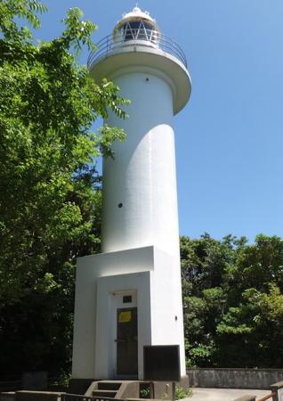
1952 (station established 1914). Active; focal plane 30 m (98 ft); one long white flash every 15 s. 17 m (56 ft) round cylindrical concrete tower with lantern and gallery, attached to a small 1-story concrete equipment room. Entire lighthouse is white. A photo is at right, Trabas has a closeup, Lighthouse-Japan.com has a page with several photos, FOAL's page has good photos, Lighthouse Visit also has a page for the light, additional photos and a closeup photo are available, and Google has a satellite view. Located on a promontory just off the coastal road, at the northern entrance to Beppu Bay, about 40 km (25 mi) northeast of Beppu city and 4 km (2.5 mi) east of Morie. Accessible by a paved walkway but there is no parking at the site; it's necessary to walk a sidewalk about 500 m (0.3 mi) from the Minosaki harbor west of the cape. Site open, tower closed. . ARLHS JPN-730; JCG-5000; Admiralty M4962; NGA 9421.

Usuishi Hana Light, Kitsuki, May 2016
Google Maps photo by mallorca
Morie Kō
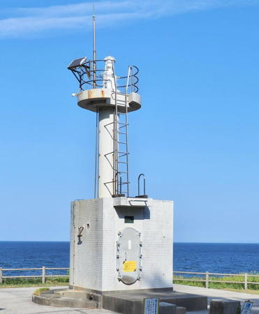
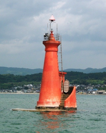
Date unknown. Active; focal plane 11 m (36 ft); one short and one long red flash every 8 s. 9 m (30 ft) round concrete tower rising from one end of an elliptical 1-story concrete base. Entire lighthouse painted red. A Coast Guard photo is at right, Trabas has a photo, FOAL's page for the light has photos, a 2023 photo is available, and Google has a satellite view. Morie Bay is a natural harbor sheltered by a long spit on its eastern side. The lighthouse is located on a sandbar just off the end of the spit. Accessible only by boat. Site open, tower closed. JCG-4999; Admiralty M4956; NGA 9416.

Beppu City Lighthouses
* Kamegawa Kō
Date unknown. Active; focal plane 14 m (46 ft); green flash every 3 s. 10 m (33 ft) round cylindrical concrete tower. Entire lighthouse is white. Trabas has a photo, FOAL's page has photos, Lighthouse Visit also has a page, a 2023 closeup is available, and Google has a satellite view and a street view across the harbor. Located at the end of the breakwater of Kamegawa harbor in northern Beppu. Accessible by walking the pier. Site open, tower closed. ARLHS JPN-2301; JCG-4998.5; Admiralty M4955; NGA 9408.
Beppu Outer Breakwater North Head
Date unknown. Active; focal plane 16 m (52 ft); green light, 2 s on, 2 s off. 16 m (52 ft) round cylindrical concrete tower with lantern and gallery. Entire lighthouse is white. Trabas has a photo, FOAL's page has photos (near the bottom of the page), Lighthouse Visit has photos (bottom of the page), Matsumoto-pota Masa has a 2018 photo, a 2023 photo and additional photos are available, and Google has a satellite view. The harbor of Beppu, at the head of Beppu Bay, is protected by a detached breakwater parallel to the shore. Located at the north end of the breakwater. Accessible only by boat. Site and tower closed. ARLHS JPN-2304; JCG-4998; Admiralty M4954.5; NGA 9404.
Beppu Outer Breakwater South Head
Date unknown. Active; focal plane 16 m (52 ft); red flash every 3 s. 16 m (52 ft) round cylindrical concrete tower with lantern and gallery. Entire lighthouse painted red. Trabas has a photo, FOAL's page has photos (near the top of the page), Matsumoto-pota Masa has a 2018 photo, a 2023 closeup, additional photos, and a 2013 view from an arriving ferry are available, and Google has a street view and a satellite view. The lighthouse was presumably built at the south end of the Beppu Outer Breakwater, but the breakwater has since been extended about 90 m (300 ft). Accessible only by boat. Site and tower closed. ARLHS JPN-2303; JCG-4997; Admiralty M4954; NGA 9400.


Morie Kō Light, Kitsuki
Japanese Coast Guard Ōita Office photo

Information available on lost lighthouses:

Notable faux lighthouses:

Adjoining pages: North: Kitakyūshū Area | South: Southern Ōita

Return to the Lighthouse Directory index | Ratings key

Posted June 25, 2007. Checked and revised March 11, 2024. Lighthouses: 22. Site copyright 2024 Russ Rowlett and the University of North Carolina at Chapel Hill.