Lighthouses of South Korea: Hansan

For most of its history Korea was an independent kingdom, or at least an autonomous kingdom under Chinese influence. This came to an end in 1910 when Japan annexed all of Korea. At the end of World War II in 1945 the 38° parallel was established as the dividing line between U.S. and Soviet zones of occupation, and in 1948 separate civil administrations were established in the two halves of the country. The Korean War (1950-53) ended in a draw with the armistice line falling close to the prewar 38° line. The Republic of Korea (ROK), commonly called South Korea, occupies the Korean peninsula south of the armistice line.

The name Korea, used internationally, is a Western version of Goryeo or Koryŏ (고려), the name of a kingdom that unified the country in the tenth century. From 1392 to 1897 the kingdom was known instead as Joseon or Chosŏn (조선). Today South Koreans usually call their country Hanguk (한국, literally "one country") and the official name of the Republic of Korea is Daehan Minguk (대한민국).

South Korea is divided into nine provinces and eight province-level cities. This page covers lighthouses of Hansan, a township (myeon) of the city of Tongyeong in southwestern Gyeongsangnam (South Gyeongsang) province on South Korea's south coast. Tongyeong (formerly called Chungmu) is a seaport at the end of the blunt Goseong Peninsula, separated from the island of Geojedo to the east by the island-strewn waters of Goeje Bay and from the island of Namhaedo to the west by the island-strewn waters of Goseong Bay. Hansan includes a series of islands extending southeast of Tongyeong into the Korea Strait south of Geoje. Hansan Island (Hansando) is the principal island of the township. It is famous in Korea as the site of Battle of Hansan Island, in which Korean Admiral Yi-Sun Sin defeated a much larger fleet of Japanese ships in August 1592.

Navigational aids in the ROK are regulated by the Ministry of Oceans and Fisheries (MOF). Management of lighthouses in Tongyeong is the responsibility of the Masan Regional Maritime Affairs and Port Office.

In 2000 South Korea adopted a Revised Romanization System to replace systems formerly used in the West. In the Revised System, the word for a lighthouse is deungdae (등대); dan (formerly tan) is a cape, seom (som) or do (to) is an island, am or amseog is a rock, man is a bay, and hang is a harbor. Some place names may be more familiar to Westerners in the spellings of older systems.

Special thanks to Kim Cheol Bong for permission to present his photos on this page.

ARLHS numbers are from the ARLHS World List of Lights. KR numbers, where available, are from the Korean light list published by the Korea Hydrographic and Oceanographic Agency. Admiralty numbers are from volume M of the Admiralty List of Lights & Fog Signals. U.S. NGA List numbers are from Publication 112.

General Sources
Online List of Lights - Korea
Photos by various photographers posted by Alexander Trabas.
Lighthouses to Visit
Information on three lighthouses provided by the Masan Office of Oceans and Fisheries.
Navionics Charts
Navigational chart for the Tongyeong area.
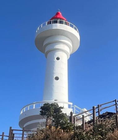

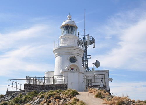
Somaemuldo Light, Korea Strait, December 2023
Instagram photo by Soonbong Kwon

Somaemuldo Area Lighthouses
These lighthouses are on a chain of islands extending south southwest from the island and city of Geoje.

Gaodo (Kaodo, Gawangdo)
Date unknown. Active; focal plane 17 m (56 ft); white flash every 6 s. 12 m (39 ft) round concrete tower, painted white. Kim Cheol Bong has a closeup photo and Google has a satellite view. This light and the next one frame an important passage for coastwise shipping. Gaodo is the northernmost island in a chain extending southward from the southern tip of Geojedo. The island is included in the Hallyeo Maritime National Park. Located on the southeastern tip of the island. Accessible only by boat. Site status unknown. KR-2176; Admiralty M4331.85; NGA 16876.5.
Eoyudo (Oyudo)
Date unknown. Active; focal plane 16 m (52 ft); white flash every 6 s. 12 m (39 ft) round cylindrical concrete tower rising from a round concrete base. Entire lighthouse is white. Do Jae Bok has a 2021 photo, Kim Cheol Bong has a 2018 view from the sea, and Google has a satellite view. Located on the northern tip of Eoyudo, about 3 km (2 mi) south of the Gaodo lighthouse. Accessible only by boat. Site status unknown. KR-2171; Admiralty M4334.5; NGA 16876.7.
* Danggeum (Maemuldo) Hang North Breakwater
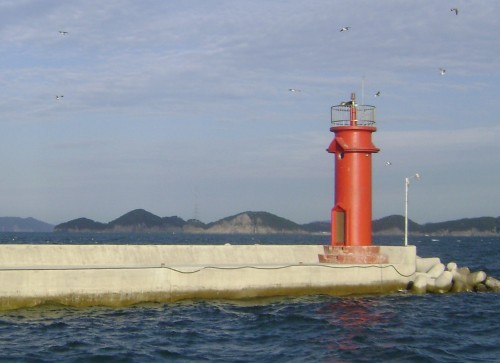
Date unknown. Active; focal plane 14 m (46 ft); red flash every 5 s. 8 m (26 ft) round cylindrical concrete tower. Entire lighthouse is red. Kim Cheol Bong's photo is at right, a 2019 photo is available, and Google has a satellite view. Located on the main breakwater of Danggeum harbor on Maejukdo, an island to the north of Somaemuldo. Accessible by walking the pier. Site open, tower closed. KR-2171.5; Admiralty M4334.2; NGA 16873.
** Somaemuldo (Somaemul To) (2)
Date unknown (station established 1917). Active; focal plane 91 m (299 ft); white flash every 13 s. 13 m (43 ft) round cylindrical concrete tower with lantern and two galleries. Lighthouse painted white; the lantern, formerly white, is now painted red. 2-story keeper's house and other light station buildings. Soonbong Kwon's photo is at the top of this page, JongHoo Lee has a 2015 photo, Yang Soon Park has a nice view, HankYu Lee has a street view, and Google has a satellite view. This is not the original lighthouse, which had a focal plane of 83.5 m (274 ft). This lighthouse helps guide vessels through the narrow passage of the Korea Strait. Somaemuldo is the southernmost in a chain of precipitous rocky islands extending southward from the southern tip of Geojedo. The island is included in the Hallyeo Maritime National Park. The lighthouse is actually located on a smaller island, Deungdaesum ("Lighthouse Island"), which is joined to Somaemuldo by a causeway at low tide. Located at the highest point of the island. Accessible by boat or, with caution, on foot at low tide. Site open, visitors can climb to the lower gallery by an external stair, tower closed. . ARLHS SKR-026; Admiralty M4332; NGA 16872.

Danggeum Hang North Breakwater Light, Tongyeong, May 2018
ex-Google Plus photo by Kim Cheol Bong
Deunggado
Date unknown. Active; focal plane about 19 m (62 ft); light characteristic unknown. Approx. 18 m (59 ft) round cylindrical concrete tower with gallery painted black with one red horizontal band. Kim Cheol Bong has a photo and Bing has a satellite view. Located on a rocky reef about 3.5 km (2.25 mi) southeast of Somaemuldo. Accessible only by boat. Site status unknown. KR-2172.2; Admiralty M4334.4.
Daegueulbido
Date unknown. Active; focal plane 24 m (79 ft); two white flashes every 5 s. 18 m (59 ft) round cylindrical concrete tower with gallery, mounted on a round concrete pier. An external stairway spirals around the tower. Lighthouse painted black with one red horizontal band. Kim Cheol Bong has a photo, Dohyung Kim has a 2022 photo, and Google has a satellite view. Located on a rocky reef about 4 km (2.5 mi) south of Somaemuldo. Accessible only by boat. Site status unknown. KR-2172.3; Admiralty M4332.2.
Sojido
Date unknown. Active; focal plane 43 m (141 ft); white flash every 6 s. 7 m (23 ft) round white concrete tower. Kim Cheol Bong has a closeup photo and a view from the sea and Bing has a satellite view. Located at the east end of an island about 7 km (4 mi) west of Somaemuldo. Accessible only by boat. Site status unknown. Admiralty M4332.5; NGA 16875.
Hongdo (Gyeongsang Hong Do)
1906. Reactivated(?); focal plane 117 m (384 ft); white flash every 10 s. 8 m (26 ft) round concrete tower with lantern and gallery, attached to a 1-story concrete keeper's house. Entire lighthouse painted white. A photo appears at right, Kim Young Ho has a distant view from the sea, and Google has a satellite view. It appears that at some point the active light was moved from the lantern to a square skeletal tower mounted atop the keeper's house, and the 2009 NGA List described the light as a "framework structure." However, the Fresnel lens remained mounted in the tower. A 2009 photo shows that the skeletal tower has been converted to a communications tower, and presumably the light is back in the lantern. Caution: there is another, much better-known Hongdo lighthouse off the southwestern tip of Korea (see the Heuksan Islands page). The name Hongdo ("red island") is common in Korea. This Hongdo is an isolated island in the Korea Strait about 20 km (13 mi) southeast of the southern tip of Geojedo: it is the southeasternmost land of Korea. The island is closed to the public as a nature reserve to protect endangered black-tailed gulls. Accessible only by boat. Site and tower closed. KR-2170; Admiralty M4334; NGA 16864.

Hongdo Light, Korea Strait, June 2016
photo by Park Sang-geon posted by Seoul Weekly

Hansando East Coast Lighthouses
Hansando (Hansan Island) is an island about 8 km (5 mi) long southeast of Tongyeong and southwest of Geoje. Bongamdo (Chubongdo) is a smaller island that extends west to east off the southeastern side of Hansando, partially closing the entrance to Geoje Bay.
Pisando
Date unknown. Active; focal plane 10 m (33 ft); green flash every 6 s. 11 m (36 ft) round cylindrical concrete pier with double gallery, mounted on a round concrete pier. Entire lighthouse is green. Kim Cheol Bong has a photo and Google has a satellite view. Located just off the northeastern corner of Hansando, marking a very narrow passage around the island. Accessible only by boat, although there's a close view from shore. Site open, tower closed. KR-2196; Admiralty M4330.8; NGA 16899.
Sogopo
2018. Active; focal plane 14 m (46 ft); green flash every 5 s. 14 m (46 ft) round concrete tower. Entire lighthouse is green. A 2021 photo is available, another photo shows this light and the next one, and Google has a satellite view. This light and the next one frame a narrow channel off the east coast of Hansando between that island and Seojwado. Accessible only by boat, although there's a close view from shore. Site open, tower closed. KR-2186.3; Admiralty M4330.85.
Seojwado
Date unknown. Active; focal plane about 14 m (46 ft); red flash every 5 s (?). Approx. 14 m (46 ft) round concrete tower. Entire lighthouse is red. A photo shows this light and the previous one and Google has a satellite view. Located about 200 m (1/8 mi) southeast of the Sogopo lighthouse. Accessible only by boat, although there's a close view from shore. Site open, tower closed. KR-2186.2; Admiralty M4330.9.

Bongamdo, Yonghodo and Bijindo Lighthouses
Bongamdo (Pongamdo, Chubongdo)
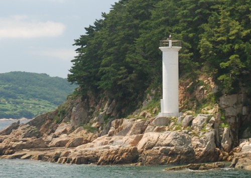
Date unknown. Active; focal plane 22 m (72 ft); white flash every 6 s. 13 m (43 ft) round concrete tower, painted white. A photo is at right, Kim Cheol Bong has a photo, and Google has a satellite view. Bongamdo is an island off the southeastern tip of Hansando. Located at the eastern end of the island, marking the beginning of a sheltered route to Tongyeong along the southwest side of Geojedo. Site status unknown. KR-2185; Admiralty M4330.7; NGA 16898.
Bongamdo Light
Bongamdo (Chubongdo) Light, Geoje Man, August 2009
Wikimedia Creative Commons photo by Asfreeas
Soyeo (Cheolcho)
Date unknown. Active; focal plane 11 m (36 ft); red flash every 4 s. 10 m (33 ft) round strongly tapered concrete tower, painted red. Kim Cheol Bong has a 2018 photo and Google has a satellite view. Located on a reef off the southwestern point of Bongamdo. Accessible only by boat. Site open, tower closed. KR-2182; Admiralty M4331; NGA 16900.
* Hodu Hang West Breakwater
Date unknown. Active; focal plane 12 m (39 ft); red flash every 4 s. 8 m (26 ft) round cylindrical concrete lighthouse, painted red. Kim Cheol Bong has a closeup photo and a photo of both breakwater lighthouses, and Google has a satellite view. Hodu is fishing port on the north side of Yonghodo, an island off the south end of Hansando; a recent project has built new breakwaters for the harbor. Located at the end of the west breakwater of Hodu. Accessible by walking the pier. Site open, tower closed. KR-2182.2; not listed by the Admiralty.
* Hodu Hang East Breakwater
Date unknown. Active; focal plane 12 m (39 ft); green flash every 4 s. 8 m (26 ft) round cylindrical concrete lighthouse, painted white. Kim Cheol Bong has a closeup photo and Google has a satellite view. Located at the end of the east breakwater of Hodu. Accessible by walking the pier. Site open, tower closed. KR-2182.1; not listed by the Admiralty.
Gaksuseo (Kaksu-so)
Date unknown. Active; focal plane 15 m (45 ft); two white flashes every 5 s. 13 m (43 ft) round cylindrical concrete tower, painted black with a red horizontal band. Kim Cheol Bong has a 2018 photo, Do Jaebok has a 2021 photo, and Google has a satellite view. Located about 1.2 km (3/4 mi) off the southwestern tip of Hansando and a similar distance off the western tip of Yonghodo. Accessible only by boat. Site open, tower closed. KR-2184; Admiralty M4331.5; NGA 16896.
* Naehang Hang Breakwater
Date unknown. Active; focal plane 12 m (39 ft); red flash every 4 s. 8 m (26 ft) round cylindrical red concrete tower. A photo is at right, Kim Cheol Bong has a closeup photo and a distant view nd Google has a satellite view. Located at the end of the breakwater of Naehang Hang at the northwestern end of Bijindo, an island just southwest of Yonghodo. Accessible by walking the pier. Site open, tower closed. KR-2184.7; Admiralty M4331.515; NGA 16887.5.
Bijindo Breakwater Light
Naehang Hang Breakwater Light, September 2008
Flickr Creative Commons photo by kilim
Bakkatsodangyeo
2021. Active; focal plane 11 m (36 ft); nine quick white flashes every 15 s. 9 m (30 ft) round concrete tower painted yellow with a black horizontal band. No photo available but Google has an indistinct satellite view. Kim Cheol Bong has a 2013 photo of this reef, taken before there was a light; notice the Naehang Hang lighthouse in the distance. Located on a reef about 300 m (0.2 mi) west of the Naehang Hang Breakwater. Accessible only by boat. Site open, tower closed. KR-2184.6; Admiralty M4331.518.
Jakdo
Date unknown. Active; focal plane 12 m (39 ft); two white flashes every 5 s. 13 m (43 ft) round concrete tower painted black with one red horizontal band. Kim Cheol Bong has a photo and Bing has a satellite view. Located on a reef about 1.5 km (1 mi) east of the southern tip of Bijindo. Accessible only by boat. Site open, tower closed. KR-2184.5; Admiralty M4331.52.

Hansando South and West Coast Lighthouses
* Hapo Hang
Date unknown. Active; focal plane 12 m (39 ft); green flash every 4 s. 8 m (26 ft) round cylindrical concrete lighthouse styled to resemble a birdhouse. Entire lighthouse is white. Kim Cheol Bong has a closeup photo and Google has a satellite view. Located on the breakwater of a small harbor near the southwestern tip of Hansando. Accessible by walking the pier. Site open, tower closed. KR-2183.5; Admiralty M4331.15; NGA 16886.7.
* Jangjakji (Changjakji) Hang
Date unknown. Active; focal plane 12 m (39 ft); red flash every 4 s. 8 m (26 ft) round hourglass-shaped concrete lighthouse, painted red. Kim Cheol Bong has a 2018 photo and Google has a satellite view. Located on the breakwater of a small harbor on the southwest coast of Hansando. Accessible by walking the pier. Site open, tower closed. KR-2183.7; Admiralty M4331.25; NGA 16902.
Hansan Hang ("Turtle Ship Lighthouse")
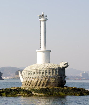
Date unknown. Active; focal plane 13 m (43 ft); white flash every 4 s. 13 m (43 ft) white concrete post light, mounted on a concrete pier sculpted in the form of a medieval "turtle ship." Kim Cheol Hwan's photo is at right, Han Jeong Won has a 2017 photo, Peta Berry has another photo, and Google has a distant satellite view. This unusual light honors the famous Korean admiral Yi Sun-Sin, who defeated Japanese invading fleets with a much smaller fleet of turtle ships in the 1590s. A replica of a turtle ship is a well known attraction in Tongyeong. Located on a shoal in the harbor of Hansan, a deep inlet on the northwestern coast of Hansando. Accessible only by boat. Site open, tower closed. KR-2194; Admiralty M4325; NGA 16908.

Information available on lost lighthouses:

Notable faux lighthouses:

Hansan Hang Light
Hansan Hang (Turtle Ship) Light, Hansan, October 2007
ex-Panoramio Creative Commons photo by Kim Cheol Hwan

Adjoining pages: North: Geoje | Northwest: Tongyeong

Return to the Lighthouse Directory index | Ratings key

Posted December 4, 2007. Checked and revised January 6, 2024. Lighthouses: 22. Site copyright 2024 Russ Rowlett and the University of North Carolina at Chapel Hill.