Lighthouses of Southwestern Morocco

The Kingdom of Morocco (al-Mamlakah al-Maghribiyah in Arabic) occupies the northwestern corner of Africa across the Strait of Gibralter from Spain. It has a long coast facing northwest on the Atlantic Ocean and a much shorter coast facing north on the easternmost Mediterranean Sea. During most of the nineteenth century France, Spain, and other European countries maneuvered to gain control of Morocco. In 1912 it was finally divided; although the monarchy remained in place France and Spain assumed formal protectorates over the country. The French protectorate included the northwestern coast from the Agadir area through Mehdia, while Spain had a protectorate over the northern coast and portions of the far south. In 1923 the northwestern city of Tangier was removed from the Spanish sector to become an international zone. Morocco resumed its independence in 1956 but Spain continues to control the northern cities of Ceuta and Melilla and several small islands off the Mediterranean coast.

For lighthouse fans the implication of this history is that Morocco's lighthouse heritage is partly Spanish and partly French, with French influence seen in the west and Spanish influence to the north and south. However, the design of lighthouses in all parts of the country shows a strong native Moroccan style.

This page includes lighthouses of Morocco's southwest coast, facing the Atlantic Ocean south of the Casablanca area. Included are five of Morocco's twelve administrative regions. There are separate pages for Northwestern Morocco, Northeastern Morocco and the Spanish Coast of Morocco (including Ceuta and Melilla).

Included on this page are the lighthouses of Western Sahara. Western Sahara is the former Spanish Sahara, a large, lightly populated desert territory south of Morocco and northwest of Mauritania. When Spain withdrew from its colony in 1976 the territory was occupied by troops from Morocco and Mauretania. The Mauritanians withdrew in 1979 and since that time Morocco has occupied more than half of Western Sahara, including all of the coast except a very short section at the southern end. Wikimedia has a map showing the division of the territory. In general this occupation is not recognized internationally, although in 2020 the Trump administration in the United States recognized Moroccan sovereignty over Western Sahara in exchange for Moroccan normalization of relations with Israel. In this listing the lighthouses of the Dakhla, Boujdour and Laâyoune areas are in the disputed territory.

Please note that the Lighthouse Directory takes no position and has no comment on any international territorial dispute. Our only task is to describe lighthouses. The lighthouses of Western Sahara are listed under Morocco because Morocco operates them.

Arabic and Berber are the official languages in Morocco. Darija (a Berber-influenced dialect of Arabic) and French are common spoken languages. The Arabic word for a lighthouse is mnarh or manara (منارة). Ra's is the word for a cape or headland and jazira is an island.

Lighthouses in Morocco are operated by the Etablissements de Signalisation Maritime (ESM) division of the infrastructure ministry (Ministère de l'Équipement et de l'Eau).

ARLHS numbers are from the ARLHS World List of Lights. Admiralty numbers are from volumes D and E of the Admiralty List of Lights & Fog Signals. U.S. NGA List numbers are from Publication 113.
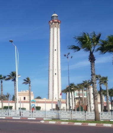

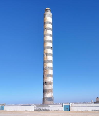
Ra's Boujdour (Cabo Bojador) Light, Boujdour, May 2023
Google Maps photo by Elly Raza

General Sources
Online List of Lights - Morocco Atlantic and Western Sahara
Photos by various photographers posted by Alexander Trabas.
Lighthouses in Morocco and Lighthouses in Western Sahara
Photos by various photographers available from Wikimedia.
World of Lighthouses - Morocco and Western Sahara
Photos by various photographers available from Lightphotos.net.
Phares d'Afrique
Photos by various photographers posted by Alain Guyomard and Robert Carceller.
Leuchttürme in Marokko
Photos taken in October 2017 by Andreas Köhler.
A Tour of Morocco's Lighthouses
Photos and brief descriptions of some of the country's best known lighthouses.
Phares du Maroc
A page posted by ESM linking to postcard images of the major lighthouses.
Afrikanische Leuchttürme auf historischen Postkarten
Historic postcard images posted by Klaus Huelse.
GPSNavigationChart
Navigation chart information for Morocco.
Navionics Charts
Navigation chart for Morocco.

Cap Sim Light, Essaouira
postcard photo posted by ESM

Dakhla-Oued Ed-Dahab Region Lighthouses

Far Southern Coast Lighthouses
Cap Barbas
1969. Active (?); focal plane 56 m (184 ft); three white flashes every 12 s. 40 m (131 ft) round cylindrical tower, painted with black and white horizontal bands. A 2021 photo is available and Google has a good satellite view. The lighthouse is very similar to the El Cabiño lighthouse (see below). Located on a bluff at the point of the cape about 225 km (140 mi) south southwest of Dakhla and 20 km (12.5 mi) northeast of the fishing village of Lamhiriz. Site status unknown; this is a remote and desolate coast. ARLHS WSA-004; Admiralty D2975.6; NGA 24332.
Bahía de Angra de Cintra (Punta de las Raimas)
Date unknown. Probably inactive but listed with focal plane 13 m (43 ft); four white flashes every 10 s. 10 m (33 ft) hexagonal masonry tower. No photo available but Google has a satellite view. Located on a headland at the northern entrance to the bay, about 100 km (60 mi) south of Dakhla. There are no port facilities at this bay. Site status unknown. ARLHS WSA-002; Admiralty D2975; NGA 24320.

Dakhla Lighthouses
Dakhla, called Villa Cisneros under the Spanish, is a city of about 105,000 inhabitants. Dakhla stands near the end of a long sandy peninsula enclosing the estuary of Oued ed-Dahab, one of the few good harbors along the Saharan coast. Under Spanish control Villa Cisneros was the capital of Río de Oro, a territory including about 2/3 of Spanish Sahara. From 1975 to 1979, as Dakhla, it was the capital of the territory occupied by Mauritania called Tiris al-Gharbiyya (West Tiris).

Punta Galera (La Sarga, Punta Durnford)
Date unknown. Active; focal plane 12 m (39 ft); two white flashes every 6 s. 6 m (20 ft) square castellated tower, painted white and attached to a larger structure. A tall radar tower stand beside the lighthouse. Mouctar Diaby has a 2020 photo, Abdel Khmissou has a distant view, and Google has a satellite view. Located at the southeastern tip of the Dakhla peninsula, marking the entrance to the estuary of Oued ed-Dahab (Río de Oro). Site status unknown. ARLHS WSA-008; Admiralty D2973; NGA 24316.
** Dakhla (Arciprés Grande, Villa Cisneros) (1)
1916. Inactive. Approx. 10 m (33 ft) round cylindrical rubblestone tower attached to one corner of a Spanish fort. Lightphotos.net has a closeup photo, Abu Marwa Safi has a photo, Wikimedia has a photo, and Google has a satellite view. Although the fort may have been built in 1884 as some sources claim, there does not seem to have been a lighthouse prior to 1916. Located next to the historic lighthouse.
** Dakhla (Arciprés Grande, Villa Cisneros) (2)
Date unknown. Active; focal plane 76 m (249 ft); white flash every 5 s. 50 m (164 ft) round cylindrical concrete tower with lantern and gallery. The lighthouse is white concrete painted with narrow black horizontal bands; the lantern and gallery are black. Khallok Al Abdel has the 2023 photo seen at right, Trabas has Eckhard Meyer's photo, a good 2013 photo is available, Lightphotos.net has a closeup photo, Wikimedia has several good photos, Lighthouse Digest has a good photo contributed by Michel Forand, Andrius Rybakovas has a street view, and Google has a good satellite view. Located on a headland of the peninsula a short distance northwest of Dakhla. Site open; the tower is apparently open for climbing. . ARLHS WSA-001; Admiralty D2972; NGA 24308.

Dakhla Light, Dakhla, September 2023
Google Maps photo by Khallok Al Abdel

Laâyoune-Sakia El Hamra Region Lighthouses

Boujdour Area Lighthouses
Cape Bojador (Ra's Bujadur), one of the more prominent capes along the northwest African coast, represented the end of the known world for Europeans until the Portuguese navigator Gil Eanes sailed beyond it in 1434. Passing the cape was considered dangerous for vessels sailing close to the coast; the Arabic name for the cape is Abu Khatar, "Father of Danger." The modern town of Boujdour (Cabo Bojador) has a population of about 45,000.

Peña Grande
Date unknown. Active; focal plane 173 m (568 ft); four white flashes every 15 s. 11 m (36 ft) round tower, painted with black and white horizontal bands. Keeper's house, probably in ruins. No photo available but Google has a satellite view. Located on heights above a prominent cape about halfway between Boujdour and Dakhla. Site status unknown. ARLHS WSA-006; Admiralty D2631; NGA 24304.
Punta del Corral
Date unknown. Active; focal plane 71 m (233 ft); two white flashes every 9 s. 11 m (36 ft) round tower, painted with black and white horizontal bands. No photo available but Google has a satellite view. Located atop a steep bluff about 65 km (40 mi) south of Boujdour. Site status unknown. ARLHS WSA-007; Admiralty D2630; NGA 24300.
* Ras Boujdour West End
Date unknown. Inactive, although still listed. 6 m (20 ft) square pyramidal rubblestone tower, unpainted. The tower carried a red light, flashing once every 5 s at a focal plane of 9 m (30 ft). However, Fenouri Noureddine's 2017 photo shows no light. Google has an indistinct satellite view. Located on the beach at the point of the cape. Site open, tower closed. Admiralty D2628.2; NGA 24296.
* Ras Boujdour (Cabo Bojador, R'as Abu Khatar)
1956 (station established 1903). Active; focal plane 70 m (230 ft); three white flashes every 15 s. 45 m (148 ft) octagonal masonry tower with lantern and gallery, attached to a large 1- and 2-story keeper's house. The lighthouse is unpainted; although NGA mentions a "black stripe," this is really darker stone placed along the angles of the tower. Elly Raza's photo is at the top of this page, Wikimedia has the same photo, Lahcen Akchairi has a 2017 photo, Adnane Echcharfy has a 2022 photo, Trabas has Eckhard Meyer's photo, Lightphotos.net has a good photo, and Google has a satellite view. Located near the center of the town of Boujdour. Site open, tower closed. ARLHS WSA-003; Admiralty D2628; NGA 24292.
El Cabiño (1)
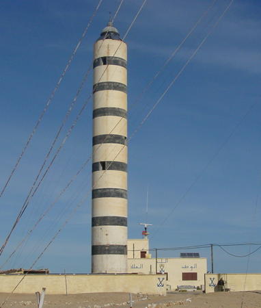
Date unknown. Inactive since about 2020. 32 m (105 ft) round cylindrical conical tower with lantern. The tower is white concrete painted with narrow black horizontal bands. 2-story crew quarters building. Rui Ornelas's photo is at right, he also has a good view from the beach, Wikimedia has a closeup photo also by Ornelas, and Google has a satellite view. Endangered: the lighthouse is very close to the water. Fortunately there is little danger of severe storms on this desert coast. Located on a prominent but misleading cape ("Faux Cap Bojador") about 35 km (22 mi) northeast of Boujdour. Site open, tower closed. ARLHS WSA-005.
El Cabiño (2)
Around 2020. Active; focal plane 36 m (118 ft); three white flashes every 12 s. Approx. 32 m (105 ft) square skeletal tower. No photo available but Google has a satellite view. No less endangered than the original lighthouse, as the two stand side by side. Site open, tower closed. Admiralty D2626; NGA 24288.

El Cabiño Light, Boujdour, February 2002
Wikimedia Creative Commons photo by Rui Ornelas

Laâyoune Area Lighthouses
El-Aaiún (Laâyoune) Phosphate Pier
Date unknown. Active (privately maintained); focal plane 46 m (151 ft); white flash every 5 s. 42 m (138 ft) square cylindrical phosphate silo. No photo available but Google has a satellite view. Laâyoune (El-Aaiún) is the regional capital and the largest city of the former Western Sahara with a population of about 225,000; it was the capital of Spanish Sahara from 1940 to 1975. The city is inland; its small port area is about 25 km (15 mi) to the southwest. The phosphate pier extends about 2.5 km (1.5 mi) into the Atlantic to reach deep water. Note: This is the northernmost light in the disputed territory of Western Sahara. Located at the end of the pier. Site and tower closed. Owner/site manager: OCP Group. Admiralty D2623; NGA 24276.

Tarfaya Lighthouses
* Tarfaya (Cabo Juby) (2)
1986 (probably a reactivation of an older light). Active; focal plane unknown; two white flashes every 10 s. 13 m (42 ft) round masonry tower; the light is displayed from a mast atop the tower. Tower unpainted. ESM's postcard image is at right, Sea-seek.com has a fuzzy photo, and Google has a satellite view. This is a historic tower on which a modern light has been installed. Cabo Juby is a prominent cape, the closest point of the mainland to the Canary Islands. This area, known as Cabo Juby and more recently as the Tarfaya Strip, was controlled by Spain from 1916 until 1958. Tarfaya was called Villa Bens under Spanish rule. Located on the cape in the town of Tarfaya. Site open, tower closed. ARLHS MOR-038; Admiralty D2619; NGA 23270.
Tarfaya (Cabo Juby) (1) Casa del Mar
Date unknown. Inactive since the 1940s. The light was mounted on a corner of the now-ruined fortress of Casa del Mar. Wikimedia has a photo, Ilias Lakhmasse has a street view from the shore, and Google has a satellite view. The fortress was built by the British in the 1880s but they occupied it for only a few years. The light was added much later; it is known to have been active in the 1940s. Rising sea levels and beach erosion have caused the ruined fortress to go to sea. Located just off the waterfront of Tarfaya. Accessible only by boat, but there's a good view from the beach. Site open.

Tarfaya (Cabo Juby) Light, Tarfaya
postcard photo posted by ESM

Guelmim-Oued Noun Region Lighthouses

El Ouatia (Tan-Tan) Lighthouses
* El Ouatia (Tan-Tan) Harbour Master's Office
Date unknown. Active; focal plane unknown, very quick-flashing light, white, red or green depending on direction. Approx. 10 m (33 ft) square tower rising from a waterfront building. A 2019 photo is available, Abdelwahed Elhaouzi has a distant view, and Google has a satellite view. Located on the waterfront of the small boat harbor at El Ouatia. Site open, tower closed. Admiralty D2618.3.
El Ouatia (Cabo Nachtigal, Tan-Tan-Plage) (2?)
Date unknown (station established 1977). Active; focal plane 36 m (118 ft); white flash every 5 s. 7 m (23 ft) tower described by NGA as painted red with a white band. No photo available. but Google has a satellite view. The history of this light is not clear. The Admiralty formerly placed the light in the city and a location pointing to the city's mosque, which would have the proper height, but photos of the mosque do not show a light. El Ouatia (Tan-Tan-Plage) is a small coastal settlement in the Tarfaya Strip. This is probably a modern light added by Morocco after it assumed administration of the area. Located atop a steep bluff above the harbor. Site status unknown. ARLHS MOR-016; Admiralty D2617; NGA 23264.
Cap Drâa
1999. Active; focal plane 85 m (279 ft); two white flashes every 10 s. 30 m (98 ft) square skeletal communications tower, described by NGA as painted with black and white horizontal bands. A street view is available and Google also has a satellite view. The Cap Drâa area is the site of NATO training exercises and the offshore area has been opened to oil exploration. Located in a desolate area about 40 km (25 mi) northeast of Tan-Tan-Plage. Site status unknown. ARLHS MOR-041; Admiralty D2616.6; NGA 23260.

Souss-Massa Region Lighthouses

Ifni Lighthouses
Morocco ceded Ifni and the surrounding area to Spain in 1859 but there was little Spanish settlement there until 1934, when the town was established as the residence of the governor of Spanish Sahara (now called Western Sahara). After Morocco resumed independence in 1956 Ifni remained Spanish until 1969, when Spain agreed to return the territory.

Sidi Ifni Jetty
Date unknown. Active; focal plane 11 m (36 ft); red light, 2 s on, 2 s off. 8 m (26 ft) round cylindrical tower painted red with a white horizontal band. A distant view and second distant view are available and Google has a satellite view. Located on the main breakwater at Sidi Ifni. Site status unknown. Admiralty D2616.4; NGA 23258.
* Sidi Ifni (2)
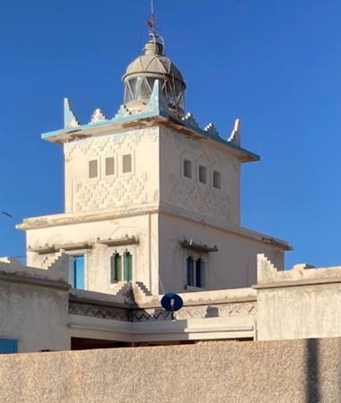
1949 (station established 1936?). Active; focal plane 57 m (187 ft); four white flashes, in a 1+3 pattern, every 30 s. 13 m (43 ft) square cylindrical masonry tower with lantern and gallery, rising from a 2-story building. Lighthouse painted white; lantern dome is black. A 2023 photo is at right, Prudencio Juan Nieto has a 2018 photo, Alberto Pedrotti has a 2011 photo, Trabas has a photo by Capt. Peter Mosselberger, and the lighthouse is centered in a Google satellite view. The town sits on a plateau above the sea and a small harbor. Located atop the plateau in the center of town, just off the former Plaza de España, now the Place Hassan II. Site open, tower closed as far as is known. ARLHS MOR-012; Admiralty D2616; NGA 23256.

Sidi Ifni Light, Ifni, January 2023
Google Maps photo by ŽaniB

Agadir Area Lighthouses
Agadir is a large city with a population exceeding one million. It includes an important port and is the economic center of southern Morocco. The city was flattened by a great earthquake on 29 February 1960 and it has been rebuilt almost entirely since then.
Cap d'Aglou
2004. Active; focal plane 53 m (174 ft); three white flashes, in a 2+1 pattern, every 12 s. Described by NGA as a 20 m (66 ft) "metal pylon," it appears that this light is mounted on a tall communications tower seen in Google's satellite view. A distant view is available. Located on heights about 3 km (1.8 mi) from the coast and 40 km (25 mi) northeast of Sidi Ifni. Site status unknown. Admiralty D2615; NGA 23255.5.
Agadir Grande Jetée (Jetée Ouest) (2)
Date unknown. Active; focal plane 8 m (26 ft); red light occulting twice every 6 s. 7 m (23 ft) mast centered on a square concrete tower, painted red. Fog horn (two 2 s blasts every 30 s). No photo of the current light available. Trabas has Hartmut Knape's photo and Google has a satellite view. The lighthouse marks the entrance to the most important port of southern Morocco. Located at the end of the west breakwater. Site and tower closed. ARLHS MOR-040; Admiralty D2611; NGA 23244.
Port d'Anza Northwest Jetty (East Breakwater)
Date unknown. Active; focal plane about 11 m (36 ft); green flash every 4 s. 8.5 m (28 ft) round barbell-shaped tower, white with a green band at the top. Trabas has Helmut Seger's photo, Köhler has a photo, and Google has an indistinct satellite view. Located in the commercial harbor on the west side of Agadir. Site and tower closed. Admiralty D2613.2; NGA 23254.
**** Cap Rhir (Cap Ghir)
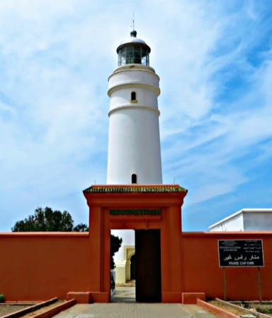
1932. Active; focal plane 85 m (279 ft); white flash every 5 s. 41 m (135 ft) round masonry tower with lantern and gallery. Entire lighthouse painted white; lantern roof is unpainted metallic. 1-story keeper's houses and other buildings within a walled enclosure. A 2023 photo is at right, Andreas Köhler contributed a good 2017 photo, Trabas has Eckhard Meyer's photo, Moustafa Idrissi Hassani has a 2017 photo, Lightphotos.net has a closeup, and Google has a good satellite view. This lighthouse, the southernmost lighthouse of the former French protectorate, marks one of the most prominent capes of the Morocco's Atlantic coast. Located atop the cape, beside the main coastal highway (N1) about 40 km (25 mi) northwest of Agadir. Site open, and staff will conduct tours of the tower. . ARLHS MOR-005; Admiralty D2608; NGA 23236.
* Imsouane
Date unknown. Inactive. Approx. 16 m (52 ft) round cylindrical concrete tower with gallery; lantern removed. Tower painted red (now faded to pink), gallery blue. A 2018 photo is available, Wikimedia also has a 2018 photo, and Bing has a satellite view. Imsouane is a small fishing town about 25 km (15 mi) north of Cap Rhir. Located on the waterfront at Imsouane. Site open, tower closed.

Cap Rhir Light, Agadir, May 2023
Google Maps photo by Pepa

Marrakesh-Safi Region Lighthouses

Essaouira Area Lighthouses
Cap Sim
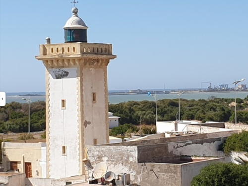
1917. Active; focal plane 103 m (338 ft); three white flashes every 15 s. 20 m (66 ft) square stone tower with lantern and gallery, rising in the center of a fort. Light tower painted green with narrow white horizontal bands; the lantern and gallery are white. ESM's postcard image is at the top of this page, Lightphotos.net has a photo, and Google has a satellite view. Located on a cape about 20 km (13 mi) south of Essaouira. Site open but reported difficult to reach, tower closed. ARLHS MOR-019; Admiralty D2604; NGA 23232.
* Sidi Magdul (Sidi Megdoul, Mogador, Essaouira) (2)
1916 (station established 1903). Active; focal plane 19 m (62 ft); white, red, or green light, depending on direction, occulting every 4 s. 15 m (49 ft) square cylindrical masonry tower with lantern and gallery. Tower painted white with gold trim; lantern painted black. Rachid Haloui has the 2021 photo seen at right, Roland Gaese has a 2019 photo, Joe Katrencik has an excellent 2008 photo, Lightphotos.net has a photo, another photo is available, Trabas has Arno Siering's view from the sea, Huelse has a historic postcard view, and Google has a satellite view. Located beside highway 207 on the south end of the harbor at Essaouira. Site open, tower closed. ARLHS MOR-036; Admiralty D2602; NGA 23216.
Cap Hadid
2007. Active; focal plane 48 m (157 ft); two white flashes every 15 s. 30 m (98 ft) skeletal tower. Köhler has a photo and Google has a good satellite view. Located on a headland about 25 km (15 mi) northeast of Essaouira. Site and tower closed. Admiralty D2601; ex-NGA 23214.

Safi Area Lighthouses
Safi Môle des Phosphates
Date unknown. Inactive since 2015. 27 m (89 ft) square tower rising from a waterfront building. Abdo Bounouh has a photo and a Google satellite view shows the building. Located on a pier in Safi. Site status unknown. ARLHS MOR-046; ex-Admiralty D2600.2; ex-NGA 23212.

Sidi Magdoul Light, Essaouira, April 2021
Google Mpas photo posted by ESM
Safi Grande Jetée
Date unknown. Active; focal plane 12 m (39 ft); green light, 2 s on, 2 s off. 11 m (36 ft) concrete post attached to a square 1-story equipment shelter. Entire lighthouse is green. Trabas has Andreas Köhler's photo, Hamza Jaouad has a view from the sea, and Google has a satellite view. Located at the end of the main breakwater of Safi. Site and tower closed. Admiralty D2596; NGA 23196.
Safi Entrance
Date unknown. Active; focal plane about 23 m (75 ft); red light, pattern unknown. Approx. 20 m (66 ft) square skeletal tower. Houssame Same has a 2021 street view, Squalli Imane has a 2019 view, the light is at the right in Abdo Bounouh's photo, and Google has a satellite view. Located on the east side of the Safi harbor opposite the Grand Jetée. Site and tower closed. Not listed by the Admiralty.
Pointe de la Tour (Borj Nador)
1957. Active; focal plane 90 m (295 ft); white light occulting four times every 12 s. 12 m (39 ft) square cylindrical tower with lantern and gallery rising from one end of a keeper's house. Lighthouse painted white, lantern green. Badr Issaad has a closeup 2024 photo and a more distant view, Noureddine Jebbar has a 2019 photo, a view from above is available, Trabas has Köhler's blurry distant view, and Google has a satellite view. Located on the slope of a prominent headland about 6 km (4 mi) northwest of Safi. Site and tower closed (military base). ARLHS MOR-031; Admiralty D2595; NGA 23180.
* Cap Beddouza (Cap Cantin)
1916. Active; focal plane 65 m (213 ft); two white flashes every 10 s. 19 m (62 ft) square stone tower with lantern and gallery, located in the center of a large square fort. Fort and lighthouse painted white; the lighthouse and the other towers of the fort also have green horizontal bands. Arno Siering's closeup photo is seen at right, Trabas has Eckhard Meyer's photo, Jean-Marc Favre has a fine 2007 photo, Wikimedia has Brahim Faraji's photo, a 2023 photo and another photo is available, Huelse has a historic postcard view, and Google has a satellite view. The area is accessible by road (highway 301). Located on a very prominent cape about 50 km (30 mi) north of Safi. Site open, tower closed. ARLHS MOR-014; Admiralty D2592; NGA 23176.

Cap Beddouza Light, Safi
photo copyright Arno Siering; used by permission

Information available on lost lighthouses:

Notable faux lighthouses:

Adjoining pages: North: Northwestern Morocco | South: Mauritania | West: Canary Islands

Return to the Lighthouse Directory index | Ratings key

Posted August 18, 2005. Checked and revised May 18, 2024. Lighthouses: 32. Site copyright 2024 Russ Rowlett and the University of North Carolina at Chapel Hill.