Lighthouses of Portugal: Madeira

Facing the Atlantic Ocean at the southwestern corner of Europe, Portugal (officially the Portuguese Republic, República Portuguesa) has a very distinguished maritime history. Portuguese sailors launched and led the European age of discovery and Portuguese ships have been returning home from the far corners of the globe for about 600 years. It's not surprising that lighthouses have played an important role in Portuguese culture and that they are treasured national monuments today.

Madeira is a group of islands located in the eastern Atlantic Ocean about 870 km (540 mi) southwest of Lisbon and about 580 km (360 mi) west of the coast of Morocco. The group includes one large island, the Ilha de Madeira, and a number of smaller islands. The islands were visited by Roman sailors and perhaps by the Phoeniceans, but there was no regular contact with Europe until Madeira was rediscovered and named by Portuguese navigators in 1418. The islands have been Portuguese ever since. In 1974 they became an autonomous region of Portugal. With a population of about 250,000 the islands are a very popular year-round resort, especially for Europeans, as well as a popular stop for cruise ships.

The Portuguese word for a lighthouse is farol, plural faróis; a small lightbeacon is often called a farolim. In Portuguese ilha is an island, ilhéu is an islet, cabo is a cape, ponta is a promontory or point of land, rocha is a rock, recife is a reef, baía is a bay, estreito is a strait, rio is a river, and porto is a port or harbor.

Formerly owned by the Navy, the lighthouses of Portugal are now operated by the Lighthouse Directorate (Direção de Faróis), an agency of the National Maritime Authority (Autoridade Marítima Nacional).

ARLHS numbers are from the ARLHS World List of Lights. PT numbers are from the Lista de Faróis published by the Portuguese lighthouse directorate, as reported by Portuguese Wikipedia articles. Admiralty numbers are from volume D of the Admiralty List of Lights & Fog Signals. U.S. NGA List numbers are from Publication 113.

General Sources
Faroís
Lighthouse information from the Direção de Faróis.
Online List of Lights - Madeira
Photos by various photographers posted by Alexander Trabas. Rainer Arndt, Carlos Maria Silvano, Werner Seiler, Helmut Seger, and Erich Hartmann contributed photos for Madeira.
Lista de faróis de Portugal
This Portuguese Wikipedia page links to articles on the country's lighthouses. The Madeira lighthouse photos are also available in Wikimedia's Lighthouses in Madeira category.
World of Lighthouses - Portugal
Photos by various photographers available from Lightphotos.net.
Leuchttürme Portugals auf historischen Postkarten
Historic postcard images collected by Klaus Huelse.
GPSNauticalCharts
Navigational chart for Madeira.
Navionics Charts
Navigational chart for Madeira.

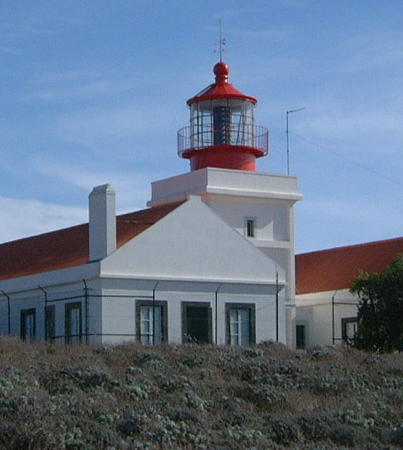
Ponta do Pargo Light, Madeira, March 2010
Flickr Creative Commons photo by Hansueli Krapf
Ilhas Selvagens Lighthouses
The Ilhas Selvagens (Savage Islands) are an archipelago of small islands located 280 km (175 mi) south of the Ilha da Madeira and 165 km (105 mi) north of the Canary Islands. The islands have no permanant population and have been a protected nature reserve since 1971. Rangers from the Madeira Nature Park staff an office on Selvagem Grande year round.

Selvagem Grande
1977. Active; focal plane 163 m (535 ft); white flash every 4 s. 10 m (33 ft) round cylindrical tower, flared at the top and bottom and colored with red and white horizontal bands. Trabas has Seiler's distant view from the sea, Wim Fields has a distant street view, and Bing has a satellite view. Located atop the Pico de Atalaia, on the west coast of Ilha Selvagem Grande, largest of the Ilhas Selvagens. Site and tower closed; special permission is needed to visit the island. Site manager: Reserva Natural das Ilhas Selvagens. ARLHS MAD-011; PT-668; Admiralty D2768; NGA 23776.

Ilhas Desertas Lighthouses
The Ilhas Desertas (Deserted Islands) are a string of three rocky islands southeast of the Ilha de Madeira. The islands are uninhabited and have been a protected nature reserve since 1990.

Ponta da Agulha (Ilhéu de Bugio) (2)
2003 (station established 1961). Active; focal plane 72 m (236 ft); white flash every 4 s. 8 m (26 ft) round fiberglass tower colored with red and white horizontal bands; 300 mm lens. No photo available but Google has a distant satellite view. The original lighthouse was a 14 m (46 ft) hexagonal concrete tower with lantern and gallery. In the 1990s this lighthouse was found to be in very poor condition, so in July 2003 it was imploded and replaced. Located near the southeastern tip of the Ilhéu de Bugio, southernmost of the three Ilhas Desertas. Site and tower closed; special permission is needed to visit the island. Site manager: Reserva Natural das Ilhas Desertas. ARLHS MAD-007; PT-665; Admiralty D2722; NGA 23752.
Ilhéu do Chão
1959. Active; focal plane 112 m (367 ft); two long (2 s) white flashes every 15 s. 14 m (46 ft) round cylindrical concrete tower with gallery, centered on a 1-story square concrete equipment room. Entire lighthouse painted white. Thanks to Stefan Leitner for contributing the photo at right. Trabas has Arndt's distant view from the sea and Google has a satellite view. Located at the northern tip of the Ilhas Desertas, about 25 km (15 mi) southeast of the São Laurenço lighthouse. Site and tower closed; special permission is needed to visit the island. Site manager: Reserva Natural das Ilhas Desertas. ARLHS MAD-001; PT-663; Admiralty D2720; NGA 23748.

Ilhéu do Chão Light, Ilhas Desertas
photo copyright C. Voigt and S. Leitner; used by permission

Ilha da Madeira Lighthouses
The island of Madeira is oriented east and west; it is about 130 km (80 mi) long and roughly 50 km (30 mi) wide.
São Lourenço
1870. Active; focal plane 103 m (338 ft); white flash every 5 s. 10 m (33 ft) octagonal cylindrical stone tower with lantern and gallery, rising from a 1-story stone keeper's complex; 400 mm acrylic lens. The building is unpainted with dark and light stone in vertical stripes; lantern painted red. The Direção de Faróis has a page for the lighthouse, Wikimedia has Bjørn Christian Tørrisen's photo (seen at right) and several distant views, Trabas has Arndt's photo, a Øyvind Andersen has a 2022 drone view, Lighthouse Explorer has a historic postcard view contributed by Michel Forand, Klaus Huelse has the same postcard view, and Google has a good satellite view. This lighthouse, the oldest in Madeira, stands atop a spectacular conical mountain (an extinct volcano). Located on the Ilhéu de São Lourenço, a small island off the eastern tip of the Ilha de Madeira. Accessible only by boat, and the island is a restricted natural area. Site and tower closed. Site manager: Reserva Natural da Ponta de São Laurenço. ARLHS MAD-004; PT-624; Admiralty D2726; NGA 23740.
São Roque (Machico)
Date unknown. Active; focal plane 12 m (39 ft); white or red light depending on direction, 2 s on, 3 s off. 7 m (23 ft) round cylindrical fiberglass tower, colored with red and white horizontal bands and mounted on a square 1-story white concrete equipment shelter. Trabas has Arndt's closeup photo, Lucília Lopes has a 2019 photo, and Bing has a satellite view. Located at the southern end of the harbor of Machico on the southeastern coast of Madeira. Site appears open but it's not clear if there is public access. Tower closed. PT-631; Admiralty D2728; NGA 23732.
* Funchal Breakwater
Date unknown. Active; focal plane 15 m (49 ft); red flash every 5 s. 6 m (20 ft) round concrete tower with gallery, painted with red and white horizontal bands. Charles Bash has a photo, Trabas has Hartmann's closeup photo, Ricardo Figueira has a street view, and Google has a satellite view. Funchal, on the south coast, is the capital and chief port of Madeira. Located at the end of the breakwater in Funchal. Accessible by walking the pier. Site open, tower closed. ARLHS MAD-013; PT-637; Admiralty D2738; NGA 23728.
São Lourenço Light
São Lourenço Light, Madeira, May 2013
Wikimedia Creative Commons photo by Bjørn Christian Tørrissen
* Câmara de Lobos (2)
1937 (station established 1920s?). Active; focal plane 23 m (75 ft); red light, 4 s on, 2 s off. 5 m (17 ft) square concrete equipment room with gallery; the light is displayed from a short mast on the roof. Building painted white; the mast has a red horizontal band. Trabas has Silvano's closeup photo, Charles Bash has posted a photo, Yang Meyer has another view, Fuchun Zhu has a 2021 photo, and Google has a street view and a satellite view. Located atop a vertical volcanic dike adjacent to the main pier at Câmara de Lobos, a village about 8 km (5 mi) west of Funchal on the south coast of the island. Site open, tower closed. ARLHS MAD-015; PT-650; Admiralty D2744; NGA 23724.
* Ribeira Brava
Date unknown (1920s?). Active; focal plane 34 m (112 ft); red flash every 5 s. 6 m (20 ft) square cylindrical tower; the light is shown from a projecting "bay window" enclosure near the top of the tower. Upper half of the lighthouse painted red, lower half white. Trabas has Silvano's closeup photo, Wikimedia has several good photos, Lightphotos.net has Mark Woodburry's 2013 photo, and Google has a street view and a satellite view. Located atop a sharp promontory west of the harbor but east of the downtown area of Ribeira Brava, about 16 km (10 mi) west of Funchal. Site status unknown, but the lighthouse is easily viewed from below. ARLHS MAD-014; PT-652; Admiralty D2746; NGA 23720.
** Ponta do Pargo
1922. Active; focal plane 312 m (1024 ft); three white flashes every 20 s. 14 m (46 ft) square masonry tower with lantern and gallery, rising from a U-shaped 1-story keeper's complex. 2nd order Fresnel lens. Building painted white with black trim; lantern painted red. Hansueli Krapf's photo appears at the top of this page, the Direção de Faróis has a page for the lighthouse, Trabas has Seger's photo, H.H. Schueller has posted a good closeup photo, Wikimedia has several good photos, Uwe Bücher has a street view, and Google has a fine satellite view. This is Madeira's best-known lighthouse by far, and also one of the highest lighthouses in the world. It commands a spectacular view westward over the Atlantic. Located on the western tip of the island; accessible by road. Site open, lighthouse open on Wednesday afternoons. . ARLHS MAD-005; PT-656; Admiralty D2752; NGA 23712.
[Ilhéu Mole (Porto Moniz)]
Date unknown. Active; focal plane 65 m (213 ft); flash every 5 s, white or red depending on direction. Light mounted on a 3 m (10 ft) hexagonal equipment building. Trabas has Arndt's photo, Wikimedia has a 2015 photo, Heiko Ostendorf has a 2022 photo, and Google has a satellite view. Located atop a giant rock off the harbor of Porto Moniz, and the northwestern corner of the Ilha de Madeira. Practically inaccessible. Site and tower closed. ARLHS MAD-010; PT-658; Admiralty D2754; NGA 23708.
* São Jorge
1959. Active; focal plane 271 m (889 ft); white light, 2 s on, 3 s off. 14 m (46 ft) round concrete tower with eight ribs, lantern and gallery, attached to a 1-story keeper's complex, Tower is unpainted concrete; lantern dome painted red. A photo by Heinrich Mück is at right, the Direção de Faróis has a page for the lighthouse, Trabas has Arndt's closeup photo, Hansueli Krapf has a distant view, V. Malho has a 2019 closeup, Sandro Figueira has a 2017 street view, and Google has a satellite view. This lighthouse shares its design with the Carapacho, Ponta da Garça, and Ponta do Cintrão lighthouses in the Azores. Located high atop the Ponta de São Jorge on the central north coast of the Ilha da Madeira. Site open, tower closed. . ARLHS MAD-008; PT-660; Admiralty D2755; NGA 23744.

São Jorge Light, Madeira, October 2018
Wikimedia Creative Commons photo by Hein.Mück

Ilha da Porto Santo Lighthouses
Porto Santo is an inhabited island, 11 km (7 mi) long and 6 km (3.5 mi) wide, about 50 km (30 mi) northeast of the Ilha de Madeira. A popular resort destination, the island is accessible by air or by ferry from Funchal, Ilha da Madeira.
Ilhéu de Ferro
1959. Active; focal plane 130 m (427 ft); white light, 3 s on, 12 s off. 14 m (46 ft) round cylindrical white concrete tower attached to a 1-story equipment shelter. Building painted white. Wikimedia has a photo and a distant view by Rui Branco, Trabas has Seiler's photo, several distant views are available, and Bing has a satellite view. Located on a small island off the southwestern tip of the Ilha de Porto Santo. Accessible only by boat. Site and tower closed. ARLHS MAD-002; PT-619; Admiralty D2762; NGA 23768.
Ilhéu de Cima
1900. Active; focal plane 124 m (407 ft); three white flashes every 15 s. 15 m (49 ft) square masonry tower with lantern and gallery, rising from a U-shaped 1-story keeper's house. Building painted white with gold trim; lantern painted brown. The Direção de Faróis has a page for the lighthouse including the photo at right, Trabas has a good photo by Seiler, a 2019 closeup photo is available, and Google has a good satellite view. The Ilhéu de Cima is a small (but high) island off the northeast coast of the Ilha de Porto Santo, helping to shelter Porto Santo's harbor of Vila Baleira. Accessible only by boat. Site open, tower closed. . ARLHS MAD-006; PT-610; Admiralty D2756; NGA 23756.
Porto Santo North Mole
Date unknown. Active; focal plane 13 m (43 ft); red flash every 4 s. 8 m (26 ft) round cylindrical concrete tower with gallery, painted with red and white horizontal bands. Lukáš Ševčík has a 2019 closeup photo, Don Amaro has a good photo, A.S. Figueiredo has a photo, Ricardo Gonçalves has a view from the sea, Trabas has Seiler's closeup photo, and Google has a satellite view. Located at the end of the north (really the west) mole of the new Vila Baleira harbor of Porto Santo. Site status unknown. PT-612; Admiralty D2757.2; NGA 23765.
Porto Santo South Mole
Date unknown. Active; focal plane 17 m (56 ft); green flash every 4 s. 9 m (30 ft) round cylindrical concrete tower with gallery, painted with dark green and white horizontal bands. Leo Ga has a 2019 closeup photo, Trabas has Seiler's closeup photo, and Google has a satellite view. Located at the end of the south mole of the new Vila Baleira harbor of Porto Santo. Site status unknown. PT-612.1; Admiralty D2757; NGA 23766.

Ilhéu de Cima Light, Porto Santo
Direção de Faróis photo

Information available on lost lighthouses:

Notable faux lighthouses:

Adjoining pages: North: Azores | Northeast: Southern Portugal | East: Southwestern Morocco

Return to the Lighthouse Directory index | Ratings key

Posted January 4, 2006. Checked and revised June 5, 2023. Lighthouses: 15. Site copyright 2023 Russ Rowlett and the University of North Carolina at Chapel Hill.