Lighthouses of Malaysia: West Malaysia West Coast

The nation of Malaysia is in two parts: Peninsular Malaysia (also called West Malaysia or Malaya) on the southern end of the Malay Peninsula and Malaysian Borneo (East Malaysia) on the island of Borneo roughly 700 km (450 mi) to the east. West Malaysia is the former Federation of Malaya, a union of 11 states placed under British protectorate in the late 1800s. Malaya became independent in 1957. In 1963 the British granted independence to Malaysia, a new country formed by uniting Malaya, Singapore, Sarawak, and Sabah (North Borneo). Singapore, a predominantly Chinese city just off the tip of Malay Peninsula, left the union in 1965 and has been independent since.

Malaya faces one of the world's most important waterways, often called simply The Straits. The Strait of Malacca opens westward to the Indian Ocean and separates Malaya from the Indonesian island of Sumatra. At its southeastern end the Strait of Malacca joins the Singapore Strait, which connects to the Natuna Sea, South China Sea and Pacific Ocean.

Malaysia is a federal constitutional monarchy consisting of thirteen states and three federal territories. This page describes lighthouses of the west coast of the Malay Peninsula, facing the Strait of Malacca and the Andaman Sea in the states of Perak, Penang, and Kedah.

Aids to navigation in Malaysia are the responsibility of the Marine Department (Jabatan Laut). Aids to navigation in the heavily-traveled strait are regulated by the Malacca Strait Council, a consortium of the maritime authorities of Singapore, Malaysia, and Indonesia.

The Malay term for a lighthouse is rumah api ("house of fire"); pulau is an island, terumbu is a reef, tanjung is a cape, bukit is a hill, sungai is a river, kuala is the mouth of a river, teluk is a bay, selat is a strait, and pelabuhan is a harbor.

ARLHS numbers are from the ARLHS World List of Lights. Admiralty numbers are from volume F of the Admiralty List of Lights & Fog Signals. U.S. NGA List numbers are from Publication 112.

General Sources
Online List of Lights - Malaysia - Malacca Strait
Photos posted by Greenfinder.asia, a navigational aids and maritime services company.
Online List of Lights - Malaysia
Photos by various photographers posted by Alexander Trabas. Most of the photos for this area are by Rainer Arndt.
Lighthouses in Malaysia
Photos by various photographers available from Wikimedia.
World of Lighthouses - Malaysia
Photos by various photographers available from Lightphotos.net.
Malaysian Lighthouses
Historic postcard views posted by Michel Forand.
Leuchttürme Asiens, Australiens, und Ozeaniens auf historischen Postkarten
Historic postcard views posted by Klaus Huelse.
GPSNauticalCharts
Navigational chart information for northwestern Malaysia.
Navionics Charts
Navigational chart for Malaysia.
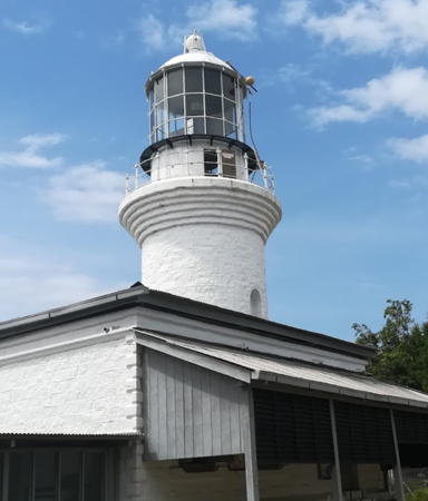
Muka Head Light,, Penang, January 2018
Google Maps photo by Peter Perháč

Perak Lighthouses

Bagan Datuk District Lighthouses
Kuala Bernam
Date unknown. Active; focal plane 14 m (46 ft); white flash every 4 s. 14 m (46 ft) concrete post light with gallery, mounted on a square concrete platform supported by piles. The upper portion of the tower is surrounded by a white vertically-slatted daymark. Savid Ooi has a distant view from shore, another distant view is available, and Bing has a distant satellite view. Located on the north side of the channel in the entrance to the Bernam River, which forms the boundary between the states of Selangor and Perak. Accessible only by boat. Site status unknown. Admiralty F1573.5; NGA 21884.
Pulau Jarak
Date unknown. Active; focal plane 162 m (531 ft); two white flashes every 15 s. Approx. 35 m (115 ft) square skeletal tower, painted with red and white horizontal bands, topped by a red tower. Faezy Elmy has a 2021 view from the sea, the light can be seen in Azrin Tajuddin's view of the island, and Bing has a satellite view. Next to the light tower is a round concrete communications tower. Located atop Pulau Jarak, a small, steep-sided island in the strait about 35 km (22 mi) southwest of Lumut. Accessible only by boat. Site status unknown. ARLHS WMA-017; Admiralty F1566; NGA 21898.
White Rock (Sembilan Islands) (2)
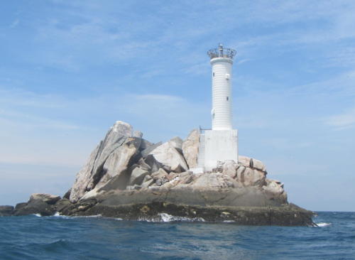
Date unknown. Active; focal plane 21 m (69 ft); two white flashes every 10 s. Approx. 15 m (49 ft) round cylindrical tower mounted on a square base. Entire lighthouse is white. A Greenfinder photo is at right, John Chai has a 2018 photo, and Bing has an indistinct satellite view. NGA lists a skeletal tower at this location. Located on a dangerous rock, the westernmost islet of the Sembilan Islands, about 25 km (15 mi) off Kampong Sungai Ular. Accessible only by boat. Site and tower closed. ARLHS WMA-020; Admiralty F1565; NGA 21900.

White Rock Light, Perak
Greenfinder.asia photo; used by permission

Manjung District (Lumut Area) Lighthouses
The Manjung District includes an area called Dinding that formed part of the British Crown Colony of Straits Settlements in 1867. In 1935 the Sultan of Perak persuaded the British to return Dinding to his control. The name of the district was changed from Dinding to Manjung in 1973. The area of Dinding includes the harbor of Lumut, now a major base for the Malaysian Navy and the site of a large shipbuilding yard.
[Pulau Tukun (Fairway Rock)]
Date unknown. Active; focal plane not listed; white flash every 8 s. Approx. 6 m (20 ft) post with gallery. Greenfinder has a photo and Google has an indistinct satellite view. Located atop an isolated islet about 25 km (15 mi) southwest of Lumut. Accessible only by boat. Site status unknown. Admiralty F1558.9; NGA 21914.
Pulau Katak (Lumut) (4?)
Date unknown (station established 1888). Active; focal plane 35 m (115 ft); white flash every 4 s. 11 m (36 ft) round concrete tower, painted white. Greenfinder has a photo and Google has a distant satellite view. The original light on a mast was replaced in 1919 by a tower with a focal plane height of 27 m (89 ft); the present tower replaced an 11 m (36 ft) brick tower. Located on a small island off a promontory at the southern entrance to Lumut. Site status unknown. ARLHS WMA-009; Admiralty F1558.5; NGA 21912.
Tanjung Terengganu (Pulau Pangkor)
Date unknown. Active; focal plane 10 m (33 ft); two white flashes every 4 s. 5 m (16 ft) round white concrete tower. Dhir Shah has a dark sunset photo and Google has a satellite view. Located on the southeast point of Pulau Pangkor, marking the west side of the southern entrance to Lumut. Accessible only by boat. Site open, tower closed. Admiralty F1560; NGA 21916.
Muroh
Date unknown. Active; focal plane 12 m (39 ft); continuous red light. 12 m (39 ft) white tower on a triangular pier or platform. No photo available but Google has a satellite view. Located midway on the east side of the southern entrance channel east of Pulau Pangkor. Accessible only by boat. Site open, tower closed. Admiralty F1560.5; NGA 21921.
Putih Common Range Rear
Date unknown. Active; focal plane 10 m (33 ft); white light, 2 s on, 2 s off. 10 m (33 ft) tower mounted on a triangular platform suppoirted by piles. No photo available but Google has a satellite view. The two ranges guide ships approaching Lumut from the north and northwest, respectively. Located just offshore south of the entrance to the harbor. Accessible only by boat. Site open, tower closed. Admiralty F1555; NGA 21932.
* Lumut Range Rear
2004 (?). Active; focal plane 12 m (39 ft); quick-flashing white light. 11 m (36 ft) square skeletal tower, mounted on a square equipment building. Amir Gan has a closeup photo, a 2020 drone view is available and Google has a satellite view. This is the entrance range for the Marjung (Dinding) River at Lumut. Google has a street view and Greenfinder has a photo of the front light, a similar 9 m (30 ft) beacon offshore in the harbor. Located next to the Orient Star Resort on the south shore of the river in Lumut. Site appears open, tower closed. Admiralty F1562.1; NGA 21965.5.

Pulau Katak Light, Lumut
Greenfinder.asia photo; used by permission
Bilik (South Entrance) Range Rear
Date unknown. Active; focal plane 16.5 m (53 ft); white flash every 3 s. 16.5 m pyramidal white tower mounted on a square platform supported by robust piles. Greenfinder has a photo and Google has a distant sea view, and a distant satellite view. The range guides vessels approaching Lumut from the south in the channel between Pangkal Island and the mainland. Located about 1 km (0.6 mi) east of Tanjung Hantu. Accessible only by boat. Site open, tower closed. Admiralty F1559.1; NGA 21948.
* Tanjung Hantu
Date unknown. Active; focal plane 30 m (98 ft); white flash every 5 s. 6 m (20 ft) round white concrete tower. Greenfinder has a closeup photo, Ahmad Hasyim has a 2022 photo, Ibrahim Bin Haji Ngah Ahmad has a view from the sea, and Google has a sea view and a satellite view. Located on a prominent cape about 20 km (13 mi) northwest of Lumut. Site open, tower closed. . Admiralty F1554; NGA 21924.
[Pulau Talang]
Date unknown. Active; focal plane 21 m (69 ft); white flash every 7 s. Approx. 7 m (23 ft) white post with gallery. Sean Tan has a photo but trees hide the light in Google's satellite view. Located on the northern tip of Pulau Talang, about 30 km (19 mi) north of Lumut. Accessible only by boat. Site open, tower closed. Admiralty F1553.2; NGA 21968.
Kuala Beruas (2?)
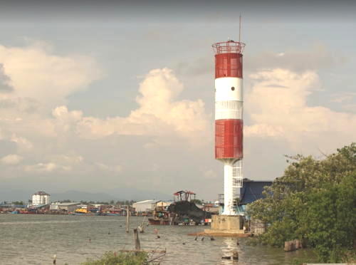
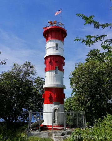
Date unknown. Active; focal plane 22 m (72 ft); two white flashes every 10 s. 20 m (66 ft) post; the upper 2/3 of the tower is surrounded by a round cylindrical daymark colored with red and white horizontal bands. Heok Meng Kok has a photo (also seen at right) and Google has a street view and an indistinct satellite view. Located at a port entrance about 30 km (19 mi) north of Lumut. Site probably open, tower closed. Admiralty F1552.5; NGA 21970.

Kuala Beruas Light, Perak, April 2017
Google Maps photo by Heok Meng Kok

Penang Lighthouses

Penang (also spelled Pinang) is a large island (293 km2 or 113 mi2) off the northwestern coast of Malaya; together with the adjoining mainland city of Seberang Perai it forms the state also called Penang. Ceded to Britain by the Sultan of Kedah in 1786, the island was the first British outpost in Malaysia. From 1826 to World War II the island was part of the Straits Settlements colony. It is accessible from the mainland by air, by a bridge, or by ferry from Butterworth on the mainland to George Town on the island. A second bridge, the longest in Southeast Asia, opened in 2014.

Seberang Perai City Lighthouses
Sungai Perai
Date unknown. Active; focal plane 15 m (49 ft); white, red or green light depending on direction, 2 s on, 2 s off. 14 m (46 ft) round cylindrical concrete tower painted with red and white horizontal bands. A photo is available (tower to the left of the three trucks) but the tower is not conspicuous in Google's satellite view. This is a leading light for ships entering the Perai River docks opposite Penang Island. Located in an industrial area on the south side of the river just west of the Railway Swing Bridge. Site and tower closed. Admiralty F1519.5; NGA 22034.

Pulau Penang City: Penang Island and Penang Harbor Lighthouses
Pulau Rimau
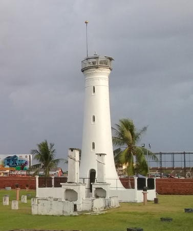
1885. Active; focal plane 39 m (128 ft); two white flashes every 10 s. 17 m (56 ft) round cylindrical cast iron tower with lantern and gallery, attached to a 1-story keeper's house. Lighthouse painted white. A Marine Department photo is at right, a closeup photo is available,Meorfariz Johor has a 2021 photo, Forand has a historic postcard view, and Google has a satellite view. This lighthouse marks the beginning of the approach from the south to George Town, the principal town of Penang island and the capital of Pulau Pinang state. Located on a small island off the southeastern tip of Penang Island. Accessible only by boat. Site open, tower closed. ARLHS WMA-011; Admiralty F1540; NGA 21992.
Owen Beacon (2?)
Date unknown. Active; focal plane 14 m (46 ft); green flash every 5 s. 14 m (46 ft) round concrete tower painted white and mounted on a platform supported by piles. Greenfinder has a closeup photo, Google has a very distant street view from the Penang Bridge, and Bing has a satellite view. NGA lists a "green pile beacon." Located in the channel between the island and the mainland, about 1800 m (1.1 mi) south of the Penang Bridge. Accessible only by boat. Site open, tower closed. Admiralty F1529; NGA 22016.
Great Kra Flat Range Rear
Date unknown. Active; focal plane 16 m (52 ft); quick-flashing white light. 16 m (46 ft) round white concrete tower mounted on a platform supported by piles. Greenfinder has a closeup photo, Google has a very distant street view from the Penang Bridge, and Bing has a satellite view. The range guides vessels northbound into the harbor, avoiding the extensive shallow area known as the Great Kra Flat. The front light is on a smiliar tower 9 m (30 ft) tall. Located in the channel between the island and the mainland, about 1200 m (3/4 mi) south of the Penang Bridge. Accessible only by boat. Site open, tower closed. Admiralty F1532.1; NGA 22012.
Pulau Rimau Light
Pulau Rimau Light, Penang
Malaysian Marine Department photo
* Fort Cornwallis (Fort Point, Penang) (1)
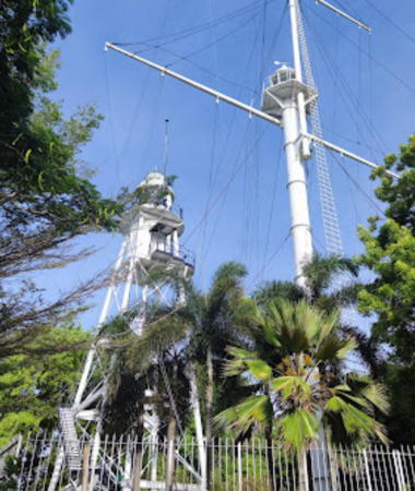
1882. Inactive since 1914. 21 m (69 ft) cast iron post with lantern and hexagonal gallery, painted white. Attached to the tower is a tall mast similar to a ship's mast, with two spars. A 2022 photo is at right, Syeefa Jay's August 2007 photo and one of Wikimedia's photos show both lighthouses, Mathieu Castel has another good photo, Google has a street view, and Forand has a historic postcard view. The tower remained in service as a signal tower after the light was deactivated. Both Fort Cornwallis lighthouses were restored in 2005-06 by the Penang State Tourism Development Committee. Located on a promontory in George Town, the capital of Penang, on the northeast side of the island. Site open, tower closed.
**** Fort Cornwallis (Fort Point, Penang) (2)
1914 (station established 1882). Active; focal plane 27 m (89 ft); red flash every 2 s. 21 m (69 ft) square pyramidal cast iron skeletal tower with lantern, gallery, and enclosed watch room, painted white. Adjacent to the lighthouse is the tall signal mast carrying the original light (previous entry). A 2022 photo is at right, Trabas has Arndt's photo, Lightphotos.net has a photo, a 2020 photo is available, Forand has a historic postcard photo, Huelse has a distant postcard view, and Google has a street view and a satellite view. Prefabricated in England, this lighthouse is a rare survivor of its type. It stands within the walls of Fort Cornwallis, a classic star-shaped late 18th century fort that was the first British outpost in Malaya. A restoration project during 2006 made it possible to open the lighthouse to visitors; a small museum has also been built. Located on a promontory in George Town, the capital of Penang, at the northeastern corner of the island. Site open, tower open but we do not know the schedule. . ARLHS WMA-004; Admiralty F1494; NGA 22056.
Pulau Tikus (2?)
Date unknown. Active; focal plane 15 m (49 ft); white flash every 3 s. 7 m (23 ft) post with a large square gallery, mounted on a small 1-story equipment room. Entire lighthouse painted white. There is a building adjacent to the light, as well as a grave (probably of a former keeper). Lou Meylemans has a closeup photo, Guo An Dennis Tan also has a closeup, Trabas has Arndt's view from the sea, and Google has a satellite view. Pulau Tikus (Rat Island) is a small island just off the northeast coast of Penang Island. Accessible only by boat. Site open, tower closed. ARLHS WMA-031; Admiralty F1490; NGA 22092.

Fort Cornwallis Lights, Penang, June 2022
Google Maps photo by Darric P'ng
Muka Head
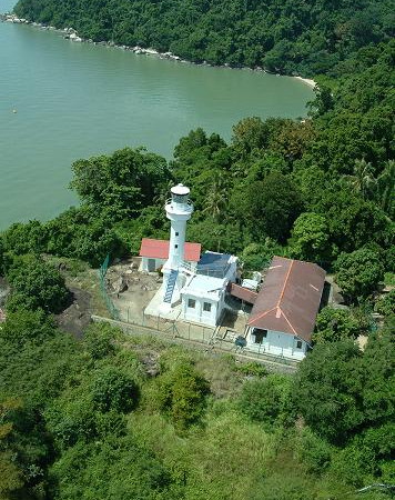
1883. Active; focal plane 242 m (794 ft); white flash every 10 s. 14 m (46 ft) round cylindrical granite tower with lantern and gallery, attached to a 1-story keeper's house. Lighthouse painted white. This is a staffed station. Peter Perhac's 2018 photo appears at the top of this page, Greenfinder has a similar closeup photo, Horng Yih Wong has a 2008 photo, Trabas has Arndt's distant view, Forand has a historic postcard view, and Google has a street view and a satellite view. This lighthouse is the landfall light for Penang for ships arriving from the Indian Ocean. Located atop a high promontory at the northwestern tip of the island. There is no road access to this station; an early 2009 visitor reports that the lighthouse is accessible by a 2-hour hike (bring plenty of water) from the entrance to Penang National Park at Teluk Bahang. Site open, tower open by arrangement with the keeper. Site manager: Penang National Park. ARLHS WMA-006; Admiralty F1486; NGA 22088.

Kedah Lighthouses

Pulau Perak Lighthouse
Pulau Perak
Date unknown. Active; focal plane 128 m (420 ft); two white flashes every 10 s. Approx. 18 m (60 ft) round concrete tower painted with red and white horizontal bands. A Greenfinder photo is at right and Google has a satellite view of the station. The light was formerly painted with black and white bands as seen in an older photo; the light was repainted red and white sometime after 2017. Pulau Perak is a small island about 145 km (90 mi) west northwest of Penang in the middle of the northern entrance to the Strait of Malacca. The island is the westernmost point of Malaysia. Located at the highest point of the island. Accessible only by boat. Site and tower closed. ARLHS IDO-239; Admiralty F1476.1; NGA 22367.

Langkawi District Lighthouses
Most of the lighthouses of Kedah are in the Langkawi Islands, an archipelago of 99 islands in the Andaman Sea roughly 30 km (19 mi) off the mainland just south of the Thai border. The islands are a popular destination for tourists and vacationers.

Pulau Enggang (2)
Date unknown (2009?). Active; focal plane 60 m (197 ft); white flash every 8 s. 11 m (36 ft) round cylindrical concrete block tower, painted white. Greenfinder has a photo, a February 2009 photo (no longer online) showed scaffolding around the lighthouse, and Google has an indistinct satellite view. This new lighthouse replaced a skeletal tower. The light serves as a landfall light for vessels arriving in the islands from the mainland. Located on a small island off the east coast of Pulau Tuba, on the southeast side of the Langkawi archipelago. Accessible only by boat. Site status unknown. Admiralty F1476; NGA 22124.
Pulau Kedera (Pulau Jerkum Besar) (2)
Date unknown. Active; focal plane 79 m (259 ft); white flash every 5 s. Approx. 15 m (49 ft) round barbell-shaped white fiberglass tower mounted on a platform supported by piles. Greenfinder has a photo and Google has a satellite view. Trabas has Arndt's photo of the earlier light, a round concrete tower. Located atop a small island in the bay south of Pulau Langkawi, the largest of the Langkawi Islands. Accessible only by boat. Site status unknown. ARLHS WMA-018; Admiralty F1477.3; NGA 22123.
* Teluk Telaga
Date unknown. Active (unofficial, charted by Navionics as a landmark); focal plane about 24 m (79 ft); continuous (?) white light. 22 m (72 ft) 12-sided faux-rubblestone tower with lantern and gallery. A photo is available, there's a photo of the lighthouse in action, and Google has a street view and a satellite view. Located at the entrance to a resort area at Telaga harbor, near the west end of Pulau Langkawi. Site open, tower closed. Not listed by the Admiralty.


Pulau Perak Light, Strait of Malacca, ca. 2018
Greenfinder.asia photo; used by permission

Tanjung Chinchin
Date unknown. Active; focal plane 11 m (36 ft); three white flashes every 15 s. 11 m (36 ft) round fiberglass tower mounted on a square concrete pier. Entire lighthouse is white. Ai Zizul has a 2021 photo and Google has a satellite view. Located just off the northwestern tip of Pulau Langkawi. Accessible only by boat. Site status unknown. Admiralty F1470; NGA 22132.
Pulau Dangli
Date unknown. Active; focal plane 86 m (282 ft); white flash every 10 s. Approx. 18 m (59 ft) skeletal tower mounted on a square 1-story concrete base. Greenfinder has a photo and Google has a sea view and an indistinct satellite view. Located atop a small island off the north coast of Pulau Langkawi. Accessible only by boat. Site status unknown. Admiralty F1471; NGA 22134.
Pulau Sigal
Date unknown. Active; focal plane 28 m (92 ft); white flash every 5 s. Approx. 7 m (23 ft) post mounted on or adjacent to a 1-story equipment building. Entire lighthouse is white. Ikhwan Iwan has a closeup photo and Google has a satellite view. Located on a small island off the north point of Pulau Timun and across a narrow channel from the southeastern point of Pulau Langkawi. Accessible only by boat. Site status unknown. Admiralty F1476.3; NGA 22130.

Kota Setar District Lighthouses
* Sungai Sala (Sungai Tabangau Entrance) (2?)
Date unknown. Active; focal plane 9 m (30 ft); white flash every 4 s. 9 m (30 ft) square white concrete skeletal tower. Greenfinder has a photo, Ian Ramli has a distant view, and Google has a street view and an indistinct satellite view. NGA lists a "concrete mast." Located at Kampong Sala, a village about 15 km (9 mi) south of Kuala Kedah. Site open, tower closed. Admiralty F1479; NGA 22112.
* Kuala Kedah (Kedah River, Sungai Kedah)
1904. Active; focal plane 15 m (49 ft); two white flashes every 10 s. Approx. 14 m (46 ft) tapered round masonry tower, painted white. Lantern removed. Sujinno Dee has a photo (also seen at right), Greenfinder has a photo, another photo is available, Eff Wye has a street view, and Google has a satellite view. Located on the north side of the entrance to the estuary and harbor of Kuala Kedah, a town in the northwestern corner of Malaysia. There should be a view from ferries leaving Kuala Kedah for Langkawi. Site open, tower closed. ARLHS WMA-014; Admiralty F1478; NGA 22116.

Information available on lost lighthouses:

  • Perak River (1891-?). A screwpile lighthouse was built on a shoal 8 km (5 mi) north of the entrance. There is no light at this location today.

Sungai Kedah Light, Kuala Kedah, March 2018
ex-Google Plus photo by Sujinno Dee

Notable faux lighthouses:

  • Tanjung Malai, an approx. 21 m (69 ft) octagonal white concrete tower with two galleries, is located at the cruise ship terminal at the southwestern tip of Pulau Langkawi. It is not a recognized aid to navigation. Haizul Adri has a 2020 photo and Google has a satellite view and a sea view.

Adjoining pages: North: Southern Thailand: West Coast | South: West Malaysia South Coast | West: Eastern Sumatra

Return to the Lighthouse Directory index | Ratings key

Posted March 12, 2006. Checked and revised May 26, 2024. Lighthouses: 28. Site copyright 2024 Russ Rowlett and the University of North Carolina at Chapel Hill.