Lighthouses of Malaysia: Southeast West Malayasia

The nation of Malaysia is in two parts: Peninsular Malaysia (also called West Malaysia or Malaya) on the southern end of the Malay Peninsula and Malaysian Borneo (East Malaysia) on the island of Borneo roughly 700 km (450 mi) to the east. West Malaysia is the former Federation of Malaya, a union of 11 states placed under British protectorate in the late 1800s. The Federation of Malaya became independent in 1957 and in 1963 the federation became Malaysia, a new country formed by uniting Malaya, Singapore, Sarawak, and Sabah (North Borneo). Singapore, a predominantly Chinese city just off the tip of the Malay Peninsula, left the union in 1965 and has been independent since.

West Malaysia faces one of the world's most important waterways, often called simply The Straits. The Strait of Malacca opens westward to the Indian Ocean and separates Malaya from the Indonesian island of Sumatra. At its southeastern end, the Strait of Malacca joins the Singapore Strait, which connects to the South China Sea and Pacific Ocean.

Malaysia is a federal constitutional monarchy consisting of thirteen states and three federal territories. This page describes lighthouses of the southeast coast of West Malaysia, facing the South China Sea in the states of Pahang and Johor. Because international shipping lanes are far offshore in the South China Sea no major lighthouses were built on Malaya's east coast during the British Colonial period; with few exceptions the lights on this page are of relatively modern origin.

The Malay term for a lighthouse is rumah api ("house of fire"); pulau is an island, terumbu is a reef, tanjung is a cape, bukit is a hill, sungai is a river, kuala is the mouth of a river, teluk is a bay, selat is a strait, and pelabuhan is a harbor.

Aids to navigation in Malaysia are the responsibility of the Marine Department (Jabatan Laut).

ARLHS numbers are from the ARLHS World List of Lights. Admiralty numbers are from volume F of the Admiralty List of Lights & Fog Signals. U.S. NGA List numbers are from Publication 112.

General Sources
Lighthouses of Malaysia
Photos posted by Greenfinder.asia, a navigational aids and maritime services company.
Online List of Lights - Malaysia
Photos by various photographers posted by Alexander Trabas.
Lighthouses in Malaysia
Photos by various photographers available from Wikimedia.
Malaysian Lighthouses
Historic postcard views posted by Michel Forand.
Malaysia List of Lights 2020
Microsoft Excel spreadsheet with data for all the officiaal lights.
Leuchttürme Asiens, Australiens, und Ozeaniens auf historischen Postkarten
Historic postcard views posted by Klaus Huelse.
GPSNauticalCharts
Navigational chart for Malaysia.
Navionics Charts
Navigational chart for Malaysia.

Tanjung Gelang Light, Balok, June 2012
Google Maps photo by 9M2RDX Rizal

Pahang Lighthouses

Pahang is a state and heritary sultanate that includes the central east coast of West Malaysia. With a population of about 1.7 million, the state occupies the basin of the Pahang River. Kuantan is the state capital.

Kuantan District Lighthouses
Kuantan Port NDWT Sector
Date unknown. Active; focal plane 30 m (98 ft); white, red or green light, depending on direction, occulting once every 5 s. 30 m (98 ft) white skeletal tower carrying a daymark painted white with a red vertical stripe and mounted on a square platform supported by piles. Google has a satellite view and a distant street view from shore. Founded in 1974, Kuantan Port is a modern harbor developed just north of Tanjung Gelang; it includes the South China Sea base of the Malaysian Navy. This leading light guides ships into the NDWT port on the north side of the complex. Located about 800 m (1/2 mi) offshore just north of the Kuantan breakwaters. Accessible only by boat. Site and tower closed. Admiralty F2858.8; NGA 21061.
Kuantan Port Range Front
Date unknown. Active; focal plane 13 m (43 ft); quick-flashing green light. 10 m (33 ft) white square skeletal tower. Greenfinder has a photo and Google has a satellite view. Located at the foot of the north breakwater of the harbor. Site and tower closed. Site manager: Kuantan Port Authority. Admiralty F2858; NGA 21056.
Kuantan Port Range Rear
Date unknown. Active; focal plane 34 m (115 ft); green light occulting once every 5 s. 30 m (98 ft) triangular cylindrical steel skeletal tower, painted white. Greenfinder has a photo and Google has a street view and a satellite view. Located in a tank farm on the east side of the harbor. Site and tower closed. Site manager: Kuantan Port Authority. Admiralty F2858.1; NGA 21060.
Kuantan Port Middle Breakwater
Date unknown. Active; focal plane 12 m (39 ft); yellow flash every 3 s. 10 m (33 ft) round concrete tower painted yellow. No photo available but Google has a satellite view. NGA calls this the North Breakwater. Located on a main breakwater of Kuantan Port (it appears that this breakwater separates the commercial and naval harbors). Site and tower closed. Admiralty F2858.3; NGA 21064.
Tanjung Gelang
1977. Active; focal plane 85 m (279 ft); three white flashes every 10 s. 7 m (23 ft) round cylindrical masonry tower with lantern and gallery, attached to a small 1-story equipment room. Lighthouse painted white. A closeup (bottom right on the page) is in fact the original of the Google Maps photo at the top of this page, amateur radio operators have posted two photos (1/3 to 1/2 the way down the page), an aerial view was posted originally by the Marine Department, and Google has a satellite view. Located on a prominent cape at Balok, about 30 km (19 mi) north of Pahang in Pahang state. Accessible by road, but the lighthouse is probably on the restricted naval base. Site and tower closed. ARLHS WMA-024; Admiralty F2857; NGA 21052.
* Tanjung Tembeling (2)
Date unknown. Active; focal plane 69 m (226 ft); two white flashes every 10 s. 6 m (20 ft) square skeltal tower; Gerard van den Bosch has a 2023 photo and Google has a satellite view. Located on the hillside above a popular resort on the cape, east of Kuantan. Site open, tower closed. Site manager: Kuantan Tembeling Resort. Admiralty F2847; NGA 21076.
Sungai Kuantan (Bukit Pelinding) (Range Rear?)
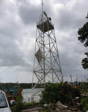
Date unknown. Active; focal plane about 13 m (43 ft); two green flashes every 5 s. 12 m (39 ft) square skeletal tower carrying a diamond-shaped daymark painted red with a black vertical stripe. Greenfinder has a photo (also seen at right), the light is at the right edge of a photo of the harbor, and Google has a street view and a satellite view. This light is listed as a rear light and the Malaysian light list notes it is 46 m (150 ft) "from front," but there is apparently no front light; there may be an unlit daybeacon. Located on the north side of the Kuantan River just west of the Galing River bridge. Site status unknown. Admiralty F2848.1; NGA 21084.

Sungai Kuantan Range Rear Light, Kuantan
Greenfinder.asia photo

Pekan District Lighthouses
* [Kuala Pahang]
Date unknown. Active; focal plane 12 m (39 ft); white flash every 7 s. 12 m (39 ft) white mast. Greenfinder has a photo and Google has a street view; the post is barely visible in Google's satellite view. Located on the north side of the entrance to the Pahang River. Site open, tower closed. Admiralty F2845; NGA 21088.
Pulau Berhala (Varella)
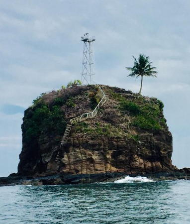
Date unknown. Active; focal plane 30 m (98 ft); two white flashes every 5 s. 12 m (39 ft) square white skeletal tower. Greenfinder has a photo (also seen at right) and fishermen out of Pekan have several photos (2/3 the way down the page) but the islet is not seen in Bing's satellite view. The lighthouse is perched improbably atop a vegetated islet about 25 km (15 mi) southeast of Kuala Pekan. Looks inaccessible. Admiralty F2842; NGA 21122.
Telaga Papan (Nenasi) (2)
Date unknown. Active; focal plane about 16 m (52 ft); white flash every 3 s. Approx. 14 m (46 ft) square white skeletal tower. Lee Cheah Eu has a fuzzy street view from the beach and Google has an indistinct satellite view. NGA lists a wood skeletal tower. Located just off the beach in Nenasi. Site open, tower closed. Admiralty F2840; NGA 21124.

Rompin District Lighthouses
Tanjung Lanting (Pulau Tioman)
Date unknown. Active; focal plane 20 m (66 ft); three white flashes every 15 s. 20 m (66 ft) concrete post with gallery. Entire structure is white. Greenfinder has a photo and Google has a satellite view. Tioman Island is a popular vacation destination 32 km (20 mi) off the coast of Pahang. 39 km (24 mi) long and 12 km (7.5 mi wide), the mountainous island is known for its scenic beauty and its coral reefs. Located in the surf at the southeastern tip of Pulau Tioman. Accessible only by boat. Site open, tower closed. Admiralty F2836.8; NGA 21136.
Tanjung Penuba
Date unknown. Active; focal plane 18 m (59 ft); two white flashes every 5 s. 16 m (52 ft) concrete post with gallery, mounted on a square concrete pier. Google has a sea view and Google has a satellite view. Located on a promontory on the northwest coast of Pulau Tioman. Accessible only by boat. Site open, tower closed. Admiralty F2836.9; NGA 21134.
Tokong Bahara
Date unknown. Active; focal plane 30 m (98 ft); two white flashes every 5 s. 14 m (46 ft) concrete post light with two galleries, mounted on a large square concrete pier. A 2022 photo is available, Daniel Kwok has a photo misidentified as "Berhala," and Google has a fuzzy satellite view. Located on a rocky reef about 15 km (9 mi) southwest of Pulau Tioman. Accessible only by boat, but there may be a view from ferries between Mersing and Tioman. Site open, tower closed. Admiralty F2836.7; NGA 21138.

Pulau Berhala Light, Pahang
Greenfinder.asia photo

Eastern Johor Lighthouses

Johor state occupies the southern tip of the Malay Peninsula, separated from Singapore by the narrow Johor Strait. The state has an east coast on the South China Sea and a west coast on the Strait of Malacca. Lighthouses of the west coast are described on the West Malayasia South Coast page. Prior to the arrival of the British the Sultanate of Johor controlled a large area of the Malay Peninsula as well as the Riau Islands and portions of Sumatra in what is now Indonesia.

Mersing District Lighthouses
Padang Endau (Inner)
Date unknown. Active; focal plane 12 m (39 ft); red flash every 3 s. 12 m (39 ft) white concrete post on a square platform supported by piles. The tower also carries a red square daymark. No photo available but Google has a distant street view and a fuzzy satellite view. Located about 1.5 km (1 mi) east of the mouth of the Endau River, which forms the border between Padang and Johor. Accessible only by boat. Site open, tower closed. Admiralty F2837; NGA 21140.
Padang Endau Outer
Date unknown. Active; focal plane 12 m (39 ft); quick-flashing white light. 12 m (39 ft) white concrete post on a square platform supported by piles. The tower also carries a white square daymark and a black vertical stripe. A view from the beach is available and Google has a distant satellite view. Located off a point of land about 1.6 km (1 mi) east of the inner light. Accessible only by boat. Site open, tower closed. Admiralty F2837.2; NGA 21144.
Pulau Achi (Anchi, Mertang Barat)
2002. Active; focal plane 57 m (187 ft); two white flashes every 10 s. Approx. 16 m (52 ft) square skeletal tower with gallery, painted white; the upper portion of the tower is enclosed by a white slatted daymark. A long stairway leads to the lighthouse. Greenfinder has a closeup photo, another closeup photo is available, Marine Traffic has a view from the sea and Google has a satellite view. Located on a small island about 16 km (10 mi) east of Rompin. Accessible only by boat. Site status unknown. Admiralty F2836.3; NGA 21148.
Pulau Harimau (Tiger Island)
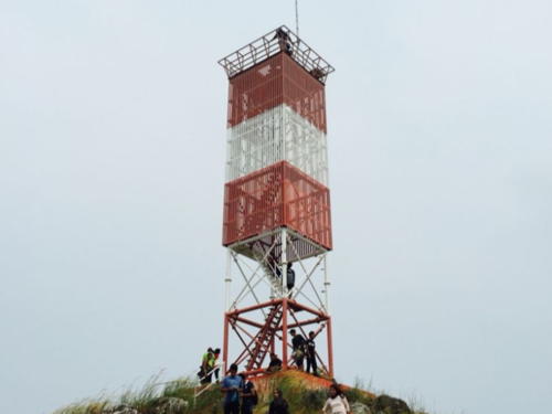
Date unknown. Active; focal plane 97 m (318 ft); white flash every 5 s. Approx. 17 m (56 ft) square cylindrical skeletal tower, covered with a slatted daymark painted with red and white horizontal bands. A long stairway leads to the lighthouse. A photo is at right, Venkat Vijay Kumar Pentapati has a view from the sea, Greenfinder has a closeup, and Google has a satellite view. Located on the northernmost of a group of small islands northeast of Mersing. Accessible only by boat. Site status unknown. Admiralty F2836.1; NGA 21150.

Pulau Harimau Light, Mersing, September 2020
unattributed Google Maps photo posted by Mohamad Amirul Syafiq
Pulau Setindan (Stindan)
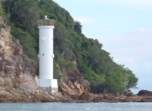
Date unknown. Active; focal plane 9 m (30 ft); white flash every 11 s. 8 m (26 ft) round cylindrical concrete tower standing on a square concrete base. Entire lighthouse is white. Greenfinder has a photo and Google has an indistinct satellite view. Located at the southeastern tip of Setindan, an island in the entrance to the harbor of Mersing. Accessible only by boat. Site open, tower closed. Admiralty F2836; NGA 21164.
Batu Sakit Mata
Date unknown. Active; focal plane 13 m (43 ft); white flash every 3 s. 13 m (43 ft) white concrete tower. No photo available and the light is not seen in Google's satellite view. Located on a reef about 5 km (3 mi) east of Pulau Babi Besar. Accessible only by boat. Site open, tower closed. Admiralty F2835.5; NGA 21165.
Batu Tikus
Date unknown. Active; focal plane 12 m (39 ft); two white flashes every 20 s. 12 m (39 ft) white concrete mast with a large square gallery. Greenfinder has a photo but the light is not seen in Google's satellite view. Located on a reef about 5 km (3 mi) southeast of Batu Sakit Mata. Accessible only by boat. Site open, tower closed. Admiralty F2835.3; NGA 21166.
Pulau Lang
Date unknown. Active; focal plane 55 m (180 ft); white flash every 5 s. Approx. 16 m (52 ft) square cylindrical skeletal tower. Greenfinder has a closeup photo and Google has a satellite view. Located on a small island off the west coast of Pulau Aur, an island 65 km (40 mi) east of Mersing. Accessible only by boat. Site status unknown. Admiralty F2835; NGA 21167.
Batuan Merau
Date unknown. Active; focal plane 15 m (49 ft); white flash every 5 s. 15 m (49 ft) concrete tower on a platform supporyed by piles. No photo available and the light is not shown in Bing's satellite view. Located ona reef northeast of Tanjung Tenggaroh. Accessible only by boat. Site open, tower closed. Admiralty F2832.5; NGA 21167.5.
Pulau Setindan Light
Pulau Setindan Light, Mersing, June 2010
ex-Panoramio photo copyright husswahab; used by permission
Tanjung Tenggaroh
Date unknown. Active; focal plane unknown; white flash every 10 s. NGA provides no description of this lighthouse and no photo is available but Google has an indistinct satellite view. Located on a prominent cape about 30 km (19 mi) southeast of Mersing. Site status unknown. Admiralty F2832; NGA 21168.
Tanjung Leman North
Date unknown. Active; focal plane about 9 m (30 ft); green flash every 3 s. Approx. 7 m (23 ft) pyramidal green concrete tower. Thomas Twyford has a distant view across the harbor, Google has a distant street view, and Bing has a distant satellite view. NGA lists these breakwater lights with a focal plane of only 5 m (16 ft); they seem taller than that. Located at theend of the breakwater of the Tanjung Leman harbor. Accessible only by boat. Site open, tower closed. Admiralty F2831; NGA 21169.5.
Tanjung Leman South
Date unknown. Active; focal plane about 9 m (30 ft); red flash every 3 s. Approx. 7 m (23 ft) pyramidal red concrete tower. No photo available but Google has a distant satellite view. Located on the south side of the entrance to the Tanjung Leman harbor. Accessible only by boat. Site open, tower closed. Admiralty F2830; NGA 21169.

Kota Tinggi District (Singapore Strait) Lighthouses
Tompok Utara (Light TU) (2)
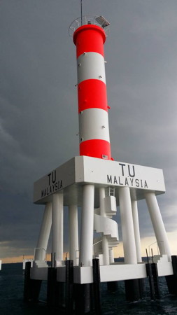
2014 (station establishment date unknown). Active; focal plane 27 m (89 ft); three white flashes every 15 s. 27 m (89 ft) round fiberglass tower mounted on a square platform supported by piles. Lighthouse colored with red and white horizontal bands. The photo at right is from Greenfinder's Facebook page, Greenfinder also has an aerial view, and Trabas has Rainer Arndt's photo, but the light is not seen in Google's satellite view. The name Tompok Utara means "Northeast" and this light stands on the Ramunia Shoal marking the northeastern beginning of the passage through the Singapore Strait for ships arriving from the South China Sea. It is somewhat similar in design to the Selatan lighthouses (see the West Malayasia South Coast page) at the other end of the Straits. Located on a shoal about 13 km (8 mi) east of Kampong Punggai. Accessible only by boat. Site open, tower closed. Admiralty F1821; NGA 21186.
Middle Rocks
Date unknown. Active (?) (charted as a landmark by Navionics); focal plane about 28 m (92 ft); yellow flash every 5 s. Approx. 25 m (82 ft) round cylindrical tower painted with red and white horizontal bands and centered on a round 4-story building. A 2018 closeup photo is available, Izzuardi Sulong has a 2019 photo, and Google has a fuzzy satellite view of the station. This light station is connected to a complicated and lengthy dispute between Malaysia and Singapore concerning ownership of the Pedra Blanca reef, site of Singapore's historic Horsburgh lighthouse (see the Singapore page for discussion). In 2008 the International Court of Justice awarded ownership of Pedra Blanca to Singapore but also awarded ownership of Middle Ricks to Malaysia. Located about 800 m (1/2 mi) south of Pedra Blanca. Accessible only by boat. Site and tower closed. Admiralty F1818.
Tompok Utara Light
Tompok Utara Light, September 2014
Greenfinder photo courtesy of Ezmil Sahrani
Pulau Mungging (2)
Date unknown. Active; focal plane 25 m (82 ft); white flash every 3 s. 12 m (39 ft) round white concrete tower. Greenfinder has the photo at right, Roger Ribut has a distant 2021 view and Google has a satellite view. This lighthouse marks the extreme southeastern tip of the Malay Peninsula and stands at the north side of the eastern entrance to Singapore Strait. The Marine Department has a small photo of the original lighthouse, a square skeletal tower with enclosed upper section. Located just offshore, about 12 km (7.5 mi) south of Kampong Punggai. Accessible only by boat. Site open, tower closed. ARLHS WMA-025; Admiralty F1822; NGA 21180.
Disl East Leading
Date unknown. Active; focal plane 19.5 m (70 ft); continuous red,white or green light, depending on direction. Approx. 20 m (66 ft) white tower. No photo available but Google has a satellite view. Located on the pier at the Pengarang Terminal. Site and tower closed. Admiralty F1736.96; NGA 21182.2.
Disl West Leading
Date unknown. Active; focal plane 19.5 m (70 ft); continuous red,white or green light, depending on direction. Approx. 20 m (66 ft) white tower. No photo available but Google has a satellite view. Located near the end of the pier at the Pengarang Terminal. Site and tower closed. Admiralty F1736.975; NGA 21182.4.
Tanjung Kapal Range Front
Date unknown. Active; focal plane about 23 m (85 ft); continuous red light. Approx. 20 m (66 ft) robust steel mast. No photo available but Google has a street view and a satellite view. This is an approach range for the industrial area on the Malaysian coast east of Singapore. Located on the waterfront about 3 km (2 mi) east of Tanjung Setapa. Site status unknown. Admiralty F1736.95; NGA 21182.
Tanjung Kapal Range Rear
Date unknown. Active; focal plane about 35 m (115 ft); continuous red light. Approx. 20 m (66 ft) robust steel mast. No photo available but Google has a street view and a satellite view. Located in an industrial area 685 m (0.43 mi) north northeast of the front light. Site and tower closed. Admiralty F1736.951; NGA 21182.1.
Tanjung Setapa
Date unknown. Active; focal plane 43 m (141 ft); three white flashes every 20 s. 33 m (108 ft) square skeletal tower with gallery, painted orange. The light is on the left in Mohd Adib Hassan's 2017 photo and Google has a satellite view. This light marks a promontory on the north side of Singapore Strait near the eastern entrance to the Johor Strait, which separates Malaysia from Singapore. Located on a cape about 5 km (3 mi) east of the easternmost point of Singapore. Site status unknown. Admiralty F1737; NGA 21184.

Tompok Utara Light, September 2014
Greenfinder photo courtesy of Ezmil Sahrani
Malang Berendam
Date unknown. Active; focal plane 19 m (62 ft); two white flashes every 6 s. 17 m (56 ft) concrete post atop a square concrete skeletal tower. Entire lighthouse is white. Greenfinder has a photo and Google has a satellite view. Located on a reef in the entrance to Johor Strait. Accessible only by boat. Site open, tower closed. Admiralty F1737.2; NGA 21185.
Karang Si Ajar
Date unknown. Active; focal plane 8 m (26 ft); white flash every 3 s. 8 m (26 ft) round white concrete tower. Google has a very distant sea view and Bing has a satellite view. This light is listed by the Admiralty under Singapore but charts show it in Malaysian waters. Located on a shoal in the entrance to the Johor Strait. Accessible only by boat. Site open, tower closed. Admiralty F1738; NGA 21189.

Information available on lost lighthouses:

Notable faux lighthouses:

Adjoining pages: North: Northeast West Malaysia | East: Natuna Sea Islands | South: Singapore

Return to the Lighthouse Directory index | Ratings key

Posted March 12, 2006. Checked and revised May 4, 2024. Lighthouses: 34. Site copyright 2024 Russ Rowlett and the University of North Carolina at Chapel Hill.