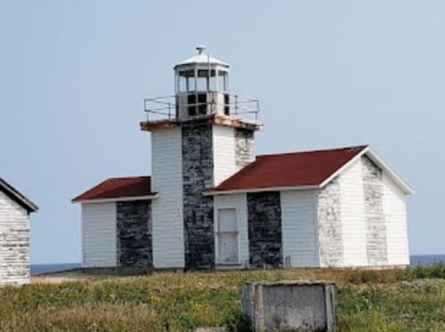
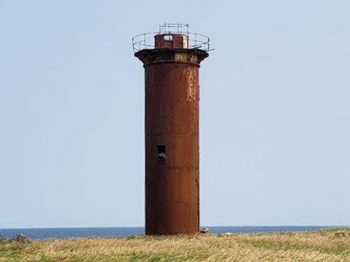
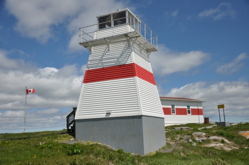
Lighthouses of Canada: Northern Newfoundland

Newfoundland and Labrador -- including both the Island of Newfoundland and the mainland territory of Labrador -- is the easternmost province of Canada. During the 17th century Newfoundland attracted both French and British fishermen, but France ceded its settlements to Britain in 1713. Long governed as a British colony, Newfoundland became a self-governing dominion under the British Crown in 1907 but gave up its dominion status in 1934, during the Great Depression. Newfoundland then joined Canada as the tenth province in 1949 following a referendum the previous year. The name of the province was changed from Newfoundland to Newfoundland and Labrador in 2001.

The north coast of the Island of Newfoundland faces the Labrador Sea and the east and south coasts face the open North Atlantic Ocean. The west coast faces the Gulf of Saint Lawrence. The Cabot Strait separates Newfoundland from Nova Scotia to the southwest and the Strait of Belle Isle separates the Island of Newfoundland from Labrador on the northwest. This page includes lighthouses of the northwest and north coasts of the island. There are separate pages for Southeastern Newfoundland, Southwestern Newfoundland, and Labrador.

Having a rocky and much-indented coast, Newfoundland established a large number of light stations, many of which remain active today. Until quite recently nearly all the lighthouses remained in the care of the Canadian Coast Guard. Now preservation organizations are beginning to appear in many communities.

Newfoundland is accessible by air and by Marine Atlantic car ferries from North Sydney, Nova Scotia. Ferry service is available year-round between North Sydney and Port aux Basques and in the summer between North Sydney and Argentia.

The Lighthouse Society of Newfoundland and Labrador works for the preservation and restoration of lighthouses in the province.

ARLHS numbers are from the ARLHS World List of Lights. CCG numbers are from the Newfoundland volume of the List of Lights, Buoys, and Fog Signals of Fisheries and Oceans Canada. Admiralty numbers are from Volume H of the Admiralty List of Lights & Fog Signals. U.S. NGA numbers are from Publication 110.

General Sources
Lighthouses of Newfoundland, Canada
Photos and notes by Kraig Anderson.
Lighthouses - Newfoundland
Photos by Karen Chappell and Joe Dawson.
Newfoundland Lighthouses
10 fine photos by Karl Josker.
Lighthouses of Newfoundland and Labrador
Karen Chappell moderates this group of photos available on Flickr.com.
Litehouseman's Newfoundland Lighthouses
A fine collection of photos by "Litehouseman."
Lighthouses in Newfoundland and Labrador
Photos by various photographers available from Wikimedia.
Online List of Lights - Northern and Eastern Canada
Photos by various photographers posted by Alexander Trabas.
List of Lights, Buoys, and Fog Signals
Official Canadian light lists.
GPSNauticalCharts
Navigational chart for this area.
Navionics Charts
Navigational chart for this area.

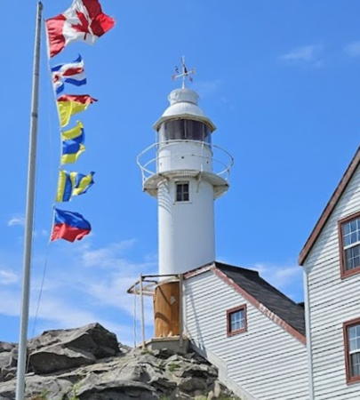
Lobster Cove Head Light
Lobster Cove Head Light, Gros Morne National Park, July 2011
Wikimedia Creative Commons photo
by Lukester878

Northwest Coast (Strait of Belle Isle) Lighthouses

Gros Morne National Park Lighthouses
Gros Morne National Park spans about 70 km (45 mi) of Newfoundland's west coast. The park is accessible by highway 430 from Deer Lake. The park includes the highest section of the Long Range Mountains, the northernmost ridge of the Appalachian Mountains.
* Woody Point (3)
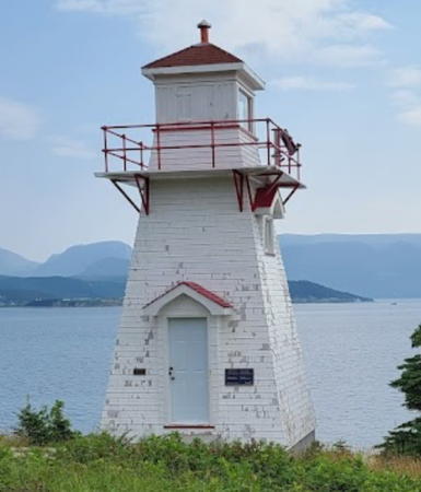
1959 (station established 1919). Active; focal plane 14 m (45 ft); red flash every 4 s. 6 m (20 ft) square pyramidal wood tower with lantern and gallery, painted white; lantern roof is red. A photo is at right, Geoff Smith has a photo, Werner Heller has a closeup photo, Trabas has Klaus Wolfgang's photo, Yung Vsop has a 2022 closeup, and Google has a street view and a satellite view. Anderson has photos of the first (1919) and second (1952) lighthouses; the first lighthouse was damaged by fire in 1922 and was largely rebuilt. The lighthouse received federal heritage designation in September 2016. Located at the entrance to the south arm of Bonne Bay near the community of Woody Point, a village surrounded by Gros Morne National Park. Site open, tower closed. Site manager: Canadian Coast Guard. . ARLHS CAN-703; CCG N-200; Admiralty H0168; NGA 2644.
*** Lobster Cove Head
1897. Active; focal plane 35 m (115 ft); white flash every 4 s. 8 m (28 ft) cylindrical cast iron tower with lantern and gallery, painted white. 2-story wood keeper's house now used as a national park visitor center and museum. A photo is at the top of this page, Robert Hiscock has a closeup, Rod Bailey has another good photo, Trabas has Klaus Wolfgang's photo, Erika Martin has a 2021 photo, and Google has a street view and a satellite view. Sibling of the Channel Head Light in Southwestern Newfoundland. In 2014 ownership of the lighthouse was transferred to Parks Canada. Located on the north side of the entrance to Bonne Bay, near Rocky Harbour. Site open, keeper's house open daily mid May through mid October, tower closed. Owner: Parks Canada. Site manager: Gros Morne National Park. . ARLHS CAN-646; CCG N-201; Admiralty H0164; NGA 2640.
* Cow Head
1905. Inactive since 1988. 5 m (18 ft) cylindrical cast iron tower with lantern and gallery, painted white with red trim. Jennifer Lam has a 2015 photo, Vince Ou has a 2021 photo, and Google has a distant satellite view. As of 1988 the abandoned lighthouse was endangered by neglect, rusted, and open to the elements. Mel Mashman's closeup, despite being tagged 2007, shows the lighthouse before it was restored. In November 2001 the Central Development Association won a grant for tourist development in the area, including restoration of the lighthouse. The restoration was completed in 2002. The lighthouse was repainted in 2019, as seen in S.D. Scannell's photo. Located on a headland near the town of Cow Head; a marked hiking trail leads to the lighthouse. Site and tower open. Owner/site manager: Town of Cow Head. . ARLHS CAN-680.
Woody Point Light
Woody Point Light, Woody Point, June 2006
Wikimedia Creative Commons photo by Psythe

Great Northern Peninsula West Coast Lighthouses

Newfoundland's Great Northern Peninsula extends about 250 km (155 mi) north northeast, separating the Gulf of Saint Lawrence from the Atlantic. The peninsula is 65-80 km (40-50 mi) wide for most of its length. At its northern end the Strait of Belle Isle separates the island of Newfoundland from Labrador. Highway 430 follows the west coast of the peninsula almost to its end.
Keppel Island (1)
1901. Inactive since 1992. Square pyramidal wood tower with lantern and gallery, painted with red and white horizontal bands. Active light (focal plane 37 m (121 ft); white light, 1 s on, 15 s off) on an 11 m (37 ft) square cylindrical skeletal tower. Fog horn (blast every 30 s). Andreas Köhler has a 2019 photo, Trabas has Brigitte Adam's photo, Lighthouse Digest has a closeup photo and Google has a satellite view of the station. The town of Port Saunders acquired the light station (except for the light tower) and hoped to restore the buildings, but these plans came to naught. In June 2013 the town put the keeper's houses and other outbuildings up for sale for $250,000. In 2015 the price had been lowered to $100,000, and the property was still for sale in 2017. The listing has since been removed and by 2020 the town was listing the lighthouse as an attraction. Located atop a bluff on an island in the entrance to Hawke's Bay, about 10 km (6 mi) south of Port au Choix. Accessible only by boat. Site open, tower closed. Owner/site manager: Town of Port Saunders. ARLHS CAN-661.
Keppel Island (2)
1992 (station established 1901). Active; focal plane 17 m (56 ft); white flash every 15 s. 11 m (36 ft) square cylindrical skeletal tower with lantern and gallery. Trabas has Brigitte Adam's photo but the lighthouse is partially hidden in Andreas Köhler's 2019 photo. Located adjacent to the historic light station. Site open, tower closed. CCG N-208; Admiralty H0156; NGA 2668.
* Pointe Riche (Port au Choix) (2)
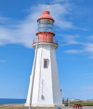
1892 (station established 1871). Active; focal plane 29 m (96 ft); white flash every 5 s. 19 m (63 ft) octagonal pyramidal wood tower with lantern and gallery, painted white; lantern is red. Mark Plummer's photo is at right, Wikimedia has Gordon Robertson's photo, Trabas has one of Anderson's photos, Cindie Houde has a 2021 photo, Davy Ray has a 2022 street view, and Google has a satellite view. The original lighthouse was destroyed by fire in August 1890. The present lighthouse was repainted in early 2009. Near the lighthouse, archaeologists have found remains of four distinct Indian cultures. Located at Port au Choix, north of Corner Brook on NF 430. Accessible by a dirt road or by hiking the Phillip's Garden Coastal Trial. Site open, tower closed. Site manager: Parks Canada (Port au Choix National Historic Site). ARLHS CAN-666; CCG N-211; Admiralty H0154; NGA 2680.
[Port au Choix (2?)]
Date unknown (station established 1913). Active; focal plane 8 m (26 ft); white flash every 6 s. 5 m (17 ft) square skeletal tower carrying a daymark colored red with a white horizontal band. No photo available but Bing has a satellite view. The original lighthouse was a small square building with lantern. Located on Querre Island, a small island in the entrance to the harbor of Port au Choix. Accessible only by boat. Site open, tower closed. CCG N-212; Admiralty H0152; NGA 2688.
Pointe Riche Light
Pointe Riche Light, Port au Choix, September 2002
Flickr Creative Commons photo by Mark Plummer
* New Férolle Peninsula (Férolle Point)
1913. Active; focal plane 27 m (91 ft); four white flashes, separated by 1 s, every 7.5 s. 19 m (64 ft) hexagonal cylindrical concrete tower with six ribs, lantern and gallery. Lighthouse painted white; lantern is red. The original 3rd order Barbier, Benard and Turenne Fresnel lens remains in use. A photo is at right, Lighthouse Digest has a Coast Guard photo, an excellent 2007 photo is available, John Van Hal has a 2015 photo, and Google has a satellite view of the station. This substantial lighthouse marks the southern entrance to the Strait of Belle Isle; it carries a light with a range of 20 nautical miles (37 km, 23 mi). The lighthouse has been designated as a Heritage Lighthouse. Located at Férolle Point, about 5 km (3 mi) west of New Férolle. Site open, tower closed. Site manager: Canadian Coast Guard. ARLHS CAN-655; CCG N-220; Admiralty H0148; NGA 2704.
Flowers Cove (Flowers Island) (1)
1899. Inactive since 1969. 15.5 m (51 ft) square cylindrical wood tower with lantern and gallery, rising from one corner of a 1-1/2 story wood keeper's house. Building painted white, lantern red. Andreas Köhler has a 2019 photo, Gary Barfitt has a 2006 photo, and Google has a satellite view of the station. The light station has been acquired by the town of Flower's Cove and the Straits Island Development Association has restored it as a tourist attraction. Trabas has Brigitte Adam's photo of the active light (focal plane 5 m (17 ft); green flash every 3 s) on a 4 m (13 ft) skeletal tower. Located on Rocky Island in the mouth of Flower's Cove. Accessible only by boat. Site open, tower closed. Owner/site manager: Town of Flower's Cove. ARLHS CAN-657. Active light: CCG N-213; Admiralty H0144; NGA 2724.
* Nameless Point (2)
2018 (?) (station established 1969). Active; focal plane 16 m (52 ft); white flash every 10 s. 12 m (39 ft) square cylindrical skeletal tower with gallery; the upper portion is enclosed by a daymark colored red with a white horizontal band. Trabas has Brigitte Adam's photo and Google has a distant satellite view. Anderson has a photo of the earlier light on a pyramidal skeletal tower.. More important than it might seem, this light stands opposite Labrador's Point Amour lighthouse in marking the narrowest passage of the Strait of Belle Isle. The strait here is about 15 km (9 mi) wide. Located at the end of a finger-like peninsula about 3 km (2 mi) north of Flowers Cove. Accessible by road. Site open, tower closed. CCG N-212.56; Admiralty H0142; NGA 2736.

Férolle Point Light, New Férolle, July 2013
Wikimedia Creative Commons photo by Magicpiano

North Coast (Labrador Sea) Lighthouses

Cape Norman and Cape Bauld Lighthouses
Cape Norman and Cape Bauld represent the northwestern and northeastern tips, respectively, of the Great Northern Peninsula. These lighthouses guide vessels entering the Strait of Belle Isle from the Atlantic.
* Cape Norman (3)
1964 (station established 1871). Active; focal plane 35 m (116 ft); three white flashes (separated by 6 s) every 30 s. 15 m (50 ft) octagonal pyramidal concrete tower; the original 3rd order Barbier, Benard & Turenne Fresnel lens is in use. Lighthouse painted white, lantern red. Fog horn (blast every 30 s). The keeper's house has been demolished, but a 1-story utility building survives. Mark Plummer's photo is at right, Trabas has Brigitte Adam's closeup photo, J. Turner has a 2009 closeup, Carla Sheedy has a 2022 view, a good 2003 photo is available, and Google has an indistinct satellite view. Sibling of Cape Bauld Light. The second lighthouse here, built in 1907, was the first of the buttressed ferroconcrete lighthouses. Located at the northernmost tip of the Great Northern Peninsula. Accessible by gravel road from Cooks Harbour. Site open, tower closed. Site manager: Canadian Coast Guard. . ARLHS CAN-679; CCG N-223; Admiralty H0140; NGA 1032.
Cape Bauld (3)
1962 (station established 1884). Active; focal plane 54 m (177 ft); white flash every 15 s. 15 m (50 ft) hexagonal pyramidal concrete tower with lantern and gallery; Fresnel lens of unknown order. Lighthouse painted white, lantern red. Fog horn (blast every 30 s). 2-story hipped-roof wood keeper's house (1922) and 1-1/2 story wood keeper's house (1961). The two buildings have been used in recent years as an inn but its not clear if this facility is still open. Chris Patey has a photo of the station, Lighthouse Digest has a Coast Guard photo, Ryan Patey has a panoramic photo, Mike Stooke has a distant view, and Google has a satellite view of the station. The second lighthouse here, built in 1908, was a buttressed ferroconcrete tower; Lighthouse Digest has two Coast Guard photos of that light. Located at the northern tip of Quirpon Island ("Quirpon" is pronounced "harpoon"). Accessible only by boat or helicopter (helipad provided). Site manager: Quirpon Lighthouse Inn . ARLHS CAN-652; CCG N-225; Admiralty H0132; NGA 1052.
Cape Norman Light
Cape Norman Light, Cooks Harbour, September 2002
Flickr Creative Commons photo by Mark Plummer

St. Anthony and Conche Area Lighthouses
St. Anthony and Conche are towns on the eastern side of the Great Northern Peninsula; St. Anthony is the largest town on the Peninsula with a population of more than 2000.
* Fox Point (Fishing Point, St. Anthony) (3)
2002-03 (station established 1912). Active; focal plane 27 m (88 ft); white flash every 15 s. 8 m (26 ft) square pyramidal tower with lantern and gallery. Lighthouse painted white with red trim; the octagonal lantern is unpainted gray metallic. Fog horn (blast every 60 s). Pavel Trebutov's photo is at right, Trabas has Klaus Wolfgang's photo, Werner Heller has a closeup, Trebutov's more distant view shows the fog signal building and keeper's house, and Google has a street view and a satellite view. A 1-story wood keeper's house is now used as a café; another keeper's house was moved into town as residence. The second (1960) lighthouse a\was a square skeletal tower covered by white siding. Located at the south entrance to the harbor of St. Anthony. Accessible by car and by a hiking trail from town. Site open, tower closed. Site manager: Lightkeepers Seafood Restaurant. . ARLHS CAN-684; CCG N-240; Admiralty H0730; NGA 1068.
* Conche (Silver Point) (1)
1914. Inactive since 1992. 4 m (14 ft) square pyramidal wood tower with lantern and gallery. Lighthouse painted white. The active light (focal plane 20 ft; red light, 1 s on, 5 s off) has been moved to a square cylindrical aluminum skeletal tower a few feet farther from shore. A 2015 photo is available, David Fitzpatrick's photo shows both lights, Chinna Arun has a view from the sea, and Bing has an indistinct satellite view. Sibling of Westport Cove. The lighthouse was in severe disrepair until it was rebuilt by local volunteers. A boardwalk provides access to the tower. Located just offshore on Silver Point at the entrance to Conche Harbour. Conche is accessible by a gravel road off NF 433. Site open, tower closed. Owner/site manager: Village of Conche. ARLHS CAN-749; CCG N-247; Admiralty H0722; NGA 1096.

Fox Point Light, St. Anthony, September 2004
Flickr Creative Commons photo by Pavel Trebutov

Baie Verte Peninsula Lighthouses

The broad Baie Verte Peninsula projects from the north coast of Newfoundland, separating White Bay on the west from Notre Dame Bay on the east.
* Westport Cove
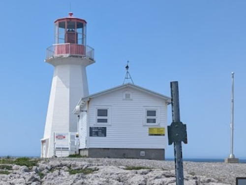
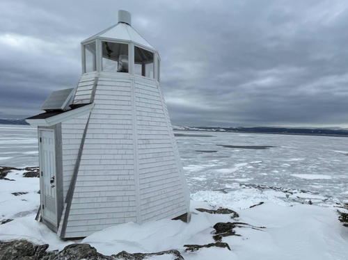
1906. Active; focal plane 10 m (33 ft); white flash every 4 s. 5.5 m (18 ft) octagonal pyramidal wood tower with lantern. Lighthouse painted white. Lighthouse Digest has a closeup photo, the Town of Westport has a winter 2022 photo, and Google has a satellite view. A good candidate for the title of Canada's smallest lighthouse. Located on the north side of the harbor, on the east side of White Bay; accessible by a hiking trail from the town of Westport Cove. Site open, tower closed. Site manager: Canadian Coast Guard. ARLHS CAN-702; CCG N-260; Admiralty H0704; NGA 1140.
Gull Island (Cape St. John) (1)
1884. Inactive since 2014. 11.5 m (38 ft) cylindrical cast iron tower with lantern and gallery, attached by a long covered passageway to a 1-story keeper's house. Lighthouse painted with red and white vertical stripes; lantern roof is white. Additional 2-story keeper's house and other buildings. The active light (focal plane 160 m (525 ft); white flash every 10 s) has been moved to a 5 m (17 ft) skeletal tower carrying a daymark colored red with a white vertical stripe. Fog horn (3 s blast every 30 s). An aerial photo is at right, Parks Canada has a 1992 closeup of the light tower and Google has a distant satellite view of the station. Lighthouse Digest has a July 2004 feature article by Jeremy D'Entremont on life at this isolated station. In 2014 ownership was being transferred, it's not clear to whom. Located at the top of a high, barren island off the northeastern tip of the Baie Verte Peninsula. Accessible only by helicopter or by boat in heavy seas. Site and tower closed. Site manager: Canadian Coast Guard. ARLHS CAN-660; CCG N-326; Admiralty H0686; NGA 1172.

Gull Island Light
undated Canadian Coast Guard photo

Notre Dame Bay Lighthouses

Notre Dame Bay is a large bight occupying the central third of the north coast of Newfoundland. The shores of the bay are dissected into numerous smaller bays with many islands.
Long Island East End (1 ) (relocated)
1904. Removed in 2009 and later relocated. 9 m (30 ft) cast iron tower with lantern and gallery, mounted on an octagonal concrete base. Entire lighthouse is white. Keeper's house demolished. Lighthouse Digest has a Coast Guard photo of the lighthouse at its original location. The active light there (focal plane 31 m (103 ft); white flash every 6 s) is on a square skeletal mast with a daymark colored red with a broad white horizontal band. Anderson has a photo of the new tower standing beside the base of the old one, but the tower is gone from Google's satellite view of the site. The historic lighthouse was restored in 1990, but by 2009 it had deteriorated to the point of being dangerous to maintain. The Coast Guard demolished it but saved the pieces and the lighthouse was reassembled on a slope above the Long Island ferry terminal. Barbara Colbourne has a blog entry with a distant view of the relocated lighthouse and Google has a satellite view. . Formerly located on the eastern end of Long Island, on the south side of Notre Dame Bay, now at the southwestern end of the island. The island is accessible by car ferry from Pilley's Island. Site open, tower closed. Site manager: Canadian Coast Guard. ARLHS CAN-682. Active light: CCG N-340; Admiralty H0675; NGA 1212.
Surgeon Cove Point
1911. Inactive, probably since 2005. 9 m (30 ft) cast iron tower with lantern and gallery. Lighthouse painted with red and white vertical stripes; lantern roof is white. The active light (focal plane 74 m (242 ft); white flash every 5 s) is on a 4.5 m (14 ft) skeletal tower carrying a daymark colored with red and white horizontal bands. Fog horn (blast every 30 s). 1-story keeper's house and other buildings. A photo is at right, Lighthouse Digest has an older Coast Guard closeup and Bing has a satellite view of the station. Endangered. In 2005 the station was transferred to the Town of Lewisporte, and in 2008 the town leased the station to Canoe Hill Adventures (now Adventures Newfoundland). The company planned to restore the keeper's house for overnight accommodations, but this work was greatly delayed. Visitors in 2012 found the lighthouse in poor condition and it looks terrible in a 2018 photo. The restoration was finally accomplished in 2020 and the building, called The Escape, is now open for overnight stays by kayakers. The company has the November 2021 photo seen at right. Located on an island in the Bay of Exploits, on the southeast side of Notre Dame Bay. Site open, tower closed. Owner: Town of Lewisporte. Site manager: Adventures Newfoundland. ARLHS CAN-490; CCG N-347; Admiralty H0656; NGA 1240.

Surgeon Cove Point Light, Bay of Exploits, November 2021
Google Maps photo by Adventure Central Newfoundland
*** Long Point (Twillingate)
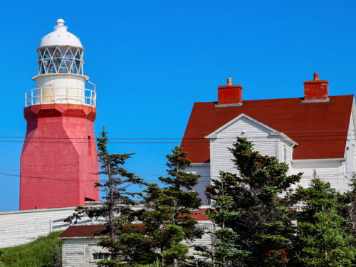
1876. Active; focal plane 101 m (331 ft); white flash every 5 s. 15 m (50 ft) concrete-encased brick tower with lantern and gallery, square cylindrical at the base and octagonal conical above, attached by a covered passageway to a 1-1/2 story keeper's house. Tower painted red, lantern and watch room white. Fog horn (blast every 60 s). Staffed Coast Guard light station. André Lafargue's photo is at right, Lighthouse Digest has another of Lafargue's photos, Peter Brake has a good 2008 photo, a 2011 photo is available, Trabas has Brigitte Adam's closeup photo, and Google has a street view and a satellite view of the station. This lighthouse has a unique design. The brick tower was encased in concrete after it cracked during a 1929 earthquake. In 2012 the lighthouse hosted a special exhibit of Titanic artifacts. The island has a spectacular site: located at Devil's Cove Head on North Twillingate Island, with a sweeping view of Notre Dame Bay and its rocky islands. The island is linked to the mainland by a causeway. Located at the northern tip of the island, at the end of highway 340. Site open, museum open during the summer (hours not available), tower closed. Site manager: Canadian Coast Guard (Long Point Lighthouse) . ARLHS CAN-285; CCG N-358; Admiralty H0640; NGA 1272.
Bacalhao Island
1894. Active; focal plane 106 m (348 ft); white flash every 10 s. 14 m (45 ft) round cylindrical cast iron tower with lantern and gallery, attached to a small utility building. Lighthouse painted in a red and white spiral (candy-stripe) pattern; lantern roof is red. Fog horn (blast every 30 s). Next to the lighthouse a sector light is displayed on demand from a square cylindrical skeletal tower carrying a red and white daymark. Lighthouse Digest has a Coast Guard photo and Bing has a distant satellite view. The original keeper's house was removed in 1966; there is modern housing located 400 m (1/4 mi) northeast. Located at the southwest end of the island, about 25 km (15 mi) east of Twillingate. Accessible only by boat. Site open, tower closed. Site manager: Canadian Coast Guard. ARLHS CAN-647; CCG N-363; Admiralty H0636; NGA 1300. Sector light: CCG N-362.5; Admiralty H0635; NGA 1302.
Twillingate Light
Long Point (Twillingate) Light, Twillingate, August 2007
photo copyright André Lafargue; used by permission

Hamilton Sound and Wadham Islands Lighthouses

Hamilton Sound lies between Fogo Island and the mainland on the northeastern shoulder of Newfoundland.

[Change Islands (3)]
Date unknown (2014?) (station established 1901). Active; focal plane 14 m (46 ft); white flash every 4 s. 9.5 m (31 ft) square skeletal mast carrying a daymark colored red with a white horizontal band. No photo available but Bing has a satellite view. The original lighthouse, a square pyramidal wood tower, has been demolished. The present light replaced a square pyramidal skeletal tower. Located at the southwestern tip of South Change Island. The island is accessible by ferry from Farewell. Site open, tower closed. ARLHS CAN-836; CCG N-368; Admiralty H0626; NGA 1332.
* Burnt Point (3)
1990 (station established 1905). Active; focal plane 13 m (43 ft); white flash every 6 s. 9 m (30 ft) square cylindrical skeletal tower with lantern and gallery. Fog horn (one 4 s blast every 60 s). The entire structure is gray metallic. Lee Shelp has a closeup photo of the light tower, there's a closeup photo of the lighthouse in action, Lighthouse Digest has a Coast Guard aerial photo, and Google has an indistinct satellite view. The second lighthouse (1950s?), a square tower rising from a corner of a square fog signal building, was demolished in 1990. The Fogo Island Marine Interpretation Centre displays logbooks and other artifacts from the light station. Located on a point of land marking the east side of the entrance to Seldom Harbour, on the south side of Fogo Island. The island is accessible by ferry from Farewell. Site open, tower closed. ARLHS CAN-677; CCG N-378; Admiralty H0612; NGA 1400.
Offer Wadham Island
1858 (Robert Oke). Inactive since early 1990s (?). 12 m (40 ft) (?) octagonal cylindrical tower with gallery, brick and stone encased in concrete. Lantern removed. The active light is on a 7 m (23 ft) square cylindrical steel skeletal tower (focal plane 30.5 m (100 ft); white flash every 3 s). Aidan Mouland has a 2021 closeup photo, Lighthouse Digest has a Coast Guard photo, and Google has a distant satellite view. The tower was originally brick; it was encased in cement in 1863, in cast iron in 1893, and then in concrete in 1961. Now abandoned, it is clearly endangered. Located on a small island between Fogo Island and Musgrave Harbour, in the entrance to Hamilton Sound. Accessible only by boat. Site open, tower closed. Site manager: Canadian Coast Guard. ARLHS CAN-696. Active light: CCG N-396; Admiralty H0584; NGA 1440.
Peckford Island (2)
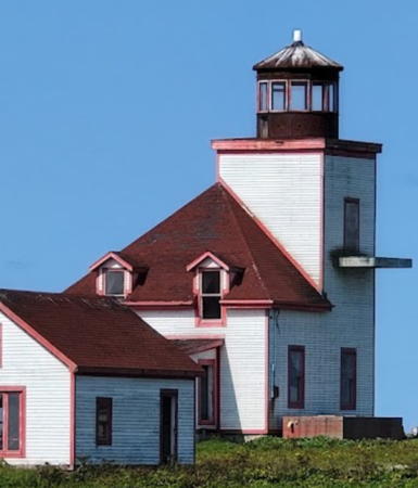
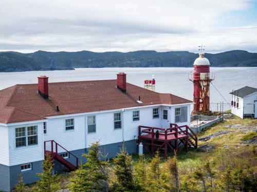
1961 (station established 1910). Inactive. 7 m (24 ft) square cylindrical shingled brick tower with lantern and gallery, rising from the center of a 1-story shingled fog signal building. Entire building painted with black and white vertical stripes. 1-story keeper's house (1961). The active light (focal plane 16 m (51 ft); white flash every 10 s) is on a 9.5 m (31 ft) square skeletal tower carrying a daymark colored red with a white horizontal band. Aidan Mouland has the 2021 photo of the station seen at right and a closeup of the light tower, and Bing has a satellite view of the station. Anderson has a historic photo of the first lighthouse, an octagonal wood tower. Now abandoned, the historic lighthouse is endangered. Located on the southeastern tip of Peckford, the largest of the Wadham Islands, about 6.5 km (4 mi) southwest of Offer Wadham Island. Accessible only by boat. Site open, tower closed. Site manager: Canadian Coast Guard. ARLHS CAN-697; CCG N-395. Active light: Admiralty H0586; NGA 1444.

Offer Wadham Light, Wadham Islands
Canadian Coast Guard photo
North Penguin Island (1)
1890. Inactive since the mid 1980s. 17 m (56 ft) round cylindrical cast iron tower, lantern removed. The keeper's house and other station buildings have been demolished. The active light is on a 7 m (23 ft) square cylindrical steel skeletal tower (focal plane 14.5 m (48 ft); white flash every 6 s). Aidan Mouland has a 2021 photo and Google has a satellite view. The abandoned lighthouse is clearly endangered. Lighthouse Digest has an article on former keeper George Simms. The name "penguin" originally applied to the great auk, a northern seabird now extinct. The two Penguin Islands lie to the south of the Wadham Islands. Located on the eastern tip of the island. Accessible only by boat. Site open, tower closed. Site manager: Canadian Coast Guard. ARLHS CAN-841. Active light: CCG N-403; Admiralty H0588; NGA 1464.

West Side Bonavista Bay Lighthouses
Bonavista Bay is a large embayment at the northeastern corner of Newfoundland. The three lights listed here are on islands on the west side of the bay; for lighthouses of the more accessible eastern shore, see the Southeastern Newfoundland page.

Cabot Islands (Bonavista Bay)
1880 (Austin Oke). Active; focal plane 22.5 m (74 ft); white flash every 5 s. 15 m (50 ft) octagonal tower with lantern and gallery, cast iron encased in concrete. Lighthouse painted with horizontal red and white bands; lantern roof is white. Fog horn (blast every 60 s). Keeper's house demolished, but the station includes the original fog signal building, generator house, and modern keeper's house. The active light (focal plane 14 m (46 ft); white flash every 6 s) is on a short skeletal tower. Lighthouse Digest has a Coast Guard photo and Bing has a satellite view. In 1960 the keeper's house was demolished and the original round cast iron tower was encased in concrete; this changed its cross-section from round to octagonal. Located on a small island 6 miles southeast of Cape Freels in the northern entrance to Bonavista Bay. Accessible only by helicopter or by boat in heavy seas. Site and tower closed. Site manager: Canadian Coast Guard. ARLHS CAN-068; CCG N-406; Admiralty H0576; NGA 1496.
Puffin Island (2)
1951 (station established 1873). Active; focal plane 21 m (70 ft); white light, 2.5 s on, 2.5 s off. 8 m (25 ft) square pyramidal wood tower with a square wood lantern and gallery. Lighthouse painted white with a single horizontal red band. Fog horn (blast every 30 s). 2-story wood keeper's house (1951) and two utility buildings, all painted white with a single horizontal red band. This is a staffed station, one of the few remaining in eastern Canada; crews serve 28-day shifts. The Coast Guard photo at right shows that the lighthouse has been restored in recent years with a modern lantern and new siding. The Coast Guard photo on the Lighthouse Digest page shows the previous appearance of the tower. Andreas Köhler has a 2019 view from the sea and and Google has a satellite view and a very distant street view of the station. The Coast Guard refurbished and repainted the lighthouse in 2015. The original lighthouse was a square granite tower attached to a granite keeper's house. Located on an island about 400 m (1/4 mi) off Greenspond on the northwest side of Bonavista Bay. Accessible only by boat, but there's a good view from Greenspond. Site open, tower closed. Site manager: Canadian Coast Guard. ARLHS CAN-418; CCG N-430; Admiralty H0556; NGA 1556.
Little Denier Island
1888. Active; focal plane 91 m (298 ft); white flash every 3 s. 9 m (30 ft) round cylindrical cast iron tower with lantern and gallery; solar-powered lens. Entire lighthouse painted with vertical red and white stripes. The keeper's house and other light station buildings have all been demolished. Lighthouse Digest has a Coast Guard photo, and Google has a distant satellite view. Located on a high island east of Salvage, off the tip of the Eastport Peninsula. Essentially inaccessible; landing on the steep-sided island is extremely difficult. Site and tower closed. Site manager: Canadian Coast Guard. ARLHS CAN-663; CCG N-441; Admiralty H0543; NGA 1608.

Puffin Island Light, Greenspond, undated
Canadian Coast Guard photo (no longer online)

Information available on lost lighthouses:

Adjoining pages: North: Labrador | Southeast: Southeastern Newfoundland | Southwest: Southwestern Newfoundland

Return to the Lighthouse Directory index

Posted December 2002. Checked and revised June 26, 2023. Lighthouses: 23. Site copyright 2023 Russ Rowlett and the University of North Carolina at Chapel Hill.