Lighthouses of the United States: Western New York

The United States of America is a federal union of 50 states and a capital district. The northeastern state of New York includes in the southeast the great port and financial center of New York City and Long Island extending to the east of the city; in the west and north it extends to Lakes Erie and Ontario and the lower St. Lawrence River.

Rich in waterways, the state of New York is equally rich in lighthouses. This page includes the lighthouses of western New York from Wayne County westward including the Rochester and Buffalo areas. There are additional pages for Central and Northern New York, for New York City and the Hudson River. and for Long Island.

Navigational aids in the United States are operated by the U.S. Coast Guard but ownership (and sometimes operation) of historic lighthouses has been transferred to local authorities and preservation organizations in many cases. Aids to navigation on Lakes Erie and Ontario are operated by the Coast Guard Ninth District in Cleveland, Ohio; the Aids to Navigation Team Buffalo does the maintenance work.

ARLHS numbers are from the ARLHS World List of Lights. USCG numbers are from Volume VII. For lights close to the Canadian border CCG numbers are from the Canadian Coast Guard's List of Lights, Buoys and Fog Signals.

General Sources
New York Lighthouses
Photos, travel directions, and historical accounts by Kraig Anderson.
Lighthouses of New York
Photos and accounts by Bryan Penberthy.
Lighthouses in New York
Photos by various photographers available from Wikimedia.
New York, United States Lighthouses
Aerial photos posted by Marinas.com.
Lake Ontario Lighthouses and Lake Erie Lighthouses
Photos by C.W. Bash.
Lighthouses of Lake Ontario and Lighthouses of Lake Erie
Part of William Britten's Lighthouse Getaway site. Photos and brief accounts of more than a dozen lighthouses.
Lake Erie Lighthouses
Excellent photos by Karl Josker.
Leuchttürme USA auf historischen Postkarten
Historic postcard images of U.S. lighthouses posted by Klaus Huelse.
U.S. Coast Guard Navigation Center: Light Lists
The USCG Light List can be downloaded in pdf format.
NOAA Nautical Charts
Official nautical charts for the coast can be viewed online.
Navionics Charts
Navigation chart for western New York.


Sodus Bay Light, Sodus Point, September 2015
Google Maps photo by Donna Robinson

Lake Erie Lighthouses

Chautauqua County Lighthouses
*** Barcelona (Portland Harbor)
1829. Inactive since 1859 (a decorative natural gas "streetlight" has been displayed since 1962). Charted as a landmark. 40 ft (12 m) unpainted old-style round fieldstone tower. The original lantern was removed long ago; an open "lantern" platform was added in 1962. Jason Crumbacher has a 2016 photo, Donovan Myers has a 2021 photo, and Google has a street view and a satellite view. Lighthouse Digest has Dale Pappert's 1999 article on the history of the light station, which was the first in the country to be lit with natural gas (1831). The original 1-1/2 story fieldstone keeper's house, modified in the 1890s, became a private residence owned for more than 120 years by the Patterson family. It was renovated by Ann and Bruce Mulkin after they bought the property from the Pattersons in 1998. In April 2005 the Mulkins put the property up for sale and in 2008 it was acquired by New York State Parks. The Town of Westfield has a license agreement with the park service to manage the property in cooperation with the local Chamber of Commerce and Chautauqua County Visitors Bureau. Volunteers staff the keeper's cottage as the Westfield Visitor Center during the summer. In 2023 the State Parks agency was working on the design of a restoration project for the tower. Located on Lake Street (NY 5) at Barcelona harbor, off I-90 at the Westfield exit; there is public parking at the harbor access area adjacent to the tower. Site open, keeper's cottage open daily during the summer, tower closed. Owner: New York State Parks (Barcelona Lighthouse). Site manager: Town of Westfield. . ARLHS USA-038.
**** Dunkirk (Point Gratiot) (3)
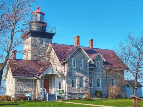
1875 (station estalished 1827). Active; focal plane 82 ft (25 m); white light occulting every 4 s. 61 ft (18.5 m) square cylindrical stone tower with lantern and gallery, attached to a 2-story brick Victorian keeper's house; the tower's brick veneer surrounds an 1857 rubblestone tower. Original 3rd order Fresnel lens (1857). Upper 2/3 of tower painted white; lower 1/3 unpainted gray stone. Lantern painted red. The keeper's house is now a museum. Original oil house and other buildings. NOAA C-MAN automatic weather station. A 2020 photo is at right, Anderson's page has nice photos, a 2021 photo is available, Huelse has a historic postcard view, the Coast Guard has an 1885 photo, Bruce Isaacson has a street view, and Google has a satellite view. Displays on site include the next three lighthouses listed, various buoys, and a buoy tender. The lighthouse began to deteriorate after being automated in 1962; a group of veterans and citizens banded together to sign a lease of the property from the Coast Guard and began a highly successful restoration. At the light's 125th anniversary celebration, in July 2000, ownership of the tower was transferred to the local preservation society. In the summer of 2010 storm waves exposed the foundations of the 1827 lighthouse. Located on Lighthouse Point Road, off NY 5 in Dunkirk. Site open; museum and tower open daily May through October with extended hours in July and August. Owner/site manager: Dunkirk Lighthouse and Veterans Park Museum . ARLHS USA-248; USCG 7-3410.
* Buffalo Harbor South Entrance North Side (relocated to Dunkirk)
1903. Inactive since 1988. 29 ft (9 m) "bottle" or "bubble" shaped cast iron tower, sibling of Buffalo North Breakwater. Relocated from Buffalo this light now stands at the entrance to the Dunkirk Lighthouse Museum. Dan and Kathleen Mitscher have a 2021 photo, Britten has a closeup photo, and Google has a street view and a satellite view. Site open, museum daily May through October with extended hours in July and August, tower closed. Owner/site manager: Dunkirk Lighthouse and Veterans Park Museum. ARLHS USA-1310.
* Dunkirk Pierhead (2) (relocated to Dunkirk)
1939. Inactive. Approx. 65 ft (20 m) square pyramidal steel skeletal tower with enclosed equipment room in the base. Robert English has a photo and Google has a satellite view but trees hide the lighthouse in Google's street view. Relocated from the pier for display at the Dunkirk Lighthouse Museum, the tower is a short distance west of the museum entrance. Site open, museum open daily May through October with extended hours in July and August, tower closed. Owner/site manager: Dunkirk Lighthouse and Veterans Park Museum. ARLHS USA-1303.

Dunkirk Light, Dunkirk, November 2020
Instagram photo by Chautauqua County Photos
* Grand Island Range Front (relocated to Dunkirk)
1917. Inactive. Approx. 30 ft (9 m) square pyramidal steel skeletal tower with enclosed equipment room in the base. Lighthouse Digest has Dave Collinge's photo but misidentifies the light as the rear light. Antony Hayes has a photo, Bruce Isaacson has a street view, and Google has a satellite view. Relocated from Grand Island, north of Buffalo, for display in front of the main lighthouse at the Dunkirk Lighthouse Museum. Site open, museum open daily May through October with extended hours in July and August, tower closed. Owner/site manager: Dunkirk Lighthouse and Veterans Park Museum. ARLHS USA-1144.
[Dunkirk Pierhead (3)]
Active; focal plane 36 ft (11 m); red flash every 6 s. Round cylindrical "D9" tower, painted white with a narrow red band. This light replaced a skeletal tower (1939), now on display at Dunkirk Light. Robert English has a photo and Google has a satellite view. Huelse has a postcard view of the original light, a square wood tower with lantern and gallery. Located at the west end of the detached breakwater of Dunkirk harbor. Accessible only by boat. Site and tower closed. Owner/site manager: U.S. Coast Guard. ARLHS USA-249; USCG 7-3435.

Erie County (Buffalo Area) Lighthouses
Buffalo is the largest city of Western New York with a metropolitan population of more than 1 million. The completion of the Erie Canal in 1825 linked the city to the Hudson River and the Atlantic, making it a major port for transshipment between the East Coast and the Great Lakes. The city's harbor is at the eastern end of Lake Erie and at the head of the Niagara River, 16 miles (25 km) south of Niagara Falls.

Buffalo Harbor South Entrance (South Buffalo) (1)
1903. Inactive since 1993. 29 ft (9 m) round steel tower with lantern and gallery, mounted on a concrete platform on the Stony Point Breakwater. The original 4th order Fresnel lens was transferred to the Buffalo Main light in 1987; in 2013 it was removed, restored, and displayed at the Heritage Discovery Center in South Buffalo. The lighthouse has been replaced by a post light (focal plane 36 ft; white flash every 6 s) at the end of the breakwater. A 2022 photo is at right, Josker has a remarkable closeup photo, Robert English has a good photo, Bash has a photo, Marinas.com has aerial photos, and Google has a satellite view. The Coast Guard has a 1911 photo. In 2008 this poorly-known lighthouse became available for transfer under NHLPA. The Buffalo Lighthouse Association applied for ownership and its application was approved. In 2012 the Association was seeking $185,000 for an initial project to stabilize the lighthouse. According to the Association, "An $850,000 project is planned to restore the station and reuse it for maritime education in partnership with the M.A.I.N. Foundation, as a shoreline study center and as a site for amateur radio activities." In 2014 volunteers worked to secure the lighthouse, patching the roof and replacing windows. In 2022 restoration was boosted by a grant of $137,800 from the Buffalo and Erie County Greenway Funding Committee. Located at the elbow of a breakwater marking the south side of the south entrance to Buffalo harbor, about 3 miles (5 km) south of the Buffalo light. Accessible only by boat; there is at best a very distant view from the NY 5 crossing of the Union Canal. Site and tower closed. Owner/site manager: Buffalo Lighthouse Association . ARLHS USA-091. Active light: USCG 7-2905.

South Buffalo Light, Buffalo, July 2022
Facebook photo posted by South Buffalo Lighthouse
Buffalo Harbor (Outer Breakwater, North Entrance) (3)
1961 (station established 1872). Active; focal plane 71 ft (21.5 m); green flash every 2.5 s. 71 ft (21.5 m) octagonal cylindrical tower with navigation light, painted white. No lantern. Fog horn (2 blasts every 30 s) on demand. Corey Seeman's photo is at right, Josker has a good closeup photo, and Bing has a satellite view. Anderson has a National Archives photo of the 1872 lighthouse. The Coast Guard has a historic photo of the 1914 lighthouse, which was similar to the Lorain Harbor Light in Ohio. It was demolished after being severely damaged by a collision with the freighter Frontenac in 1958. Located at the south end of the outer (detached) breakwater off the mouth of the Buffalo River. Accessible only by boat. Harbor tours available. Site and tower closed. Owner/site manager: U.S. Coast Guard. ARLHS USA-1299; USCG 7-2680.
Buffalo Intake Crib
1908. Active (maintained by the City of Buffalo); focal plane 60 ft (18 m); two white flashes every 5 s. Navigation light mounted atop a lantern at the peak of a conical structure above a circular stone crib. The crib is a water supply intake. Josker has a fine photo, Corey Seeman has a more distant view, and Marinas.com has aerial photos, but the light is only a fuzzy spot in Google's satellite view. Located offshore about 350 yd (300 m) southeast of Horseshoe Reef. Accessible only by boat; visible from Buffalo Main Light. Harbor tours available. Site and tower closed. Owner/site manager: City of Buffalo. ARLHS USA-1301; USCG 7-2670.
Horseshoe Reef (?)
1856. Inactive since 1930; charted as a landmark. Originally a square wood keeper's house with a lantern on the roof, mounted on an iron frame platform above a square stone foundation. This lighthouse was built in Canadian waters by the U.S. Lighthouse Board, but in 1913 the international border was moved 100 ft (30 m) west so that the lighthouse would be in the United States. The building has completely collapsed and vanished, leaving only the iron framework and the lantern. in recent years. Josker has a great closeup photo. In December 2021 a storm removed part of the foundation leaving the ruins ready to fall, and they may have done so because they are not seen in Google's current satellite view. The lighthouse is a longtime resident on the Lighthouse Digest Doomsday List. Located on Middle Reef (actually not Horseshoe Reef) about 300 yd (275 m) northwest of the Intake Crib Light. Accessible only by boat; visible from Buffalo Main Light. Harbor tours available. Site and tower closed. Owner/site manager: unknown. ARLHS USA-386.

Buffalo Harbor Light, Buffalo, July 2008
Flickr Creative Commons photo copyright Corey Seeman
* Buffalo Main (2)
1833 (station established 1818). Reactivated (inactive 1914-1987; now privately maintained and unofficial; charted as a landmark); focal plane 76 ft (23 m); continuous white light; charted as a landmark. 61 ft (18.5 m) octagonal limestone tower with lantern and gallery. The 3rd order Chance Brothers Fresnel lens used here in 1905-1914 and at the Outer Breakwater Light (see above) in 1914-1958 is now displayed at the Buffalo History Museum. Keeper's house demolished. Next to the lighthouse is the active Buffalo River Light (focal plane 25 ft (7.5 m), red light occulting once every 4 s) on a post. Brandon Blackwell's photo is at right, Anderson has a good page with excellent photos, Matt Tanner has a 2021 photo, a 2022 photo and a 2023 drone view are available, Marinas.com has aerial photos, Huelse has a historic postcard view, and Google has a satellite view and a street view across the waterway entrance. A historic and beautifully restored lighthouse. In the 1950s the Army Corps of Engineers planned to demolish the lighthouse as part of a harbor improvement project, but the Corps relented in the face of strong public opposition. The Coast Guard leased the tower to the Buffalo Lighthouse Association in 1984. In 2010 the Coast Guard agreed to give up some of its property to allow access to the lighthouse. In October 2010 it was announced that the first phase of this transfer would allow the lighthouse to reopen to the public in 2012. In April 2011 a contract was awarded for $170,000 to restore the exterior stonework. In August 2013 the 4th order lens formerly mounted in the lantern was removed for restoration, and in September 2015 it was replaced by a new and historically accurate replica 3rd order lens. A ceremony relighting the light was held in June 2016. In 2021 the Corps of Engineers repaired the 195-year old South Pier leading to the lighthouse. Located on the South Pier Promenade at the mouth of the Buffalo River (the western end of the Erie Canal), off the Buffalo Skyway (NY 5) at the end of Fuhrmann Boulevard. Google has a street view showing the start of the paved path to the lighthouse just to the right of the entrance for the Coast Guard station. Street parking is available along Fuhrmann Boulevard. Site open, tower closed. Owner: U.S. Coast Guard. Lessee/site manager: Buffalo Lighthouse Association . ARLHS USA-090. Active light: USCG 7-2730.
* Buffalo North Breakwater
1903. Inactive since 1985. Unusual design: 29 ft (9 m) "bottle" or "bubble" shaped cast iron tower, painted white. Relocated in 1985 for display near the Buffalo light, the light appears in Matt Tanner's 2021 photo and in C.W. Bash's photo, and Google has a satellite view. Other displays include a bell buoy from the 1920s and a fog bell. In the background of Bash's photo is the Buffalo River Light (focal plane 25 ft (7.5 m), red light occulting once every 4 s) carrying a red triangular daymark. Located a few feet west of the Buffalo Main Light (previous entry). Site open, tower closed. Owner/site manager: Buffalo Lighthouse Association. ARLHS USA-1302.

Buffalo Main Light, Buffalo Harbor, October 2009
Wikimedia/U.S. Coast Guard public domain photo
by Petty Officer 3rd Class Brandon Blackwell

Niagara River Lighthouses

Erie County (Buffalo Area) Lighthouses
Strawberry Island Lower Cut Range Rear (4?)
Date unknown (station established 1908). Active; focal plane 83 ft (25 m); continuous red light visible only on the range line. Approx. 75 ft (23 m) square skeletal tower. The tower also carries a rectangular daymark painted red with a white vertical stripe. No photo available but Google has a satellite view and a street view from 65 Fuller Street. The range guides vessels southbound in the Niagara River channel east of Grand Island. The front light is on a post beside the Niagara Thruway (I-190). Lighthouse Explorer has a photo of the original lighthouse, which was similar to the Niagara River Range Rear Light (see below). This lighthouse was too short; it was replaced in 1916 by a skeletal tower. Located off Niagara Street between Collaton Street and Briggs Avenue in north Buffalo. Site and tower closed (private property). ARLHS USA-1221; USCG 7-3020.
* [Strawberry Island Upper Cut Range Front (3)]
Date unknown (station established 1908). Active; focal plane 25 ft (7.5 m); continuous red light visible only on the range line. 6 m (20 ft) post carrying a rectangular daymark painted red with a white vertical stripe and mounted on a square concrete pier. Google has a street view and a satellite view. The modern light is mounted on the pier of the original lighthouse, which was an octagonal wood tower similar to the Niagara River Range Rear Light (see below). The historic lighthouse was replaced by a skeletal tower in 1951. The range guides vessels northbound in the Niagara River channel east of Grand Island. The rear light is on a post beside the Riverside Park swimming pool. Located just off the river bank, next to the Riverwalk, north of Crowley Avenue and opposite exit 14 of the Niagara Thruway (I-190). Site open, tower closed. ARLHS USA-819; USCG 7-3000.
Niagara River Range Rear (2) (relocated to Grand Island)
1899 (station established 1885). Inactive since 1929; charted as a landmark. 51 ft (15.5 m) white octagonal wood tower with frame lantern and gallery. Tower painted white; the lantern roof is blue with a gold ventilator ball. Danielle Jordan's 2019 photo is at right, Sheryl Shields has a 2022 closeup, C.W. Bash has a photo, and Google has a satellite view. The original location of this tower was near the intersection of Niagara Street and Busti Avenue in Buffalo. The range, which guided vessels from Lake Erie into the upper Niagara River, was deactivated after the Peace Bridge was completed in 1927. The lighthouse was sold and relocated to Grand Island in 1931 by Frank and Charles Fix, who owned the Bedell House Hotel. Later it was owned by Mike Steffen, whose property has since been purchased by the Buffalo Launch Club. For many years the lighthouse was misidentified as the Grand Island Range Front Light, and it is still listed as that light on the Lighthouse Digest page. The club restored the lighthouse in 2004 and it is in good condition today. Located in Ferry Village at the foot of Bush Road on the Tonawanda Channel, on the southeastern side of Grand Island. Site is private, although polite visitors are usually tolerated; tower closed. Owner/site manager: Buffalo Launch Club. ARLHS USA-1047 (=1119).

Niagara River Range Rear Light, Grand Island, April 2019
Google Maps photo by Danielle Jordan

Lake Ontario Lighthouses

Niagara County Lighthouses
*** Fort Niagara (3)
1872 (station established 1781). Inactive since 1993 (a decorative light is sometimes displayed). 61 ft (18.5 m) (increased from 50 ft (15 m) in 1900) octagonal limestone tower with lantern and gallery, attached to a limestone workroom; lantern and gallery painted black. The original 4th order Fresnel lens, removed in 1995, is on display at the visitors center at Old Fort Niagara. The 2-story wood keeper's house is now used as a museum and gift shop. Sergey Reznichenko's photo is at right, a 2021 photo is available, Bash has a photo, Penberthy also has a good page for the lighthouse, Huelse has a historic postcard view, the Coast Guard has a 1903 photo, and Google has a street view and a satellite view. The first light was established in 1781 by British forces and discontinued in 1796 when the fort was ceded to the U.S. The American light station was established in 1823. The current lighthouse has an unusual design, which may be patterned after the much older Buffalo Main Light. The lighthouse was deactivated in 1993 because trees blocked boaters' view of its light. In the summer of 2013 the lighthouse was closed for two months while leaking windows were repaired or replaced. Located near the entrance of Fort Niagara State Historic Site at the mouth of the Niagara River, off NY 18F and the Robert Moses State Parkway. Site and museum open daily July through early October, tower closed. Owner: U.S. Coast Guard. Lessee/site manager: Old Fort Niagara Association. . ARLHS USA-294.
* Fort Niagara (4)
1993 (station established 1781). Active; focal plane 80 ft (24 m); green light occulting every 4 s. Approx. 72 ft (22 m) triangular skeletal tower with gallery carrying a square green daymark panel. Active Coast Guard station. Gabriel Hsia has a photo from inside the fort, Kelly Sedinger has a photo of the lower portion (Canada's Niagara River Range Front lighthouse is across the river in the upper left corner of this photo), a view from the river entrance is available, Adam Montreuil has a street view, and Google has a satellite view. Located on the point of land on the east side of the entrance to the Niagara River, about 800 ft (250 m) west of the historic lighthouse. Site open, tower closed. Owner/site manager: U.S. Coast Guard Station Niagara. CCG I-548.5; USCG 7-2485.
* Olcott (replica)
2003 (replica of 1873 lighthouse). Inactive (a decorative light is displayed); station inactive since 1932. 27 ft (8 m) square pyramidal wood tower with lantern. Lighthouse painted white, lantern black. Dana Lynn has a 2020 photo, Robert English has a fine 2009 closeup, Todd Plinke has a 2022 photo, Wikimedia has several photos, and Google has a street view and a satellite view. The original lighthouse stood on the town's west pier. In 1930 it was replaced by a post light (focal plane 29 ft (9 m); red flash every 2.5 s) and relocated to the Olcott Yacht Club, where it stood until it was demolished in 1963. The lighthouse was similar to many Canadian "pepperpot" lighthouses. The replica was built by volunteers, based on photographs of the original. Located at the end of Lockport Street (extension of NY 78) in Olcott, about 12 miles (19 km) west of Thirty Mile Point. Site open, tower closed. Owner: Town of Newfane. Site manager: Olcott Beach Lighthouse Society. . ARLHS USA-1050; pier light: USCG 7-2400.

Fort Niagara Light, Youngstown, July 2022
Google Maps photo by Sergey Reznichenko
**** Thirty Mile Point (1)
1875. Reactivated (inactive 1958-1998, now maintained by the state); focal plane 60 ft (18 m); white flash every 10 s. 61 ft (18.5 m) square cylindrical limestone tower with lantern and gallery, attached to a 2-story limestone keeper's quarters. Gallery, watch room and lantern painted black, lantern roof red. The brick fog signal building (1935) is used as a campground recreation area. Two oil houses and other light station buildings. A photo by Lehcar Edaj is at right, Ann and Peter Macdonald have a good photo, Penberthy's page has a winter evening photo, Dana Lynn has a 2020 photo, Capt. Gerry Hare has a photo, Marinas.com has aerial photos, the Coast Guard has a historic photo from the 1950s showing the light tower painted white, and Google has a street view and a satellite view. A local group, Friends of Thirty Mile Point Lighthouse, works for renovation and preservation of the light station. The keeper's house includes a 3-bedroom apartment available for vacation rental. The lighthouse is very close to the shore, and May 2017 there was concern that the high water level in the lake was threatening the lighthouse by eroding the bank. Located at Thirty Mile Point, off Lower Lake Road near Somerset. Site open, lighthouse and tower open for tours daily (shorter hours Monday and Tuesday). Owner: New York State Parks (Golden Hill State Park). Site manager: Friends of Thirty Mile Point Lighthouse . ARLHS USA-844; USCG 7-2395.
* Thirty Mile Point (2)
1958. Inactive since 1998. 19 m (62 ft) square skeletal tower with gallery, painted black. The light was moved to this tower in 1958, when the original lighthouse was destaffed. The tower has remained in place since the light was returned to the historic tower. Anderson has a photo and Google has a street view and an indistinct satellite view. Located west of the historic lighthouse, next to the fog signal building.

Thirty Mile Point Light, Barker, April 2019
Instagram photo by lehcar_edaj

Orleans County Lighthouse
** Oak Orchard Harbor (replica)
2010 replica of 1871 lighthouse. Active; focal plane about 36 ft (11 m); continuous white light. 32 ft (10.5 m) square wood tower with a square lantern and gallery. Lighthouse painted white with a black band at the base, lantern roof black. Anderson has a page with good photos, Nikka Tynan has a 2021 photo, a 2012 photo and another photo are available, and Google has a street view and a satellite view. The original lighthouse was deactivated in 1905 and destroyed in December 1916 by storms that also washed out the breakwater on which it stood. The original keeper's house survives as a private residence on Archbald Road in Oak Orchard on the Lake. In 2003 the Oak Orchard Harbor Light Committee was formed to build a replica of the lighthouse, and in 2004 the state approved its plans and chartered the Oak Orchard Lighthouse Museum to operate the proposed lighthouse. Several years were needed to raise the necessary funds. A contract was awarded to Nathaniel Contractors in late 2009, the lighthouse was completed in the spring of 2010, and it was dedicated on 26 June. Located at Point Breeze, on the west side of the Oak Orchard Harbor entrance. Site open, tower open Friday through Sunday afternoons, Memorial Day (late May) to Labor Day (early September). Site manager: Oak Orchard Lighthouse Museum . ARLHS USA-559; USCG 7-2391.

Monroe County (Rochester Area) Lighthouses
Rochester is the third-largest city of New York with a metropolitan population of about 700,000. Traditionally an industrial center, it is a relatively minor port.
Braddock Point
1899. Reactivated (inactive 1954-1996); focal plane 55 ft (17 m); white light, 3 s on, 3 s off. 50 ft (15 m) octagonal red brick tower with a modern "watch" room topped by a small cupola-style lantern. The 2-1/2 story red brick keeper's house has been a private residence since 1957. Linda Stager's photo is at right, Richard Hart has a 2018 photo, Robert English has a 2009 photo, and Google has a satellite view. Trees hide the lighthouse in Google's street view of the entrance. Originally 97 ft (30 m) tall, the tower was truncated in 1955 to about 40 ft (12 m) due to structural damage. The National Archives has a historic photo showing the original appearance of the lighthouse, the Coast Guard has a 1933 photo, and Huelse has a historic postcard view. The station was sold to Walter and Kay Stone in 1957; they were faced with repairing the damage from years of neglect and mistreatment. The second owners, Robert and Barbara Thulin, bought the station in 1986 and carried out a more complete restoration. They installed the present navigational light, which was activated on 28 February 1996. Don and Nandy Town purchased the property in December 2008 and renovated the lighthouse as a bed and breakfast inn. However, they placed the property on sale for $1.5 million in early 2016. The new owners, who identify themselves as Larissa and Casey, continued the operate the lighthouse as a bed and breakfast inn; they also own a B&B in Florida. In November 2020 the B&B closed and the lighthouse went back on sale, this time for $996,000; it sold in February 2021 for much less: $629,400. In its original form, the lighthouse was similar to the Southeast Block Island Light in Rhode Island and to the former Cleveland Light in Ohio, and in fact the lantern and lens from Cleveland were used here until 1954. Located at Bogus Point, 3 miles (5 km) west of Braddock Point, off the Lake Ontario State Parkway at Lighthouse Road, northwest of Rochester. Site and tower closed except to guests; the B&B is open for business year round. Owner/site manager: private. . ARLHS USA-075; USCG 7-2350.

Braddock Point Light, Hilton, Christmas 2018
Instagram photo by Linda Stager
Rochester Harbor (Genesee River) West Pierhead (5)
1931 (station established 1838). Inactive since 1995. This was an approx. 50 ft (15 m) square skeletal tower with a square equipment structure at the top. The lighthouse was painted red. Anderson has Tom Connor's photo and T.W. Collins has a 1985 photo. See below for more information on this light station. When the 1931 light was replaced in 1995 the equipment shelter was moved to the Rochester Gas and Electric Company's Russell Station generating plant, about 2.5 km (1.5 mi) west of the pier. The Russell Station plant was decommissioned in 2010 and in 2016 it was demolished. However, the old light stands abandoned in an overgrown field southwest of the plant; Google has a satellite view. Located off Kirkwood Road across from an RG&E substation. Site and tower closed.
*** Genesee (Charlotte-Genesee)
1822. Reactivated (inactive 1881-2014; a decorative light was displayed 1984-2014); focal plane 45 ft (14 m); continuous white light. 40 ft (12 m) octagonal rubblestone tower with lantern and gallery; 4th order Fresnel lens on loan from the Coast Guard since 1984. Tower limewashed white, lantern painted black. The 2-1/2 story red brick keeper's house (1863) now serves as the Charlotte-Genesee Lighthouse Museum. The lantern room is a replica built in 1984 by students at Edison Tech High School. Tom Connor's photo is at right, a 2021 photo is available, Bash has a good photo, Anderson has an excellent page for the lighthouse, Marinas.com has aerial photos, and Google has a 2012 street view and a satellite view. Huelse has a historic postcard view of the old tower without a lantern, and the National Archives has an 1858 photo showing the original appearance of the lighthouse. This the oldest U.S. Lake Ontario lighthouse and an outstanding example of old-style stone construction. It is also the oldest building in Monroe County. The keeper's house remained in service for many years after the lighthouse was deactivated; even after area lights were automated it provided a residence for the local Coast Guard commander. A letter-writing campaign by high school students saved the light tower in 1965 when there was a proposal to demolish it. The property was declared surplus in 1981 and transferred to Monroe County in 1983. For many years the lighthouse carried the Fresnel lens originally installed at the Lorain Harbor Light in Ohio, but in 2007 the preservation group restoring that light demanded its return. After the lease of the lens from the Coast Guard expired in 2011 it was removed for restoration. The lens was placed on display in Lorain in early 2014. In 2012 preservationists were concerned that planned waterfront development would block the view of the lake from the lighthouse; a compromise limited the height of buildings in front of the tower. In August 2014 the lantern was removed for restoration and repair of its footings; in September a new 4th order lens bought with an anonymous donation was installed and the light was reactivated officially. In September 2016 the tower was limewashed white, restoring its mid-19th century appearance. Special events in the summer of 2022 will celebrate the 200th anniversary of the lighthouse. Located on Lighthouse Street, near the Lake Avenue exit from the Lake Ontario Parkway, in the Charlotte section of Rochester. Site open (free), museum and tower open Friday through Sunday afternoons April through October (donations accepted); group tours are available year round. Owner: Monroe County. Site manager: Charlotte-Genesee Lighthouse Historical Society . ARLHS USA-320; USCG 7-2333.

Charlotte-Genesee Light, Rochester, September 2016
photo copyright Tom Connor; used by permission
* [Rochester Harbor (Genesee River) West Pierhead (6)]
1995 (station established 1838). Active; focal plane 40 ft (12 m); white flash every 4 s. 35 ft (10.5 m) round cylindrical "D9" tower, painted white with a narrow red band. Kevin Hutton has a 2022 photo, Wayne Pettay has a pier view, and Google has a satellite view. The original wooden light was lost in a storm in 1853; it was replaced in 1854 by another wooden light, then in in 1881 by a cast iron tower carrying the lantern and lens from the Port of Genesee Light. In 1884 that tower was relocated to the Cleveland, Ohio, West Breakwater; it was replaced by a larger wood tower shown in a 1911 U.S. Coast Guard photo and Huelse's postcard view. The 1884 lighthouse was replaced in 1931 by a square skeletal tower carrying a fog signal enclosure with a light on the roof; T.W. Collins has a 1985 photo showing this structure. The upper portion of the 1931 light tower was moved to the Rochester Gas and Electric Company's Russell Station generating plant, about 2.5 km (1.5 mi) west of the pier (see above). Located at the end of the breakwater off the west side of the Genesee River entrance in Rochester; visible from Ontario Beach Park at the foot of Lake Avenue. Accessible by walking the pier. Site open, tower closed. Owner/site manager: U.S. Coast Guard. ARLHS USA-322; USCG 7-2320.
[Rochester (Genesee) East Pier (3)]
Date unknown (station established 1902). Active; focal plane 20 ft (6 m); green flash every 4 s. 17 ft (5 m) post painted green. Wayne Pettay has a street view and Google has a satellite view. Huelse has a historic postcard view of the historic lighthouse, a 25 ft (7.5 m) wood tower with lantern and gallery; the Coast Guard also has a photo. This lighthouse was replaced by a skeletal tower in 1947 (next entry). Located at the end of the east breakwater of the Genesee River entrance. Site open, tower closed. Owner/site manager: U.S. Coast Guard. ARLHS USA-1214; USCG 7-2330.
[Rochester (Genesee) East Pier (2) (relocated)]
1947. Inactive. 6 m (20 ft) square skeletal tower with a small equipment closet in the base. Beacon painted white. Anderson has a photo and Google has a street view and a satellite view. The lightbeacon was relocated to stand at the entrance to the Shumway Marina. Located on Marina Drive just off Pattonwood Drive on the east side of the river. Site open, tower closed. Owner/site manager: Shumway Marine.

Wayne County (Sodus Bay) Lighthouses
**** Sodus Bay (Sodus Point) (2)
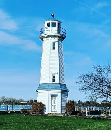
1871 (station established 1825). Inactive since 1901; charted as a landmark. 45 ft (14 m) square cylindrical limestone tower with lantern and gallery, attached to 2-1/2 story limestone keeper's house, which remained in service as the keeper's house for Sodus Outer Light. A 4th order Fresnel lens has been mounted in the tower since 1984, and a fog bell is displayed on the grounds. Tower unpainted, lantern and gallery painted black. Donna Robinson's photo is seen at the top of this page, Anderson has a great page for the lighthouse, Loren Wise has a 2022 photo, Anne-Beth Heijnen also has a 2022 photo, and Google has a street view and a satellite view. This lighthouse is very similar to the classic "schoolhouse" lighthouses of the upper Great Lakes. The keeper's house, expanded by a 2-story frame addition in 1900, remained in service as the keeper's house for Sodus Outer Light. Used for Coast Guard housing until 1980, the station was transferred to the Village of Sodus Bay by Congress in 1984. The lighthouse is now a museum operated by the Sodus Bay Historical Society. The grounds are a 4-acre (1.6 ha) public park used for concerts on Sunday afternoons in the summer. Located on the lakeshore off NY 14 in Sodus Point. Site open year-round, museum and tower open daily except Mondays May through October. Owner: Village of Sodus Point. Site manager: Sodus Bay Lighthouse Museum . ARLHS USA-766.
* Sodus Outer (Sodus Bay West Pier) (2)
1938 (station established 1901). Active; focal plane 51 ft (15.5 m); white light, 3 s on, 3 s off. 49 ft (15 m) square cast iron tower with lantern and gallery, mounted on concrete and stone pier; solar-powered lens. Tower painted white; lantern has a red roof. The old Sodus Bay Light served as the keeper's quarters. Cathy Contant's photo is at right, Anderson has a fine page for the lighthouse, Penberthy has a page for the lighthouse, Kern Lim has a 2021 photo, Bash has a closeup photo, Marinas.com has aerial photos, and Google has a satellite view and a distant street view. This lighthouse replaced a square wood tower. Located at the Sodus Bay entrance in Sodus Point east of the old Sodus Point light. Accessible by walking the pier. Site open, tower closed. Owner/site manager: U.S. Coast Guard. ARLHS USA-765; USCG 7-2170.
Sodud Outer Light
USCGC Neah Bay passing Sodus Outer Light, 4 July 2011
Flickr photo copyright Cathy Contant; used by permission

Inland Lighthouses

Chautauqua County: Chautauqua Lake Lighthouses
Chautauqua Lake is a glacial lake, 17 mi (27 km) long and up to 2 mi (3 km) wide, located in far western New York.

*
North Harmony (Stow Ferry) (2)
2018 (station established 1990s). Active; focal plane about 25 ft (7.5 m); continuous white light. 25 ft (7.5 m) octagonal vinyl-clad wood tower with lantern and gallery. Tower painted with red, white and blue horizontal bands. Andy Butler has a 2017 photo of the original lighthouse, which was quite similar to the Mayville lighthouse (next entry), and Google has a satellite view. In 2018 the lighthouse was replaced with a new tower designed and built by local carpentry students and dedicated in memory of the late North Harmony Town Supervisor Sally Carlson. It is known as "The Lady of the Lake Liberty Lighthouse." Located adjacent to the Stow Ferry terminal on the west side of the lake in North Harmony. Site open, tower closed. Owner/site manager: Town of North Harmony.
* Mayville
1990s. Probably inactive; formerly with a focal plane about 30 ft (9 m); continuous white light. 25 ft (7.5 m) octagonal shingle-clad wood tower with lantern and gallery. Kari Wendel has a photo and Google has a street view and a satellite view. Current photos do not show any lens in the lantern. Located behind the Mayville Depot Museum in Lakeside Park in Mayville, at the northern end of the lake. Site open, tower closed. Owner/site manager: Village of Mayville.

Information available on lost lighthouses:

Notable faux lighthouses:

Adjoining pages: North: Southeastern Ontario | East: Central and Northern New York | West: Northwestern Pennsylvania

Return to the Lighthouse Directory index

Checked and revised January 17, 2024. Lighthouses: 26. Site copyright 2024 Russ Rowlett and the University of North Carolina at Chapel Hill.