Lighthouses of the Philippines: Bohol

The Republic of the Philippines (Pilipinas in Filipino) includes more than 7600 islands stretching over 1750 km (1100 mi) of the western Pacific and separating the Philippine Sea on the east from the South China Sea on the west. The largest islands are Luzon at the northern end of the country and Mindanao at the southern end. As of 2020 the population of the country was about 109 million.

The archipelago was a Spanish colony until the Spanish-American War of 1898, which brought the islands under U.S. administration. Japan occupied the islands during World War II (1942-45) and the country became independent shortly thereafter (1946).

The country is divided into 17 regions and subdivided into 81 provinces. This page lists lighthouses in Bohol Province, part of the Central Visayas Region in the central part of the Philippines. Bohol is an island southeast of Cebu and southwest of Leyte. The island is elliptical in shape, about 80 km (50 mi) long east to west and 50 km (30 mi) wide. The population is about 1.4 million. Bohol faces the Bohol Sea to the south and the Camotes Sea to the north; it is separated from Leyte by the Canigao Channel and from Cebu by the Cebu Strait.

Filipino and English are official languages in the Philippines. In Filipino a lighthouses is called a parola; an island is an isla or pulo. Many English maritime terms have been adopted into Filipino, including cape, bay, and port, and the names of historic lighthouses are often retained in their Spanish forms.

Lighthouses in the Philippines are maintained by the Marine Safety Services Command of the Philippine Coast Guard. Notices to Mariners are posted by the National Mapping and Resource Information Agency (NAMRIA).

Many Philippine lighthouses are not well known so better information and photos are always needed.

ARLHS numbers are from the ARLHS World List of Lights. PCG numbers are the Philippines Light List numbers, where known. Admiralty numbers are from volume F of the Admiralty List of Lights & Fog Signals. U.S. NGA List numbers are from Publication 112.

General Sources
Lighthouses in the Philippines
Photos and observations in blog entries by Loyd Martinez.
Online List of Lights - Philippines
Photos by various photographers posted by Alexander Trabas. Photos from this area are by Rainer Arndt.
Lighthouses in the Philippines
Wikipedia article, with links to articles on several of the individual lighthouses.
Spanish Lighthouses of the Philippines
This is the Directory's own list of the Spanish light stations, with notes on their current status.
Lighthouses in the Philippines
Photos by various photographers available from Wikimedia.
World of Lighthouses - Philippines
Photos by various photographers available from Lightphotos.net.
Navionics Charts
Navigation chart information for Bohol.
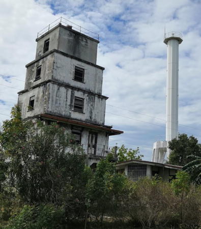

Old and new Balicasag Island Lights, Bohol, April 2019
Google Maps photo by Lidao Li

Bohol Province Lighthouses

South Coast (Bohol Sea) Lighthouses
* Jagna
Date unknown. Active; focal plane 11 m (36 ft) (?); red flash every 5 s. 9 m (30 ft) white concrete post with four buttresses. The light has been raised about 2 m (7 ft) on a skeletal mast to increase its height. Trabas has Arndt's photo and Google has a street view and an indistinct satellite view. Located at the base of the pier in Jagna, a town of about 35,000 residents. Site open, tower closed. PCG-0443; Admiralty F2384; NGA 14876.
Gorda Point
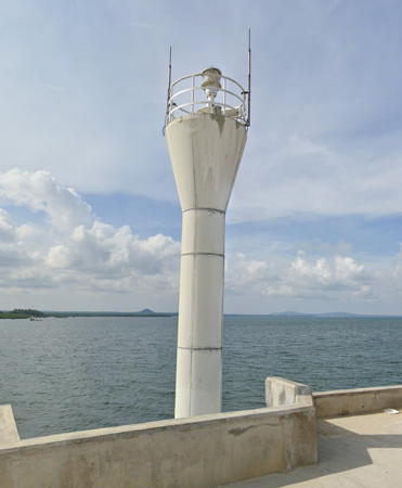
1994. Active; focal plane about 20 m (66 ft); two white flashes every 10 s. Approx. 9 m (30 ft) round barbell-shaped fiberglass tower. Entire lighthouse is white. Google has a street view and an indistinct satellite view. Located on a headland on the southeast coast of Bohol, about 4 km (2.5 mi) east of Valencia. Perched on a steep bluff the lighthouse is not accessible from the highway. Site and tower closed. Admiralty F2383.5; NGA 14875.
* Loay
Date unknown. Active; focal plane 10 m (33 ft); red flash every 5 s. 9.5 m (31 ft) white concrete post with four buttresses. A photo is available and Google has an indistinct satellite view. Located at the base of the pier in Loay, on the east side of the mouth of the Loboc River. Site open, tower closed. PCG-0468; Admiralty F2382; NGA 14872.
* Baclayon
Date unknown. Active; focal plane 12 m (39 ft); red flash every 5 s. 10 m (33 ft) concrete post with four buttresses. Sometime around 2010 the tower was painted a bright yellow; more recently it has been painted with the top yellow and the rest blue, as seen in the 2018 photo at right. Marcelo Malones's 2015 photo and an August 2013 photo show the yellow. Trabas has Arndt's photo, Julia Sumangil has a good 2008 photo, and Google has a 2016 street view and a distant satellite view. The light is within sight of the historic Baclayon Church, built in 1595, the second oldest church of the Philippines. Located on the pier at Baclayon, on the south coast of Bohol. Site open, tower closed. Admiralty F2380; NGA 14868.
Pamilican Island
1994. Active; focal plane unknown; white flash every 5 s. Approx. 9 m (30 ft) round barbell-shaped fiberglass tower. Entire lighthouse is white. Trabas has Arndt's closeup photo and Google has a fuzzy satellite view. An island about 15 km (9 mi) south southeast of Baclayon, Pamilican is administered by the Baclayon municipality. .Located on the northeast side of the island. Site status unknown. PCG-0278; Admiralty F2383; NGA 14885.

Baclayon Light, Bohol, February 2018
Google Maps photo by Wendel

Southwest Coast (Cebu Strait) Lighthouses
* Balicasag Island (1)
1909 (U.S.). Inactive. 5-story square "stepped" tower, each story smaller than the lower one. No lantern. Lidao Li's photo is at the top of this page, Raphael Navarro has a closeup 2022 photo, Binx Monsod has a 2009 photo, Romulus Rueda has a photo of both Balicasag lighthouses, and Google has a satellite view. This building is called an "old fort" on the 1920 light list. The island is a very well-known scuba diving resort, located off the southwest tip of the much larger Panglao Island off the southwest coast of Bohol. Balicasag is administered as part of the Panglao municipality. Located near the center of the island. Site open, tower status unknown. ARLHS PHI-120.
* Balicasag Island (2)
Date unknown. Active; focal plane 37 m (121 ft); white flash every 7 s. 30 m (98 ft) octagonal cylindrical "Apo Reef" tower on an octagonal platform. Lighthouse painted white. Lidao Li has a 2019 photo and the photo is at the top of this page, David Chiou has a photo, Trabas has Arndt's photo, and Google has a satellite view. The light marks the southern entrance to the Cebu (Bohol) Strait, which separates Cebu and Bohol. Located close to the older tower. Site open, tower closed. ARLHS PHI-067; Admiralty F2374; NGA 14884.
* Tagbilaran Pier
1995. Active; focal plane 15 m (49 ft); red flash every 5 s. Approx. 10 m (33 ft) round barbell-shaped fiberglass tower. Entire lighthouse is white. Google has a street view and an indistinct satellite view. Tagbilaran is the capital of Bohol Province, with a population of about 100,000. It is also an important port and ferry terminal; fast ferries from here connect to ports in Cebu, Negros, and Mindanao. Located on the pier at Tagbilaran, at the southwestern corner of Bohol. Site open, tower closed. Admiralty F2378.8; NGA 14864.9.
* Maribojoc
1987. Active; focal plane 13 m (46 ft); white flash every 5 s. 10 m (33 ft) round barbell-shaped fiberglass tower. Entire lighthouse is white. Patrick Fuertes has a closeup photo, Google has the street view seen at right, and the shadow of the light is seen in Google's satellite view. Located on the pier at Maribojoc, a small port on the southwest of Bohol. Site open, tower closed. Admiralty F2376; NGA 14852.

Maribojoc Light, Bohol, July 2021
Google Maps street view

West Coast (Cebu Strait) Lighthouses
Cabilhao Island (Baluarte Point) (1)
Date unknown. Inactive. Approx. 9 m (30 ft) square concrete tower with an external stairway winding around the tower. Ares Etran has a photo and another photo is available. Fred Umabong's 2009 photo shows the 1-story keeper's house gutted by fire; it has since been rebuilt and opened as the Punta Baluarte Eco-Museum. Cabilhao is an inhabited island in the Cebu Strait off the west coast of Bohol; it is administered by the municipality of Loon. Located on the northwest point of the island. Site open, tower closed.
Cabilhao Island (Baluarte Point) (2)
1985. Active; focal plane 10 m (33 ft); white flash every 5 s. 9 m (30 ft) concrete tower. Ares Etran has a photo, John Maye Mayuman has a 2019 closeup, Jungyu Choi has a view from the sea, and Google has a satellite view. This light marks a narrow passage in the Cebu Strait separating Bohol and Cebu. Located in the historic light station. Site open, tower closed. PCG-0270; Admiralty F2375; NGA 14880.
* Catagbacan
Date unknown. Active; focal plane about 12 m (39 ft); green flash every 5 s. Approx. 9 m (30 ft) square concrete tower with an external stairway winding around the tower. A photo is available and Google has a distant satellite view. Catagbacan is a village in the lee of Cabilhao Island and a terminal for ferries from Argao in Cebu; like Cabilhao Island it is administered by the municipality of Loon. Located on the pier at Catagbacan. Accessible by walking the pier. Site open, tower closed. PCG-0269; Admiralty F2387.5; NGA 14862.
* Pangangan Island (Magtung Point)
Date unknown. Active; focal plane about 10 m (33 ft); white flash every 5 s. Approx. 9 m (30 ft) square concrete tower rising from a rectangular open shelter. A distant street view is available and Google has a satellite view. Pangangan is a resort island about 8 km (5 mi) northeast of the Cabilhao Island; it is adminsitered by the muncipality of Calape. Located on a reef off the northwest point of the island. Site open, tower closed. PCG-0525; Admiralty F2375.5; NGA 14879.6.
Bagambanua (Bagong Banua) Island (2)
2002. Active; focal plane about 15 m (49 ft); three white flashes every 15 s. Approx. 12 m (39 ft) round barbell-shaped fiberglass tower. Entire lighthouse is white. Lightphotos.net has a view from the sea and Google has a satellite view. Located on a small island well out into the Cebu Strait, marking the start of the approach to Tubigon. Accessible only by boat. Site status unknown. PCG-0271; Admiralty F2387.6; NGA 14879.
* Tubigon
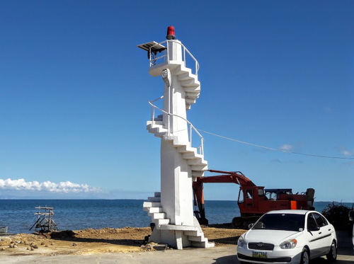
Date unknown. Active; focal plane about 11 m (36 ft); red flash every 5 s. Approx. 9 m (30 ft) square concrete tower with an external stairway winding around the tower. A 2016 photo is at right, a closeup photo is available, the light is behind a crane in Google's street view, and Google has an indistinct satellite view. Tubigon is a city of about 50,000 residents on the northwest coast of Bohol, connected by frequent fast ferries to Cebu City. Located on the pier at Tubigon. Site open, tower closed. PCG-0268; Admiralty F2387; NGA 14860.
* Inabanga (Tungod)
Date unknown. Active; focal plane about 12 m (39 ft); two red flashes 3 s. Approx. 12 m (39 ft) round barbell-shaped fiberglass tower. Entire lighthouse is white. Google has a street view and an indistinct satellite view. Located on the pier at Inabanga, a small city of about 45,000 residents on the northwest coast of Bohol. Site open, tower closed. PCG-0267; Admiralty F2387.7; NGA 14861.

Tubigon Light, Bohol, July 2016
ex-Google Plus photo by El Viajero joven

North Coast (Camotes Sea) Lighthouses
* Getafe (Jetafe)
Date unknown. Active; focal plane 11 m (36 ft); red flash every 5 s. Approx. 9 m (30 ft) square concrete tower with an external stairway winding around the tower. A photo is at right another closeup photo is available, Mark Anthony Grantos has a photo, Mark Winston has a view from the sea, and Google has an indistinct satellite view. This light guides ferries arriving from Cebu City. Located on the pier at Getafe, a town of about 30,000 residents on the north coast of Bohol. Site open, tower closed. Admiralty F2386; NGA 14856.
Jandayan
Date unknown. Active; focal plane about 12 m (39 ft); three white flashes every 10 s. 10 m (33 ft) round barbell-shaped fiberglass tower. Entire lighthouse is white. No photo available but Google has a distant satellite view. PCG applies the Admiralty number F2386 to this light instead of the Getafe light. Located at the southwestern tip of Jandayan Island, separted from Getafe by a narrow strait. Site status unknown. PCG-0643.
Tambu (Tambo) Island
1993. Active; focal plane unknown; two red flashes every 5 s. Approx. 10 m (33 ft) round barbell-shaped fiberglass tower. Entire lighthouse is white. No photo available but Google has a satellite view. This island was for sale in 2019. Located on a small island about 10 km (5 mi) northwest of Talibon. Site open, tower closed. Admiralty F2385.3; NGA 14878.
* Talibon
Date unknown. Active; focal plane about 10 m (33 ft); white flash every 5 s. Approx. 9 m (30 ft) square concrete tower with an external stairway winding around the tower. Jonas Alcoriza has a 2016 photo (lighthouse near the right edge) and Google has a closeup street view, but the light is hard to find in Google's satellite view. Located at the base of the pier at Talibon, a town and ferry terminal on the north side of Bohol. Site open, tower closed. Admiralty F2385; NGA 14877.8.
Bungan
Date unknown. Active; focal plane unknown; white flash every 8 s. Approx. 10 m (33 ft) concrete mast rising from a 1-story structure supported by piles. Regina Tangcoy has a 2023 photo and Bing has a satellite view. Jam David's photo probably shows the same structure although is tagged with a different location. The light guides ships on the channel through the reefs to Talibon. NGA lists it as "Talbon Bohol." Located about 20 km (13 mi) north of Talibon. Accessible only by boat. Site open, tower closed. PCG-0541; Admiralty F2385.7; NGA 14877.6.

Getafe Light, Bohol, October 2019
Google Maps photo by Cinnamoroll Puff
* Ubay
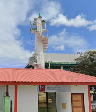
Date unknown. Active (perhaps reactivated); focal plane unknown; green flash every 3 s. Approx. 8 m (26 ft) concrete post with an external stairway spiralling around the post. A closeup photo is available, Trabas has Arndt's closeup, and Google has a street view (also seen at right) and an indistinct satellite view. Ubay is a city of about 80,000 residents on the northeastern tip of Bohol and the terminal for ferries connecting Bohol to several ports in Leyte. Located at the base of the pier at Ubay. Site open, and the tower can probably be climbed. Site open, tower closed. PCG-0264; Admiralty F2384.4; NGA 14877.3.

East Coast (Canigao Channel) Lighthouses
Tood Island (2?)
Date unknown. Active; focal plane 9 m (30 ft); three white flashes every 15 s. 9 m (30 ft) white tower on a square platform supported by piles. Trabas has Arndt's photo and Google has a distant satellite view. This light marks the west side of the Canigao Channel, the strait that separates Leyte from Bohol and connects the Bohol Sea to the Camotes Sea. NGA lists a 5 m (17 ft) "metal structure." Located at the eastern end of the Danajon Bank, a long coral reef off the northeast coast of Bohol. Accessible only by boat. Site open, tower closed. Admiralty F2435.5; NGA 14954.
Tugas Point
Date unknown. Active; focal plane unknown; white flash every 5 s. Approx. 10 m (33 ft) round barbell-shaped fiberglass tower. Entire lighthouse is white. Trabas has Arndt's photo and Google has a satellite view. This light marks the southern entrance to the Canigao Channel. Located on a headland at the northeast tip of Lapinig Island, in the municipality of President Carlos P. Garcia, off the extreme northeastern corner of Bohol; from this point it is about 15 km (9 mi) across the Canigao Channel to Leyte. Site open, tower closed. PCG-0263; Admiralty F2384.6; NGA 14877.
* Talisay
1994. Active; focal plane unknown; three white flashes every 8 s. Approx. 10 m (33 ft) round barbell-shaped fiberglass tower. Entire lighthouse is white. Google has a satellite view and a distant street view. Located on a headland at Anda on the southeastern corner of Bohol. Site open, tower closed. PCG-0282; Admiralty F2384.3; NGA 14876.5.

Ubay Light, Bohol, November 2022
Google Maps street view

Information available on lost lighthouses:

Notable faux lighthouses:

Adjoining pages: Northeast: Leyte and Biliran | South: Northern Mindanao | West: Negros | Northwest: Cebu

Return to the Lighthouse Directory index | Ratings key

Posted July 24, 2005. Checked and revised November 27, 2023. Lighthouses: 24. Site copyright 2023 Russ Rowlett and the University of North Carolina at Chapel Hill.