Lighthouses of the Philippines: Leyte and Biliran

The Republic of the Philippines (Pilipinas in Filipino) includes more than 7600 islands stretching over 1750 km (1100 mi) of the western Pacific and separating the Philippine Sea on the east from the South China Sea on the west. The largest islands are Luzon at the northern end of the country and Mindanao at the southern end. As of 2020 the population of the country was about 109 million.

The archipelago was a Spanish colony until the Spanish-American War of 1898, which brought the islands under U.S. administration. Japan occupied the islands during World War II (1942-45) and the country became independent shortly thereafter (1946).

The country is divided into 17 regions and subdivided into 81 provinces. This page includes lighthouses of three provinces, Biliran, Leyte, and Southern Leyte, including the large island of Leyte and the smaller islands of Biliran to the north and Panaon to the south. These islands are included with the neighboring island of Samar in the Eastern Visayas Region. Historically Leyte Province covered all three islands. Southern Leyte became a separate province in 1960 and Biliran became a province in 1992.

Filipino and English are official languages in the Philippines. In Filipino a lighthouses is called a parola; an island is an isla or pulo. Many English maritime terms have been adopted into Filipino, including cape, bay, and port, and the names of historic lighthouses are often retained in their Spanish forms.

Lighthouses in the Philippines are maintained by the Marine Safety Services Command of the Philippine Coast Guard. Notices to Mariners are posted by the National Mapping and Resource Information Agency (NAMRIA).

Many Philippine lighthouses are not well known so better information and photos are always needed.

ARLHS numbers are from the ARLHS World List of Lights. PCG numbers are the Philippines Light List numbers, where known. Admiralty numbers are from volume F of the Admiralty List of Lights & Fog Signals. U.S. NGA List numbers are from Publication 112.

General Sources
Lighthouses in the Philippines
Photos and observations in blog entries by Loyd Martinez.
Online List of Lights - Philippines
Photos by various photographers posted by Alexander Trabas.
Lighthouses in the Philippines
Wikipedia article with links to articles on several of the individual lighthouses.
Spanish Lighthouses of the Philippines
This is the Directory's own list of the Spanish light stations with notes on their current status.
Lighthouses in the Philippines
Photos by various photographers available from Wikimedia.
World of Lighthouses - Philippines
Photos by various photographers available from Lightphotos.net.
Navionics Charts
Navigational chart information for Leyte.
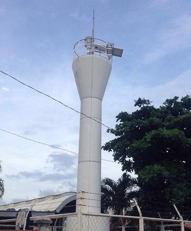

Ormoc Light, Ormoc, Leyte
photo copyright Capt. Peter Mosselberger; used by permission
Biliran Province Lighthouses

Biliran Province Lighthouses
Including several islands in the Samar Sea off the north coast of Leyte, Biliran is one of the newest and smallest provinces of the Philippines; it was separated from Leyte Province in 1992. The main island, also called Biliran, is elliptical, about 30 km (19 mi) long and 20 km (13 mi) wide; since 1975 it has been connected to Leyte by a bridge over the narrow Biliran Strait. The population is about 180,000.
* Mabini (Higatangan Island)
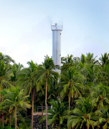
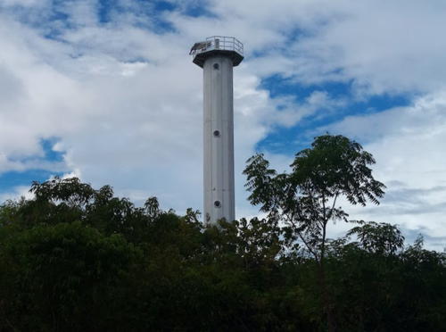
Date unknown. Active; focal plane unknown; white flash every 7 s. Approx. 20 m (66 ft) octagonal cylindrical white metal tower. Miha Pšenica's photo is at right, another photo is available, Elpie Leanda has a 2021 closeup, Rabb Catandijan has a 2022 photo, and Google has a satellite view. In 2021 the service road leading to the lighthouse was paved. Higatangan (or Gigatangan) Island is a small island just off the northwestern tip of Leyte; Mabini is the only village on the island. Despite its proximity to Leyte the island is attached to the municipality of Naval on Biliran. Located near the center of the island. Site open, tower reported open. PCG-0281; Admiralty F2413; NGA 15040.
* Naval (2?)
Date unknown. Active; focal plane about 25 m (82 ft); red flash every 3 s. Approx. 22 m (72 ft) skeletal communications tower. NAMRIA describes the light as being white, but the small light atop the tower in Google's 2021 street view is red and Navionics charts the light as red. This light has always been listed as a "radio tower"; the current tower carries cell and microwave gear and is probably not the original. The tower is seen across the street from the U-shaped building in Google's satellite view. Located at 448 Corvera Street in Naval, the provincial capital, six blocks from the waterfront. Site open, tower closed. PCG-0611; Admiralty F2414.
* Kawayan
Date unknown. Active; focal plane unknown; red flash every 5 s. Approx. 11 m (36 ft) round barbell-shaped white fiberglass tower. No photo available but Google has a satellite view. Located at Kawayan, a port near the northwest corner of Biliran Island. Site open, tower closed. PCG-0476; Admiralty F2415; NGA 15039.
Amambahag Point
Date unknown. Active; focal plane unknown; white flashing light. Approx. 9 m (30 ft) round barbell-shaped white fiberglass tower. No photo available but Google has a satellite view. Located on the northeastern point of Biliran Island. Site status unknown. Admiralty F2415.5.

Mabini Light, Higatangan Island, November 2018
Google Maps photo by Miha Pšenica
 

Leyte Province: North and East Coast Lighthouses

Leyte is a large island southwest of Samar; it is 180 km (110 mi) long and has a population of about 2.4 million. It faces the Camotes Sea to the west, the Samar Sea to the north, and Leyte Gulf to the east. At its southern end it is separated from Mindanao by the Surigao Strait, which connects Leyte Gulf to the Bohol Sea.

North Coast (Samar Sea) Lighthouses
The Samar Sea is a relatively small sea bordering Samar to the east, Masbate to the west, and Leyte to the south. It is connected to the Philippine Sea to the northeast by the San Bernardino Strait, to Leyte Gulf to the southeast by the San Juanico Strait, to the Visayan Sea to the southwest and to the Sibuyan Sea to the northwest.
[Biliran Strait (1)]
Date unknown. Inactive at least since 2016. 9 m (30 ft) white concrete column. The light was reported reactivated in 2016; it was in fact moved to a white mast about 6 m (20 ft) tall as seen in Ma. Lourdes Arce-Ebina's 2018 photo. The small lights do not show in Google's satellite view. The active light is listed with focal plane 11 m (36 ft); white flash every 3 s. Located under the south piers of the Biliran Bridge, on the south side of the west entrance to the narrow Biliran Strait separating Biliran from Leyte. Site open. Active light: PCG-0308; Admiralty F2416; NGA 14888.
* Carigara (2?)
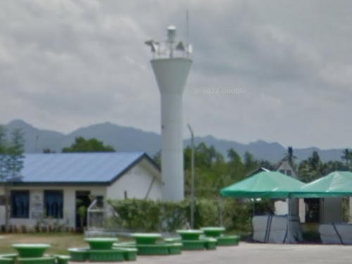
Date unknown. Active; focal plane 9 m (30 ft) (?); green flash every 5 s. 8 m (26 ft) (?) round barbell-shaped white concrete tower. A very distant view is available and Google has a street view (also seen at right) and a satellite view. In the street view the tower appears to be at least 12 m (39 ft) tall. Carigara is a city of about 55,000 residents on the central north coast of Leyte. Founded by Spain in 1569 it is the oldest town of the Eastern Visayas Region. Located at the west end of the waterfront of Carigara adjacent to the municipal government buildings. Site probably open, tower closed. Admiralty F2418; NGA 14892.
Canuay Islet
Date unknown. Active; focal plane 32 m (105 ft); white flash every 5 s. 20 m (66 ft) octagonal cylindrical white metal tower, mounted on a robust stone platform. Gerry Ruiz has a photo (about 1/4 the way down the page) and Bing has a satellite view. Located on an island off Babatñgon marking the western entrance to the San Juanico Strait separating Leyte from Samar, about 40 km (25 mi) northwest of Tacloban. Accessible only by boat. Site status unknown. ARLHS PHI-075; Admiralty F2420; NGA 14908.

Carigara Light, Carigara, August 2016
Google Maps street view
Ivantacut (Ivanticut) Island
Date unknown. Active; focal plane unknown; red flash every 5 s. NGA lists a "concrete structure." No photo available but Bing has a distant and fuzzy satellite view. Located on a tiny island in the San Juanico Strait about 2.5 km (1.5 mi) east northeast of the Canuay Islet light. Accessible only by boat. Site status unknown. Admiralty F2421; NGA 14907.

East Coast (Leyte Gulf) Lighthouses
Leyte Gulf is a wedge-shaped extension of the Philiipine Sea bounded by Samar to the north and Leyte to the west. On the south the Surigao Strait connects the Gulf to the Bohol Sea, and on the north the narrow San Juanico Strait leads to the Samar Sea.

Tacloban
Date unknown. Active; focal plane 16 m (52 ft) (?); red flash every 5 s. Described by NGA as a "white structure on top of building." Jomari John's photo probably shows the light atop the Leyte Park Hotel. If so the listed focal plane is too low. Google has a satellite view of the hotel. This light marks the eastern entrance to the San Juanico Strait. Tacloban is the capital of Leyte Province and the largest city of the Eastern Visayas (Leyte and Samar) with a population of about 250,000. Located near the waterfront of Tacloban. Site status unknown. PCG-0325; Admiralty F2457; NGA 14916.
* Tolosa
Date unknown. Active; focal plane 127 m (417 ft); red flash every 4 s. 3 m (10 ft) square stone or concrete tower atop a ruined stone structure; "concrete tower on fort," according to NGA. The fort, if it was ever a fort, is now a catholic shrine, the Mt. Inapusong Sacred Heart Shrine. Annie Almaden has a photo, Reycel Castro has a photo, Sidsid San Langit has a distant view from below, and Bing has a distant satellite view. Located atop a very steep headland on the east coast of Leyte about 20 km (13 mi) south of Tacloban. Accessible by a short but steep hiking trail beginning near the elementary school in Tolosa. Site open, tower closed. PCG-0324; Admiralty F2455; NGA 14928.
* Abuyog
Date unknown. Active; focal plane 23 m (77 ft); white flash every 5 s. 20 m (66 ft) white octagonal cylindrical tower. A photo is at right and Bing has a satellite view. Located on the north side of the harbor entrance at Abuyog, a city of about 60,000 residents on the east coast of Leyte about 100 km (60 mi) south of Tacloban. Site sprobably open, tower closed. ARLHS PHI-065; PCG-0323; Admiralty F2454.7; NGA 14932.
Abuyog Light
Abuyog Light, Abuyog, Leyte
Municipality of Abuyog photo (no longer online)

Southern Leyte Province Lighthouses

East Coast (Leyte Gulf) Lighthouses
[Silago (Pelada Rock)]
Date unknown. Active; focal plane unknown; two white flashes every 5 s. Approx. 9 m (30 ft) white post. Rusty Wareza has a very distant 2023 view, the light is seen at 1:58 in a YouTube video but it is not seen in Bing's fuzzy satellite view. Located on a small island about 800 m (1/2 mi) offshore and 4 km (2.5 mi) northeast of the town of Silago. Accessible only by boat. Site status unknown. PCG-0846; Admiralty F2424.3.
San Pedro
2008. Active; focal plane 61 m (200 ft); white flash every 5 s. 10 m (33 ft) round barbell-shaped white fiberglass tower on a metal base. No photo available but Bing has a satellite view. Located on San Pedro Island, a tadpole-shaped island in Leyte Gulf about 15 km (9 mi) southeast of Silago. Accessible only by boat. Site status unknown (probably surrounded by private property). PCG-0602; Admiralty F2425; NGA 14932.5.

Cabalian Bay Lighthouses
Cabalian Bay is a broad wedge-shaped inlet of the Surigao Strait indenting the southeastern corner of Leyte Island.

Anahawan (Amagusan Point)
Date unknown. Active; focal plane unknown; white flash every 5 s. Approx. 10 m (33 ft) round barbell-shaped white fiberglass tower. No photo available but Bing has a satellite view. This light marks the western side of the southern entrance to Leyte Gulf from the Surigao Strait and the the northern entrance to Cabalian Bay. Located about 5 km (3 mi) south of Anahawan. Site and tower closed (private property). PCG-0322; Admiralty F2427; NGA 14938.
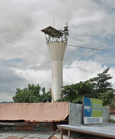
* San Juan (Cabalian) (?)
Date unknown. Active (?); focal plane about 15 m (49 ft); red (?) flash every 5 s. Approx. 11 m (36 ft) round barbell-shaped white fiberglass tower. Google has the 2016 street view seen at right and an indistinct satellite view. The lighthouse is missing in a 2022 Google street view. We need information on the status of the light. NGA has a Biblical error: it lists the light as San Jose instead of San Juan. San Juan (formerly called Cabalian) is a town of about 15,000 residents on the north shore of Cabalian Bay. Located on the town waterfront. Site open, tower closed. Admiralty F2427.2; NGA 14938.5.
Saint Bernard
Date unknown. Active; focal plane unknown; white flash every 5 s. Approx. 11 m (36 ft) white concrete post with a stairway spiraling around the post. The light is seen behind a tree in a 2021 photo and Google has a 2016 street view but the light is not seen in Google's indistinct satellite view of the waterfront. Located in Saint Bernard, a town of about 30,000 residents at the head of Cabalian Bay. Site status unknown. Admiralty F2426.6; NGA 14938.6.

San Juan Light, San Juan, December 2016
Google Maps street view

Panaon Island Lighthouses
Panaon Island is separated by the narrow Panaon Strait from the southeastern tip of Leyte. The island is about 30 km (19 mi) long and averages about 8 km (5 mi) wide. On the east the Surigao Strait separates Panaon from Dinagat Island; the Bohol Sea is to the southwest and Sogod Bay to the northwest. Since 1979 the island has been connected to Leyte by the Liloan (Wawa) Bridge.

Caligangan
Date unknown. Active; focal plane 211 m (692 ft); white flash every 5 s. 9.5 m (31 ft) round barbell-shaped white fiberglass tower. No photo available but Bing has a satellite view. Located atop a sharp cape on the northeast side of Panaon Island, marking the south side of the entrance to Cabalian Bay. Site status unknown. Admiralty F2426.1; NGA 14937.
Binit Point (San Ricardo, Cabutan)
Date unknown. Active; focal plane unknown; four white flashes every 20 s. 20 m (66 ft) octagonal cylindrical white metal tower. No photo available but Google has a distant satellite view. San Ricardo is the terminal for car ferries crossing the Surigao Strait to Surigao City in Mindanao; this is a link in the Eastern Nautical Highway. Located about 2.5 km (1.5 mi) west of San Ricardo on the southern tip of Panaon Island, marking the north side of the Surigao Strait. Site status unknown. PCG-0464; Admiralty F2426.5; NGA 15125.
Ilijan (Napantao) (2?)
Date unknown. Active; focal plane 36 m (118 ft); white flash every 5 s. 10 m (33 ft) round barbell-shaped white fiberglass tower. No photo available but Google has a distant satellite view. Located atop a sharp cape in the village of Napantao on the southwest side of Panaon Island, marking the east side of the entrance to Sogod Bay. Site status unknown. Admiralty F2426.2; NGA 14936.5.
* Liloan Harbor
Date unknown. Active; focal plane 10 m (33 ft); red flash every 5 s. 9 m (30 ft) unpainted concrete post light with a stairway winding around the tower. A view from the sea is available, a blog post has a sunset photo (3/4 the way down the page), and Bing has an indistinct satellite view. Liloan is at the northwestern tip of Panaon Island, west of the bridge connecting Panaon to Leyte. It is a terminal for ferries crossing the Surigao Strait to Mindanao as a link in the Pan-Philippine Highway. Located on a point of land at the west entrance to the harbor. Site open, tower closed. Admiralty F2426; NGA 14936.

Sogod Bay Lighthouses
Sogod Bay is a long inlet of the Bohol Sea separating the southeastern and southwestern peninsulas of southern Leyte.

* Sogod
Date unknown. Active; focal plane about 15 m (49 ft); white flash every 5 s. Approx. 10 m (33 ft) round barbell-shaped white fiberglass tower. A view from the sea is available and Google has a street view (also seen at right) but the tower is hard to find in Bing's fuzzy satellite view. Located at the Public Market on the waterfront of Sogod, a city of about 50,000 residents at the north end of Sogod Bay. Site open, tower closed. PCG-0321; Admiralty F2427.5; NGA 14939.
* Malitbog
Date unknown. Active; focal plane 11 m (36 ft); red flash every 3 s. 9.5 m (31 ft) round barbell-shaped white fiberglass tower. Enrick Rodney Salares has a 2020 closeup street view and Bing has a distant satellite view. Located on the waterfront of Malitbog, a town of about 25,000 residents on the west side of Sogod Bay. Site open, tower closed. PCG-0320; Admiralty F2428; NGA 14940.

Sogod Light, Sogod, November 2016
Google Maps street view

Southwest Coast (Bohol Sea) Lighthouses
Limasawa Island North
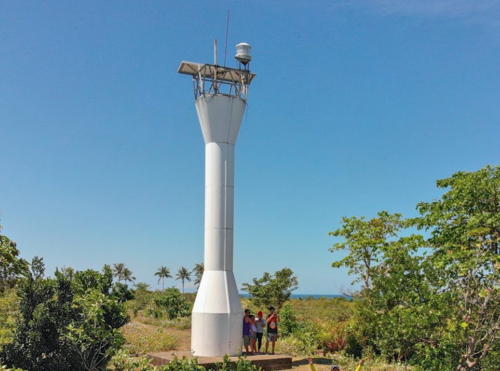
Date unknown. Active; focal plane 39 m (128 ft); two white flashes every 8 s. Approx. 10 m (33 ft) round barbell-shaped white fiberglass tower. Chiez Geralla's photo is at right, Arvin Magaway has a view from the sea, Jobet Romar Gentallan has a closeup, and Google has an indistinct satellite view. The satellite view shows what may be ruins of an older light station. Limasawa is a narrow island in the Bohol Sea, about 10 km (6 mi) long, off the southwestern tip of Leyte at the western entrance to Sogod Bay. The island has about 6000 residents. Located on the northern tip of the island. Site status unknown. PCG-0319; Admiralty F2429; NGA 14944.
Limasawa Island South
Date unknown. Active; focal plane about 39 m (128 ft); two white flashes every 8 s. Approx. 10 m (33 ft) round barbell-shaped white fiberglass tower. A 2023 photo is available, Francis Bitaw Kang has a view from the sea, and Google has a satellite view. Located on the southern tip of Limasawa. Site status unknown. PCG-0731; Admiralty F2429.1.
* Maasin (2)
Date unknown. Active; focal plane 11 m (36 ft); red flash every 5 s. 9 m (30 ft) unpainted concrete post light with a stairway winding around the tower. Trabas has Rainer Arndt's closeup, Google has a street view, and Bing has an indistinct satellite view. Maasin, the capital of Southern Leyte Province, is a port facing the Bohol Sea on the southwestern peninsula of Leyte; it has about 90,000 residents. Located at Espina and Demeterio Streets on the waterfront of Maasin. Site open, tower closed. Admiralty F2430; NGA 14948.

Limasawa Island North Light, Limasawa, March 2019
Google Maps photo by Chiez Geralla

Leyte Province: West Coast Lighthouses

Camotes Sea Lighthouses
The Camotes Sea is a small sea bordered on the east by Leyte, on the south by Bohol, and on the west by Cebu. It connects to the Bohol Sea to the south and the Visayan Sea to the northwest.
Canigao Island (2)
Date unknown (station established 1915). Active; focal plane 24 m (78 ft); white flash every 5 s. 20 m (66 ft) white octagonal tower. A photo is at right, Larry Villaruel has a photo, Ian Rey Abatayo has a closeup of the top of the tower, Trabas has Rainer Arndt's view from the sea, and Google has a satellite view of the station. The original lighthouse was a 24 m (79 ft) wood skeletal tower. Canigao is an uninhabited island in the Canigao Channel, the strait that separates Leyte from Bohol and connects the Bohol Sea to the Camotes Sea. Most of the island is protected as a nature reserve. Located at the north end of the island. Accessible only by boat. Site status unknown. ARLHS PHI-074; Admiralty F2434; NGA 14952.
Adam Reef
Date unknown. Active; focal plane 11 m (36 ft); white flash every 5 s. 11 m (36 ft) white tower on a square platform supported by piles. Trabas has Rainer Arndt's photo but the reef is not shown in Google's satellite view. Located in the Canigao Strait about 6 km (3.5 mi) west of Canigao Island. Accessible only by boat. Site open, tower closed. Admiralty F2435; NGA 14953.
* Hindang (Tagbibi) (2?)
Date unknown. Active; focal plane 11.5 m (37 ft); green flash every 5 s. 9.5 m (31 ft) round barbell-shaped white metal and fiberglass tower. Google has a 2016 street view through trees and an indistinct satellite view. NGA describes the light as being at the northwest corner of a fort, but there is no fort nearby. Located about 2 km (1.25 mi) south of downtown Hindang, the southernmost town of Leyte Province. Site appears open, tower closed. PCG-0316; Admiralty F2436; NGA 14956.
Canigao Island Light
Canigao Island Light, Leyte
City of Tacloban Tourist Development photo
* Baybay
Date unknown. Active; focal plane 13 m (43 ft); white flash every 5 s. 10 m (33 ft) round white barbell-shaped fiberglass tower. Beloi Velasco has a closeup photo, Lightphotos.net has a photo, and Google has a satellite view and a closeup street view. Located on the waterfront of Baybay, a port city of about 110,000 residents on the west side of Leyte. Site open, tower closed. PCG-0315; Admiralty F2438; NGA 14960.
* Albuera
Date unknown. Active; focal plane 12 m (39 ft); white flash every 10 s. 10 m (33 ft) hexagonal cylindrical white aluminum tower. Julio Irastorza Hermosilla's photo is at right, Lightphotos.net has a photo, June Elumbaring has a 2022 view from the sea, the top of the light is seen in a Google street view, and Bing has a satellite view. Located on the waterfront of Albuera, a townof about 50,000 residents at the southern entrance to Ormoc Bay. Site open, tower closed. PCG-0309; Admiralty F2440; NGA 14976.
* Ormoc
Date unknown. Active; focal plane 13 m (43 ft); white flash every 5 s. 9 m (30 ft) round white hourglass-shaped fiberglass tower. Lightphotos.net has Capt. Peter Mosselberger's photo seen at the top of this page, Russell Fermin has a photo, Trabas has a photo by Capt. Romeo Lucero, and Google has a street view and a satellite view. Ormoc is the largest city on the west side of Leyte, with a population of about 230,000. It faces south on Ormoc Bay, a semicircular inlet of the Camotes Sea. Fast ferries leave twice daily for Cebu City, Cebu. Located on the waterfront of Ormoc at the mouth of the Malbasag River. Site open, tower closed. Admiralty F2442; NGA 14968.
Binabaye (Calunangan Point)
Date unknown. Active; focal plane unknown; two white flashes every 10 s. Approx. 10 m (33 ft) round white barbell-shaped fiberglass tower. No photo available but Google has a distant satellite view. Located on heights near the end of the peninsula framing the west side of Ormoc Bay. Ste status unknown. Admiralty F2442.5; NGA 14970.
Sacay Point (Isabel)
Date unknown. Active; focal plane 10 m (33 ft); red flash every 5 s. 10 m (33 ft) round white hourglass-shaped fiberglass tower. No photo available but Google has a satellite view. Located on a point on the west side of the entrance to Dupon Bay, the harbor of Isabel, a town of about 50,000 residents on Leyte's northwestern peninsula. Site open, tower closed. PCG-0592; Admiralty F2443; NGA 14972.
* Palompon
Date unknown. Active; focal plane 11 m (36 ft); red flash every 5 s. 9 m (30 ft) round white hourglass-shaped fiberglass tower. A photo is available, Google has a street view, and the tower is centered in Google's indistinct satellite view. Palompon, a city of about 60,000 residents, is a ferry terminal facing the Camotes Sea on the northwest coast of Leyte. Ferries depart daily for Bogo and Cebu City, Cebu. Located at the north end of the Palompon waterfront. Site open, tower closed. Admiralty F2444; NGA 14980.

Information available on lost lighthouses:


Albuera Light, Albuera, Leyte, May 2010
ex-Panoramio photo copyright Julio Irastorza Hermosilla

Notable faux lighthouses:

Adjoining pages: North: Samar | South: Caraga | Southwest: Bohol and Siquijor | West: Cebu | Northwest: Masbate

Return to the Lighthouse Directory index | Ratings key

Posted July 24, 2005. Checked and revised November 19, 2023. Lighthouses: 33. Site copyright 2023 Russ Rowlett and the University of North Carolina at Chapel Hill.