Lighthouses of the Philippines: Caraga (Northeast Mindanao)

The Republic of the Philippines (Pilipinas in Filipino) includes more than 7600 islands stretching over 1750 km (1100 mi) of the western Pacific and separating the Philippine Sea on the east from the South China Sea on the west. The largest islands are Luzon at the northern end of the country and Mindanao at the southern end. As of 2020 the population of the country was about 109 million.

The archipelago was a Spanish colony until the Spanish-American War of 1898, which brought the islands under U.S. administration. Japan occupied the islands during World War II (1942-45) and the country became independent shortly thereafter (1946).

Mindanao, the second largest island of the Philippines, occupies the southern end of the archipelago. The island is very irregular in shape; the largest portion is very roughly elliptical extending northeast to southwest and there is also a long curved extension, the Zamboanga Peninsula, on the west. The small islands of the Sulu Archipelago stretch from the end of the Zamboanga Peninsula towards Borneo.

The Philippines is divided into 17 regions and subdivided into 81 provinces. This page lists lighthouses of the Caraga Region at the northeastern end of Mindanao, including the provinces of Agusan del Norte, Dinagat Islands, Surigao del Norte, and Surigao del Sur.

Filipino and English are official languages in the Philippines. In Filipino a lighthouses is called a parola; an island is an isla or pulo. Many English maritime terms have been adopted into Filipino, including cape, bay, and port, and the names of historic lighthouses are often retained in their Spanish forms.

Lighthouses in the Philippines are maintained by the Marine Safety Services Command of the Philippine Coast Guard.

Many Philippine lighthouses are not well known so better information and photos are always needed.

ARLHS numbers are from the ARLHS World List of Lights. PCG numbers are the Philippines Light List numbers, where known. Admiralty numbers are from volume F of the Admiralty List of Lights & Fog Signals. U.S. NGA List numbers are from Publication 112.

General Sources
Lighthouses in the Philippines
Wikipedia article with links to articles on several of the individual lighthouses.
Spanish Lighthouses of the Philippines
This is the Directory's own list of the Spanish light stations, with notes on their current status.
Lighthouses in the Philippines
Photos by various photographers available from Wikimedia.
World of Lighthouses - Philippines
Photos by various photographers available from Lightphotos.net.
Online List of Lights - Philippines
Photos by various photographers posted by Alexander Trabas.
Navionics Charts
Navigation chart for northeastern Mindanao.
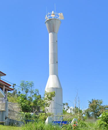

Punta Bilar Light, Surigao, August 2022
Google Maps street view
Agusan del Norte Province Lighthouses
Agusan del Norte has a coast facing northwest on Butuan Bay, an embayment in the southeast corner of the Bohol Sea. Cabadbaran is the provincial capital. The province is named for the Agusan River, the third longest river of the Philippines.

*
Diuata (Diwata) Point
Date unknown. Active; focal plane 20 m (66 ft); white flash every 10 s. 9.5 m (31 ft) round barbell-shaped white concrete tower. Lawrence Baylon has a 2018 photo, Roy Baquial has a closeup, and Google has an indistinct satellite view. This lighthouse stands on the grounds of the Point Diwata Cave Resort. Located on the tip of the peninsula separating Gingoog and Butuan Bays. Site open, tower closed. PCG-0610; Admiralty F2253.9; NGA 15124.5.
Nasipit Harbor Head
Date unknown. Active; focal plane 29 m (95 ft); white flash every 6 s. Approx. 14 m (46 ft) round barbell-shaped white concrete tower. A 2013 photo is available and Google has a satellite view of the light. With a population of more than 40,000 Nasipit is the principal port and ferry terminal for Agusan del Norte Province. Located on a bluff on the west side of the entrance to Nasipit Harbor, a deep inlet at the head of Butuan Bay. There should be a good view from ferries arriving in Nasipit from Bohol and other locations across the Bohol Sea. Note: NGA has confused this light with the next entry. Site status unknown. PCG-0704; Admiralty F2257.5.
Nasipit Harbor
Date unknown. Active; focal plane 20 m (66 ft); green flash every 5 s. 10 m (33 ft) white concrete tower. A short YouTube video has a drone view, the top of the lighthouse is seen in a 2023 Google street view, and Google has an indistinct satellite view. There should be a good view from ferries arriving in Nasipit from Bohol and other locations across the Bohol Sea. NGA appears to have confused the two Nasipit lights, listing the focal plane of the Nasipit Harbor Head Light for this light and also describing the light as white rather than green. Located atop a very steep bluff on the west side of the inlet leading to Nasipit. Site status unknown. PCG-0350; Admiralty F2258; NGA 15116.
Masao (Butuan)
Date unknown. Active; focal plane about 13 m (43 ft); red flash every 5 s. Approx. 11 m (36 ft) round barbell-shaped white concrete tower. Emily Vergara has a photo and Google has a satellite view and a street view through trees. This light is in Butuan, the former provincial capital and metropolis of northeast Mindanao; the city has a population of about 375,000. Located on a hillside above the pier at the Masao Port, on the south side of the entrance to the Agusan River. Site status unknown. PCG-0779; Admiralty F2257.
Agusan River (Magallanes)
Date unknown. Active; focal plane 11 m (36 ft); red flash every 5 s. 11 m (36 ft) concrete tower, probably with a stairway spiraling around the tower. No photo available but Google has an indistinct satellite view. The light serves as a leading light for vessels entering the Agusan River and the port of Magallanes on the north side of the mouth of the Agusan River. Located in the swampy river delta opposite the southern tip of the city. Site status unknown. PCG-0349; Admiralty F2256; NGA 15120.
* Cabadbaran (2)
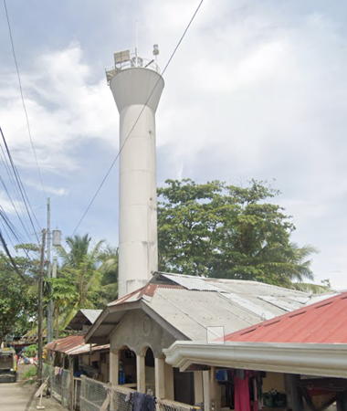
Date unknown. Active; focal plane 20 m (66 ft); green flash every 5 s. 20 m (66 ft) white round hourglass-shaped tower. A photo is available and Google has a street view (also seen at right) and an indistinct satellite view. The original light had a focal plane of 10 m (33 ft). NGA lists the light with a white flash every 7 s; the light was changed to green in 2016. Cabadbaran is a city of about 75,000 residents and the capital of Agusan del Norte province. Located on the south side of the river entrance at Cabadbaran. Site open; tower closed. PCG-0348; Admiralty F2254; NGA 15124.

Cabadbaran Light, Cabadbaran, August 2022
Google Maps street view

Western Surigao del Norte Province Lighthouses
Surigao del Norte occupies the northern tip of Mindanao and several islands offshore to the east, separated from the maniland by the Hinatuan Passage. Surigao City is the provincial capital and a city of about 170,000 residents.
Punta Beach (Malimono)
Date unknown. Active; focal plane unknown; white flash every 10 s. 10 m (33 ft) round barbell-shaped white steel and fiberglass tower. No photo available but Google has a fuzzy satellite view that probably shows the lighthouse. Located on a west-facing beach at Malimono, about 50 km (30 mi) south of Surigao. Site probably open, tower closed. PCG-0616; Admiralty F2253.8; NGA 15125.5.
* Punta Bilar (Bilaa)
Date unknown (2009?). Active; focal plane unknown; white flash every 10 s. Approx. 15 m (49 ft) round white fiberglass tower, flared at the top and bottom. A Google street view is at the top of this page, another photo is available, Simon Cornelius P. Umacob has a photo, Michael Denne has a view from the sea, and Google also has a satellite view. The light is across the street from the Battle of Surigao Strait Memorial and Museum, which memorializes the World War II battleship engagement of 25 October 1944. Located on heights above Punta Bilaa (now called Punta Bilar in most references), the northernmost tip of Mindanao, about 15 km (9 mi) northwest of Surigao city. Accessible by road. Site open, tower closed. . PCG-0775; Admiralty F2251.
Sumilon Island
Date unknown. Active; focal plane unknown; three white flashes every 15 s. Approx. 13 m (43 ft) round barbell-shaped white steel and fiberglass tower. No photo available but Google has a satellite view. There is a much better known Sumilon Island in Cebu Province. Located on a small island in the Surigao Strait about 10 km (6 mi) north of Punta Bilaa. Accessible only by boat. Site status unknown. PCG-0400; Admiralty F2252; NGA 15126.
* Surigao
Date unknown. Active; focal plane about 12 m (39 ft); two red flashes every 5 s. Approx. 9 m (30 ft) white concrete post on a pyramidal base, with a stairway spiralling around the post; a mast has been added atop the tower to raise the height of the light. A photo is at right, Google has a street view, and Bing has an indistinct satellite view. In early 2021 the light was relocated a short distance to the edge of the quay so that a building could be built on its site. A 2013 photo and Google's 2016 street view show the light at the old location. The provincial capital of Surigao City has a population of about 170,000. Located at the foot of Reyes Street on the waterfront of Surigao City. Site open, tower closed. PCG-0403; Admiralty F2250; NGA 15128.
Rasa (Raza) Island
Date unknown. Active; focal plane unknown; three white flashes every 10 s. Approx. 10 m (33 ft) mast centered on a square equipment shelter, mounted on a platform supported by piles. A photo is available and Bing has an indistinct satellite view. Rasa Island lies off the southern tip of Dinagat Island and marks a turn in the narrow Dinagat Strait. Located on shallows off the south side of the island. Accessible only by boat. Site open, tower closed. PCG-0401; Admiralty F2248; NGA 15132.

Surigao Light, Surigao City, June 2021
Google Maps photo by Jayson

Dinagat Islands Province Lighthouse
Dinagat is an island off the northeastern tip of Mindanao and on the east side of the Surigao Strait. The island is about 100 km (60 mi) long and up to 30 km (19 mi) wide. The province, consisting of Dinagat Island and nearby smaller islands, has a population of about 125,000. Formerly part of Surigao del Norte Province, it became a separate province, one of the smallest in the Philippines, in 2006.
Kanhinaud (San José)
2013. Active; focal plane unknown; white flash every 5 s. Approx. 15 m (49 ft) round barbell-shaped white steel and fiberglass tower. No photo definitely available but Google has a distant satellite view and Bing also has a fuzzy satellite view. A tentatively identified ("Dinagat Lighthouse?") photo probably shows this lighthouse. Located on a promontory about 3 km (2 mi) southwest of San José, the provincial capital. Site status unknown. Admiralty F2247.8.
Kanihaan Island
Date unknown. Active; focal plane 18 m (59 ft); white flash every 7 s. 10 m (33 ft) round barbell-shaped white steel and fiberglass tower. No photo available but Bing has a satellite view that probably shows the lighthouse. Located on an island off the central west coast of Dinagat Island. Site status unknown. PCG-0608; Admiralty F2252.5; NGA 14935.7.
Kanhandon Point (Hibuson Island)
Date unknown. Active; focal plane 14 m (46 ft); white flash every 10 s. 9.5 m (31 ft) round white barbell-shaped aluminum and fiberglass tower. No photo available but Bing has an indistinct satellite view. Located on the northwestern tip of Hibuson Island, where it marks the south side of the northern entrance to the Surigao Strait. Site open, tower closed. PCG-0609; Admiralty F2252.7; NGA 14933.
Loreto
Date unknown. Active; focal plane 10 m (33 ft); red flash every 5 s. 10 m (33 ft) square concrete post mounted on a round concrete pier; a stairway spirals around the post. A photo is at right, Ricks Cua has a photo, and Google has a satellite view. Located in the harbor of Loreto on the northwestern coast of Dinagat Island. Accessible only by boat. Site open; there's no impediment to climbing the stairs. Admiralty F2253.5; NGA 14935.5.
Capintac (Kampintak, Dinagat Island)
Date unknown. Active; focal plane unknown. Approx. 10 m (33 ft) white concrete tower. No photo available, but Google has a distant satellite view. Located on a promontory near the northern tip of Dinagat Island. Site status unknown. Admiralty F2253; NGA 14935.

Loreto Light, Dinagat Islands, March 2018
Pinterest photo by decyrable

Eastern Surigao del Norte Province Lighthouses
Hinatuan is an island off the southeast end of Dinagat Island. Siargao is a much larger island to the east, separated from Dinagat Island by the Hinatuan Passage. Bucas Grande is a smaller island just off the southern tip of Siargao. The islands have a population of about 100,000 and are accessible by ferry from Surigao.

Hinatuan North
Date unknown. Active; focal plane about 38 m (125 ft); two white flashes every 9 s. 9.5 m (31 ft) round barbell-shaped white fiberglass tower. Dodong Usyot has a view from the sea and Google has a distant satellite view. NGA lists the focal plane as 11 m (36 ft), but from the photos the height of the light is clearly much greater. Located on a promontory at the northwestern tip of Hinatuan Island, marking the eastern entrance to the passage between Dinagat Island and Mindanao. Accessible only by boat. Site status unknown. PCG-0607; Admiralty F2247.6; NGA 15131.
Hinatuan East
Date unknown. Active; focal plane 14 m (46 ft); white flash every 7 s. 9.5 m (31 ft) round barbell-shaped white fiberglass tower. No photo available but Google has an indistinct satellite view. Located on the eastern tip of Hinatuan Island. Accessible only by boat. Site status unknown. PCG-0606; Admiralty F2247.5; NGA 15130.
Lapinigan (Kapujuan Island)
Date unknown. Active; focal plane about 24 m (79 ft); white flash every 5 s. Approx. 13 m (43 ft) round conctrete tower; a stairway spirals around the post. Elmer Julian has the 2021 photo seen at right, Sahara Laureanne Gallego has a 2020 closeup, and Google has a satellite view. Located on the rock called Kapujuan Island, just off the east end of Lapinigan Island and about 8 km (5 mi) east of the town of Claver on the mainland of Mindanao. Accessible only by boat. Site open, tower closed. PCG-0854; Admiralty F2245.8.

Lapinigan Light, Claver, November 2021
Google Maps photo by Elmer Julian
Halian Island
2016. Active; focal plane about 20 m (66 ft); white flash every 5 s. 12 m (39 ft) square concrete post mounted on a square concrete pier; a stairway spirals around the post. A distant aerial view (second photo on the page) is available and Google has a satellite view. Halian is a small island equidistant from Dinagat Island and Siargao Island. Located on the northern tip of the island. Site status unknown. Admiralty F2247.7.
Punta Alegria (Sugbuhan Point)
Date unknown. Inactive since 2021. Approx. 12 m (39 ft) round white barbell-shaped tower. No photo available but Bing has an indistinct satellite view. Located at the northern tip of Siargao. Site status unknown. ex-Admiralty F2245.5; NGA 15017.
* [Cambas-Ac]
Date unknown. Active; focal plane 10 m (33 ft); white flash every 5 s. Approx. 7.5 m (25 ft) post. The light is on the dark post at the end of the pier on the far left in Jerico Largodizimo's photo of the waterfront, but it is not seen in Google's indistinct satellite view. This light also marks the entrance to the passage leading to Dapa, the principal port of Siargao. Located on the pier in Cambas-Ac. Probably accessible by walking the pier. Site open, tower closed. PCG-0548; Admiralty F2247; NGA 15134.
Dapa
Date unknown. Active; focal plane 10 m (33 ft); white flash every 5 s. 10 m (33 ft) concrete tower with a buttressed base. Dodong Usyot has the closeup photo at right, John Dennis Respicio has a very distant street view from the Dapa Ferry Terminal, and Google has a satellite view. Located on a reef marking a 90° turn vessels must make to approach the Dapa waterfront. Accessible only by boat. Site open, tower closed. PCG-0535; Admiralty F2247.2; NGA 15134.4.

Dapa Light, Bucas Grande, October 2011
Google Maps photo by Dodong Usyot
* [Socorro (2)]
Date unknown. Active; focal plane about 15 m (49 ft); white flash every 5 s. Approx. 7 m (23 ft) square white concrete tower with gallery and a pyramidal base. Lota Constantino Kawazoe has a closeup photo, Miguel Toriaga has a more distant photo, Jose Rey Alo has a street view, and Google has an indistinct satellite view. Located at the base of the pier at Socorro, a town on the east side of Bucas Grande. Site open, tower closed. Admiralty F2246.4; NGA 15135.
Dahakit Point
Date unknown. Active; focal plane 43 m (141 ft); white flash every 5 s. 10 m (33 ft) round barbell-shaped white fiberglass tower. No photo available but Google has a satellite view. Located on the southern tip of Bucas Grande, marking the southern entrance to the Hinatuan Passage. Probably accessible only by boat. Site status unknown. Admiralty F2246; NGA 15136.

Surigao del Sur Province Lighthouses
Surigao del Sur stretches along the northeastern coast of Mindanao, facing the Philippine Sea. Tandag is the provincial capital.

Ayoke (Auqui)
Date unknown. Active; focal plane unknown; three white flashes every 10 s. Approx. 12 m (39 ft) round barbell-shaped white steel and fiberglass tower. Stanley Lopez has a 2018 drone view (a portion is seen at right) and Bing has a distant satellite view. Located on the north end of Ayoke, an island about 15 km (9 mi) northeast of Cantilan. Site status unknown. PCG-0404; Admiralty F2245; NGA 15138.
Cauit Point (1)
1916. Inactive. 10 m (33 ft) square concrete post; a stairway spirals around the post. No photo available but Google has a satellite view (this tower is to the lower right of the new tower). Located on a promontory about 30 km (19 mi) east of Madrid. Site open; there's no impediment to climbing the stairs.
Cauit Point (2)
Date unknown. Active; focal plane 11 m (36 ft); three white flashes every 8 s. Approx. 10 m (33 ft) round barbell-shaped white steel and fiberglass tower. No photo available but Bing has a satellite view. The Bing view does not show the old light, but it may be hidden now by trees. Located on a promontory about 30 km (19 mi) east of Madrid. Site open, tower closed. PCG-0405; Admiralty F2244; NGA 15140.

Ayoke Light, Surigao del Sur, June 2018
Google Maps photo by Stanley Lopez
Mabua (Maboa)
Date unknown. Active; focal plane unknown; two white flashes every 15 s. Approx. 12 m (39 ft) round barbell-shaped white steel and fiberglass tower. No photo available but Bing has a fuzzy satellite view that probably locates the lighthouse. Located on the tip of a promontory on the north side of the entrance to Tandag. Site status unknown. PCG-0406; Admiralty F2243.5; NGA 15142.
Bitaogan Bay (?)
Date unknown. Active; focal plane unknown; white flash every 10 s. No description provided. No photo available but Google has an indistinct satellite view that probably shows the lighthouse. The light guides vessels between reefs in the approach to Cagwait. Located about 2 km (1.25 mi) northeast of the town. Accessible only by boat. Site status unknown. Admiralty F2243; NGA 15145.
Arangasa Island
1916. Active; focal plane 11 m (36 ft); white flash every 5 s. 11 m (35 ft) square concrete post mounted on a square masonry base; a stairway spirals around the post. Jharm Cabatas has a 2021 photo and Google has a satellite view. Located on the beach on the east side of an island about 10 km (6 mi) southeast of Cagwait. Site open; there's no impediment to climbing the stairs. PCG-0408; Admiralty F2242; NGA 15144.
Lianga Bay
Date unknown. Active (?); focal plane unknown; white flash every 5 s. Approx. 10 m (33 ft) square concrete post; a stairway spirals around the post. Philip Cadabuna's photo is at right, Jim de Francia has a photo, a 2020 photo is available, and Google has an indistinct satellite view. Located atop a rock off the waterfront of Lianga. Site open; there's no impediment to climbing the stairs. PCG-0529; Admiralty F2241.
Sanco Point
Date unknown. Active; focal plane 10 m (33 ft); white flash every 5 s. 10 m (33 ft) square concrete post; a stairway spirals around the post. No photo available but Google has a distant satellite view. Located on a prominent cape at the southern entrance to Bislig Bay. Site open; there's no impediment to climbing the stairs. Admiralty F2240; NGA 15146.
Lianga Bay Light
Lianga Bay Light, Surigao del Sur, February 2009
ex-Panoramio photo copyright Philip Cadabuna; permission requested

Information available on lost lighthouses:

Notable faux lighthouses:

  •  

Adjoining pages: North: Leyte | South: Southern Mindanao | West: Northern Mindanao

Return to the Lighthouse Directory index | Ratings key

Posted July 24, 2005. Checked and revised January 28, 2024. Lighthouses: 32. Site copyright 2024 Russ Rowlett and the University of North Carolina at Chapel Hill.