Lighthouses of the Philippines: Romblon and Marinduque

The Republic of the Philippines (Pilipinas in Filipino) includes more than 7600 islands stretching over 1750 km (1100 mi) of the western Pacific and separating the Philippine Sea on the east from the South China Sea on the west. The largest islands are Luzon at the northern end of the country and Mindanao at the southern end. As of 2020 the population of the country was about 109 million.

The archipelago was a Spanish colony until the Spanish-American War of 1898, which brought the islands under U.S. administration. Japan occupied the islands during World War II (1942-45) and the country became independent shortly thereafter (1946).

The Philippines is divided into 17 regions and subdivided into 81 provinces. This page lists lighthouses of a group of islands of the Sibuyan Sea in the west central Philippines, including the provinces of Romblon and Marinduque. The two provinces include the islands of Marinduque, Tablas, Romblon, and Sibuyan as well as many smaller islands, all lying between the larger islands of Masbate to the east, Panay to the south, and Mindoro to the west. The area is part of an administrative region of the country known by the acronym Mimaropa (Mindoro + Marinduque + Romblon + Palawan).

Filipino and English are official languages in the Philippines. In Filipino a lighthouses is called a parola; an island is an isla or pulo. Many English maritime terms have been adopted into Filipino, including cape, bay, and port, and the names of historic lighthouses are often retained in their Spanish forms.

Lighthouses in the Philippines are maintained by the Marine Safety Services Command of the Philippine Coast Guard. Notices to Mariners are posted by the National Mapping and Resource Information Agency (NAMRIA).

Many Philippine lighthouses are not well known so better information and photos are always needed.

ARLHS numbers are from the ARLHS World List of Lights. PCG numbers are the Philippines Light List numbers, where known. Admiralty numbers are from volume F of the Admiralty List of Lights & Fog Signals. U.S. NGA List numbers are from Publication 112.

General Sources
Lighthouses in the Philippines
Photos and observations in blog entries by Loyd Martinez.
Lighthouses in the Philippines
Wikipedia article, with links to articles on several of the individual lighthouses.
Spanish Lighthouses of the Philippines
This is the Directory's own list of the Spanish light stations, with notes on their current status.
Lighthouses in the Philippines
Photos by various photographers available from Wikimedia.
World of Lighthouses - Philippines
Photos by various photographers available from Lightphotos.net.
Online List of Lights - Philippines
Photos by various photographers posted by Alexander Trabas.
Navionics Charts
Navigation chart for the islands.


Apunan Point Light, Romblon, February 2018
ex-Google Plus photo by Hans-Joachim Schnäkel

Romblon Province Lighthouses

Romblon Province includes a group of islands at the southern end of the Sibuyan Sea, south of Marinduque, east of Mindoro, and north of Panay. The principal islands are Sibuyan Island in the east, Romblon Island in the center of the group, and Tablas in the west.

Sibuyan Island Lighthouses
Sibuyan is an isolated, mountainous island known for its unusual plane and animal life. The population is only about 60,000.
Magdiwang
Date unknown. Active; focal plane about 15 m (49 ft); white flash every 5 s. Approx. 10 m (33 ft) white concrete tower. The light is at the far left in Gilbert Villanueva's view from the sea and Google has a fuzzy satellite view. Located on a headland on the east side of the port of Ambulang, a village on the north coast of Sibuyan; ferries link this port to Romblon. Site status unknown. Admiralty F2511; NGA 14594.
* Cajidiocan
Date unknown. Active; focal plane about 12 m (39 ft); two white flashes every 5 s. Approx. 9 m (30 ft) round barbell-shaped white fiberglass tower. Jacques Beaulieu has a photo, Virgil Radan has a view from the pier, and Google has a closeup street view and a satellite view. Located on the beach south of the pier at Cajidiocan, on the east coast of Sibuyan. Site open, tower closed. Admiralty F2513; NGA 14597.
Azagra (Cauit Point (2))
Around 1994. Active; focal plane unknown but at least 45 m (148 ft); two white flashes every 5 s. Approx. 25 m (82 ft) octagonal white aluminum tower. A photo is at right, Sinlao Christopher has a 2021 photo, Ninocelio Rabino has a 2023 view, Google has a distant street view, and Bing has a satellite view. Located on heights above Azagra and about 3 km (2 mi) north of Cauit Point, the southern tip of Sibuyan. Site status unknown. Admiralty F2511.8.
San Fernando (Cauit Point (1))
Date unknown. Active; focal plane of 10 m (33 ft). 10 m (33 ft) white concrete tower with a stairway spiraling around the tower. Ronald Medina has a 2022 closeup photo, Ninocelio Rabino has a 2021 closeup, views from the sea of both Cauit Point lights are available, and Google has a satellite view. Located on the west side of Cauit Point. Site status unknown. . ARLHS PHI-019; PCG-0183; Admiralty F2512; NGA 14596.
Cresta de Gallo Island
Date unknown (2015?). Active; focal plane unknown; white flash every 5 s. Approx. 20 m (66 ft) octagonal white aluminum tower. René Peter has a 2016 aerial photo and Bing has a fuzzy satellite view. Located on an island isolated in the Sibuyan Sea about 16 km (10 mi) southeast of Cauit Point. Accessible only by boat. Site status unknown. Admiralty F2512.5; NGA 14596.5.
 
Cauit Point Light
New Cauit Point Light, Azagra, January 2013
photo copyright islandgirltraveller.com; used by permission
 

Romblon Island Lighthouses
Romblon is a relatively small island, about 20 km (13 mi) long and 6 km (3.5 mi) wide, located between Sibuyan and Tablas. The population is about 75,000.

Port Romblon South (Binagon Point)
Date unknown. Active; focal plane 10 m (33 ft); red flash every 10 s. 10 m (33 ft) square white concrete tower with double gallery. Liezyl Gutierrez has a photo, another photo is available, Google has a distant street view, and Bing has a distant satellite view. According to Navionics NGA has the names of Binagon and Agbatan Points reversed. Located at the north end of a reef projecting from Binagon Point in Romblon hHrbor. Accessible only by boat. Site open; probably nothing prevents climbing on the tower. PCG-0180; Admiralty F2517; NGA 14556.
[Port Romblon North (Agbatan Point)]
Date unknown. Inactive since 2022. 5 m (17 ft) square post on a square platform. Post painted green. Google has a distant street view and a fuzzy satellite view. Located at the west end of a reef on the north side of Romblon Harbor. Site status unknown. ex-PCG-0179; ex-Admiralty F2516; NGA 14552.
* Sabang Point (Punta Corazon) (2?)
Date unknown (station established 1904). Active; focal plane 35 m (115 ft); white flash every 5 s. 5.5 m (18 ft) white concrete tower. The tower is probably centered in Bing's satellite view. Although this station appears to be accessible from the nearby Punta Corazon Resort no photos of it have been found. Site open, tower closed. PCG-0178; Admiralty F2514; NGA 14560.
* Calabago (Calabogo, Calabugo) Point
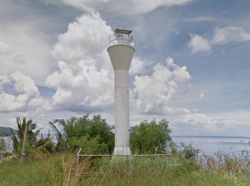
2002(?). Active; focal plane unknown; white flash every 5 s. Approx. 11 m (36 ft) round cylindrical tower with a flared top. Entire lighthouse is white. Google has a closeup street view (also seen at right), Paul Francis Mendez has a 2019 photo, a photo with a brief account of a November 2008 visit is available, and Bing has an indistinct satellite view. Located beside the coastal highway on a promontory on the central east coast of Romblon. Site open, tower closed. PCG-0736; Admiralty F2519; NGA 14550.
* Apunan (Agpanat) Point (2)
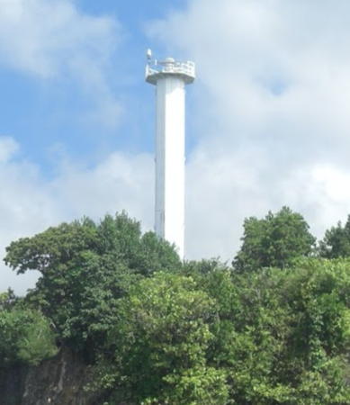
1973 (station established in the 1930s). Active; focal plane 30 m (98 ft); white flash every 10 s. 19 m (62 ft) octagonal white metal tower with gallery. The earlier lighthouse was described by NGA as a "steel framework tower." Hans-Joachim Schnäkel's view from the sea is at the top of this page, Kathrin Hachenberg also has a photo and a view from the sea, and Bing has an indistinct satellite view. Located at the southern tip of Romblon Island. Site open, tower closed. . PCG-0181; Admiralty F2520; NGA 14548.

Calabago Point Light, Romblon, September 2016
Google Maps street view

Tablas Island East Coast Lighthouses
Tablas is by far the largest of the islands in Romblon Province, about 80 km (50 mi) long north to south and about 25 km (15 mi) wide. The northern tip of the island is separated from Romblon by the 15 km (8 mi) wide Romblon Pass; its southern tip is separated from Carabao Island by the 8 km (5 mi) wide Cabalian Channel.
Gorda Point (2?)
Date unknown (station established 1930s?). Active; focal plane 65 m (213 ft); two white flashes every 5 s. 19 m (62 ft) round concrete tower with lantern and gallery, painted white. Keeper's house and other station buildings in ruins. NGA lists this light as a framework tower. James Ricera's closeup photo is at right, Ninocelio Rabino has a 2023 photo, Erwin Apao has a 2018 closeup, Jhay Fornal also has a closeup, a distant view from the sea is available, and Google has an indistinct satellite view of the station. There is another Gorda Point Lighthouse in Bohol. Located on a promontory at the northeastern tip of Tablas Island. Site status unknown. ARLHS PHI-026; Admiralty F2529; NGA 14568.
Biaringan Island
Date unknown. Active; focal plane unknown; two white flashes every 10 s. Approx. 9 m (30 ft) white fiberglass tower. Joey Fabito has a 2022 view of the lighthouse (the light is atop the ridge at upper right) and Google has a distant satellite view. This light marks the entrance to Carmen Bay. Located on an uninhabited island off the northeastern coast of Tablas Island. Accessible only by boat. Site status unknown. PCG-0177; Admiralty F2528.5; NGA 14566.
* Carmen Bay
Date unknown. Active; focal plane 11 m (36 ft); white flash every 3 s. Approx. 9 m (30 ft) concrete post with a stairway spiraling around the tower. No photo available but Bing has an indistinct satellite view. Located just off the beach north of the Carmen Bay pier in northern San Agustin. Site open, tower closed. PCG-0176; Admiralty F2528; NGA 14576.
* San Agustin (Nalumsan Point)
Date unknown. Active; focal plane about 12 m (39 ft); white flash every 5 s. Approx. 10 m (33 ft) hexagonal aluminum post, painted white, mounted on a square concrete pad. A 2017 photo is available and Google has a street view and a satellite view. Navionics charts this as a red light. Located just north of the jetty in San Agustin, the terminal for ferries from Romblon and Sibuyan. Site open, tower closed. PCG-0175; Admiralty F2527.8; NGA 14564.
Calaton Point (Calaton Hill)
Date unknown. Active; focal plane unknown; white flash every 10 s. Approx. 10 m (33 ft) round barbell-shaped white fiberglass tower. No photo available but Bing has a distant satellite view. Located on heights of the heavily forested Calaton Peninsula at the southeastern corner of Tablas Island. Site status unknown. PCG-0174; Admiralty F2527.7; NGA 14593.
Gorda Point Light
Gorda Point Light, Tablas Island, May 2011
ex-Panoramio photo copyright James Ricerra; used by permission

Tablas Island West Coast Lighthouses
Cabalian Point
Date unknown. Active; focal plane 37 m (121 ft); white flash every 5 s. 9 m (30 ft) square white concrete pillar with four ribs, gallery, and a stairway spiraling around the tower. Keeper's house in ruins. No closeup photo available but Google has an indistinct satellite view and the top of the tower is seen above trees in a Google street view. Located at the southern tip of Tablas Island. Site status unknown. Admiralty F2527.6; NGA 14592.
Port Malbog
Date unknown. Active; focal plane 7 m (23 ft); red flash every 5 s. 7 m (23 ft) light atop a square equipment shelter mounted on a concrete pier. Lighthouse painted white. A closeup photo is available and Google has a fuzzy satellite view. A Google street view shows a skeletal tower next to the Port Malbog pier, but we don't know if this tower carries a light. Located at the north end of a reef off the waterfront of Port Malbog, a small fishing port in southern Looc Bay, a broad inlet on the southwest coast of Tablas Island. Accessible only by boat. Site open, tower closed. PCG-0172; Admiralty F2527; NGA 14588.
Looc Reef
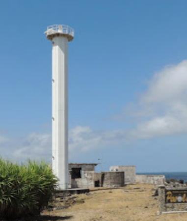
Date unknown. Active (?); focal plane 14 m (46 ft); green flash every 5 s. 14 m (46 ft) slender square concrete tower, with an external concrete stairway winding around the tower, mounted on a square platform supported by four robust concrete piers. A photo is at right, a second photo and a third photo are available, and Google has a satellite view. Looc is the word for bay in the Onhan language spoken in much of Romblon. Located at the north end of a large reef in the harbor of Looc. Accessible only by boat. Site open, tower closed. ARLHS PHI-038; PCG-0467; Admiralty F2526; NGA 14584.
* [Looc Pier]
Date unknown. Active; focal plane about 7 m (23 ft); white (?) light, pattern unknown. Approx. 5 m (16 ft) round white fiberglass (?) tower. Mapio.net has a photo, and Google has a street view and a satellite view. Located on the pier at Looc village, on the north side of Looc Bay. Site open, tower closed. Not listed by the Admiralty.
Guinawayan Point (Ferrol Bay)
Date unknown. Active; focal plane unknown; white flash every 7 s. Approx. 10 m (33 ft) round barbell-shaped white fiberglass tower. No photo available but Google has a distant satellite view. Located on a promontory at the southern entrance to Ferrol Bay on the west side of Tablas Island. Site status unknown. Admiralty F2525; NGA 14582.

Looc Reef Light, Tablas, April 2017
ex-Google Plus photo by Jolly Juls
* Odiongan (Poctoy)
1928. Abandoned but still listed with focal plane 10 m (33 ft); red flash every 5 s. 9 m (30 ft) slender square concrete tower, with an external concrete stairway winding around the tower. A photo is available, Rudy Mariposky has a closeup, and Google has a 2016 street view, and an indistinct satellite view. Clearly trees would hide any light displayed from this tower and a Facebook post describes it as "no longer in use." The light was restored with local contributions in 2007. Odiongan, on the west coast of Tablas, is a major ferry terminal and the largest municipality of Romblon Province, with a population of about 50,000. Located on the waterfront street in Odiongan. Site open, and visitors can climb the stairs of the tower. PCG-0171; Admiralty F2524; NGA 14580.
Poctoy Point (Bantiano Point)
Date unknown. Active; focal plane about 13 m (43 ft); continuous red light. 10 m (33 ft) slender square concrete tower, with an external concrete stairway winding around the tower. No closeup photo available. Kokoy Severino has a photo and a more distant view from the sea, and Google has an indistinct satellite view. Located beside the Sato Dizon Beach Resort, just north of the ferry port on the north side of Odiongan. Site status unknown. PCG-0170; Admiralty F2523; NGA 14578.

Simara Island Lighthouse
Simara Island (Corcuera Point) (2)
Date unknown. Active; focal plane 20 m (66 ft); white flash every 10 s. Approx. 14 m (46 ft) octagonal cylindrical white metal tower. Several nearby buildings may be remains of a historic light station. Arnold Ferrera's photo is at right, Khim Fadallan has a 2018 photo, Ninocelio Rabino has a 2023 photo, Kokoy Severino has a distant view from the sea, Von Ilao has a street view from the beach, and Google has a satellite view. NGA lists a 10 m (33 ft) tower at this location. Located at the western tip of Simara, an island with about 10,000 residents located about 18 km (11 mi) north of Tablas. Site probably open, tower closed. PCG-0168; Admiralty F2530; NGA 14572.

Maestro de Campo Island Lighthouses
Maestro de Campo, also called Sibale, is a small island about 20 km (13 mi) east of Pinamalayan, Mindoro, and 50 km (30 mi) northwest of Tablas. It has about 3500 residents, most living in the town of Concepcion.

Port Concepcion (Batarya Point)
Date unknown. Active; focal plane unknown; red flash every 5 s. Approx. 10 m (33 ft) white concrete or fiberglass tower. No photo available but Google has a satellite view. Located on a promontory on the east side of the entrance to Conception Bay, the harbor of Port Concepcion. Site status unknown. PCG-0167; Admiralty F2531; NGA 14474.
Tunggo Point
Date unknown. Active; focal plane unknown; white flash every 5 s. Approx. 10 m (33 ft) slender square concrete tower, with an external concrete stairway winding around the tower. No photo available but Google has a satellite view . Located on a promontory at the southeast corner of Maestro de Campo (Sibale) island. Accessible only by boat. Site open, tower closed. PCG-0166; Admiralty F2532; NGA 14473.
Mahaba Point
Date unknown. Active; focal plane 10 m (33 ft); white flash every 7 s. 10 m (33 ft) round barbell-shaped white metal and fiberglass tower. No photo available, and apparently dense forest hides the light in Google's satellite view. Located on the western tip of Maestro de Campo. Site status unknown. PCG-0165; Admiralty F2533; NGA 14475.

Corcuera Point Light, Simara Island, April 2018
Google Maps photo by Arnold Ferrera

Marinduque Province Lighthouses

Marinduque is an island about 50 km (30 mi) in diameter at the northern end of the Sibuyan Sea, 50 km (30 mi) northeast of Dumali Point, Mindoro. The island is well populated, with a population of about 240,000.
Baltasar Island (Baltazar Island, Tres Reyes Islands) (2)
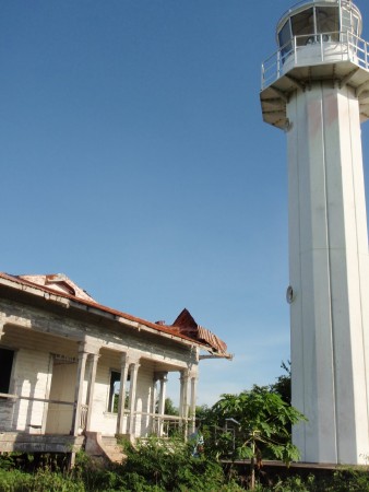
1980s (station established 1906). Active; focal plane 127 m (417 ft); white flash every 10 s. 19 m (62 ft) octagonal cylindrical white metal tower with lantern and gallery. Original 1-story wood keeper's house ifalling into ruins. A photo is at right, Leonilo Guevara Jr. has a 2018 photo, Joven Lilles has a photo, and Google has a satellite view of the station. The original lighthouse, a concrete tower, is said to have been damaged by typhoons. Located on a remote island, outermost of the Tres Reyes (Three Kings) Islands off the southwest coast of Marinduque. Accessible only by boat. Site status unknown. ARLHS PHI-008; Admiralty F2580; NGA 14184.
* Gasan
Date unknown. Active; focal plane 11 m (36 ft); white flash every 10 s. 10 m (33 ft) square concrete pillar with gallery and four ribs. Lighthouse is white with a red band at the base. Google has a good street view and an indistinct satellite view. Located near the ferry terminal in Gasan, on the west coast of Marinduque; ferries arrive here from Pinamalayan, Mindoro. Site open, tower closed. Admiralty F2584; NGA 14188.
Pangi
Date unknown. Active; focal plane about 15 m (49 ft); light characteristic unknown. Approx. 10 m (33 ft) round barbell-shaped white tower. No photo available but Google has a fuzzy satellite view that probably shows the lighthouse. Located just off the beach about 2 km (1.25 mi) north of Gasan. Site status unknown. Admiralty F2585.
* Laylay (Boac)
1906. Active; focal plane 8.5 m (28 ft); red flash every 5 s. 7.5 m (25 ft) square white concrete post with a buttressed base. Florante Lamando has a closeup photo, Mark Raymund Nava has a 2023 photo, and Google has a street view but the small beacon is not clearly visible in Google's satellite view. Located at Laylay on the central west coast of the island. Site open, tower closed. Admiralty F2586; NGA 14192.
Balanacan (Mogpog, Yellow Bluff) (2)
Date unknown (station established 1917). Active; focal plane 14 m (46 ft) (?); two white flashes every 15 s. 8 m (26 ft) white concrete post rising from a pyramidal base. A distant view is available and Bing has a fuzzy satellite view. Balanacan, near the northwestern corner of Marinduque, is located on a sheltered cove and is the terminal for ferries arriving from Mindoro and Luzon. The focal plane of the light appears to be close to 30 m (98 ft) rather than 14 m. Located between Mogpog and Balanacan, on the east side of the cove. Site status unknown. PCG-0087; Admiralty F2588; NGA 14200.
Santa Cruz Harbor
1915. Active; focal plane 7 m (24 ft); white flash every 5 s. 7 m (24 ft) concrete post rising from a pyramidal or buttressed base. No photo available but Google has an indistinct satellite view. The harbor of Santa Cruz, at the northeastern corner of Marinduque, is sheltered by Santa Cruz Island. The light is placed so it acts as a leading light for ships approaching around either end of the island. Located on a reef south of the waterfront of Santa Cruz. Accessible only by boat. Site open, tower closed. PCG-0082; Admiralty F2590; NGA 14204.
Baltasar Island Light
Baltasar Island Light, Marinduque, November 2009
photo by Eli J. from the Marinduque
government's blog, Marinduque Rising

Information available on lost lighthouses:

Notable faux lighthouses:

Adjoining pages: North: Southwest Luzon | Southeast: Panay and Guimaras | West: Mindoro

Return to the Lighthouse Directory index | Ratings key

Posted July 24, 2005. Checked and revised December 30, 2023. Lighthouses: 30. Site copyright 2023 Russ Rowlett and the University of North Carolina at Chapel Hill.