Lighthouses of the Philippines: Mindoro

The Republic of the Philippines (Pilipinas in Filipino) includes more than 7600 islands stretching over 1750 km (1100 mi) of the western Pacific and separating the Philippine Sea on the east from the South China Sea on the west. The largest islands are Luzon at the northern end of the country and Mindanao at the southern end. As of 2020 the population of the country was about 109 million.

The archipelago was a Spanish colony until the Spanish-American War of 1898, which brought the islands under U.S. administration. Japan occupied the islands during World War II (1942-45) and the country became independent shortly thereafter (1946).

Mindoro, the seventh largest island of the Philippines, is roughly 180 km (100 mi) long from northwest to southeast and up to 80 km (50 mi) wide. On the north Mindoro is separated from Luzon by the 25 km (15 mi) wide Verde Island Passage, a very busy seaway. To the southwest the Mindoro Strait separates Mindoro from Palawan Province and provides a wide passage joining the Sulu Sea and the South China Sea. The east side of Mindoro faces the Sibuyan Sea.

The Philippines is divided into 17 regions and subdivided into 81 provinces. Mindoro is part of an administrative region of the country known by the acronym Mimaropa (Mindoro + Marinduque + Romblon + Palawan). The island is divided into two provinces.

Filipino and English are official languages in the Philippines. In Filipino a lighthouses is called a parola; an island is an isla or pulo. Many English maritime terms have been adopted into Filipino, including cape, bay, and port, and the names of historic lighthouses are often retained in their Spanish forms.

Lighthouses in the Philippines are maintained by the Marine Safety Services Command of the Philippine Coast Guard. Notices to Mariners are posted by the National Mapping and Resource Information Agency (NAMRIA).

Many Philippine lighthouses are not well known so better information and photos are always needed.

ARLHS numbers are from the ARLHS World List of Lights. PCG numbers are the Philippines Light List numbers, where known. Admiralty numbers are from volume F of the Admiralty List of Lights & Fog Signals. U.S. NGA List numbers are from Publication 112.
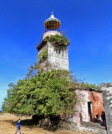

1889 Cabra Island Light, Occidental Mindoro, April 2023
Google Maps street view by Fung Yu
General Sources
Lighthouses in the Philippines
Photos and observations in blog entries by Loyd Martinez.
Lighthouses in the Philippines
Wikipedia article with links to articles on several of the individual lighthouses.
Spanish Lighthouses of the Philippines
This is the Directory's own list of the Spanish light stations with notes on their current status.
Lighthouses in the Philippines
Photos by various photographers available from Wikimedia.
World of Lighthouses - Philippines
Photos by various photographers available from Lightphotos.net.
Online List of Lights - Philippines
Photos by various photographers posted by Alexander Trabas.
Notices to Mariners
Ten years of notices posted by NAMRIA, the Philippines National Mapping and Resource Information Authority.
Navionics Charts
Navigation chart information for Mindoro.

Oriental Mindoro (East Mindoro) Province Lighthouses

Mindoro Northeast Coast (Verde Island Passage) Lighthouses
Varadero Bay (Puerto Galera)
Date unknown. Active; focal plane 26 m (85 ft); green flash every 5 s. 8 m (26 ft) white concrete tower. No photo available but Google has a satellite view. Puerto Galera is a city of about 42,000 residents and the terminal for ferries from Batangas, Luzon. Located on a hillside above the waterfront of Puerto Galera. Site status unknown. PCG-0153; Admiralty F2564; NGA 14460.
Port Galera (2)
Date unknown. Active; focal plane about 20 m (66 ft); red flash every 3 s. NGA lists a 3 m (10 ft) "triangular beacon" but Google's distant satellite view shows the light is now on an approx. 6 m (20 ft) white concrete tower mentioned in October 2020 Notice to Mariners. No closeuo photo available but J.P. Guillerez has a distant drone view. Located on a bluff where it guides ships around a turn in the approach to Puerto Galera, about 3 km (1.8 mi) north of the city. Site status unknown. PCG-0151; Admiralty F2562; NGA 14456.
* Escarceo Point (2)
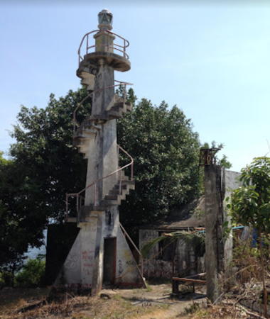
1915 (station estabished 1903). Inactive. Approx. 12 m (39 ft) slender square concrete tower, with an external concrete stairway winding around the tower. No lantern. Keeper's houses and other station buildings in ruins. Alex Kim has the closeup at right, Marj Monces has a second closeup, a photo of the newer light shows the top of the older light, and Google has an indistinct satellite view. This station guides vessels in a passage about 8 km (5 mi) wide between Mindoro and Verde Island. The lighthouse is close to popular beach resorts and is a well-known site for scuba diving. Located a few feet from the modern lighthouse. Site open, external stairway open for climbing.
* Escarceo Point (3)
Date unknown (station estabished 1903). Active; focal plane 41 m (136 ft); white flash every 10 s. 14.5 m (47 ft) octagonal cylindrical tower with gallery. Dan Eddieson Ignacio has a closeup, another photo is available, Marj Monces also has a closeup, and Google has an indistinct satellite view. Located on a headland at the end of a narrow peninsula jutting into the Verde Island Passage about 4 km (2.5 mi) northeast of Puerto Galera. Site open, tower closed. ARLHS PHI-023; PCG-0152; Admiralty F2560; NGA 14452.
* Calapan (?)
Date unknown. Active; focal plane 11 m (36 ft); white flash every 5 s. 7.5 m (25 ft) "white concrete column," according to the light lists. The indicated loaction is on the quay, but no such concrete column is seen in Google's satellite view and none has been found in other views of the port. The provincial capital of Calapan is a city of about 145,000 residents on the northeast coast of Mindoro; it is Mindoro's largest port and a terminal for fast ferries from Batangas, Luzon. Located at the north end of the docks at Calapan. Site status unknown. PCG-0154; Admiralty F2558; NGA 14464.

1915 Escarceo Point Light, Oriental Mindoro, April 2014
Google Maps photo by Alex Kim

Mindoro East Coast (Sibuyan Sea) Lighthouses
Naujan (Santa Cruz)
Date unknown. Active; focal plane unknown; red flash every 5 s. Approx. 10 m (33 ft) round barbell-shaped white fiberglass tower. Google has a street view (a portion is seen at right) but the light is hard to find in Google's fuzzy satellite view. Light lists have the light as Santa Cruz, the name of barangay (ward) in the southern part of Naujan. Located near the waterfront in Naujan, a city of about 110,000 residents on the northeast coast of Mindoro. Site status unknown. PCG-0648; Admiralty F2556; NGA 14466.
Tujud Island (Herrera)
Date unknown. Active; focal plane 46 m (151 ft); white flash every 5 s. 8 m (26 ft) white post with platform. No photo available and the light is not seen in Google's satellite view of the island. Probably this light resembles the Bugol Point Light described below. Light lists have the light as Herrera, the name of a coastal barangay (ward) including the island. Located on an island just offshore about 10 km (6 mi) east of Naujan.. Accessible only by boat. Site status unknown. PCG-0598; Admiralty F2555; NGA 14462.
[Tuntung Point]
Date unknown. Active; focal plane unknown; white flash every 5 s. 3 m (10 ft) white post with platform. No photo available but Google has a satellite view. The focal plane is listed as 3 m (10 ft) but it must be at least 10 m (33 ft). Located on a headland north of the town of Pola. Site status unknown. PCG-0600; Admiralty F2554.5; NGA 14467.
Dumali Point (Ranzo)
Date unknown. Active; focal plane 53 m (173 ft); white flash every 5 s. 19 m (62 ft) cylindrical steel tower with lantern and gallery, painted white. Keeper's house in ruins. A Facebook photo is available, a travel site has two photos, Neil Nava has a very distant view and Google has a distant satellite view. More information is needed on this station. Located on a prominent headland on the east coast of Mindoro about 10 km (6 mi) northeast of Pinamalayan. May be accessible by hiking from nearby resorts. Site status unknown. ARLHS PHI-022; PCG-0155; Admiralty F2554; NGA 14468.

Santa Cruz Light, Naujan, April 2016
Google Maps street view
* Bugol Point (Pili)
Date unknown. Active; focal plane about 15 m (49 ft); red flash every 10 s. Approx. 7.5 m (25 ft) mast rising from a square pyramidal white concrete base; a stairway leads to an observation platform atop the base. Adona Zulueta has a photo, Jillian Mae Tangliben has a photo, and Google has an indistinct satellite view. Located on an islet just off the beach about 8 km (5 mi) northeast of Pinamalayan. Site and observation platform open. Site manager: Magdalena Beach Resort . PCG-0531; Admiralty F2553; NGA 14469.
* Pinamalayan
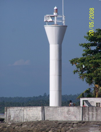
Date unknown. Active; focal plane 11 m (36 ft); red flash every 5 s. 10 m (33 ft) round barbell-shaped white fiberglass tower. Dorie Machan's photo is at right, a view along the beach is available, Jacques Beaulieu has a view from the sea, and Google has a street view and a satellite view. Located on the waterfront in the harbor district of Pinamalayan, a town about 16 km (10 mi) southwest of Dumali Point. Site open, tower closed. PCG-0156; Admiralty F2552; NGA 14476.
* [Guimbunan (Balete)]
Date unknown. Active; focal plane unknown; red flash every 5 s. Approx. 8 m (26 ft) concrete post with a small equipment shelter. Google has a street view and a satellite view. Located on the beach at Balete, about 5 km (3 mi) north of Bansud. Site open, tower closed. PCG-0490; Admiralty F2549.3; NGA 14475.4.
* [Bansud (Bonsod)]
Date unknown. Active; focal plane unknown; white flash every 5 s. Approx. 8 m (26 ft) post atop a small concrete tower. Google has a street view but the small light is inconspicuous in Google's satellite view. Located at the base of the pier in Bansud, a city of about 40,000 residents. Site open, tower closed. PCG-0628; Admiralty F2549.5; NGA 14472.5.
* Bongabong
Date unknown. Active; focal plane 13 m (43 ft); white flash every 10 s. 9 m (30 ft) round barbell-shaped white fiberglass tower. Google has a street view and a satellite view. Located on the waterfront of Bongabong, a village about 50 km (30 mi) south of Pinamalayan. Site open, tower closed. Admiralty F2550; NGA 14472.
* Duyugan (Dayugan) Point
Date unknown. Active; focal plane about 15 m (49 ft); white flash every 10 s. Approx. 12 m (39 ft) round barbell-shaped white fiberglass tower. No photo available but Google has an indistinct satellite view. Located on on a low promontory about 5 km (3 mi) east of Dangay. Site open, tower closed. Admiralty F2551; NGA 14470.
Pinamalayan Light
Pinamalayan Light, Oriental Mindoro, May 2008
ex-Panoramio photo copyright Dorie Machan; used by permission

Occidental Mindoro (West Mindoro) Province Lighthouses

Mindoro Southwest Coast (Mindoro Strait) Lighthouses
The Mindoro Strait is broad passage, roughly 80 km (50 mi) wide, separating Mindoro from the northern islands of Palawan Province. The strait connects the South China Sea (West Philippine Sea) to the Sulu Sea.
Ambulong Island
Date unknown (station established 1907). Active; focal plane 136 m (446 ft); white flash every 5 s. 16 m (52 ft) square skeletal tower with gallery, painted white. No photo available but Google has an indistinct satellite view of the station. This lighthouse marks the southern entrance to the Mindoro Strait. Located on the highest point of Ambulong, an inhabited island off the southern tip of Mindoro. Site status unknown. PCG-0164; Admiralty F2576; NGA 14480.
Caminawit (Caminauit) Point (San José) (2?)
Date unknown. Active; focal plane about 30 m (98 ft); white flash every 5 s. Approx. 27 m (89 ft) triangular skeletal tower at an active Coast Guard station. Google has a street view and a satellite view. NGA lists a 9 m (30 ft) white concrete tower; that light, placed on the beach near the tip of Caminawit Point, does not survive. The city of San José, with a population of more than 150,000, has become the largest port of Mindoro and the light has been moved to the port area sheltered by the point. Located behind the buildings of the San Jose Municipal Fish Port. Site status unknown. Admiralty F2575; NGA 14484.
Apo Reef (2)
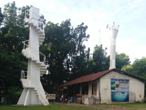
1998 (station established 1906). Active; focal plane 35 m (115 ft); white flash every 10 s. 33.5 m (110 ft) white concrete tower with two galleries; no lantern. The building has an enclosed 2-story square base, an octagonal skeletal section topped by a gallery, and then a square cylindrical section topped by the octagonal second gallery. A photo is at right, another photo is available, there is a good closeup of this remarkable modern lighthouse, Allessandra Runas Tantoy has a sunset photo, Lighthouse Digest has Michael Salvarezza's 2015 article on the light station, Maroun Boutanos has a street view from the beach, and Google has a satellite view of the station. This is one of four lighthouses of this type in the Philippines, including the Lolong Point Light in Southeast Luzon, the Balicasig Island Light in Bohol, and the Nogas Island Light in Panay. Apo Reef is an atoll placed dangerously in the center of Mindoro Strait, the shipping route between the South China Sea and the central and southern Philippines. The atoll is protected as the Apo Reef Natural Park. The original lighthouse here was a 36 m (118 ft) hexagonal skeletal tower with central cylinder; prefabricated in France for the Spanish administration, it was actually built early in the U.S. administration (1906). Wikipedia's page has a photo of that lighthouse and an account of its construction. Note: there is also an Apo Island lighthouse in Negros (see the Negros page). Located on the atoll 40 km (25 mi) southwest of Sablayan. Accessible only by boat. Site open; visitors can climb the stairs to the top of the skeletal section. . ARLHS PHI-002; Admiralty F2574; NGA 14492.
Dongon Point
Date unknown. Active; focal plane about 14 m (46 ft); white flash every 7 s. Approx. 12 m (39 ft) round hourglass-shaped white fiberglass tower. No photo available but Google has a satellite view. Located on a low headland about 20 km (13 mi) south of Sablayan, directly opposite Apo Reef. Site status unknown. Admiralty F2572.
Apo Reef Light
Apo Reef Light
photo copyright Markey Photography
used by reciprocal agreement
* Sablayan Point (1)
Date unknown. Inactive. 11.5 m (38 ft) square concrete tower, painted white, with a small gallery and an external spiral stairway encircling the tower. A photo by Joon Mier da Mienta is at right, Peter Hahn has a 2019 photo, a 2009 photo is available and Google has a satellite view. The neighboring building appears to be a 1-story keeper's house, painted white with a red roof. The grounds of the station, now the Sablayan Parola Park, feature a popular zipline tower. Located on a headland at Sablayan on the west coast of Mindoro, overlooking the Mindoro Strait. Site open; external stairway open for climbing. ARLHS PHI-051.
* Sablayan Point (2)
Date unknown. Active; focal plane 48 m (157 ft); three white flashes every 10 s. 12 m (39 ft) round hourglass-shaped white fiberglass tower. A photo by Joon Mier da Mienta is at right, Don Bustria has a 2022 photo, a 2008 photo and a 2009 photo are available and Google has a satellite view. Located a few feet from the historic beacon. Site open, tower closed. Admiralty F2570; NGA 14488.

Mindoro Northwest Coast (South China Sea) Lighthouses
In the Philippines the South China Sea, or at least that part of it adjoining the Philippines, is known officially as the West Philippine Sea.

* Tubili Point
Date unknown. Active; focal plane unknown; four white flashes every 20 s. Approx. 10 m (33 ft) round barbell-shaped white fiberglass tower. Davidson Valera has a 2019 closeup photo and Google has a satellite view. Located on a promontory about 10 km (6 mi) west of Mamburao. Accessible by road and a walking path, but the entrance is unmarked. Site open, tower closed. PCG-0161; Admiralty F2569; NGA 14450.

Old and new Sablayan Point Lights, Sablayan, August 2018
Google Maps photo by Joon Mier da Mienta
Cape Calavite (2)
Date unknown. Active; focal plane 42 m (137 ft); white flash every 5 s. 19 m (62 ft) steel tower, painted white. No photo available, but Bing has a satellite view. Located in a remote area on the cape at the northwestern corner of Mindoro. Probably accessible only by boat. Site status unknown. Site manager: Mount Calavite Wildlife Sanctuary. ARLHS PHI-016; Admiralty F2568; NGA 14448.

Lubang Islands Lighthouses
The seven Lubang Islands extend northwest from the northwestern tip of Mondoro. The largest island, also called Lubang, is about 25 km (15 mi) long. The islands have a little less than 30,000 residents.

Cabra Island (1)
1889. Inactive. 20.5 m (67 ft) square cylindrical brick tower with lantern and gallery, painted white, attached to a 1-story keeper's house. This deactivated lighthouse still has its original lantern; the 1st order Fresnel lens has been vandalized but prisms remain in the upper portion of the lens. Fung Yu has the 2023 street view seen at the top of this page, a 2022 photo is available, M.J. de Lara has a 2008 closeup photo, Loyd Martinez has a page with photos from his 2014 visit, Julie Gregorio has a 2017 photo, Remo Dandoy has a 2018 photo, Wikimedia has a photo of the two Cabra Island lighthouses, the lighthouse appears on a postage stamp, and Google has a satellite view. Gravely endangered: Manuel Noche found the lighthouse reasonably intact but badly in need of restoration; clearly its condition has continued to deteriorate. Cabra Island is located off the northwestern tip of Lubang Island, an inhabited island at the northwestern corner of Mindoro. The lighthouse was built to mark the western entrance from the South China Sea to the Southern Passage through the center of the Philippine archipelago. In addition, the station is located about 80 km (50 mi) southwest of the entrance to Manila Bay and marks the beginning of the southwestern approach to the capital. Located at the west end of the island. Accessible only by boat. Site open, tower closed. . ARLHS PHI-030.
Cabra Island (2)
Date unknown (station established 1889). Active; focal plane 66 m (216 ft); white light, occulting every 5 s. Approx. 20 m (66 ft) round cylindrical tower, painted white. Fung Yu has the 2023 street view seen at right, Laiza Joy Bool has a 2022 photo, Julie Gregorio has a 2017 photo, and Google has a satellite view. Located about 100 m (110 yd) from the historic lighthouse. PCG-0146; Admiralty F2620; NGA 14256.

New Cabra Island Light, Occidental Mindoro, April 2023
Google Maps street view by Fung Yu
Tilik Bay
Date unknown. Active; focal plane 9 m (30 ft); quick-flashing red light, also a continuous white light. 9 m (30 ft) square concrete tower on piles. Fung Yu has a 2018 drone view and Google has a satellite view. Identified as "Tsunami Obs." by the Admiralty, the tower apparently monitors tidal levels. Located on a shoal in the harbor of Tilik, a small port on the north side of Lubang Island, about 250 m (820 ft) north of the ferry terminal. Accessible only by boat but visible from shore. Site open, tower closed. Admiralty F2618.5.
* Tilik (Tilic, Lubang) (1)
Date unknown. Inactive since 2021. 10 m (33 ft) slender square white concrete tower, with an external concrete stairway winding around the tower. David Hyde has a closeup 2011 photo and additional photos but the slender tower is inconspicuous in Google's indistinct satellite view of the port. Located at the ferry terminal in Tilik. Site open, tower closed.
* Tilik (Tilic, Lubang) (2)
2021. Active; focal plane 24 m (79 ft); red flash every 5 s. Approx. 20 m (66 ft) white steel skeletal tower. Kim Corona has a 2022 photo, Fung Yu has an overhead drone view, and Google has a 2023 street view. This new tower was announced by PCG in a November 2021 Notice to Mariners. Site status unknown. PCG-0147; Admiralty F2618; NGA 14252.
Tanawan Point (Golo Island)
Date unknown. Active; focal plane 57 m (186 ft); white flash every 7 s. 11 m (36 ft) octagonal white concrete tower with gallery. Mabhel Ambrocio has a 2021 photo, Inocenteng Makata has a closeup, and Google has a satellite view. This light marks a narrow passage between the north end of Mindoro and the Lubang Islands. Located at the southeastern tip of Golo, an island southeast of Lubang Island. Site status unknown. Admiralty F2616; NGA 14248.

Mindoro North Coast (Verde Island Passage) Lighthouse
* Wawa (Abra de Ilog) (2?)
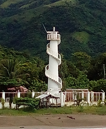
Date unknown. Active; focal plane about 15 m (49 ft); white flash every 5 s. Approx. 13 m (43 ft) round concrete tower with a stairway winding around the tower. Entire lighthouse is white. Rosano Sarne has the 2017 photo at right, Art Torio has a view from the sea, Suzette Flores has a view from the pier, and Google has an indistinct satellite view. Ferries arrive here from Batangas, Luzon. This relatively modern light appears to be northeast of the location of the original light in order to serve a new ferry port. Located near the base of the Abra de Ilog Pier east of Wawa. Site open, tower closed. PCG-0150; Admiralty F2566; NGA 14465.

Information available on lost lighthouses:

  •  

Abra de Ilog Light, Wawa, September 2017
ex-Google Plus photo by Rosano Sarne

Notable faux lighthouses:

Adjoining pages: North: Southwest Luzon | East: Romblon and Marinduque | Southwest: Palawan

Return to the Lighthouse Directory index | Ratings key

Posted July 24, 2005. Checked and revised January 7, 2024. Lighthouses: 28. Site copyright 2024 Russ Rowlett and the University of North Carolina at Chapel Hill.