Lighthouses of Canada: Southern Québec

The nation of Canada was created by the British North America Act in 1867 with Québec as one of the four original provinces, along with Nova Scotia, New Brunswick, and Ontario. Québec is descended from New France, the French empire in North America, which fell to Britain during the Seven Years War (1756-63). Today Québec is the largest of Canada's ten provinces by area and second-largest by population. It retains its French heritage and has French as its official language. The heart of the province is the valley of the St. Lawrence River and Estuary. The St. Lawrence is one of the world's greatest inland waterways: ocean-going ships sail the river to Montréal and many continue on the St. Lawrence Seaway to the Great Lakes.

Québec is divided into 17 administrative regions (régions administratives). Outside of the major urban areas Québec is further divided into 86 county-level regional county municipalities (municipalités régionale de comté). This page covers lighthouses of southern Québec: the part of the Canadian province south of the St. Lawrence River in the administrative regions of Centre-du-Québec and Chaudière-Appalaches.

French is the sole official language in Québec. The French word for a lighthouse, phare, is often reserved for the larger coastal lighthouses; a smaller light or harbor light is called a feu (literally "fire," but here meaning "light") or a balise (beacon). The front light of a range (alignement) is the feu antérieur and the rear light is the feu postérieur. In French île is an island, cap is a cape, pointe is a promontory or point of land, roche is a rock, récife is a reef, baie is a bay, estuaire is an estuary or inlet, détroit is a strait, rivière is a river, and havre is a harbor.

Aids to navigation in Canada are maintained by the Canadian Coast Guard. In 2008 Parliament passed the Heritage Lighthouse Protection Act to designate and protect historic lighthouses.

ARLHS numbers are from the ARLHS World List of Lights. CCG A-numbers are from the Atlantic Coast portion of the List of Lights, Buoys, and Fog Signals of Fisheries and Oceans Canada. Admiralty numbers are from Volume H of the Admiralty List of Lights & Fog Signals. U.S. NGA numbers are from Publication 110.

General Sources
Quebec, Canada Lighthouses
Photos and text, including travel directions, by Kraig Anderson.
Quebec, Canada Lighthouses
Fine aerial photos posted by Marinas.com.
Quebec
Photos of Québec lighthouses taken in 2008 and posted by C.W. Bash.
Lighthouses in Quebec
Photos by various photographers available from Wikimedia.
Online List of Lights - Canada
Photos by various photographers posted by Alexander Trabas. Most of the photos for the St. Lawrence are by Michael Boucher or Alain Garceau..
Lake Memphremagog - Quebec Lighthouses
Information on the lost lighthouses of this lake, located on the Vermont border.
Canada-U.S.: Lake Memphremagog
Historic postcard images posted by Michel Forand.
Leuchttürme Kanadas auf historischen Postkarten
Historic postcard views posted by Klaus Huelse.
List of Lights, Buoys, and Fog Signals
Official Canadian light lists.
GPSNauticalCharts
Navigation chart information for the St. Lawrence.
Navionics Charts
Navigation chart information for the St. Lawrence.


Range Rear Light, Port-Saint-François
photo copyright Michael Boucher; used by permission

Centre-du-Québec Region Lighthouses

Nicolet-Yamaska Municipality Lighthouses
Nicolet Sector (Range Front) (2)
1938 (station established 1907). Active; focal plane 9 m (29 ft); white or green light, 1 s on, 1 s off; white light is shown to the west and green to the east. 9 m (29 ft) trapezoidal cylindrical concrete tower with octagonal lantern; lantern painted with red and white vertical stripes. The upstream side of the light has a sharp "prow" to break ice floes. Yves Lavoie's photo is at right, a closeup and another closeup photo are available, Trabas has Garceau's closeup photo, Lighthouse Digest has a Coast Guard photo, Marinas.com has aerial photos, and Google has a satellite view. Formerly this was the Nicolet Range Front Light, but the rear light of the range was discontinued in 1970. Located on an islet in the river at the east end of the Lac St.-Pierre basin north of Nicolet. Accessible only by boat. Site open, tower closed. Owner/site manager: Canadian Coast Guard. ARLHS CAN-1264; CCG A-2119.5; Admiralty H2400; NGA 4748.
* Port-Saint-François Range Front (2)
1906 (station established 1849). Active; focal plane 11 m (36 ft); continuous green light visible only on the range line. 11 m (36 ft) lantern centered on a huge square pyramidal concrete pier. Lighthouse painted white; lantern roof painted red, and the front of the lighthouse is also painted red with a black vertical stripe. Trabas has Boucher's closeup photo, Stéphanie Arel has a photo, Daniel Berthiaume has a street view, and Google has a satellite view. This is a downstream range guiding vessels leaving Lac St.-Pierre. Located just offshore at Port-Saint-François. Accessible only by boat, but easily seen from shore. Site open, tower closed. Owner/site manager: Canadian Coast Guard. ARLHS CAN-1265; CCG A-2112; Admiralty H2398; NGA 4732.

Nicolet Sector Light, Nicolet, May 2021
Google Maps photo by Yves Lavoie
Port-Saint-François Range Rear (4?)
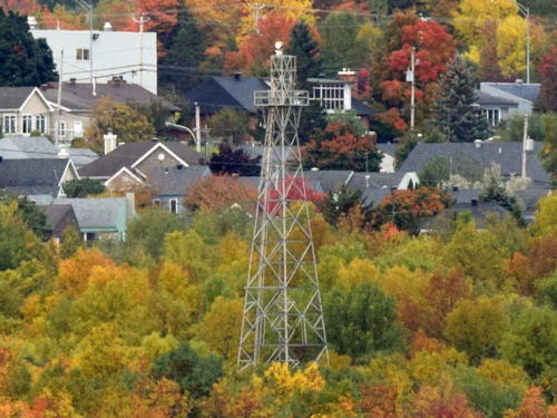
1906 (station established 1860s). Active; focal plane 19 m (62 ft); continuous green light visible only on the range line. 13 m (43 ft) square pyramidal skeletal tower with lantern and enclosed watch room. The tower also carries a leading light (red light, 1 s on, 1 s off; CCG A-2113.1; Admiralty H2398.15) for vessels headed upstream. Tower painted black, watch room white, lantern red; the front face of the watch room is red with a black vertical stripe on the range line. Trabas has Boucher's closeup photo (also seen at the top of this page), Lighthouse Digest has a Coast Guard photo, and Google has a satellite view and a street view of the top of the tower. Located at the end of Rue Duval on the south side of the river at Port-Saint-François, about 8 km (5 mi) north of Nicolet and 1370 m (0.85 mi) northeast of the front light. Site status unknown (very possibly open), tower closed. Owner/site manager: Canadian Coast Guard. ARLHS CAN-1266; CCG A-2113; Admiralty H2398.1; NGA 4736.

Bécancour Municipality Lighthouses
Bécancour Range Rear (2?)
2009 (station established 1904). Active; focal plane 23 m (75 ft); continuous green light visible only on the range line. 17 m (55 ft) square cylindrical skeletal tower. The front of the tower also carries an orange slatted daymark with a vertical black stripe on the range line. This modern light replaced a square pyramidal skeletal tower with lantern and enclosed watch room. Trabas has Garceau's photo and Google has a satellite view. Lighthouse Digest has a 1992 photo of the previous light. Located on a concrete pier just off the south bank of the river about 1.8 km (1.1 mi) west of the front light. Accessible only by boat. Site and tower closed. Owner/site manager: Canadian Coast Guard. ARLHS CAN-1175; CCG A-2074; Admiralty H2384.1; NGA 4592.
Bécancour Range Front (2)
Date unknown (station established 1904). Active; focal plane 7 m (23 ft); continuous green light visible only on the range line. 6.5 m (21 ft) square pyramidal concrete pier topped by an enclosed lantern and gallery; lantern roof painted red. The front of the tower also carries an orange slatted daymark with a vertical black stripe on the range line. Boucher's photo is at right, Trabas has Garceau's photo, Lighthouse Digest has a 1996 photo, and Google has a satellite view. This is an upstream range. The light was originally shown from a hexagonal lantern, and it is not known when the present lantern was installed. Located on the west side of the mouth of the Rivière Bécancour about 8 km (5 mi) southwest of the port of Bécancour. Site status unknown. Owner/site manager: Canadian Coast Guard. ARLHS CAN-873; CCG A-2073; Admiralty H2384; NGA 4588
 

Bécancour Range Front Light, Trois-Rivières
photo copyright Michael Boucher; used by permission
Gentilly Range Rear (3)
Around 2008 (station established 1907). Active; focal plane 31 m (103 ft); continuous green light visible only on the range line. 24 m (79 ft) slender square steel skeletal tower. The tower carries a slatted trapezoidal daymark painted red with a black vertical stripe. The previous light was a 23 m (75 ft) square pyramidal skeletal tower with lantern and enclosed watch room. Trabas has Boucher's photo and Google has a satellite view and a distant street view of the new light. Lighthouse Digest has a 1992 photo of the previous light. Located in a field just north of Bécancour on the south shore of the river. Site status unknown (apparently open). Owner/site manager: Canadian Coast Guard. ARLHS CAN-1261; CCG A-2051; Admiralty H2370.1; NGA 4476.
 
Gentilly Range Front (2)
1920 (station established 1907). Active; focal plane 12 m (39 ft); continuous green light visible only on the range line. 6 m (19 ft) square wood tower with lantern mounted on a square pyramidal concrete pier. Tower painted white, except the front is painted bright orange-red with a black vertical stripe on the range line. Trabas has Boucher's photo, Lighthouse Digest has a closeup photo, and Bing has a satellite view. This is an upstream range. The original light was replaced after being shoved out of position by ice floes. Located in the river north of Gentilly, about 20 km (13 mi) northeast of Trois-Rivières; should be visible from the south shore in the Gentilly area. Accessible only by boat. Site open, tower closed. Owner/site manager: Canadian Coast Guard. ARLHS CAN-952; CCG A-2050; Admiralty H2370; NGA 4472.
* Calvaire Range Front (1) (relocated to Deschaillons)
1915. Inactive since the 1980s. Approx. 7 m (23 ft) square pyramidal wood tower with lantern and gallery, painted white with red trim. A photo is at right, Ali Arabieh has a 2021 photo, Bash has a 2008 photo, Wikimedia has two photos, Lighthouse Digest has Michel Forand's photo, and Google has a street view and a distant satellite view. Anderson has a historic photo of the lighthouse on station. In late 2013 the Deschaillons municipal council voted to spend $35,000 to restore the lighthouse. Located at a roadside park on the south side of the St. Lawrence, beside highway QC 132, about 2 km (1.3 mi) west of Deschaillons-sur-St. Laurent. Site open, tower closed.
Calvaire Range Rear (3)
1994 (station established 1915). Active; focal plane 54 m (177 ft); continuous green light. 20.5 m (67 ft) square skeletal mast carrying a trapezoidal orange slatted daymark with a vertical black stripe. Trabas has Garceau's photo and Google has a satellite view and a very distant street view. Anderson has a historic photo of the original lighthouse. This is an upstream range. Located on a farm 616 m (0.38 mi) southwest of the front light and about 1.6 km (1 mi) southeast of Deschaillons. Site and tower closed (private property). Owner/site manager: Canadian Coast Guard. ARLHS CAN-1114; CCG A-2020; Admiralty H2356.1; NGA 4312.
* [Calvaire Range Front (2)]
1994 (station established 1915). Active; focal plane 40 m (131 ft); continuous green light. 10 m (33 ft) square skeletal mast carrying a trapezoidal orange slatted daymark with a vertical black stripe. Trabas has Garceau's photo, Google has a street view, and Bing has an indistinct satellite view. The Calvaire Range replaced the Cap Charles Range, which was a short distance to the east of the modern front light. The original lighthouse (see above) was relocated to Deschaillons after being replaced in the 1980s by a skeletal tower. Located beside QC 132 about 2 km (1.25 mi) east of Deschaillons. Site open, tower closed. Owner/site manager: Canadian Coast Guard. ARLHS CAN-874; CCG A-2019; Admiralty H2356; NGA 4308.
Phare de Deschaillons
Calvaire Range Front Light, Deschaillons, June 2008
Wikimedia Creative Commons photo by Dana2255

Chaudière-Appalaches Region Lighthouses

Lotbinière Municipality Lighthouses
* [Leclercville (Sainte-Emmélie) Range Front (3)]
2002 (station established 1880). Active; focal plane 37 m (121 ft); continuous green light visible only on the range line. 10 m (33 ft) square skeletal mast carrying a trapezoidal orange slatted daymark with a vertical black stripe. Bash's photo is at right, Trabas has Garceau's photo, and Google has a street view and an indistinct satellite view. This is a downstream range. Anderson has a 1915 photo of the original lighthouse with the second lighthouse under construction. Located beside QC 132 about 2 km (1.2 mi) southwest of Leclercville. Site open, tower closed. Owner/site manager: Canadian Coast Guard. ARLHS CAN-1146; CCG A-2015; Admiralty H2358; NGA 4316.
[Leclercville (Sainte-Emmélie) Range Rear (3)]
Around 2005 (station established 1880). Active; focal plane 57 m (186 ft); continuous green light. 11 m (36 ft) skeletal mast carrying an orange slatted daymark with a vertical black stripe. Bash has a photo of the present light, Trabas has Garceau's photo, and Google has an indistinct satellite view. Anderson has a 1915 photo of the original lighthouse with the second lighthouse, and Lighthouse Digest also has a photo of the 1915 light. Located 1042 m (0.6 mi) east of the front light. Site and tower closed (private property). Owner/site manager: Canadian Coast Guard. ARLHS CAN-1147; CCG A-2016; Admiralty H2358.1; NGA 4320.
* Lotbinière Range Rear (3)
1993 (station established 1871). Active; focal plane 41 m (135 ft)); continuous white light visible only on the range line. 17 m (56 ft) square cylindrical skeletal tower. The lighthouse carries a large triangular daymark, orange with a black vertical stripe, on its upstream face. Trabas has Garceau's photo, Lighthouse Digest has a Coast Guard photo, and Google has a satellite view and a distant street view. This is an upstream range. The original light was on a short wood tower; this was replaced by a skeletal tower in the late 1940s. Located 868 m (0.54 mi) south southwest of the front light. Site and tower closed (private property). ARLHS CAN-1148; CCG A-2007; Admiralty H2348.1; NGA 4232.
* [Lotbinière Range Front (2 and 3)]
2006 (station established 1871). Active; focal plane 15 m (50 ft); continuous white light visible only on the range line. 12.5 m (41 ft) square skeletal mast carrying an orange slatted daymark with a vertical black stripe on the range line. Trabas has Boucher's photo and Google has a 2013 street view and an indistinct satellite view. Lighthouse Digest has a photo of the second (1920) lighthouse, a square skeletal tower with lantern, gallery, and enclosed upper section. Anderson found the enclosed upper section of the historic tower sitting on the ground; this is also seen in Michel Grimard's photo and in the center of another Google street view (the tower on the right is a faux lighthouse). Apparently it is in the possession of the property owner. Located on the south shore of the river west of Lotbinière, near the pier in the village of Vieille-Église. Site and tower closed, but the light can be seen from the Vieille-Église quay. Owner: Canadian Coast Guard. Site manager: private. ARLHS CAN-1149; CCG A-2006; Admiralty H2348; NGA 4228.
Leclercville Range Front Light
Leclercville Range Front Light, Leclercville, June 2008
Flickr Creative Commons photo by C.W. Bash
Île Richelieu (3?)
1971 (station established 1816). Active; focal plane 6 m (19 ft); continuous green light shone to the northeast for upstream traffic, continuous yellow light shown to the southwest for downstream traffic. 6 m (19 ft) conical concrete block tower topped by an open lantern-like structure. Serge Katou's photo is at right, Trabas has Garceau's closeup photo, Simon Roy has a distant view, and Google has a satellite view and a very distant street view. This is one of the oldest light stations on the St. Lawrence but the island on which it was built has almost entirely washed away. The previous lighthouse, a 12 m (35 ft) octagonal stone tower, was demolished in 1971. Located on the north side of the island off Deschambault, opposite Lotbinière. Accessible only by boat. Site open, tower closed. Owner/site manager: Canadian Coast Guard. ARLHS CAN-1105; CCG A-2001.8; Admiralty H2349; NGA 4244.
Barre à Boulard Range Front (4)
1992 (station established 1899). Active; focal plane 52 m (170 ft); continuous white light. 18.5 m (61 ft) square skeletal mast carrying an orange slatted daymark with a vertical black stripe on the range line. Trabas has Boucher's photo but the light is mostly hidden by a tree in Google's distant street view; Google also has an indistinct satellite view. The original front light was on an islet in the river, the location of the current Île Richelieu Light. In 1968 the front light was moved to the original (1903) rear light tower, a square skeletal tower with enclosed upper portion; Lighthouse Digest has a Coast Guard photo of that tower. The range guides vessels bound downstream nearing Pointe Platon, a 90° bend in the estuary. Located atop a steep bluff about 8 km (5 mi) northeast of Lotbinière. Site and tower closed (private property); there is a distant view from QC 132. Owner: Canadian Coast Guard. Site manager: private. ARLHS CAN-869; CCG A-2002; Admiralty H2350; NGA 4236.
Barre à Boulard Range Rear (4)
1992 (?) (station established 1899). Active; focal plane 71 m (233 ft); continuous white light. 20 m (66 ft) square skeletal mast carrying an orange slatted daymark with a vertical black stripe on the range line. Trabas has Boucher's photo and Google has a good street view and a satellite view. In 1968 the rear light was moved from the former front light tower; Lighthouse Digest has a Coast Guard photo of that tower. Located beside QC 132 about 1043 m (0.6 mi) northeast of the front light. Site and tower closed (private property), but there's a good view from the highway. Owner: Canadian Coast Guard. Site manager: private. ARLHS CAN-1393; CCG A-2003; Admiralty H2350.1; NGA 4240.
* [Sainte-Croix (3?)]
Date unknown (station established 1842). Active; focal plane 14.5 m (48 ft); yellow light, 1 s on, 1 s off. 12.5 m (41 ft) square skeletal mast carrying a rectangular orange slatted daymark. Lighthouse Digest has a photo and Google has a street view and a satellite view. Anderson has a historic photo of the original lighthouse; we don't know when it was replaced. This light guides vessels upstream. Located at 167 Rue du Bateau in Sainte-Croix. Site open, tower closed. Owner/site manager: Canadian Coast Guard. ARLHS CAN-1171; CCG A-1988; Admiralty H2342; NGA 4148.

Île Richelieu Light, Lotbinière, June 2023
Google Maps photo by Serge Katou
 
[Sainte-Croix Range Front (2)]
Date unknown (station established 1899). Active; focal plane 60 m (197 ft); continuous white light. 7.5 m (25 ft) square skeletal mast carrying an orange slatted daymark with a vertical black stripe on the range line. Google has a distant street view and an indistinct satellite view. This is a downstream range. Anderson has a historic photo of the original lighthouse. Located atop a bluff about 3 km (1.8 mi) east of Sainte-Croix. Site and tower closed (private property). Owner/site manager: Canadian Coast Guard. CCG A-1985; Admiralty H2340; NGA 4124.
Sainte-Croix Range Rear (3)
Date unknown (station established 1899). Active; focal plane 75 m (246 ft); continuous light, white or green depending on direction. 16 m (52 ft) square skeletal mast carrying an orange slatted daymark with a vertical black stripe on the range line. Google has a street view and an indistinct satellite view. The original lighthouse was replaced by a skeletal tower in 1935; Anderson has photos of the first, second, and modern lighthouses. Located on the north side of QC 132, about 500 m (0.3 mi) southeast of the front light. Site and tower closed (private property), but the light can be seen from the highway. Owner/site manager: Canadian Coast Guard. ARLHS CAN-1172; CCG A-1986; Admiralty H2340.1; NGA 4128.
* Saint-Antoine Traverse (Upstream) Range Rear (1 and 2)
1993 (station established 1902). Active; focal plane 57 m (187 ft); continuous green light. 17 m (56 ft) square cylindrical skeletal tower. The lighthouse carries a large triangular daymark, orange with a black vertical stripe, on its upstream face. Bash has a photo, Trabas has Boucher's photo, Lighthouse Digest has a Coast Guard photo, Google has a street view, and Bing has an indistinct satellite view. The enclosed upper portion of the 1902 lighthouse was saved by the landowner; it is seen in the Coast Guard photo, a street view, and Jon Clay's photo (also seen at right) posted by Anderson. Located 320 m (1050 ft) southwest of the front light and about 200 m (650 ft) south of the St. Antoine Course front light (next entry). Site status unknown, but the tower can be seen from nearby. Owner/site manager: Canadian Coast Guard. ARLHS CAN-1249; CCG A-1977; Admiralty H2336; NGA 4108.

Remains of Saint-Antoine Traverse Range Rear Light, Saint-Croix
photo copyright Jon Clay; used by permission
* Saint-Antoine Course (Downstream) Range Front
1902. Active; focal plane 10 m (33 ft); continuous green light. 9 m (30 ft) square pyramidal wood tower, painted white with red trim. The lighthouse carries a large triangular daymark, orange with a black vertical stripe, on its upstream face. Trabas has Boucher's closeup photo, Lighthouse Digest has a Coast Guard photo, and Google has a satellite view. This is a downstream range; the rear light is on the same tower as the St.-Antoine Traverse Range Front Light (next entry). Located at the end of Place des Phares, on the south side of the river off QC 132 west of Saint-Antoine de Tilly. Site open, tower closed. Owner/site manager: Canadian Coast Guard. ARLHS CAN-1247; CCG A-1975; Admiralty H2336.1; NGA 4112.
* Saint-Antoine Traverse Range Front/Course Range Rear
Date unknown. Active; focal plane 17 m (56 ft); continuous green lights for both ranges. 16 m (52 ft) rectangular cylindrical skeletal tower. One side of the tower carries a large daymark for the St.-Antoine Course Range Rear Light, and the other a smaller daymark for the Traverse Range Front, both daymarks are orange with a black vertical stripe. Bash's photo is at right, Trabas has the same photo, and Google has a good street view and a satellite view. Located 250 m (820 ft) northeast of the St.-Antoine Course Front Light. Site open, tower closed. Owner/site manager: Canadian Coast Guard. ARLHS CAN-1248; CCG A-1976 (Course Rear) and 1976.1 (Traverse Front); Admiralty H2335.9; NGA 4116 (Course Rear) and 4104 (Traverse Front).

Lévis City Lighthouses
Lévis is a city of about 150,000 residents located on the south side of the Saint Lawrence opposite the provincial capital of Québec.

Pointe à Basile Range Front (2)
1976 (station established 1900). Active; focal plane 60 m (197 ft); continuous white light; also a red passing light, 1 s on, 1 s off. 38 m (125 ft) square pyramidal skeletal tower carrying a slatted daymark painted orange with a black vertical stripe. This is a downstream range guiding vessels approaching Québec City. No current photo available but Google has a good satellite view. The original lighthouse was a 15 m (49 ft) square wood tower. Located on a promontory about 4 km (2.5 mi) west of the Pierre Laporte Bridge. Site status unknown. ARLHS CAN-1293; CCG A-1964; Admiralty H2330; NGA 4032.
St. Antoine Common Range Light
St. Antoine Traverse Front/Course Rear Light, June 2008
Flickr Creative Commons photo by C.W. Bash
Pointe à Basile Range Rear (3)
1976 (station established 1900). Active; focal plane 88 m (289 ft); continuous white light. 35 m (115 ft) square pyramidal skeletal tower. No current photo available but Google has a satellite view. The original light was replaced by a skeletal tower after it burned in 1904. Located on a ridge in a residential area above the end of the Rue des Sizerins. Site status unknown. ARLHS CAN-995; CCG A-1965; Admiralty H2330.1; NGA 4036.
Pointe de la Martinière Range Front
1975. Active; focal plane 46 m (151 ft); continuous white light visible only on the range line. 20 m (66 ft) square pyramidal skeletal tower. Trabas has Jim Smith's photo and Google has a satellite view. This is an upsteam range guiding vessels in their approach to Québec City. Located across the south channel of the river from the southwestern tip of the Île d'Orléans. Site and tower closed (private property). Owner/site manager: Canadian Coast Guard. ARLHS CAN-1298; CCG A-1925.6; Admiralty H2276; NGA 3868.
Pointe de la Martinière Range Rear
1975. Active; focal plane 66 m (217 ft); continuous white light visible only on the range line. 34 m (112 ft) square pyramidal skeletal tower. Trabas has Jim Smith's photo (also seen at right) and Google has a street view and a satellite view. Located 655 m (0.41 mi) west southwest of the front light. Site and tower closed (private property). Owner/site manager: Canadian Coast Guard. ARLHS CAN-1299; CCG A-1925.7; Admiralty H2276.1; NGA 3872.

Pointe de la Martinière Range Rear Light, Nicolet
photo copyright Jim Smith; used by permission

Bellechasse Municipality Lighthouses
* Cap au Diable (Beaumont) Range Front
1975. Active; focal plane 53 m (174 ft); continuous white light visible only on the range line. 20 m (66 ft) square skeletal tower carrying a slatted daymark painted orange with a black vertical stripe. A photo taken from Google's 2012 street view is at right, Trabas has Jim Smith's photo, and Google also has a 2023 street view and a satellite view. This is an upsteam range guiding vessels on the south side of the Île d'Orléans. Located on the Rue de Franclieu in Beaumont. Site open, tower closed. Owner/site manager: Canadian Coast Guard. ARLHS CAN-1291; CCG A-1925.2; Admiralty H2275; NGA 3860.
Cap au Diable (Beaumont) Range Rear
1975. Active; focal plane 88.5 m (290 ft); continuous white light visible only on the range line. 34 m (112 ft) square pyramidal skeletal tower carrying a slatted daymark painted orange with a black vertical stripe. Trabas has Jim Smith's photo and Google has a satellite view. Located in a farm field 1623 m (1 mi) west southwest of the front light. Site and tower closed (private property). Owner/site manager: Canadian Coast Guard. ARLHS CAN-1292; CCG A-1925.3; Admiralty H2275.1; NGA 3864.
Saint-Michel Range Rear (3?)
2006 (station established 1928). Active; focal plane 57 m (187 ft); continuous white light visible only on the range line. 25 m (82 ft) square skeletal mast carrying a trapezoidal daymark painted orange with a black vertical stripe. Trabas has Jim Smith's photo and Google has a satellite view and a very distant street view. This range guides vessels on a long reach on the south side of the Île d'Orléans. The original lighthouse was similar to the original front light (see next entry). Located in a farm field 1738 m (1.08 mi) south southwest of the front light. Site and tower closed (private property). ARLHS CAN-1333; CCG A-1919; Admiralty H2274.1; NGA 3840.
* Saint-Michel Range Front (2)
2006 (station established 1928). Active; focal plane 30 m (97 ft); continuous white light visible only on the range line. 25 m (82 ft) triangular skeletal mast carrying a trapezoidal daymark painted orange with a black vertical stripe. Trabas has Jim Simth's photo and Google has a street view and a satellite view. Jean Goupil has a good 2005 photo of the historic tower, and Lighthouse Digest also has a photo of the original lighthouse. Located on the south shore of the river in Saint-Michel-de-Bellechasse, about 18 km (11 mi) east of Québec. Site status unknown, tower closed. Owner/site manager: Canadian Coast Guard. ARLHS CAN-994, CCG A-1918; Admiralty H2274; NGA 3836.

Cap au Diable Range Front Light, Beaumont, August 2012
Google Maps street view
[Île de Bellechasse (3)]
1969 (station established 1862). Active; focal plane 13 m (43 ft); yellow flash every 6 s. 8 m (26 ft) square cylindrical skeletal tower, painted white. Trabas has Boucher's distant view and Google has an indistinct satellite view. Jean Cloutier has written a detailed history of this station (pdf document) that includes several historic drawings and photos. The original lighthouse was an octagonal wood tower; it was replaced in 1903 by a square wood tower attached to a keeper's cottage. That lighthouse was demolished in 1969. Located on a rocky ledge on the south side of the St. Lawrence off the village of Berthier-sur-Mer. Accessible only by boat. Site open, tower closed. Owner/site manager: Canadian Coast Guard. ARLHS CAN-773; CCG A-1920; Admiralty H2272; NGA 6512.

Montmagny Municipality Lighthouses
[Rocher de l'Hôpital (Hospital Rock) Range Front (2?)] (?)
1972 (station established 1908). Inactive since 2020 and probably removed. 6 m (20 ft) square skeletal tower carrying a trapezoidal daymark painted orange with a black vertical stripe. No photo available. Bing's indistinct satellite view probably shows the square base of the original lighthouse, a square wood tower with lantern. This is a downstream range guiding vessels around the Île aux Grues and Île aux Oies. Located on the Rocher de l'Hôpital, a rock just off the south side of the Île aux Oies. Site open, tower closed. ARLHS CAN-1391; ex-CCG A-1884; ex-Admiralty H2244; ex-NGA 6552.
Rocher de l'Hôpital (Hospital Rock) Range Rear (2?) (?)
1974 (station established 1908). Inactive since 2020 and probably removed. 18.5 m (61 ft) square skeletal tower carrying a trapezoidal daymark painted orange with a black vertical stripe. No photo available but Google has an indistinct satellite view of the location. Located near the northern end of the Île aux Oies. Site status unknown. ARLHS CAN-1168; ex-CCG A-1885; ex-Admiralty H2244.1; ex-NGA 6556.

L'Islet Municipality Lighthouses
Pilier de Pierre (Stone Pillar)
1843 (Charles Atherton). Active; focal plane 25 m (83 ft); white flash every 6 s. 12.5 m (41 ft) round cylindrical stone tower, unpainted; lantern painted red. Mélanie Charbonneau's photo is at right, Patrick Matte has a 2013 photo, Wikimedia has a photo, a 2021 Instagram photo is available, Lighthouse Digest has a Coast Guard photo, Trabas has Boucher's fuzzy distant view, Marinas.com has aerial photos, and Google has a satellite view. Les Amis du Port-Joli (Friends of Port-Joli) worked with the Coast Guard to restore the lighthouse in 2006-08; the solar-powered LED lighting system was installed at that time. In November 2015 ownership of the lighthouse was transferred to the friends group. In 2020 the group completed a restoration of the lighthouse, funded in part by Parks Canada and by the municipality. The island is an important bird nesting area. Located on a rocky shoal in the St. Lawrence about 7 km (4 mi) west of St.-Jean-Port-Joli. Accessible only by boat. Visible distantly from a rest area on QC 132 about 5 km (3 mi) west of St.-Jean-Port-Joli. Site and tower closed. Owner/site manager: Les Amis du Port-Joli. . ARLHS CAN-979; CCG A-1876; Admiralty H2228; NGA 6584.
#Roche à Veillon (Algernon Rock) (4)
1947 (station established 1880). Inactive since 1960 and destroyed in 2014. This was a 6 m (20 ft) square skeletal tower. Anderson's page on Pilier de Pierre discusses this station and Google has a satellite view of the rock. The first lighthouse burned in 1904 and the second met the same fate in 1914. The third lighthouse, seen in the Lighthouse Digest photo, was replaced by a pyramidal skeletal tower in 1947. In 1960 the light was moved to a buoy (CCG A-1878.3) but the skeletal tower was not removed. The rusted tower was finally overthrown by a storm on 10 December 2014. Located on a rock about 700 m (0.45 mi) southeast of the Pilier de Pierre lighthouse. Accessible only by boat. Site open. ARLHS CAN-988.

Pilier de Pierre Light, St.-Jean-Port-Joli, September 2016
Instagram photo by Mélanie Charbonneau

Kamouraska Municipality Lighthouses
Grande Île Kamouraska (2)
1982 (station established 1862). Active; focal plane 35 m (115 ft); white flash every 6 s. 12.5 m (41 ft) square cylindrical skeletal tower. Google has a satellite view. The original lighthouse, a square wood tower attached to a keeper's cottage, was demolished in 1982; some foundation ruins may be visible. Located on the northeasternmost of the Îles Kamouraska, about 7 km (4 mi) north of the village of Kamouraska. Accessible only by boat. Site open, tower closed. Owner/site manager: Canadian Coast Guard. ARLHS CAN-972; CCG A-1838; Admiralty H2174; NGA 6652.
Long Pèlerin (Long Pilgrim) (1)
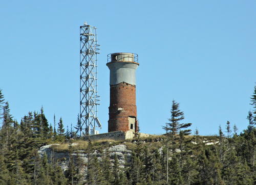
1862. Inactive since 1982. Approx. 12 m (39 ft) round cylindrical tower, formerly rising from the center of 1-1/2 story keeper's house. Lantern removed. The keeper's house was demolished in the 1980s, leaving only the tower standing; the upper part of the tower is still painted white, but the rest is unpainted. Critically endangered. Sibling of Pot à l'Eau-de-Vie. Jon Clay's photo is seen at right, Lighthouse Digest has a Coast Guard photo, Marinas.com has aerial photos, and Google has a satellite view. Long Pèlerin is a long, narrow island (the summit of a submerged ridge) in the St. Lawrence off Saint-André-de-Kamouraska. Located near the center of the island; visible distantly from the waterfront of Saint-André-de-Kamouraska. Accessible only by boat; tours of the island can be arranged through Société Duvetnor. Site open, tower closed. Owner/site manager: Canadian Coast Guard. ARLHS CAN-284.
Long Pèlerin (Long Pilgrim) (2)
1982. Active; focal plane 43.5 m (143 ft); white flash every 6 s. 14 m (45 ft) square cylindrical skeletal tower carrying daymark panels colored in a red and white checkerboard pattern. Located close to the historic lighthouse. Site open, tower closed. Owner/site manager: Canadian Coast Guard. CCG A-1832; Admiralty H2172; NGA 6664.

Old and new Long Pèlerin Lights, Kamouraska, 2016
photo copyright Jon Clay; used by permission

Information available on lost lighthouses:

Notable faux lighthouses:

Adjoining pages: North: Western Québec | Northeast: Northeastern Québec | East: Eastern Québec | Southwest: Southwestern Québec

Return to the Lighthouse Directory index | Ratings key

Posted September 12, 2003. Checked and revised February 16, 2024. Lighthouses: 31. Site copyright 2024 Russ Rowlett and the University of North Carolina at Chapel Hill.