Lighthouses of Canada: Western Québec

The nation of Canada was created by the British North America Act in 1867 with Ontario, Québec, New Brunswick, and Nova Scotia as the four original provinces. The province of Québec was the heart of New France, the former French empire in North America, from tthe founding of Québec city in 1608 until France was forced to cede its Canadian territories to Britain at the end of the Seven Years War in 1763.

Today Canada is a federation of ten provinces and three large federal territories in the far north of the country. Québec is the largest and second most populous of the provinces. It includes both sides of the St. Lawrence River and Estuary from Montréal to the Gulf of St. Lawrence as well as the north shore of the Gulf; it also extends far to the north with long coastlines on Hudson Bay and Hudson Strait. Its population, more than 8 million, is concentrated in the valley of the St. Lawrence.

The province once had at least 275 lighthouses but only about 80 remain today. A number of historic towers have been carefully restored but lighthouse preservation as a whole has been a little slower to take hold in Québec than in the maritime provinces. This seems to be changing for the better, with reports of several recent preservation and restoration efforts. However, there is no province-wide preservation association.

Québec is divided into 17 administrative regions (régions administratives). Outside of the major urban areas Québec is further divided into 86 county-level regional county municipalities (municipalités régionale de comté). This page covers lighthouses of upper Québec: the part of the province north of the St. Lawrence River surrounding the city of Montréal. The St. Lawrence is one of the world's greatest inland waterways: ocean-going ships sail the river to Montréal and many continue on the St. Lawrence Seaway to the Great Lakes.

Aids to navigation in Canada are maintained by the Canadian Coast Guard. In 2008 Parliament passed the Heritage Lighthouse Protection Act to designate and protect historic lighthouses.

French is the official language of Québec. The French word for a lighthouse, phare, is often reserved for the larger lighthouses; a smaller light or harbor light is called a feu (literally "fire," but here meaning "light"). The front light of a range (alignement) is the feu antérieur and the rear light is the feu postérieur. In French île is an island, cap is a cape, pointe is a promontory or point of land, roche is a rock, récife is a reef, baie is a bay, estuaire is an estuary or inlet, détroit is a strait, rivière is a river, and havre is a harbor.

ARLHS numbers are from the ARLHS World List of Lights. CCG numbers are from the Atlantic Coast portion of the List of Lights, Buoys, and Fog Signals of Fisheries and Oceans Canada for lighthouses below Montréal and from the Inland Waters list for lights in and west of Montréal. Admiralty numbers are from Volume H of the Admiralty List of Lights & Fog Signals. U.S. NGA numbers are from Publication 110.

General Sources
Quebec, Canada Lighthouses
Historical information, photos and travel directions, by Kraig Anderson.
Quebec, Canada Lighthouses
Fine aerial photos posted by Marinas.com.
Quebec
Photos of Quebec lighthouses posted by C.W. Bash.
Lighthouses in Quebec
Photos by various photographers available from Wikimedia.
World of Lighthouses - Atlantic Coast of Canada
Photos by various photographers available from Lightphotos.net.
Online List of Lights - Northern and Eastern Canada
Photos by various photographers posted by Alexander Trabas. Photos for this area are by Michael Boucher.
Leuchttürme Kanadas auf historischen Postkarten
Historic postcard views posted by Klaus Huelse.
List of Lights, Buoys, and Fog Signals
Official Canadian light lists.
GPSNauticalCharts
Navigational chart for this area.
Navionics Charts
Navigational chart for this area.

Lachine Range Front Light
Lachine Range Front Light, Lachine, October 2012
Wikimedia Creative Commons photo by Jean Gagnon

Lanaudière Region Lighthouses

D'Autray Regional County Municipality Lighthouses
Île Dupas Range Front
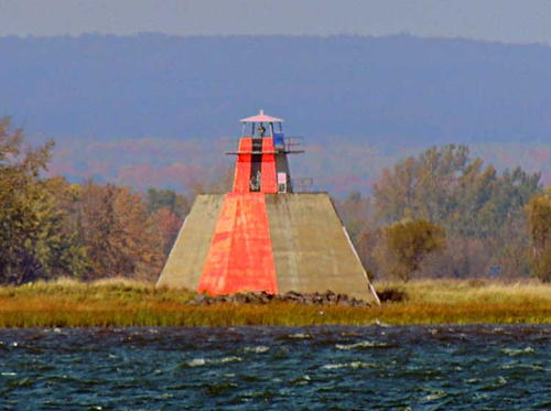
1907. Active; focal plane 14 m (46 ft); continuous green light visible only on the range line. 5 m (18 ft) square wood tower mounted on a square pyramidal concrete pier. Tower painted white, except the front is painted bright orange-red with a black vertical stripe on the range line. Trabas has Boucher's photo (also seen at right) and Google has a satellite view. This is a downstream range. Located on the Île aux Cochons on the northwest side of the river south of Berthierville; probably visible distantly from the southeast side south of Tracy. Site open, tower closed. Owner/site manager: Canadian Coast Guard. ARLHS CAN-1103; CCG A-2274; Admiralty H2450; NGA 5136.
* Île Dupas Range Rear (2)
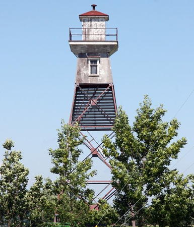
Date unknown (station established 1907). Active; focal plane 25.5 m (84 ft); continuous green light visible only on the range line. 20.5 m (67 ft) square skeletal mast carrying a trapezoidal slatted daymark painted bright orange-red with a black vertical stripe. Trabas has Boucher's photo and Google has a street view and a satellite view. The original lighthouse was a square skeletal tower with enclosed upper portion. Located at the end of the Rang de l'Île Dupas on the south end of the Île Dupas, 625 m (0.39 mi) north of the front light. Site open, tower closed. Owner/site manager: Canadian Coast Guard. ARLHS CAN-1104; CCG A-2275; Admiralty H2450.1; NGA 5140.
Course Île Saint-Ours Lower Range Rear
Date unknown. Active; focal plane 34 m (112 ft); continuous green light. 22 m (72 ft) square cylindrical skeletal tower carrying a trapezoidal slatted daymark painted orange with a black vertical stripe. Trabas has Boucher's photo and Google has an indistinct satellite view. This is a downstream range. The front light is on a much smaller tower. Located in a farm field about 800 m (1/2 mi) north of Lanoraie. Site and tower closed. CCG A-2278.6; Admiralty H2451.1; NGA 5148.

Île Dupas Range Front Light, Batiscan
photo copyright Michael Boucher; used by permission
Lavaltrie Range Front (3)
1915 (station established 1831). Active; focal plane 8 m (26 ft); continuous green light. 4 m (13 ft) square tower with lantern mounted on a concrete pier. Tower painted white, lantern roof red; the front of the tower is painted red with a black vertical stripe. Stephan Oligny has a closeup 2023 photo and Bing has a satellite view. This is an upstream range guiding vessels in a secondary channel on the north side of the river. Located on the east side of l’Île Hervieux, a low island off the waterfront of Lavaltrie. Accessible only boat or over the ice in winter. Site open, tower closed. Owner/site manager: Canadian Coast Guard. CCG A-2292; Admiralty H2460; NGA 5252.
Lavaltrie Range Rear (3)
1915 (station established 1831). Active; focal plane 20 m (66 ft); continuous green light. 18 m (56 ft) square pyramidal skeletal tower with lantern, gallery, and enclosed watch room. Tower painted black, watch room white, lantern white with a red roof. The front of the tower carries a large rectangular daymark, painted bright orange-red with a black vertical stripe on the range line. Trabas has Boucher's photo, Stephan Oligny has a closeup 2023 photo, and Google has a satellite view and a distant street view. This pyramidal lighthouse is a rare survivor; most lighthouses of this class have been replaced by skeletal masts. Located on an islet just off the south end of l’Île Hervieux. Accessible only boat or over the ice in winter. Site open, tower closed. Owner/site manager: Canadian Coast Guard. CCG A-2293; Admiralty H2460.1; NGA 5256.

L'Assomption Regional County Municipality Lighthouses
Mousseau Range Front
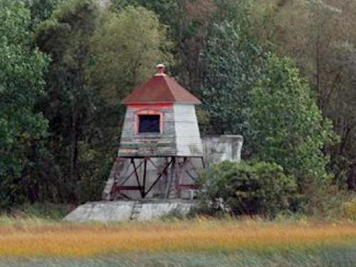
1914. Inactive since 1996. 6 m (20 ft) square wood lantern room with a pyramidal roof, supported by four iron legs on a square concrete pier. Jon Clay's photo is at right, Google has an indistinct satellite view. Clearly endangered. Located on the west side of the north end of Île Bouchard. Accessible only by boat. Site open, tower closed. Owner/site manager: unknown. ex-Admiralty H2462.
Mousseau Range Rear
1914. Inactive since 1996. 15 m (49 ft) square pyramidal skeletal tower with wood lantern and enclosed upper portion. Lighthouse originally painted white, but nearly all the paint has worn off. Clearly endangered. Google has an indistinct satellite view. Located about 700 m (0.42 mi) southwest of the front light. Accessible only by boat. Site open, tower closed. Owner/site manager: unknown. ex-Admiralty H2462.1.
 

Mousseau Range Front Light, Île Bouchard
photo copyright Jon Clay; used by permission
 
Île Ronde (Péninsule Bouchard) Range Front
1914. Inactive since 1995. 6 m (20 ft) square wood lantern house standing on a 4-legged steel platform. Lighthouse painted white (most of the paint has weathered away); lantern roof is red. Google has an indistinct satellite view. Endangered: the lighthouse is abandoned and deteriorating. Located an unknown distance southwest of the rear light. Accessible only by boat. Site open, tower closed. Owner/site manager: unknown. ex-CCG A-2300; ex-Admiralty H2463.
Île Ronde (Péninsule Bouchard) Range Rear
1914. Inactive since 1995. 17.5 m (57 ft) square pyramidal steel skeletal tower with lantern, gallery, and enclosed upper portion. Lighthouse painted white (most of the paint has weathered away); lantern roof is red. A photo by Lloyd Gross is at right and Google has an indistinct satellite view. Endangered: the lighthouse is abandoned and deteriorating. The range guided vessels headed upstream around the north side of the Îles de Verchères. Located on the west side of the Îles de Verchères opposite St.-Sulpice. Accessible only by boat. Site open, tower closed. Owner/site manager: unknown. ex-CCG A-2301; ex-Admiralty H2463.1.
Île Bouchard Range Rear (3)
Date unknown (station established 1902). Active; focal plane 22 m (73 ft); continuous green light visible only on the range line. 16.5 m (54 ft) square cylindrical skeletal tower. The tower also carries an inverted-trapezoidal slatted daymark painted orange with a black vertical stripe on the range line. No photo of the new light is available but Google has a satellite view. Anderson has a distant view of the earlier lighthouse. This is a downstream range. Located on the southeast side of the island, a long narrow island that divides the river near Verchères, roughly 20 km (13 mi) northeast of Montréal. Accessible only by boat. Site status unknown, tower closed. Owner/site manager: Canadian Coast Guard. ARLHS CAN-1262; CCG A-2327; Admiralty H2480.1; NGA 5392.
Île Bouchard Range Front (3?)
Date unknown (station established 1902). Active; focal plane 13 m (73 ft); continuous green light visible only on the range line. 9 m (30 ft) square cylindrical skeletal tower. The tower also a rectangular daymark painted orange with a black vertical stripe on the range line. Anderson has a photo of the earlier light, a square platform supported by four steel piles. Google has an indistinct satellite view. The light lists all describe this light as being on a "cylindrical mast," but Anderson's photos show otherwise. Located on the southeast side of the island 934 m (0.58 mi) southwest of the rear light. Accessible only by boat. Site status unknown, tower closed. Owner/site manager: Canadian Coast Guard. ARLHS CAN-1093; CCG A-2326; Admiralty H2480; NGA 5388.
Île Ronde Range Rear Light
Île Ronde Range Rear Light, St.-Sulpice, July 2007
Flickr photo copyright Lloyd Gross; used by permission

Montréal City Lighthouses

* [Tétreauville Range Front (2)]
Date unknown (station established 1911). Active; focal plane 14.5 m (48 ft); continuous green light visible only on the range line. 7.5 m (25 ft) steel post carrying a daymark colored orange with a black vertical stripe. Google has a street view and a satellite view. This is an upstream range. The original lighthouse was a square wood tower. Located on the Rue Bellerive at Rue Baldwin across the street from the Parc Promenade-Bellerive in Montréal. Site open, tower closed. ARLHS CAN-1203; CCG A-2359; Admiralty H2496; NGA 5544.
* [Tétreauville Range Rear (2)]
Date unknown (station established 1911). Active; focal plane 30 m (98 ft); continuous green light visible only on the range line. 22 m (72 ft) steel post carrying a daymark colored orange with a black vertical stripe. Google has a street view and a satellite view. Located on the Place Beauchesne in the Bellerive neighborhood of Montréal, 630 m (0.39 mi) south southwest of the front light. Site open, tower closed. CCG A-2360; Admiralty H2496.1; NGA 5548.
* Île Sainte-Hélène (Île Ronde Range Rear (2))
1912 (station established 1907). Inactive for many years (since the 1950s?). 14.5 m (48 ft) square concrete tower on a square pyramidal concrete base; square wooden lantern. Lighthouse painted white. Mario Hains has a November 2019 photo of the tower freshly repainted, Patrick Matte has an April closeup taken before the repainting, Huelse has a historic postcard view, and Google has a closeup 2022 street view and a good satellite view. Anderson records the history of this downstream range light; it replaced a 19.5 m (64 ft) square skeletal tower with lantern and gallery that served for only five years on a nearby pier. A 1929 photo and a 1927 aerial photo were taken during construction of the Jacques-Cartier Bridge; in the aerial photo the front light can be seen to the left of the bridge. The only lighthouse in the downtown area of Montréal, this light seemed endangered for many years; Wikimedia's 2005 photo is typical. In 2007 it was finally repainted, as seen in Bash's 2008 photo at right. It appears now to be in good structural condition. but still in need of a more complete restoration. Located below the Fort de l'Île Sainte-Hélène at the west side of the island in Montréal harbor. Accessible from the Jacques Cartier Bridge (QC 134); parking is nearby. Site open, tower closed. Owner/site manager: City of Montréal. ARLHS CAN-977.

Île Sainte-Hélène Light, Montréal, June 2008
Flickr Creative Commons photo by C.W. Bash
* Lachine Range Rear (2)
1900 (station established 1889). Active; focal plane 18 m (59 ft); continuous green light visible only on the range line. 17 m (55 ft) steel tower with lantern and a small gallery. Lighthouse painted white with red trim; the lantern dome is red. Jean Gagnon's photo is at right, Trabas has Boucher's closeup photo, Bash has a 2008 photo, Benoit Larocque also has a good photo, Wikimedia has several excellent photos, and Google has a street view and a satellite view. This is a downstream (eastbound) range guiding small craft to the Lachine marinas. The two towers are about 240 m (800 ft) apart. Located in Parc Saint-Louis, on Boulevard Saint-Joseph in Lachine. Site open, tower closed. Owner/site manager: Canadian Coast Guard. ARLHS CAN-267; CCG I-1195; Admiralty H2519;.1 NGA 5647.
* Lachine Range Front (2)
1900 (station established 1889). Active; focal plane 9 m (30 ft); continuous green light visible only on the range line. 7 m (24 ft) steel tower with lantern and a small gallery. Lighthouse painted white with red trim; the lantern dome is red. Jean Gagnon's photo is at the top of this page, Bash has a 2008 photo, Trabas has Boucher's closeup, Wikimedia has several excellent photos, Marinas.com has aerial photos, Huelse has a historic postcard view, and Google has a street view and a satellite view. In 2021 residents proposed improvements to the surroundings of the lighthouse, with better public access. Located at the end of the wharf adjoining Parc Saint-Louis, on Boulevard Saint-Joseph in Lachine. Accessible by walking the pier. Site open, tower closed. Owner/site manager: Canadian Coast Guard. . ARLHS CAN-268; CCG I-1194; Admiralty H2519; NGA 5646.
#Dixie Range Rear
1915. Inactive since 2018 and demolished in 2019. This was a 26 m (85 ft) square pyramidal steel skeletal tower with lantern and gallery, mounted on a square concrete pier. Lighthouse painted white; lantern roof painted red. There was also a large rectangular red slatted daymark with a vertical black stripe on the range line. Bash has a 2008 photo and Trabas has Boucher's photo. Google's satellite view shows the empty pier of the former lighthouse. This was a downstream (eastbound) range guiding vessels in a reach across Lac Saint-Louis. In 2018 CCG replaced the front light (next entry) with a sector light and announced its intention to remove the rear lighthouse. The removal took place in July 2019. Anderson has a photo of a small warning light on the otherwise empty pier. Located in the river off Dorval, about 3.2 km (2 mi) west of Lachine. Accessible only by boat, but there are good views from the Parc du Millénaire and other points on the north shore in the Dorval area. Accessible only by boat. Site open, tower closed. ARLHS CAN-1407; ex-CCG I-1202; ex-Admiralty H2518.41; NGA 5703.
Lachine Range Rear Light
Lachine Range Rear Light, Lachine, October 2012
Wikimedia Creative Commons photo by Jean Gagnon
#Dixie Range Front
Date unknown (station established 1915). This was an 8.5 m (28 ft) round tower mounted on an octagonal concrete base on a square concrete pier. Trabas has Boucher's photo. In 2018 the range light was replaced by the Dixie Sector light (focal plane 7.5 m (25 ft); red, white or green light depending on direction, 3 s on, 3 s off) on a short skeletal tower surrounded by a cylindrical daymark, colored white with red bands at the top and bottom, mounted on the base of the original lighthouse. Google has a satellite view of the new light. Located in the St. Lawrence 1069 m (1 mi) southwest of the rear light. Accessible only by boat. Site open, tower closed. ex-CCG I-1201; Admiralty H2518.4; NGA 5702. Active light: CCG I-1201.5.
Dorval Course Range Rear
Date unknown. Active; focal plane 24 m (79 ft); continuous green light visible only on the range line. 24 m (79 ft) round steel tower carrying a daymark colored orange with a black vertical stripe and mounted on a round concrete pier with gallery. Trabas has Boucher's photo and Google has a satellite view. This is a downstream range guiding vessels on the St. Lawrence Seaway on their approach to Montréal. Located in the St. Lawrence about 800 m (1/2 mi) northwest of the Dixie Range Front Light. Accessible only by boat. Site open, tower closed. CCG I-014.3; Admiralty H2517.11; NGA 5708.
Dorval Course Range Front
Date unknown. Active; focal plane 11 m (36 ft); continuous green light visible only on the range line. 11 m (36 ft) round concrete tower on a conical pier. Trabas has Boucher's photo and Google has a satellite view. Located 1069 m (0.6 mi) southwest of the rear light. Accessible only by boat. Site open, tower closed. CCG I-014.2; Admiralty H2517.1; NGA 5704.

Montérégie Region Lighthouses

Most of the Montérégie Region is on the south side of the Saint Lawrence opposite Montréal. The region includes one regional county municipality on the north side, located in a wedge-shaped area between the Saint Lawrence and Ottawa Rivers. For Montérégie lighthouses on the south side of the river see the Southwestern Québec page.

Vaudreuil-Soulanges Regional County Municipality Lighthouses
The Soulanges Canal was opened in 1899 to provide a route around the rapids of the St. Lawrence between Lac St.-Louis and Lac St.-François. The canal is 23 km (14 mi) long and has five locks. It was closed in 1958 following inauguration of the St. Lawrence Seaway. Ships on the Seaway today use the rebuilt Beauharnois Canal on the south side of the river.
* Soulanges Canal Lower Entrance Range Front
1902. Inactive since 1960. 9 m (29 ft) cast iron tower with lantern, painted white; lantern roof painted gray. Kate McDonnell has a good closeup photo and Google has a satellite view. The lighthouse was discontinued when the canal was closed following inauguration of the St. Lawrence Seaway. Endangered: a 2023 photo shows the lighthouse in poor condition. Located in Pointe-des-Cascades at the end of the north pier at the eastern canal entrance; this is also at the confluence of the Ottawa and St. Lawrence Rivers. Accessible by walking the pier. Site open, tower closed. Owner/site manager: Village de Pointe-des-Cascades. ARLHS CAN-1198.
* Soulanges Canal Lower Entrance Range Rear (relocated)
1902. Inactive since 1960. 14 m (45 ft) cast iron tower with lantern and gallery, painted white; lantern roof painted black. Pierre Bona's photo is at right, Ralf Winter has a 2022 photo, Davy Ray has a street view, and Google has a satellite view. The lighthouse was discontinued when the canal was closed following inauguration of the St. Lawrence Seaway. The tower was restored and relocated to a municipal park. In the fall of 2020 it was removed for restoration, returning in November. Located on the south side of the canal in the Parc des Ancres in the center of Pointe-des-Cascades. Site open, tower closed. Owner/site manager: Village de Pointe-des-Cascades. ARLHS CAN-1199.
* Soulanges Canal Upper Entrance Range Rear
1902. Inactive since 1960. Approx. 11 m (30 ft) cast iron tower with lantern and gallery, painted white; lantern roof painted black. Google has a street view and a satellite view. The lighthouse was discontinued when the canal was closed following inauguration of the St. Lawrence Seaway. The tower has recently been restored; it is an attraction in a riverside public campground. Located near the campground entrance on the east side of the canal in Les Coteaux, about 480 m (1585 ft) north of the front light. Site open, tower closed. Owner/site manager: Ville de Coteau-du-Lac. ARLHS CAN-1201.
* Soulanges Canal Upper Entrance Range Front
1902. Inactive since 1960. 11 m (35 ft) cast iron tower with lantern, formerly painted in a gaudy red, white, and blue pattern. but now painted white. Dennis Jarvis's photo is at the bottom of this page, Yves Esclamadon has a 2021 photo, Geneviève Juillet has a 2022 closeup, and Google has a satellite view. The lighthouse was discontinued when the canal was closed following inauguration of the St. Lawrence Seaway. The tower had been restored and was an attraction in a riverside public campground. When Greg Fitzgerald visited in May 2022 he found the lighthouse had been removed for restoration. It was returned later in the year, painted white, as seen in André Chalifour's October 2022 street view. Located on the west side of the entrance to the canal in Les Coteaux. Site open, tower closed. Owner/site manager: Ville de Coteau-du-Lac. ARLHS CAN-1200.
Soulanges Lower Entrance Range Rear Light
Soulanges Canal Lower Entrance Rear Light, April 2006
Wikimedia Creative Commons photo by Pierre Bona
Pointe-au-Foin Upstream Range Rear
Date unknown. Active; focal plane 18 m (59 ft); continuous green light. 16 m (52 ft) square pyramidal skeletal tower carrying a triangular slatted daymark painted orange with a black vertical stripe. Trabas has Boucher's photo and Google has a street view and a satellite view. This range guides westbound vessels in the Seaway channel. The front light is on a 10 m (33 ft) skeletal mast. Located at the end of 8e Rue (Eighth Street) in Saint-Zotique. Site and tower closed (private property), but the light can be seen from the street. CCG I-0094.1; Admiralty H2543.1; NGA 6068.
Pointe-au-Foin Downstream Range Rear
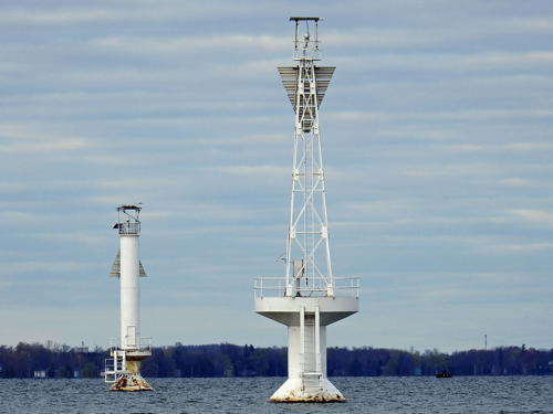
Date unknown. Active; focal plane 20 m (66 ft); continuous red light. 20 m (66 ft) square pyramidal skeletal tower mounted on a round concrete pier and carrying a triangular daymark painted orange with a black vertical stripe. Trabas has Boucher's photo (also seen at right), Jean-Sébastien Paré has a a distant street view from the Saint-Zotique beach, and Google has a satellite view. This range guides eastbound vessels in the Seaway channel. Located about 400 m (1/4 mi) offshore from Saint-Zotique. Accessible only by boat but easy to see from shore. CCG I-0094.3; Admiralty H2543.51; NGA 6071.
Pointe-au-Foin Downstream Range Front
Date unknown. Active; focal plane 20 m (66 ft); red light, 2 s on, 2 s off. 14 m (46 ft) round white cylindrical tower mounted on a round concrete pier and carrying a triangular daymark painted orange with a black vertical stripe. Trabas has Boucher's closeup photo, Jean-Sébastien Paré has a a distant street view from the Saint-Zotique beach, and Google has a satellite view. Located 300 m (0.2 mi) southwest of the front light. Accessible only by boat but easy to see from shore. CCG I-0094.2; Admiralty H2543.5; NGA 6069.
Pointe Beaudette Range Front
Date unknown (1962?). Active; focal plane 11 m (36 ft); continuous green light. 11 m (36 ft) round cylindrical tower, painted white, carrying a triangular slatted daymark, painted orange with a black vertical stripe, and mounted on a round pier. Trabas has Boucher's photo and Google has a satellite view. Located in the river about 750 m (0.46 mi) northeast of Pointe Beaudette. Accessible only by boat. Site open, tower closed. CCG I-0099; Admiralty H2544; NGA 6088.

Pointe-au-Foin Downstream Range Front (left) and Rear Lights, Lac Saint-François, 2018
photo copyright Michael Boucher; used by permission
#Pointe Beaudette (Pointe au Beaudet, McKie Point) (2) (?)
1877 (station established 1847). Inactive since 1962 and apparently demolished sometime in 2012-13. This was a 9 m (30 ft) square pyramidal wood tower, painted white; no lantern. The lighthouse was replaced by a pair of range lights (see next entry). It was to be demolished after deactivation, but instead it was leased by two neighboring landowners. The lantern was removed after it was badly damaged by a storm in 1995. In 2012 the Coast Guard offered to sell the lighthouse to the municipality of Rivière-Beaudette, but the town council declined because there was no possibility of public access to the property. Since at least October 2014 Google's satellite view has shown that the tower has disappeared from the site, perhaps relocated but more likely demolished. Formerly located on a sharp point on the north side of the river near Rivière Beaudette and the Ontario border. Site closed (private property). Owner/site manager: private. ARLHS CAN-1124.
Pointe Beaudette Range Rear
Date unknown (1962?). Active; focal plane 18 m (59 ft); continuous green light. 17.5 m (57 ft) square pyramidal skeletal tower, painted white. The tower carries a triangular slatted daymark, painted orange with a black vertical stripe. Trabas has Boucher's closeup photo and Google has a closeup street view and an indistinct satellite view. Located near the end of the Chemin Penville, close to the location of the historic lighthouse. Site status unknown. CCG I-0099.1; Admiralty H2544.1; NGA 6092.

Ottawa River: Laurentides Region Lighthouses

Additional lighthouses of the Ottawa River are described on the Southeastern Ontario page.

Deux-Montagnes Regional County Municipality Lighthouses
* Marina d'Oka
Date unknown. Active (privately maintained and unofficial; charted by Navionics); focal plane about 6 m (20 ft); red flash every 4 s. 5 m (17 ft) octagonal wood tower painted white with red trim. Sylvie Lavalle has the 2021 closeup photo seen at right, another photo is available, the lighthouse also appears on the marina's web site, and Google has a street view and a satellite view. Located on the east breakwater of the marina at Oka. Site open, tower closed. Owner/site manager: Marina d'Oka.
Pointe aux Anglais (4)
1987(?) (station established 1873). Active (privately maintained since 1998); focal plane 11 m (36 ft); red light, 1 s on, 1 s off. 6.5 m (22 ft) square cylindrical tower with lantern and gallery, painted white with two narrow red horizontal bands, mounted on a concrete pier. Marinas.com has distant aerial photos and Google has a satellite view. The pier was rebuilt in 1892, so it supported some of the earlier towers. The light was the front light of a range until sometime in the 1980s. Located on a reef in the Lac des Deux Montagnes at Pointe-aux-Anglais, about 10 km (6 mi) west of Oka. Accessible only by boat, but visible from shore. Owner/site manager: Club de Voile des Laurentides. ARLHS CAN-1271; CCG I-1245.

Ottawa River: Outaouais Region Lighthouses

Pontiac Municipality Regional County Lighthouses
Lower Allumette Lake (Spence Island) (2)
1910 (station established 1885). Inactive since the 1920s. 8 m (26 ft) square pyramidal wood tower with lantern. Trees hide the lighthouse in Bing's satellite view of the location. It has only been discovered recently that this lighthouse is still standing. Gravely endangered: abandoned for eight decades, the building is embedded in vegetation and is descending into ruin. Located on an island at the lower end of Lower Allumette Lake, about 8 km (5 mi) north of Waltham. Accessible only by boat. Site open, though somewhat difficult to find. ARLHS CAN-1122.
Passage Lower (Pointe Leblanc, Lower Narrows) (3)
2021 replica of 1907 lighthouse (station established 1887). Active; focal plane 7.5 m (25 ft); red flash every 4 s. 8 m (27 ft) square pyramidal tower, colored white with red trim. Bing has a good satellite view. The foundation of the lighthouse was damaged by severe flooding in the spring of 2019, and the Coast Guard removed the lighthouse in March 2020. The intention was to replace the lighthouse with a replica. Covid restrictions prevented the replacement during 2020 but since the light is back in the CCG List of Lights the replacement must have occurred by 2021. The original light here was on a pole. Located on the north side of the river on the west end of the Île Leblanc, off the Île des Allumettes about 5 km (3 mi) west of Pembroke, Ontario. Accessible only by boat. Site open, tower closed. Owner/site manager: Canadian Coast Guard. ARLHS CAN-891; CCG I-1308.

Marina d'Oka Light, Oka, August 2021
Google Maps photo by Sylvie Lavalle

Information available on lost lighthouses:

  • Chute à Blondeau Range Lights (1912-ca. 1960), Ottawa River. ARLHS CAN-1183.
  • Côteau Landing (2) (1877-?), St. Lawrence River west of Montréal. Nothing remains of this lighthouse. ARLHS CAN-966.
  • Dorval (1874-1930s?), St. Lawrence River. The lighthouse has been demolished. ARLHS CAN-969.
  • Fort William (1913-?), Lac aux Allumettes, Ottawa River. Huelse has a historic postcard view. The lighthouse was demolished. There is a mast light today on the Fort William pier. ARLHS CAN-970; CCG I-1309.
  • Île aux Allumettes (1906-?), Ottawa River. Nothing remains of this lighthouse. ARLHS CAN-1090.
  • Île Ronde Range Front (1908-?), Montréal. This range was discontinued; the rear light survives (see above).
  • Île Rosalie (1912-1978), Ottawa River. The historic lighthouse was destroyed by vandals in 1978 and replaced by a metal tower. However, the location is marked only by a lightbuoy today. ARLHS CAN-1106; CCG I-1283.1.
  • Longue Pointe Traverse Downstream Range Lights (1903-1980s?), Montréal. The original range lights were on the west side of the river near Longue Pointe. The modern lights have been moved as an upstream range to the other side of the river in Longueuil (see the Southern Québec page). ARLHS CAN-1120 and 1121.
  • Montréal Harbour Range Lights (1830-1890s?), Montréal Harbor. Very little is known about these lighthouses. ARLHS CAN-1185 and 1186.
  • Oka (Pointe aux Anglais Range Rear) (1898-late 1990s), Ottawa River. See Anderson's Pointe aux Anglais page. The original lighthouse was on a pier in the river. The second (1907) lighthouse was on a hilltop to serve as the rear range light. The 1907 lighthouse was replaced by a skeletal tower in 1958. ARLHS CAN-1126.
  • Oka Wharf (1903-1997), Ottawa River. CCG has no listing for this light today, but there is a simple post light on the quay. ARLHS CAN-1127.
  • Pointe à Cadieux (1875-1996), Ottawa River. Nothing remains of this lighthouse; it was replaced by a buoy (CCG I-1242.55). ARLHS CAN-980.
  • Pointe au Chêne (1913-1940s), Ottawa River. Nothing remains of this lighthouse. ARLHS CAN-1278.
  • Pointe Caron (1878-1934), Baie d'Urfé, west of Montréal. The lighthouse is gone and there is no longer a light at this location.
  • Pointe Claire (1860-?), west of Montréal. Nothing remains of this lighthouse. ARLHS CAN-982.
  • Pointe McTavish (1871-1940s), Ottawa River. Nothing remains of this lighthouse.
  • Repentigny Range Lights (1843-?), St. Lawrence River below Montréal. This range was discontinued and the lighthouses demolished. ARLHS CAN-1159 and 1160.
  • Sainte-Anne-de-Bellevue Canal Southeast Entrance (?-?), Ottawa River entrance. The canal remains in service but the lighthouse has disappeared.
  • Sainte-Anne-de-Bellevue Traverse Range Lights(1874-?), Ottawa River. Nothing remains of these lighthouses. Google has street views of the modern front and rear range lights (CCG I-1227-28) that guide vessels to the northwest entrance of the Sainte-Anne-de-Bellevue Canal.
  • Sainte-Placide Course Range Rear (1902-?), Ottawa River. Nothing remains of this lighthouse.
  • Sainte-Placide Traverse Range Front and Rear (1874-?), Ottawa River. Nothing remains of these lighthouses.
  • Saint-Sulpice Course and Traverse Range Lights (1914-?), St. Lawrence River below Montréal. These ranges were discontinued and the lighthouses demolished.
  • Supple Point (1910-?), Ottawa River. Nothing remains of this lighthouse. ARLHS CAN-1202.
  • Way Shoal (1870-1906), Ottawa River near Thurso. Nothing remains of this lighthouse. ARLHS CAN-1305.


Soulanges Canal Upper Entrance Range Front Light, June 2008
Flickr Creative Commons photo by Dennis Jarvis

Notable faux lighthouses:

Adjoining pages: Northeast: Central Québec | Southeast: Southern Québec | Southwest: Southwestern Québec | West: Southeastern Ontario

Return to the Lighthouse Directory index | Ratings key

Posted September 12, 2003. Checked and revised July 31, 2023. Lighthouses: 32. Site copyright 2023 Russ Rowlett and the University of North Carolina at Chapel Hill.