Lighthouses of Russia: Eastern White Sea

Russia (Россия, Rossiya in Russian) is by far the world's largest country, spanning a little over 150° in longitude. It is organized as the Russian Federation (Rossiyskaya Federatsiya) with members known as federal subjects (sub'yekty federatsii). Russia is primarily a continental nation but it has important coastlines on the Baltic, Black, and Caspian Seas and very long coastlines on the Arctic Ocean and North Pacific Ocean. To guard these coasts it operates hundreds of lighthouses, many of them historic.

The northwestern corner of Russia lies on the Barents Sea, an arm of the Arctic Ocean. The broad, eastward-pointing Kola Peninsula (Kolskiy Poluostrov) separates the Barents Sea from the nearly-enclosed White Sea, which extends southward more than 500 km (300 mi). Arkhangel'sk, located at the southeasternmost point of the White Sea, became Russia's chief port under Ivan the Terrible in the mid 1500s and there has been a lively trade between Western Europe and Arkhangel'sk through these northern waters for almost 500 years.

This page lists includes lighthouses on the east side of the White Sea in the northern part of the vast Arkhangel'sk Oblast, one of the members of the Russian Federation.

The Russian word for a lighthouse is mayak (маяк); ostrov is an island, mys is a cape, bukhta or guba is a bay, zaliv is a larger bay or gulf, proliv is a strait, reka is a river, and gavan' is a harbor.

Russian lighthouses are owned by the Russian Navy and maintained by the Navy's Office of Navigation and Oceanography (Управление навигации и океанографии).

ARLHS numbers are from the ARLHS World List of Lights. Russian light list (RU) numbers are from Russian Navy Publication 2105, as reported by the Admiralty. Admiralty numbers are from volume L of the Admiralty List of Lights & Fog Signals. U.S. NGA numbers are from Publication 115. The Russian light list, Огни и знаки (Lights and Signs), is not available online.

General Sources
Online List of Lights - Russia - Arctic Sea Coast
Photos by various photographers posted by Alexander Trabas.
World of Lighthouses - Arctic Coast of Russia
Photos available from Lightphotos.net.
White Sea Lighthouses in Russia
Photos available from Wikimedia.
Russische Leuchttürme auf historischen Postkarten
Historic postcard images posted by Klaus Huelse.

Mud'yugskiy Light, Arkhangel'sk, July 2021
Google Maps photo by Pavel Zuikov
Mud'yugskiy Area (Arkhangel'sk Approach) Lighthouses
Russia's ancient northern seaport of Arkhangel'sk is built at the head of the delta of the Dvina River. The numerous lighthouses of the delta are described on the Arkhangel'sk page.
Ostrov Lebedinskiy (Lebedin) (2?)
Date unknown. Active; focal plane 11 m (36 ft); white flash every 5 s. 10 m (33 ft) square skeletal tower covered with siding painted white with a black vertical stripe on each face. Alexey Vaigachev has a street view, Victor Mitrofanov has a view from the sea, and Google has a satellite view. NGA lists a hexagonal wooden tower. Located on a marshy point marking the entrance to the Korabel'nyy Branch of the Northern Dvina River, which leads to Arkhangel'sk. Accessible only by boat. Site status unknown. RU-3720; Admiralty L6978; NGA 16088.
Mud'yugskiy Bashen Range Rear (1)
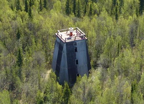
1875. Inactive. Approx. 21 m (69 ft) square pyramidal wood tower with lantern. The lighthouse is unpainted; lantern painted red. Alexey Skrobanskiy has the photo seen at right, Anatoliy Popov has a 2007 photo, qsl.net has a photo, Alexey Vaigachev has a wintry street view, Wikimedia has a historic postcard view, and Bing has a satellite view. Clearly endangered. Located near the southern tip of Mud'yugskiy Island, about 8 km (5 mi) southeast of the Mud'yugskiy lighthouse. Site status unknown. ARLHS ERU-002.
Mud'yugskiy Bashen Range Rear (2)
Date unknown (station established 1875). Active; focal plane 30 m (98 ft); continuous red or white light, depending on direction. Approx. 28 m (92 ft) square skeletal tower. The lighthouse carries a slatted daymark painted white with a red vertical stripe. Alexey Skrobanskiy has the photo seen at right, Anatoliy Popov has a 2007 photo, and Bing has a satellite view. Located adjacent to the historic lighthouse. Site status unknown. RU-3621; Admiralty L6972.1; NGA 16058.
Mud'yugskiy Bashen Range Front
Date unknown (station established 1875). Active; focal plane 12 m (39 ft); continuous red light. 8 m (26 ft) square pyramidal wood skeletal tower carrying a slatted daymark painted red with a white vertical stripe on each face. Alexandr Lobanov has a winter 2021 street view and Google has a satellite view. Located about 1.65 km (1 mi) north northwest of the rear light. Site status unknown. Admiralty L6972; NGA 16056.
Mud'yugskiy Turning Range Rear
Date unknown. Active; focal plane 13 m (43 ft); green flash every 3 s. 12 m (39 ft) square pyramidal skeletal tower carrying a slatted daymark painted white with a red vertical stripe. The front light is on a similar tower 8 m (26 ft) tall. A photo of both lights is available and Bing has an indistinct satellite view. Located about 3 km (2 mi) south of the Mud'yugskiy lighthouse (next entry). Site status unknown. RU-3686; Admiralty L6973.1; NGA 16052.


Mud'yugskiy Bashen Rear Lights, Arkhangel'sk, July 2018
Google Maps photo by Alexey Skrobanskiy

Mud'yugskiy
1838. Active; focal plane 40 m (131 ft); two white flashes every 9.7 s. 40 m (131 ft) round stone tower with lantern and gallery. Fresnel lens in use. Fog horn (8 blasts every 40 s). 1-story wood keeper's house. After being restored, this historic lighthouse was painted bright yellow with white trim and a small red lantern, as seen in a 2009 photo and in a second photo. However Pavel Zuikov's 2021 photo at the top of this page show the lighthouse repainted all white. Alexey Vaigachev has a 2016 street view and Google has a good satellite view. Wikimedia has a historic photo. This is the oldest lighthouse of the Russian North and the traditional landfall light for Arkhangel'sk. The yellow daymark is historically accurate: a 1904 light list describes the tower as yellow. Located on an island just off the main (eastern) entrance to the Dvina delta. Site status unknown. ARLHS ERU-146; RU-3610; Admiralty L6970; NGA 16044.

Northern Primorsky District Lighthouses
Mys Kuyskiy
Date unknown. Inactive since at least 2021. 22 m (72 ft) skeletal tower carrying a red slatted daymark. No photo available Google has an indistinct satellite view. Located high atop a cape about 25 km (15 mi) north of Mud'yugskiy Island. Site status unknown. ARLHS ERU-250; RU-3595; ex-Admiralty L7020; NGA 16132.
Mys Kerets
Date unknown. Active; focal plane 20 m (66 ft); two white flashes every 7.5 s. Approx. 16 m (52 ft) square skeletal tower. The front of the tower is covered by a slatted daymark painted white with a red vertical stripe. A closeup photo is available and Google has a distant satellite view. Located on a cape about 30 km (19 mi) north northwest of Mys Kuyskiy. Site status unknown. ARLHS ERU-244; RU-3585; Admiralty L7024; NGA 16136.
Zimnegorskiy
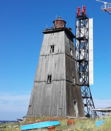
1878. Active; focal plane 126 m (414 ft); two white flashes every 16 s. 19 m (62 ft) square pyramidal wood tower; lantern removed. Lighthouse painted with black and white vertical stripes. A photo is at right, a historic photo showing the former lantern is available, and Bing has a satellite view. This lighthouse is a rare holdover from the tsarist era. The light station also includes a historic weather station and coast rescue station. The station stands high on a promontory at the northern entrance to Dvina Bay; Wikimedia has a historic view from the sea. . Located about 120 km (75 mi) northwest of Arkhangel'sk. Probably accessible only by boat. Site status unknown. ARLHS ERU-075; RU-3580; Admiralty L7026; NGA 16140.
[Mys Veprevskiy (2?)]
Date unknown. Active; focal plane 36 m (118 ft); two white flashes every 15 s. 11 m (36 ft) round post with a small gallery and lantern. Post painted yellow, lantern red. Lightphotos.net has a photo and Google has a satellite view. The original lighthouse has been demolished. Located on a headland at Veprevskiy, about 25 km (15 mi) northeast of Zimnegorskiy. Site open, tower closed. ARLHS ERU-285; RU-3560; Admiralty L7030; NGA 16144.
Zimnyaya Zolotitsa
Date unknown. Active; focal plane 39 m (128 ft); white flash every 6 s. 10 m (33 ft) square pyramidal wood skeletal tower carrying a slatted daymark painted white with a black vertical stripe. No photo available but Bing has a satellite view. Located on a bluff south of the mouth of the Zolotitsa River. Site status unknown. ARLHS ERU-290; Admiralty L7032; NGA 16148.

Zimnegorskiy Light, summer 2013
unattributed Polar Post photo

Mezensky District Lighthouses
Intsy
1898. Active; focal plane 35 m (115 ft); continuous white light. 20 m (66 ft) square cylindrical tower with lantern and gallery, rising from the front of a 1-story keeper's house. A photo by I. Anufriev is at right, Lightphotos.net has Yuri Matseevskii's photo, and Google has a good satellite view. In the photos the building appears to have a red brick veneer and the tower appears to have been raised in height with a concrete extension. A Russian page says that the lighthouse is a copy of the Mys Chesmenskiy Light (see Southern White Sea), but that lighthouse has an octagonal tower. Located on a promonory just north of Intsy, about 80 km (50 mi) northeast of the Zimnegorskiy lighthouse. Site status unknown. ARLHS ERU-036; RU-3540; Admiralty L7038; NGA 16152.
Ruch'i (2?)
Date unknown. Active; focal plane 47 m (154 ft); white flash every 4 s. 15 m (49 ft) square cylindrical skeletal tower; three sides of the tower are covered by a daymark that is supposed to be painted red with a white vertical stripe, although the red is not seen in Sergey Zubov's photo. Google has a satellite view. NGA formerly described this as a "skeletal tower atop a church tower." Located at the south side of the river entrance in Ruch'i, about 28 km (18 mi) east of Intsy. Site status unknown. ARLHS ERU-271; RU-3530; Admiralty L7042; NGA 16156.
Megra
Date unknown. Active; focal plane 32 m (105 ft); white flash every 3 s. 13 m (43 ft) skeletal tower, painted white with a black vertical stripe. No photo available but Bing has a fuzzy satellite view. Located on bluffs north of the entrance to the village of Megra. Site status unknown. ARLHS ERU-256 RU3520; Admiralty L7048; NGA 16160.
Intsy Light
Intsy Light, Intsy, May 2011
ex-Panoramio photo copyright I. Anufriev; permission requested
Yuzhnyy Mayda (Oleniy Nos)
Date unknown. Active; focal plane 34 m (112 ft); white flash every 5 s. 13 m (43 ft) skeletal tower, painted white or carrying a white slatted daymark. No photo available, and the tower is barely visible in Google's satellite view. Located on bluffs about 10 km (6 mi) southwest of the village of Mayda. Site status unknown. RU3515; Admiralty L7052; NGA 16164.
Mys Voronovski (Mys Voronov)
Date unknown. Active; focal plane 37 m (121 ft); white light, 4.5 s on, 10.5 s off. 6 m (20 ft) short skeletal tower mounted at the peak of the roof of a 1-story wood keeper's cottage; NGA currently describes it as a 6 m (20 ft) square pyramidal tower. The location of the light is not clear in Bing's fuzzy satellite view of the station. Located on a promontory at the east entrance to the narrow section of the White Sea, across from the Kola Peninsula. Site status unknown. ARLHS ERU-287; RU-3490; Admiralty L7068; NGA 16168.
#Morzhovskiy (Ostrov Morzhovets) (3)
1927 (station established 1842). Inactive and apparently demolished. Approx. 15 m (49 ft) square pyramidal wood tower with lantern, similar to the older Mud'yugskiy lighthouse (see above). The lighthouse was unpainted; lantern painted red. Lightphotos.net has a photo taken in 2005 but Polar Post has an aerial photo that does not show the old lighthouse. A photo by Alexandr Oboimov may show ruins of the old lighthouse.
Morzhovskiy (Ostrov Morzhovets) (4)
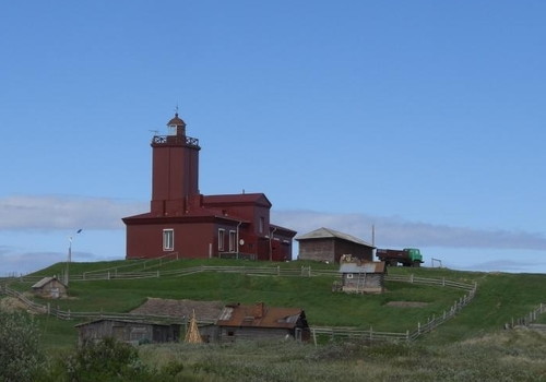
1974 (station established 1842). Active; focal plane 47 m (154 ft); two white flashes every 8.6 s. 30 m (98 ft) round concrete tower with lantern and gallery, painted with black and white horizontal bands. A photo is at right and Lightphotos.net has a closeup and another photo, but Google has only a very distant satellite view of the island. Huelse has a historic postcard view of the second lighthouse, an octagonal brick lighthouse built in 1892. This is a staffed station. Located on the southwest side of Morzhovets Island, about 17 km (11 mi) north of Koyda. Site status unknown. ARLHS ERU-051; RU-3350; Admiralty L7062; NGA 16176.
Morzhovskiy Northwest (Ostrov Morzhovets (1)
1842. Inactive. Approx. 8 m (26 ft) square wood tower rising from one end of a 1-story wood keeper's house. Google has a satellite view. According to Lightphotos.net the house is marked on Russian charts as "old lighthouse." A light at this location is listed without description in Findlay's 1879 light list. Critically endangered. Located on the northwestern point of Morzhovets Island. Site status unknown.
Yurovatyy
Date unknown. Probably inactive but listed with focal plane 19 m (62 ft); two white flashes every 6 s. 5 m (16 ft) square pyramidal wood tower with a red lantern. No photo available but Google has a distant satellite view of the station. Located about 50 km (30 mi) west northwest of Mys Abramovskiy. Site status unknown. Admiralty L7070; NGA 16172.
#Abramovskiy
Date unknown (station established 1912). Collapsed in 2019. Formerly a 14 m (46 ft) square cylindrical wood tower with lantern and gallery, attached to a 1-story utility building. The lighthouse was critically endangered for years: Yuri Matseevskii's photo shows the lighthouse with a severe lean and guy wires that were not providing any support. Lightphotos.net has a Polar Post photo showing the wreckage of the lighthouse. Google has only a very distant satellite view of the area. Located on a promontory about 19 km (12 mi) east of Koyda. Site status unknown. ARLHS ERU-232; RU-3295; Admiralty L7074; NGA 16188.
Ostrov Morzhovets Light
Ostrov Morzhovets Lighthouse, White Sea Throat
unattributed Polar Post photo
Nerpinskiy
Date unknown. Active; focal plane 44 m (144 ft); two white flashes every 6 s. 17 m (56 ft) square skeletal tower. The upper portion of the tower appears to be enclosed by a slatted daymark painted white with a red vertical stripe on each face. No photo available but Google has a satellite view. Located on Mys Nerpinskiy, the cape on the west side of the entrance to the Mezenskaya Gulf. Site status unknown. ARLHS ERU-260; RU-3280; Admiralty L7078; NGA 16196.
Maslyanyy
Date unknown. Probably inactive but listed with focal plane 19 m (62 ft); white flash every 3 s. 19 m (62 ft) square skeletal tower supposedly carrying a daymark painted with black and white bands. Google has a satellite view. The lighthouse appears to be abandoned. Located on Mys Maslyanyy, the cape on the west side of the entrance to the Mezen River estuary. Site status unknown. ARLHS ERU-255; RU-3260; Admiralty L7084; NGA 16200.
Reka Mezen (Mezen River) Range Rear
Date unknown. Active; focal plane 32 m (105 ft); white light, 1.5 s on, 1.5 s off. 12 m (39 ft) square cylindrical skeletal tower carrying diamond shaped and trapezoidal daymarks painted white with a black vertical stripe. No photo available but Google has a fuzzy satellite view. This is the entrance range for the Mezen River, a major river of northern Arkhangel'sk Oblast. The front light is on a similar 8 m (26 ft) tower. Located on the west side of the Mezen estuary. Site status unknown. ARLHS ERU-257; Admiralty L7090.1; NGA 16212.

Information available on lost lighthouses:

Adjoining pages: East: Western Nenetsia | South: Arkhangel'sk Area | Northwest: Northern Kola Peninsula

Return to the Lighthouse Directory index | Ratings key

Posted December 7, 2005. Checked and revised April 4, 2024. Lighthouses: 23. Site copyright 2024 Russ Rowlett and the University of North Carolina at Chapel Hill.