Lighthouses of Russia: St. Petersburg Area

Russia (Россия, Rossiya in Russian) is by far the world's largest country, spanning a little over 150° in longitude. It is organized as the Russian Federation (Rossiyskaya Federatsiya) with members known as federal subjects (sub'yekty federatsii). Russia is primarily a continental nation but it has important coastlines on the Baltic, Black, and Caspian Seas and very long coastlines on the Arctic Ocean and North Pacific Oceans. To guard these coasts it operates hundreds of lighthouses, many of them historic.

Russia's traditional western outlet to the sea is the city of Saint Petersburg (Sankt-Peterburg, Санкт-Петербург). One of the members of the Russian Federation, Saint Petersburg has the status of a "federal city," gorod federalnogo znacheniya. The city was called Petrograd from 1914 to 1924 and Leningrad from 1924 to 1991.

Metropolitan Saint Petersburg surrounds Neva Bay, a shallow basin that is the easternmost extension of the Gulf of Finland. A large number of lighthouses, many historic but some quite modern, have been built to guide vessels in this narrow and crowded waterway.

The Russian word for a lighthouse is mayak (маяк); ostrov is an island, rif is a reef, mys is a cape, bukhta is a bay, zaliv is a larger bay or gulf, proliv is a strait, reka is a river, and gavan' is a harbor.

Russian lighthouses are owned by the Russian Navy and maintained by the Office of Navigation and Oceanography (Управление навигации и океанографии).

ARLHS numbers are from the ARLHS World List of Lights. Admiralty numbers are from volume C of the Admiralty List of Lights & Fog Signals. U.S. NGA List numbers are from Publication 116.

General Sources
Online List of Lights - Baltic Russia
Photos by various photographers posted by Alexander Trabas.
Lightphotos.net - Russia - Baltic Sea and Gulf of Finland
Photos by various photographers available from Lightphotos.net.
Russia Lighthouses
Photos by Larry Myhre taken in June 2008.
Lighthouses in Russia
Photos by various photographers available from Wikimedia.
Russische Leuchttürme auf historischen Postkarten
Postcard views of historic Russian lighthouses posted by Klaus Huelse.
GPSNauticalCharts
Navigational chart for Neva Bay.
Navionics Charts
Navigational chart for Neva Bay.

Lesnoy Range Rear Light
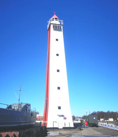
Lesnoy Range Rear Light, St. Petersburg, June 2008
Wikimedia Creative Commons photo by Larry Myhre

Kronstadt District (Kotlin Island) Lighthouses
Kronstadt (Кроншта́дт) is the historic home port of Russia's Baltic Fleet. The city and naval base are built on Kotlin Island, located 30 km (19 mi) west of St. Petersburg. The St. Petersburg Dam, a flood control structure also carrying the St. Petersburg Ring Road, extends from Kotlin Island to both sides of Neva Bay; completed in 2011, its purpose is to protect St. Petersburg from inundation by storm surges driven by westerly winds. Ships pass through this barrier via a floodgate just south of the island; a tunnel carries vehicular traffic under the floodgate.
Tolbukhin (2)
1810 (station established 1719). Active; focal plane 29 m (95 ft); white light, 3 s on, 9 s off. 30 m (98 ft) 2-stage round cylindrical old-style stone tower with lantern and gallery, painted white; lantern dome is red. 2-story keeper's house and other light station buildings. Semyon Zakharov's photo is at right, another good photo is available, Trabas has a photo, Peter Efimov has a photo, Huelse has a historic postcard view, and Bing has a satellite view. The original light, a wooden tower, was ordered by Peter the Great. The present tower, the oldest active lighthouse in northwestern Russia, was designed by A.D. Zakharov, a famous Russian architect. Located on a tiny island about 7 km (4 mi) west northwest of the western tip of Ostrov Kotlin, the island on which Kronstadt is located. Accessible only by boat. Site and tower closed. ARLHS ERU-070; Admiralty C4010; NGA 13012.
Neva Bay Floodgate Outer South Mole
2008. Active; focal plane 17 m (56 ft); two green flashes every 5 s. 10 m (33 ft) round cylindrical tower, painted green with a white horizontal band. Trabas has a photo and Google has a satellite view. Located on the south mole at the west entrance to the floodgate. Site and tower closed. Admiralty C4011; NGA 13021.
Neva Bay Floodgate Outer North Mole
2008. Active; focal plane 17 m (56 ft); two red flashes every 5 s. 10 m (33 ft) round cylindrical tower, painted red with a white horizontal band. Trabas has a photo and Google has a satellite view. Located on the north mole at the west entrance to the floodgate. Site and tower closed. Admiralty C4011.2; NGA 13021.1.
Neva Bay Floodgate Inner South Mole
2008. Active; focal plane 14 m (46 ft); two green flashes every 5 s. 10 m (33 ft) round cylindrical tower, painted green with a white horizontal band. Trabas has a photo, Roma Glintwine has a distant street view, and Google has a satellite view. Located on the south mole at the east entrance to the floodgate. Site and tower closed. Admiralty C4011.4; NGA 13022.
Neva Bay Floodgate Inner North Mole
2008. Active; focal plane 14 m (46 ft); two red flashes every 5 s. 10 m (33 ft) round cylindrical tower, painted red with a white horizontal band. Trabas has a photo, Roma Glintwine has a closeup street view, and Google has a satellite view. Located on the south mole at the east entrance to the floodgate. Site and tower closed. Admiralty C4011.6; NGA 13022.1.

Tolbukhin Light, July 2007
Flickr photo copyright Semyon Zakharov; used by permission
Litke East Range Rear
Date unknown. Inactive. 17 m (56 ft) round cylindrical metal tower, painted white with a black vertical stripe on the former range line. Google has a street view and a satellite view. Located on the south side of Kotlin Island just east of the ring road. Site and tower closed. ex-Admiralty C4013.1.
Morskoy Kanal Range Rear
1914. Active; focal plane 40 m (131 ft); long white flash every 6 s. 41.5 m (136 ft) octagonal tower with lantern and gallery. The lighthouse is unpainted gray concrete with black and white horizontal bands on the side facing the range line. A photo shows the daymark, Trabas's photo is a side view, Dmitry Mityushev has a 2020 photo, a photo of both range lights is available, and Google has a satellite view. The Morskoy Kanal (Морского канала, "Sea Channel") is the dredged channel through Neva Bay (Nevskaya Guba) from Kronstadt to St. Petersburg; the channel is ruler straight and has a length of about 28 km (17 mi). The Lesnoy Range in St. Petersburg guides eastbound traffic in the channel and the Morskoy Kanal Range lights guide westbound traffic. Located about 1 km (0.6 mi) southwest of Fort Kronshlot. Accessible only by boat. Site and tower closed. ARLHS ERU-050; Admiralty C4059.1; NGA 13048.1.
Fort Nikolai Range Front
1891. Inactive since the early 1920s. 16 m (52 ft) round cast iron tower with lantern and gallery, painted red, built just outside the walls of Fort Kronshlot (formerly Fort Nikolai). Alexandrina Petrenko's photo is at right, an excellent closeup and a second closeup are available, and Google has a satellite view. The current Fort Kronshlot Light was the rear light of this range. The light became unnecessary after the current Kronstadt Rear Light was built in the 1920s. It appears that the lighthouse has been maintained as a daybeacon, since it still stands on the range line. Located 180 m (200 yd) west of the Fort Kronshlot Light on a small island just west of the naval base, near the east end of Ostrov Kotlin. Accessible only by boat, but there are distant views from Kronstadt and from the civilian port of Lomonosov on the mainland 3 km (2 mi) to the south. ARLHS ERU-314.
Fort Kronshlot (Kronstadt Range Front)
1891. Inactive since 2008. 25 m (82 ft) round cast iron tower with lantern and gallery, painted red, built just outside the walls of Fort Kronshlot. Mikhail Pozdnyakov has a photo, another photo is available, and Google has a satellite view. Built by Peter the Great in 1704, Fort Kronshlot is the oldest of the many fortresses protecting Kronstadt and St. Petersburg. The range became obsolete when the channel was relocated through the Floodgate in 2008. Located on a small island just west of the naval base, near the east end of Ostrov Kotlin. Accessible only by boat, but there are distant views from Kronstadt and from the civilian port of Lomonosov on the mainland 3 km (2 mi) to the south. Site and tower closed. ARLHS ERU-046; ex-Admiralty C4012; ex-NGA 13016.
 

Fort Nikolai Range Front Light, Kronstadt, October 2012
Wikimedia Creative Commons photo by Alexandrina Petrenko
Kabotazhnaya Gavan Range Front
Date unknown. Active; focal plane 16 m (52 ft); red flash every 1.5 s. 15 m (49 ft) square skeletal tower, mounted on a square concrete pier. The entire lighthouse is enclosed by a wood daymark painted white on three sides and red with a black vertical stripe on the side facing the range line. Dmitry Ishanin has a photo, Trabas has a closeup photo, and Google has a satellite view. This light is a front range light that guides naval vessels as they enter the Kronstadt naval station. Located about 600 m (0.4 mi) north of Fort Kronshlot. Accessible only by boat. Site and tower closed. Admiralty C4020; NGA 13024.
* Kabotazhnaya Gavan Range Rear (Petrovskaya Pristan)
Date unknown. Active; focal plane 31 m (102 ft); quick-flashing red light. 29 m (95 ft) square steel frame tower, faced with wood siding, with lantern and gallery. Lighthouse painted white, except the side facing the range is painted red with a black vertical stripe on the range line; lantern painted red. Alexander Platz's photo is at right, Trabas has a photo, Vladimir Petrukovich has a nice photo, Mikhail Shishov has a street view, and Google has a satellite view. The lighthouse was repainted in 2007. This light is a rear range light that guides naval vessels as they enter the Kronstadt naval station. The lighthouse stands on the Petrovskaya Pristan (mole), one of the breakwaters protecting the main harbor of Kronstadt, the traditional and historic home port of the Russian Navy. Accessible by walking the pier. Site open, tower closed. ARLHS ERU-144; Admiralty C4020.1; NGA 13024.1.
Bronka Exit (Bronka-3) Range Front
Date unknown. Active; focal plane about 10 m (33 ft); light characteristic unknown. Approx. 10 m (33 ft) round cylindrical white tower, carrying a large slatted daymark, on a concrete platform supported by concrete piles. Trabas has a photo and Google has a satellite view. The guides ships leaving the Bronka harbor in Lomonosov (see below). Located about 800 m (1/2 mi) southeast of Fort Kronshlot. Accessible only by boat. Site and tower closed. Admiralty C4042.4.
Bronka Exit (Bronka-3) Range Rear
Date unknown. Active; focal plane about 20 m (66 ft); light characteristic unknown. Approx. 20 m (66 ft) round cylindrical white tower, carrying a large slatted daymark, on a concrete platform supported by concrete piles. Trabas has a photo and Google has a satellite view. Located about 300 m (0.2 mi) northeast of the front light. Accessible only by boat. Site and tower closed. Admiralty C4042.41.
Lomonosov Approach (Bronka-2) Range Front
Date unknown. Active; focal plane about 10 m (33 ft); light characteristic unknown. Approx. 10 m (33 ft) round cylindrical white tower with a red vertical stripe, carrying a large slatted daymark, on a concrete platform supported by concrete piles. Trabas has a photo and Google has a satellite view. Despite the Bronka designation this range appears to lead toward the older Lomonosov harbor to the east of Bronka. Located about 1.6 km (1 mi) south southeast of Fort Kronshlot. Accessible only by boat. Site and tower closed. Admiralty C4042.5.

Kabotazhnaya Gavan Range Rear Light, Kronstadt, March 2021
Google Maps photo by Alexander Platz
Lomonosov Approach (Bronka-2) Range Rear
Date unknown. Active; focal plane about 20 m (66 ft); light characteristic unknown. Approx. 20 m (66 ft) round cylindrical white tower with a red vertical stripe, carrying a large slatted daymark, on a concrete platform supported by concrete piles. Trabas has a photo and Google has a satellite view. Located about 200 m (1/8 mi) south southeast of the front light. Accessible only by boat. Site and tower closed. Admiralty C4042.51.
Morskoy Kanal Range Front
1914. Active; focal plane 19 m (62 ft); quick-flashing white light. 20 m (66 ft) octagonal concrete tower with lantern and gallery, recently repainted white with a black vertical stripe on the range line; lantern roof painted red. Dmitriy Ossipoff has the 2021 photo at right, Trabas has a closeup photo, a photo of both range lights is available, and Google has a satellite view. Perhaps endangered, the lighthouse has a distinct lean. Located about 1.6 km (1 mi) southwest of the Kronstadt lighthouse. Accessible only by boat. Site and tower closed. ARLHS ERU-049; Admiralty C4059; NGA 13048.
Sredney Gavan' Range Front
2008 (?). Active; focal plane 16 m (52 ft); quick-flashing red light, visible only on the range line. 12 m (39 ft) square cylindrical skeletal tower; the front of the tower is covered by a daymark colored white with a red vertical stripe. Trabas has Klaus Kern's photo and Google has a satellite view. This range guides eastbound vessels through the Floodgate. Located on a detached breakwater south of the naval harbor. Site and tower closed. Admiralty C4036; NGA 13020.
Sredney Gavan' Range Middle
2008 (?). Active; focal plane 29 m (95 ft); quick-flashing red light, visible only on the range line. 25 m (82 ft) triangular cylindrical skeletal tower; the front of the tower is covered by a daymark colored white with a red vertical stripe. Trabas has a closeup photo and Google has a satellite view. Located about 400 m (1/4 mi) north of the Lomonosov Kanal Range Rear lighthouse (next entry). Site and tower closed. Admiralty C4036.1; NGA 13020.1.

Morskoy Kanal Range Front Light, Kronstadt, February 2021
Google Maps photo by Dmitriy Ossipoff
Lomonosovskogo (Lomonosovskiy Kanal) (Range Rear)
1915. Active; focal plane 54 m (177 ft); continuous green light shone only to the south. 54 m (177 ft) octagonal concrete tower with lantern and gallery. Tower is unpainted gray concrete; lantern painted red. One of Dmitry Rostopshin's photos is at right, Jessica Brach has a 2007 photo, Trabas has a photo, a 2021 photo and another photo are available, Peter Efimov has a closeup, and Google has a good satellite view. Since 2009 this is no longer a range light; it is a directional light guiding vessels leaving Lomonosov. Located near the east end of the naval harbor at Kronstadt, about 2.3 km (1.5 mi) east southeast of the front light at Fort Kronshlot. Site and tower closed but there are good views from shore and distant views from the civilian port of Lomonosov on the mainland 3 km (2 mi) to the south. ARLHS ERU-047; Admiralty C4012.1; NGA 13040.
Voyennaya Gavan (Voennogo Ugla, Friedrichstadt'skiy, Kronstadt'skiy)
1863. Active; focal plane 14 m (46 ft); white light, 2 s on, 2 s off. 11.5 m (38 ft) hexagonal cylindrical cast iron skeletal tower, painted red. Trabas has a photo and Google has a satellite view. The lantern was removed in 1938. The lighthouse was originally named for the 18th century warship Friedrichstadt. It was recognized as a cultural heritage site in 2001. Located at the corner of a pier at the extreme southeastern tip of the Kronstadt naval base, about 400 m (1/4 mi) southwest of the Lomonosov Kanal lighthouse. Site and tower closed. Admiralty C4042; NGA 13036.
#Kronstadt Fairway No. 15 (Summer Harbor) Range Rear
Date unknown. Demolished in 2019. This was a 16 m (52 ft) round tower, painted white with a black vertical stripe. Google has a 2013 street view and Bing has a satellite view. Located about 300 m (1000 ft) west of the front light. Site status unknown. ex-Admiralty C4042.21; NGA 13044.1.
Kronstadt Fairway No. 15 (Summer Harbor) Range Front
Date unknown. Inactive but listed with focal plane 14 m (46 ft); continuous green light. 12 m (39 ft) round tower, painted white with a black vertical stripe. Trabas has a photo and Google has a 2013 street view and a satellite view. Located at the eastern tip of Kotlin Island. Site status unknown. Admiralty C4042.2: NGA 13044.
Sredney Gavan' Range Rear
Date unknown. Active; focal plane 47 m (154 ft); quick-flashing red light, visible only on the range line. 40 m (131 ft) tapered round tower with gallery; the tower carries a slatted daymark painted white with a red vertical stripe. Trabas has a closeup photo and Google has a satellite view. Located about 4 km (2.5 mi) east of Kotlin Island. Accessible only by boat. Site open, tower closed. Admiralty C4036.2; NGA 13020.2.
Kronshtadt Range Rear Light
Lomonosovskiy Kanal Range Rear Light, Kronstadt
ex-Panoramio photo copyright Dmitry Rostopshin; used by permission
Ostrov Krasnoarmeyskiy (1?)
Date unknown. Abandoned but still listed by the Admiralty. Approx. 8 m (26 ft) square skeletal tower. A photo is available and Bing has a satellite view. There may be a modern light nearby; Navionics charts a red light. Located on a ridge next to the ruined Fort Krasnoarmeyskiy on the artficial island, about 3 km (2 mi) north of Kotlin Island. Accessible only by boat. Site open, tower closed. Admiralty C4080.

Petrodvortsovy District: Lomonosov Area Lighthouses
Lomonosov (Ломоно́сов), called Oranienbaum until 1948, is a port on the south side of Neva Bay west of Peterhof and opposite the naval base of Kronstadt. Although Lomonosov is the administrative seat of the Lomonosov District of Leningrad Oblast, the town itself has been annexed to the federal city of Saint Petersburg and is therefore not part of Leningrad Oblast.
Malaya Ishora (Bronka) Range Front
Date unknown. Active; focal plane 18 m (59 ft); red light occulting once every 2.5 s. 15 m (49 ft) square cylindrical skeletal tower carrying a rectangular daymark painted white with a black vertical stripe. Google has a satellite view and a distant street view. This the eastern range for the Bronka harbor just east of the Ring Road. Located just east of the Kronstadt bridge in Lomonosov. Site and tower closed, but there's a good view from the northbound Ring Road. Admiralty C4044.
Malaya Ishora (Bronka) Range Rear
Date unknown. Active (?); focal plane 23 m (75 ft); red light occulting once every 2.5 s. 20 m (66 ft) square cylindrical skeletal tower, painted red. The tower carries a slatted daymark painted white with a black vertical stripe. Google has a street view and a satellite view. Located about 300 m (1000 ft) south of the front light, inside the loop of a ramp connecting the Ring Road to the A121 highway. Site and tower closed. Admiralty C4044.1.
Oranienbaum (Lomonosov East Pierhead)
1875. Inactive. Approx. 8 m (26 ft) square light tower with gallery attached to a 1-story harbormaster's office. The lantern has been replaced by a pyramidal roof. A closeup is available and Google has a street view and a satellite view. Endangered: this historic building has been abandoned. Located at the end of the east breakwater pier of Lomonosov harbor. Site status unknown.
* Lomonosov (Fairway Number 7) Range Front
Date unknown. Active; focal plane 19 m (62 ft); continuous red light. 14 m (46 ft) round cylindrical tower with gallery; the tower carries side panels as a daymark. Lighthouse painted white with red vertical stripes. Dmitry Rostopshin's photo is at right, Trabas has Klaus Kern's closeup photo, another photo is available, and Google has a street view and a satellite view. This the main approach range for Lomonosov. Located near the base of the east breakwater pier of Lomonosov harbor. Site open, tower closed. Admiralty C4047; NGA 13052.
Lomonosov (Fairway Number 7) Range Rear
Date unknown. Active; focal plane 30 m (98 ft); continuous red light. 28 m (92 ft) steel post with side panels providing a daymark. Lighthouse painted white with red vertical stripes. Trabas has Klaus Kern's photo, and the shadow of the tower is seen in Google's satellite view. Located on a broad quay on the east side of Lomonosov. Site probably open, tower closed. Admiralty C4047.1; NGA 13052.1.
Lomonosov Range Front Light
Lomonsov Range Front Light, 2008
ex-Panoramio photo copyright Dmitry Rostopshin
used by permission
Sidorovskiy Kanal (Fairway Number 8) Range Rear
Date unknown. Active; focal plane 19 m (62 ft); green light, 2 s on, 1 s off, visible only on the range line. 18 m (56 ft) square cylindrical skeletal tower; the front of the tower is covered by a slatted daymark painted white with a black vertical stripe. Trabas has a view from the bay and Google has a street view and an indistinct satellite view. The front light is on a post. Located about 200 m (220 yd) southwest of the front light. Site probably open, tower closed. Admiralty C4048.1; NGA 13054.1.

Petrodvortsovy District: Strel'na and Petrodvorets (Peterhof) Lighthouses
Strel'na and Petergof (also called Petrodvorets or, in English and German, Peterhof) are smaller municipalities southwest of St. Petersburg on the south shore of Neva Bay. Both are the sites of large tsarist palaces, now museums attracting large numbers of tourists.
* Petergof (Petrodvorets) East Approach Range Rear
Date unknown. Active; focal plane 20 m (66 ft); white light occulting once every 3 s. 18 m (59 ft) square skeletal tower mounted on a 1-story equipment shelter. The tower is painted red and carries a slatted daymark painted white with a black vertical stripe. Trabas has a photo by Thomas Philipp and Google has a street view and a satellite view. Located in Petergof about 300 m (1000 ft) west of the small boat harbor. Site open, tower closed. Admiralty C4051; NGA 13056.1.
 
* Petergof (Petrodvorets) Range Common Front
Date unknown. Active; focal plane 6 m (20 ft); quick-flashing white light. 4 m (13 ft) concrete tower attached to a rectangular 1-story structure topped by an observation deck. Lighthouse painted white with red vertical stripes. Trabas has a photo by Thomas Philipp, Varvara Soboleva has a closeup street view, and Google has a street view and a satellite view. This light is the front light for both the east and west ranges. Located at the end of the breakwater pier sheltering the small boat harbor at Petergof. Accessible by walking the pier. Site open, tower probably open. Admiralty C4050; NGA 13056.
* Petergof (Petrodvorets) West Approach Range Rear
1887. Active; focal plane about 11 m (36 ft); white light, 1.5 s on, 1.5 s off. Approx. 10 m (33 ft) round cylindrical cast iron (?) tower with lantern, gallery, and skeletal braces on the seaward side. Tower painted white, lantern and watch room red, and there is a white-bordered red vertical stripe shone on the range line. Trabas has a photo by Douglas Cameron (also seen at right), Pavel Galishev has a 2017 photo, Maria Ku has a 2018 photo, Lightphotos.net has a page for the lighthouse, Larry Myhre has a photo, and Google has a street view, but trees shadow the light in Google's satellite view. Thanks to its location on the grounds of the Imperial palace this small lighthouse is often photographed. Located in Petergof below the palace and about 200 m (600 ft) east of the small boat harbor. Site open, tower closed. Site manager: Petergof State Museum-Reserve. ARLHS ERU-317; Admiralty C4052; NGA 13056.2.
Petrovskiy Kanal Range Rear
2007. Active; focal plane 30 m (98 ft); red light, 3 s on, 3 s off. 25 m (82 ft) round cylindrical tower with gallery, mounted on an octagonal concrete platform supported by piles. Lighthouse painted white with a red vertical stripe. Trabas has a photo and Google has a satellite view. This range guides vessels in the Petrovskiy Channel used by vessels leaving the Gutuevskaya docks on the central St. Petersburg waterfront. Located about 3 km (2 mi) northeast of the Petergof waterfront. Accessible only by boat. Site open, tower closed. Admiralty C4076.611; NGA 13076.1.

Petrodvorets West Range Rear Light, Petergof
photo copyright Douglas Cameron; used by permission
Petrovskiy Kanal Range Front
2007. Active; focal plane 15 m (49 ft); red light, 3 s on, 3 s off, visible only on the range line. 10 m (30 ft) round cylindrical tower with gallery, mounted on an octagonal concrete platform supported by piles. Lighthouse painted white with a red vertical stripe. Trabas has a photo and Google has a satellite view. Located about 1.7 km (1.1 mi) northeast of the rear light. Accessible only by boat. Site open, tower closed. Admiralty C4076.61; NGA 13076.
* Strel'na Range Front
Date unknown. Active; focal plane 13 m (43 ft); green light occulting once every 3 s. 10 m (33 ft) square cylindrical skeletal tower mounted on a triangular concrete base. Tower painted black, base white; the tower also carries a slatted daymark painted white with a red vertical stripe. Trabas has a photo, Roman Volkov has a distant street view, and Google has a satellite view. Located at the end of the west breakwater at Strel'na. Probably accessible by walking the pier. Site open, tower closed. Admiralty C4063; NGA 13058.
* Strel'na Range Rear
Date unknown. Active; focal plane 28 m (92 ft); green light occulting once every 3 s. 25 m (82 ft) triangular skeletal tower mounted on a triangular concrete base. Tower painted black, base white; the tower also carries a rectangular daymark consisting of two white vertical panels with a red vertical panel in the center. Trabas has a photo showing both lights and Google has a street view and a satellite view. Located behind the parking lot of the small boat harbor at Strel'na. Site open, tower closed. Admiralty C4063.01; NGA 13058.1.

Kirovsky District (Downtown St. Petersburg) Lighthouses
Lesnoy Mole Range Front
Date unknown. Active; focal plane 21 m (69 ft); red light, 2 s on, 1 s off. 16 m (52 ft) square cylindrical skeletal tower, painted black. The upper 2/3 of the west side of the tower carries a slatted daymark, painted red with a black vertical stripe. Capt. Peter Mosselberger's photo is at right, Trabas has a photo and Google has a satellite view. The range guides ships from the Morskoy Kanal into the commercial harbor of St. Petersburg, on the south side of the city. Located at the end of the Lesnoy docks on the St. Petersburg waterfront. Site and tower probably closed to the public. Admiralty C4062; NGA 13062.
Lesnoy Mole Range Middle
Date unknown. Active; focal plane 26 m (85 ft); green light, 3 s on, 2 s off. 24 m (79 ft) square skeletal tower, painted black. Trabas has a photo and Google has a satellite view. Located at the west end of the containership port; site and tower probably closed to the public. Admiralty C4062.05; NGA 13062.1.
Lesnoy Mole Range Rear
Date unknown. Active; focal plane 76 m (249 ft); red light occulting once every 4 s. 73 m (239 ft) round tower with lantern and several galleries, painted with red and white horizontal bands. Larry Myhre's photo is at the top of this page, Trabas has a photo, Lightphotos.net has a page with an excellent photo, and the long shadow of the tower is conspicuous in this Google satellite view. This remarkable and nearly-unknown tower is the tallest Russian lighthouse and one of the tallest lighthouses in the world. Located in a dockyard area on the waterfront; site and tower probably closed to the public. Admiralty C4062.2; NGA 13062.2.
Korabel'nyy Kanal (Leading Light)
Date unknown. Active; continuous white, red or green light depending on direction. The original focal plane was 68 m (223 ft) but the modern light is mounted low on the tower at a focal plane of about 16 m (52 ft). Approx. 60 m (200 ft) round tower, painted with red and white horizontal bands. Wikimedia has Natalya Semenova's photo, a 2021 photo is available, Trabas has a closeup photo of the active light, and Google has a street view and a satellite view. This is a leading light guiding vessels approaching on the Korabel'nyy Channel. Located on a quay in the Gutuevskaya docks on the St. Petersburg waterfront. Site and tower probably closed to the public. Admiralty C4074.2; NGA 13072.
Podkhodnogo Kanala Range Front
Date unknown. Active; focal plane 16 m (52 ft); green light, 3 s on, 3 s off, visible only near the range line. 13 m (43 ft) round cylindrical tower, painted white with a red vertical stripe and mounted on a concrete pier. Trabas has Jim Smith's photo and Google has a satellite view. The range guides vessels leaving the St. Petersburg docks on the Podkhodnogo Channel. Located about 3.5 km (2 mi) off the Vasileostrovskiy waterfront. Accessible only by boat. Site open, tower closed. Admiralty C4076.45; NGA 13077.5.

Lesnoy Mole Range Front Light
photo copyright Capt. Peter Mosselberger; used by permission
Podkhodnogo Kanala Range Rear
Date unknown. Active; focal plane 21 m (62 ft); green light, 3 s on, 3 s off, visible only near the range line. 18 m (59 ft) round cylindrical tower, painted white with a red vertical stripe and mounted on a concrete pier. Trabas has Jim Smith's photo and Google has a satellite view. Located 500 m (0.31 mi) west of the front light. Accessible only by boat. Site open, tower closed. Admiralty C4076.451; NGA 13077.51.
* Ostrov Krestovskiy Range Front
Date unknown. Active; focal plane 14 m (46 ft); continuous red light, visible only near the range line. 12 m (39 ft) round cylindrical tower, painted white with a red vertical stripe. Aaron Bogott has a closeup street view, Nikolay Nikolayevich has a remarkable street view taken from one of the cable towers of the Krestovskiy Bridge, and Google has a satellite view. This range guides vessels inbound on the Petrovskiy Channel. Krestovskiy Island is at the northwestern corner of the Neva delta in St. Petersburg. Located beside a waterfront boulevard on the southwestern side of the island and on the south side of the new Krestovskiy Stadium. Site open, tower closed. Admiralty C4076.5; NGA 13077.
* Ostrov Krestovskiy Range Rear
Date unknown. Active; focal plane 18 m (59 ft); continuous red light, visible only near the range line. 17 m (56 ft) round cylindrical tower, painted white with a red vertical stripe. Google has a closeup street view and a satellite view. Located on the east side of the new Krestovskiy Stadium, 310 m (340 yd) east northeast of the front light. Site open, tower closed. Admiralty C4076.51; NGA 13077.1.
* St. Petersburg Rostral Columns
1811. Inactive as aids to navigation. Two ornate red columns with galleries, topped by gas burners on tripods and decorated with six ship's prows. Lights were displayed at the tops of the towers during the nineteenth century and decorative gas lights are lit there on special occasions today. A photo of one of the columns is at right, Wikipedia has an article with several photos, Huelse has a historic postcard view, Arten Yatskiv has a street view, and Google has a satellite view. The columns were originally lit with oil; they have never had modern lamps. Located at the eastern end of Vasilievski Island in downtown St. Petersburg, where the Neva River divides into two channels as it approaches the Gulf of Finland. Site open, towers closed. Site manager: City of St. Petersburg. ARLHS ERU-311.

Rostral Column on Navy Day, St. Petersburg, 29 July 2018
Wikimedia Creative Commons photo by Damien

Kurortny District: Zelenogorsk Lighthouses
* Zelenogorskaya Gavan' Range Front (3?)
Date unknown. Listed as active; focal plane 9 m (30 ft); red light, 2 s on, 2 s off. 5 m (17 ft) round cylindrical tower with lantern, painted orange with a white vertical stripe on the range line. A 2020 photo is available and Google has a satellite view and a distant street view from a beach to the west. Zelenogorsk (Terijoki in Finnish) is a town on the north side of the westernmost Gulf of Finland, about 50 km (30 mi) northwest of downtown St. Petersburg. The small harbor here had been abandoned, but it recent years it has been redeveloped as an upscale resort and yacht harbor. It appears that the range lights were moved, perhaps several times, as this development proceeded. Wikimedia's 2007 photo of the harbor shows the light standing next to hotels under construction. Located on the wharf of the Terijoki Yacht Club. Site open, tower closed. Site manager: Terijoki Hotel and Spa. RU 2201-1706; Admiralty C4081.5.
* Zelenogorskaya Gavan' Range Rear
Date unknown. Listed as active; focal plane 16 m (52 ft); red light, 2 s on, 2 s off. 12 m (39 ft) round cylindrical tower with lantern, painted orange with a white vertical stripe on the range line. A 2019 closeup photo and a March 2019 street view from a snow-covered beach is available and Google has a satellite view. Located behind the hotel. Site open, tower closed. Site manager: Terijoki Hotel and Spa. RU 2201-1707; Admiralty C4081.51.

Information available on lost lighthouses:

Notable faux lighthouses:

Adjoining pages: North: Vyborg Area | East: Lake Ladoga | Southwest: Eastern Estonia | West: Ingria

Return to the Lighthouse Directory index | Ratings key

Posted May 22, 2005. Checked and revised July 29, 2023. Lighthouses: 48. Site copyright 2023 Russ Rowlett and the University of North Carolina at Chapel Hill.