Lighthouses of Southeastern Finland: Kymenlaakso

The Republic of Finland (Suomi in Finnish) is a country of northern Europe with coastlines facing south on the Gulf of Finland (Suomenlahti) and west on the Gulf of Bothnia (Pohjanlahti), both arms of the Baltic Sea. Finland also administers the Åland Islands (Ahvenanmaa), an archipelago at the junction of the two gulfs. After centuries of rule by Sweden, Finland was conquered by Russia in 1809 and became an autonomous grand duchy within the Russian Empire. The country declared its independence from Russia at the start of the Russian Revolution in 1917. It lost some of its eastern territory to Russia as a result of World War II but has retained its independence.

Finland is divided into nineteen regions (maakunta) and the regions are divided into municipalities (kunta). This page describes the lighthouses of the Kymenlaakso ("Kymi Valley") Region. This includes the Gulf of Finland coastline from the Russian border through the Kotka area.

The Finnish word for a lighthouse is majakka (plural majakat). Saari is an island, luoto is an islet or skerry, niemi is a cape or headland, niemimaa is a peninsula, lahti is a bay, salmi is a strait, joki is a river, and satama is a port or harbor. Swedish is a second official language in Finland and some of the lighthouses are commonly known by their Swedish names.

Lighthouses in Finland are maintained by the Waterways Section of the Finnish Transport Infrastructure Agency (Liikennevirasto).

ARLHS numbers are from the ARLHS World List of Lights. SU numbers are from the official Finnish light list, Suomen rannikon loistoluettelo. Admiralty numbers are from volume C of the Admiralty List of Lights & Fog Signals. U.S. NGA List numbers are from Publication 116.

General Sources
Online List of Lights - Finland
Photos by various photographers posted by Alexander Trabas.
Finskt fyrväsende
Photos and information posted by the Swedish Lighthouse Society.
Finnish Lighthouses
Excellent photos of the some of the better known lighthouses, posted to Flickr by Mikko Rauhala.
Lighthouses in Finland
Photos by various photographers available from Wikimedia, including a very large collection of historic black-and-white photos.
World of Lighthouses - Finland
Photos by various photographers available from Lightphotos.net.
Finland Lighthouses
Aerial photos posted by Marinas.com.
Weitere Europäische Leuchttürme auf historischen Postkarten
Historic postcard images posted by Klaus Huelse.
Finnish Lighthouse Society (Suomen Majakkaseura)
The national lighthouse preservation association.
List of Lights
The Finnish light list is available for download.
GPSNauticalCharts
Navigational chart for southeastern Finland.
Navionics Charts
Navigational chart for southeastern Finland.


Kotka Light, Gulf of Finland, June 2020
Google Maps photo by Paavo Juntunen
Virolahti Municipality Lighthouses
Parrio
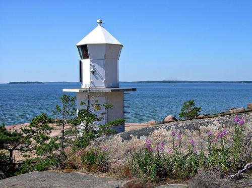
Date unknown (station established 1938). Active; focal plane 9 m (30 ft); two flashes every 6 s, white, red or green depending on direction. 6 m (20 ft) octagonal concrete tower with lantern, painted white. Google has a closeup photo (also seen at right) and a distant satellite view. This directional light guides vessels following a complex inside passage along the coast. There were range lights here at least by the 1920s. Located on the southwest coast of Parrio, an island about 1 km (0.6 mi) northwest of the Russian border. Accessible only by boat. Site open, tower closed. SU 215; Admiralty C5468; NGA 13320.
Järviluoto Range Rear
Date unknown. Active; focal plane 21 m (69 ft); white light, 2 s on, 4 s off. 20 m (66 ft) triangular skeletal tower carrying a daymark painted white with a black vertical stripe. Trabas has a photo and Google has an indistinct satellite view. This directional light guides westbound vessels following the inside passage. The front light is on an 11 m (36 ft) billboard tower. Located in the entrance to the fjord leading to Hailila, about 7 km (4.5 mi) southwest of Virolahti. Accessible only by boat. Site status unknown. SU 23754; Admiralty C5466.11; NGA 13324.1.
Siikasaari
Date unknown. Active; focal plane 11 m (36 ft); white light, 2 s on, 4 s off. 9 m (30 ft) rectangular wood skeletal tower; the front of the tower is covered by a corrugated white daymark. Trabas has a photo but the light is not seen in Google's satellite view. This directional light (originally the front light of a range) guides eastbound vessels following the inside passage. Located on a low promontory southwest of the Järviluoto range lights. Accessible only by boat. Site status unknown. SU 213; Admiralty C5465.9; NGA 13332.

Parrio Light, Virolahti, July 2005
Google Maps photo contributed by Ysmael Maseta
Mustamaa
Date unknown. Active; focal plane 7 m (23 ft); quick-flashing light, white, red or green depending on direction. 6 m (20 ft) round tower, painted white. No photo available but Google has a distant satellite view. There are sectors for both eastbound and westbound vessels on this directional light. Located at the southwest coast of Mustamaa, an island about 11 km (7 mi) west of Parrio. Accessible only by boat. Site open, tower closed. SU 352; Admiralty C5464; NGA 13348.
Lotouri
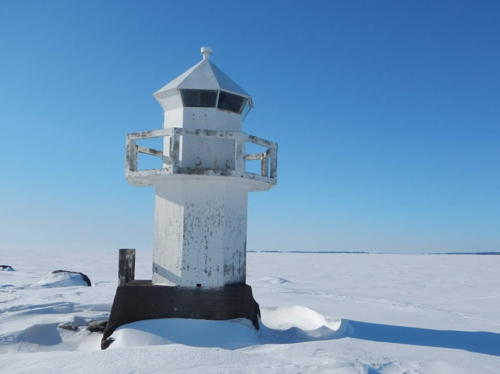
Date unknown (station established 1937). Active; focal plane 5.5 m (18 ft); two flashes every 6 s, white, red or green depending on direction. 6 m (20 ft) octagonal concrete tower with lantern, painted white. A wintry closeup photo is at right and Google has a distant satellite view. Located on a tiny island on the south side of the inside passage about 25 km (15 mi) southeast of Hamina. Accessible only by boat. Site open, tower closed. SU 211; Admiralty C5456; NGA 13352.

Hamina Municipality Lighthouses
Hamina, known as Fredrikshamn under Swedish rule, is a historic seaport located 145 km (90 mi) east of Helsinki. It has a population of about 20,000.

Kuorsalo Range Rear
Date unknown. Inactive since 2023. Approx. 25 m (82 ft) skeletal tower. No photo available but Google has a distant satellite view. This range guided eastbound vessels on a northeast reach of the inside passage. The rear light was deactivated when the front light was changed to a directional light. Located in a forest near the center of the island of Kuorsalo. Site status unknown. SU 209; Admiralty C5438.61; NGA 13390.

Lotouri Light, Virolahti, March 2013
Google Maps photo by viherlandia
Västäri Range Rear
Date unknown. Active; focal plane 24 m (79 ft); white light, 2 s on, 4 s off. 22 m (72 ft) skeletal tower. No photo available but Google has an indistinct satellite view. The range guides vessels departing Hamina. NGA misspells the name as Vatiniki. Located on Ristinkari, an island on the east side of Västäri. Accessible only by boat. Site open, tower closed. SU 210; Admiralty C5438.71; NGA 13398.4.
Tammio Range Rear
Date unknown. Active; focal plane 20 m (66 ft); white light, 2 s on, 6 s off. 19 m (62 ft) skeletal tower. No photo available but Google has an indistinct satellite view. The range guides vessels on an outer approach from the Gulf of Finland to the start of the inside passage. Located on the west side of Tammio. Accessible only by boat. Site open, tower closed. SU 205; Admiralty C5438.51; NGA 13401.5.
Houtere Range Rear
Date unknown. Active; focal plane 24 m (79 ft); yellow light, 2 s on, 4 s off. 24 m (79 ft) skeletal tower. No photo available but Google has an indistinct satellite view. This range guides vessels departing Hamina. Located on a small island off the south coast of the island of Houtere. Accessible only by boat. Site open, tower closed. SU 218; Admiralty C5438.81; NGA 13396.
Vatinki Range Rear
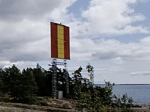
Date unknown. Active; focal plane 26 m (85 ft); yellow light, 2 s on, 4 s off. 24 m (79 ft) skeletal tower carrying a large daymark panel colored red with a yellow vertical stripe. Juha Hovilainen has the street view seen at right and Google has an indistinct satellite view. NGA misspells the name as Vatiniki. The range guides vessels on an outer approach from the Gulf of Finland to the start of the inside passage. Located on Aarholma, a small island about 6 km (3.5 mi) southwest of Houtere. Accessible only by boat. Site open, tower closed. SU 204; Admiralty C5438.41; NGA 13399.8.

Vatinki Range Rear Light, Houtere, October 2015
Google Maps street view by Juha Hovilainen
Suntholma (Suntholmit, Sunholma)
Date unknown. Active; focal plane 16 m (52 ft); five quick white flashes every 6 s. 14 m (46 ft) square stone cairn, painted white with a red horizontal band. No photo available but Google has a satellite view. This leading light guides westbound vessels leaving the inside passage for the Gulf of Finland. Located on the northwestern point of the island of Suntholmit, about 25 km (15 mi) south of Hamina. Accessible only by boat. Site open, tower closed. SU 350; Admiralty C5438.58; NGA 13402.
Velperkari
Date unknown. Active; focal plane 8 m (26 ft); five quick white flashes every 5 s. 7 m (23 ft) octagonal concrete tower with lantern and gallery. Entire lighthouse is white. Two photos are available and Juha Hovilainen has a street view, but the white lighthouse is hard to find in Google's snow-covered satellite view. Located on a small island about 1.5 km (1 mi) west of Suntholma. Accessible only by boat. Site open, tower closed. SU 75687; Admiralty C5438; NGA 13400.
*** Majakkalaiva (Lightship) Kotka (Helsinki, Hyöky, Libauskiy)
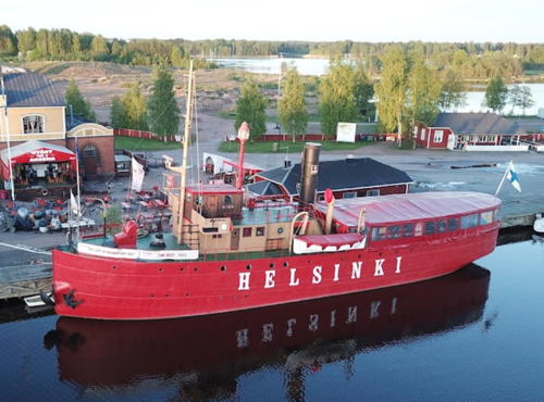
1912. Inactive as a lightship since 1959. 42.5 m (140 ft) steel lightship; the light was shown from a mast on the pilothouse. Hull and mast painted red, superstructure buff and white. A photo is at right, Wikipedia has a closeup photo by Kari Jokinen, and a good 2008 photo is available. The ship was built for the Russian Navy by the Putilov shipyard in St. Petersburg. Its first assignment was as the Libauskij off Libau (now Liepaja) in Latvia. Captured as a war prize by Finland following World War I, the ship served the Relandersgrund and Äransgrund stations and then the Helsinki station from 1933 to 1959. In 1961 it was renamed Hyöky and converted to a hydrographic support ship. Retired in 1983, it was restored as a floating restaurant and museum. In 2012 it was for sale at auction and by 2013 it was in Hamina seeking a new restaurant manager. Stefan Thomasson has a 2016 photo of the ship at Hamina, Kimmo Mäenpää has the 2018 photo seen at right, a 2021 street view shows the ship now with Kotka as the name on the hull, and Google has a satellite view. Moored at Tervasaari in the harbor of Hamina. Site and vessel open. Site manager: S.S. Hyöky . ARLHS FIN-027.

Lightship Helsinki, Hamina, May 2018
Google Maps photo by Kimmo Mäenpää

Kotka Municipality Lighthouses
Kotka is a town of about 51,000 residents; like Hamina it faces a broad, island-strewn embayment of the Gulf of Finland. The Port of Hamina-Kotka is the major port of southeastern Finland, exporting timber, paper and pulp and receiving containerships and bulk carriers.

Veitkari
Date unknown. Active; focal plane 10 m (33 ft); two quick flashes every 6 s. 5 m (16 ft) lantern on an octagonal concrete base. Entire lighthouse is white. The light has been raised on a mast atop the lantern. Several photos are available and Google has a distant satellite view. Despite its small size this is an important light at the beginning of the approach to Kotka. Located on an islet about 23 km (14 mi) south of Kotka. Accessible only by boat. Site open, tower closed. SU 323; Admiralty C5412; NGA 13404.
Kivikari
Date unknown. Active; focal plane 8 m (26 ft); quick-flashing light, white, red or green depending on direction. 7 m (23 ft) lantern and gallery mounted on a square stone base. A photo is available (second photo on the page) and Google has a satellite view. This light guides vessels in the Kivikari Channel, a narrow passage between islands. Located across from the inhabited island of Haapasaari. Accessible only by boat. Site open, tower closed. SU 206; Admiralty C5410; NGA 13412.
Keskihallinkari
Date unknown. Active; focal plane 20 m (66 ft); one long white flash every 6 s. 20 m (66 ft) steel mast, painted white with a red horizontal band and mounted on a robust square base. Two photos are available (1/3 the way down the page) and the shadow of the mast is seen in Google's satellite view. This is a directional light visible only to vessels departing Kotka eastbound. Located on a rocky shoal about 20 km (13 mi) southeast of Kotka. Accessible only by boat. Site open, tower closed. SU 345; Admiralty C5414.3; NGA 13414.
Märäkari (Merikari)
Date unknown. Active; focal plane 12 m (39 ft); five very quick red flashes every 6 s. 10 m (33 ft) triangular skeletal tower carrying a large black daymark. Two photos are available (halfway down the page) and Google has a satellite view. Located on a rocky shoal about 16 km (10 mi) southeast of Kotka. Accessible only by boat. Site open, tower closed. SU 170; Admiralty C5408; NGA 13542.
Kiviletto
Date unknown. Active; focal plane 19 m (62 ft); white light, 2 s on, 4 s off. 19 m (62 ft) steel mast, painted white with a red horizontal band and mounted on a robust square base. Two photos are available (near the top of the page), Juha Hovilainen has a closeup street view, and Google has a satellite view. This is a directional light visible only over the western outer approach channel to Kotka. Located on a rocky shoal about 25 km (15 mi) south of Kotka. Accessible only by boat. Site open, tower closed. SU 232; Admiralty C5381; NGA 13563.
Rankki
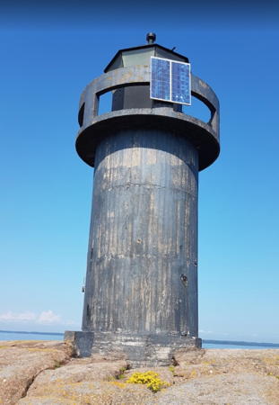
Date unknown (station established 1884). Active; focal plane 11 m (36 ft); three flashes every 10 s, white, red or green depending on direction. 8 m (26 ft) round concrete tower with lantern and gallery, painted black. A photo is at right, several photos are available (near the top of the page), Juha Hovilainen has a street view, and Google has a satellite view. The white sectors of this guide vessels eastbound or westbound parallel to the coast near Kotka. Located on a skerry off the southeastern tip of Rankki, about 3 km (2 mi) west of the island of Kirkonmaa and 8 km (5 mi) southeast of Kotka. Accessible only by boat. Site open, tower closed. SU 168; Admiralty C5386; NGA 13564.
Hietakari
Date unknown. Active; focal plane 5 m (17 ft); flash every 3 s, white, red or green depending on direction. 6 m (20 ft) square tower with lantern and gallery, painted white. Several photos are available (1/5 the way down the page), Juha Hovilainen has a closeup street view, and Google has a satellite view. Located on a small island southeast of Lehmäsaari. Accessible only by boat. Site open, tower closed. SU 164; Admiralty C5390; NGA 13580.

Rankki Light, Kotka, June 2020
Google Maps photo by Maria E.
Lelleri (Lellerinsaaret)
Date unknown. Active; focal plane 5 m (16 ft); two flashes every 5 s, white, red or green depending on direction. 6 m (20 ft) square tower with lantern and gallery, painted red with a white vertical stipe. A good photo is available (second photo on the page) and Google has a distant satellite view. Located on a rock just off the east side of the islet of Pasko-Lelleri, about 800 m (1/2 mi) southwest of the southern tip of Lehmäsaari, an island southeast of Kotka. Accessible only by boat. Site open, tower closed. SU 163; Admiralty C5388; NGA 13584.
Lehmä (Viikari Range Rear)
Date unknown. Active; focal plane 37 m (121 ft); white light, 2 s on, 4 s off. Approx. 25 m (82 ft) square skeletal tower carrying a rectangular daymark painted red with a yellow vertical stripe. Trabas has a distant photo and Google has an indistinct satellite view. This range guides vessels approaching Kotka from the west parallel to the coast. Located on Lehmäsaari, an island southeast of Kotka. Accessible only by boat. Site status unknown. SU 129; Admiralty C5356.1; NGA 13696.
Lehmäsaari Range Rear
Date unknown. Active; focal plane 33 m (180 ft); white light, 2 s on, 4 s off. Approx. 25 m (82 ft) skeletal tower carrying a rectangular daymark painted red with a white vertical stripe. Trabas has a distant photo, a distant view (tenth photo on the page) is available, and Google has a satellite view. Located near the north end of Lehmäsaari, on the east side of the entrance to Kotka. Accessible only by boat. Site open, tower closed. SU 286; Admiralty C5394.41; NGA 13600.
Fort Slava (Kukouri Range Rear and Lehmäsaari Range Front)
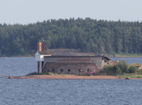
Date unknown. Active, with two range lights: Kukouri focal plane 18 m (56 ft); white light, 2 s on, 4 s off; Lehmasaari focal plane 14 m (46 ft), quick-flashing white light. 18 m (56 ft) triangular skeletal mast carrying rectangular daymarks for each range, both daymarks painted red with a white vertical stripe. Trabas has a photo, Marinas.com has aerial photos, a distant view is at right, and Google has an indistinct satellite view. Built by Russia in 1792 on a tiny islet in Kotka harbor, Fort Slava was blown up by British forces in 1855 during the Crimean War. The ruins are preserved as a national monument. Located just off the south side of the islet. Accessible only by boat. Site open, tower closed. Kukouri Range Rear: ex-Admiralty C5383.1; NGA 13571.1; Lehmasaari Range Front SU 133; Admiralty C5394.4; NGA 13596.

Fort Slava Light, Kotka, July 2013
Wikimedia public domain photo by MKFI
Pirköyri (2?)
Date unknown. Active; focal plane 6 m (20 ft); flash every 3 s, white, red or green depending on direction. 7 m (23 ft) square wood tower with lantern and gallery. Tower painted white, lantern orange. Trabas has a closeup photo and Google has a satellite view. The narrow white sector guides vessels leaving Kotka. Located off the southwestern shore of Pirköyri island, opposite the Kotka waterfront. Accessible only by boat. Site open, tower closed. SU 131; Admiralty C5394; NGA 13604.
* Majakkalaiva (Lightship) Kemi
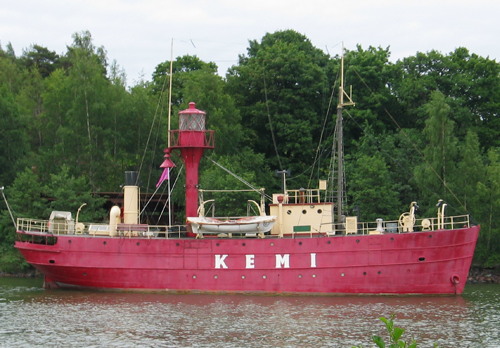
1901 (Pori Engine Shop). Decommissioned 1974. 30 m (98 ft) steel lightship. The light was shown from a lantern atop a light tower in the aft portion of the ship. Vessel painted red. An older photo is at right, Esko Kurvinen has a closeup photo, and Google has a satellite view. Built as the Ärensgrund, the ship served that station until 1921, when it was shifted to Relandersgrund. From 1933 to 1953 the ship was the Rauma. After refurbushment she finally served the Kemi station from 1956 to 1974. In 1989 the Kemi was donated to the Maritime Museum of Finland (Museovirasto), then located on the island of Hylkysaari in Helsinki. From 2004 to 2007 the ship was at the Suomenlinna shipyard for restoration; in 2008 it was towed to the museum's new site in Kotka where restoration continued. Several 2009 photos show the ship under restoration in Kotka. In 2020 the ship was relocated for restoration of its interior; it was returned to the museum's pier in 2022. Site open, vessel should be open but we have not confirmed that. Owner/site manager: Finnish Maritime Museum (Majakkalaiva Kemi ). ARLHS FIN-104.

Lightship Kemi, 2006?
Wikipedia Creative Commons photo by Trainthh
Öljysatama (Oil Harbor) Range Rear
Date unknown. Active; focal plane 22 m (72 ft); red light, 2 s on, 2 s off. Approx. 20 m (66 ft) skeletal mast carrying a rectangular daymark painted yellow with a red vertical stripe. Trabas has a photo, Google has a street view, and the shadow of the tower is seen in Google's satellite view. Located on the southwestern waterfront of Kotka. Site status unknown. SU 340; Admiralty C5393.1; NGA 13676.

Pyhtää Municipality Lighthouses
* Kaunissaari
Date unknown (station established 1884). Active; focal plane 6 m (20 ft); 6 m (20 ft) square cylindrical concrete tower with lantern and gallery, painted white. Ari Rotonen's photo is at right and Google has a satellite view. Located on the northern tip of the island of Kaunissaari, about 10 km (6 mi) southwest of Kotka. The island is accessible by ferry from Kotka. Site open, tower closed. SU 338; Admiralty C5368; NGA 13688.
Lålätta
Date unknown. Active; focal plane 9 m (30 ft); two flashes every 6 s, white, red or green depending on direction. 8 m (26 ft) round concrete tower with lantern, painted black. A photo (1/3 the way down the page) is available and Google has a satellite view. This light is on the south side of the western approach to Kotka, and one of its sectors guides departing vessels. Located on an islet about 5 km (3 mi) southeast of Söderby. Accessible only by boat. Site open, tower closed. SU 120; Admiralty C5349; NGA 13780.
Ljusaklack
Date unknown (station established 1932). Active; focal plane 6 m (20 ft); white, red or green light depending on direction; characteristic unknown. 6 m (20 ft) lantern mounted on a tapered square white concrete pier. Lantern painted red. Trabas has a distant view and Google has a satellite view. Located on skerry off Furafladen. Accessible only by boat. Site open, tower closed. SU 110; Admiralty C5352.
Kotka
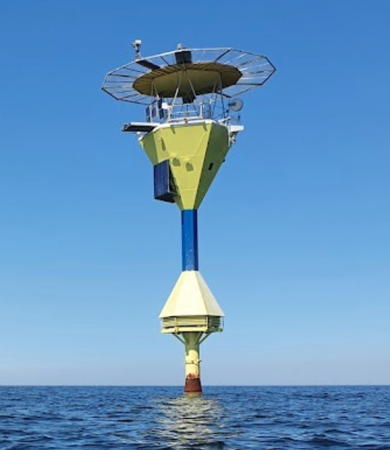
1990. Active; focal plane 23 m (75 ft); four white flashes every 30 s. 23 m (75 ft) steel column supporting a hexagonal equipment structure and a helipad. Lighthouse painted with blue and yellow horizontal bands. Paavo Juntunen's 2020 photo is at the top of this page, Marinas.com has aerial photos, and Bing has an indistinct satellite view. Located on a shoal in the Gulf of Finland about 25 km (15 mi) southwest of Kotka. Accessible only by boat. Site open, tower closed. ARLHS FIN-022; SU 13055; Admiralty C5380; NGA 13560.

Kaunisaari Light, Kotka, July 2005
Flickr photo
copyright Ari Rotonen; used by permission

Information available on lost lighthouses:

Notable faux lighthouses:

Adjoining pages: North: Finland Lakes | East: Vyborg Area | West: Uusimaa

Return to the Lighthouse Directory index | Ratings key

Posted September 17, 2007. Checked and revised August 26, 2023. Lighthouses: 29. Lightships: 2. Site copyright 2023 Russ Rowlett and the University of North Carolina at Chapel Hill.